It looks like you're using an Ad Blocker.
Please white-list or disable AboveTopSecret.com in your ad-blocking tool.
Thank you.
Some features of ATS will be disabled while you continue to use an ad-blocker.

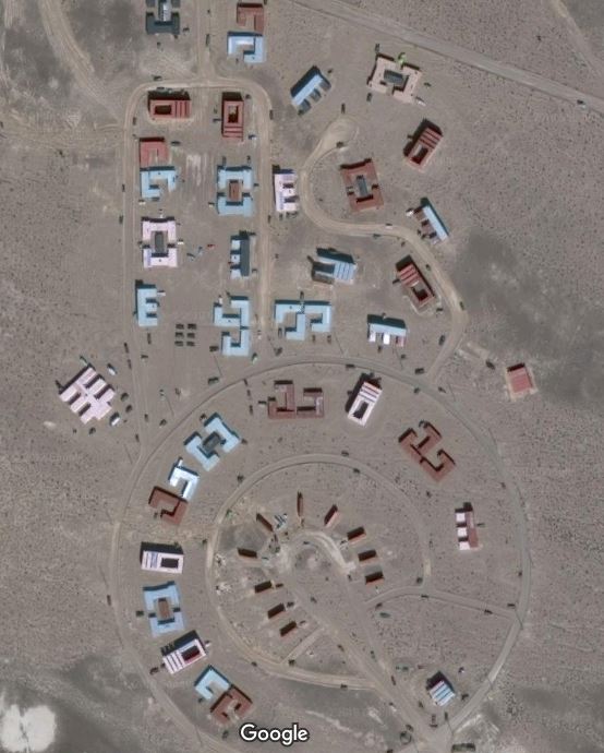
Can someone explain what I found :)
page: 1share:
So I've been using the USGS Satellite images to search around a bit because they seem more detailed then Google's it's more dificult to tell where
exactly you are so when I find something interesting I'll google the coords , Lots of lost and abandoned stuff out there in the desert , I came across
this , it's a bit puzzling maybe some wacko just messing around in the middle of nowhere but would like to find some info on it . Coords are 36.781N
115.444W
Clark County NV.

Clark County NV.
edit on 12/19/2018 by Gargoyle91 because: (no reason given)
edit on 12/19/2018 by Gargoyle91 because: (no reason
given)
edit on 12/19/2018 by Gargoyle91 because: (no reason given)
edit on 12/19/2018 by Gargoyle91 because: (no
reason given)
a reply to: Gargoyle91
You sure those coordinates are right? I entered them in Google Earth and its showing me the side of a mountain in Clark Count Nevada, West of Las Vegas.
You sure those coordinates are right? I entered them in Google Earth and its showing me the side of a mountain in Clark Count Nevada, West of Las Vegas.
edit on 19-12-2018 by Xcathdra because: (no reason given)
Looks like a dirt town with well defined dirt roads.
Cool looking though.
Or maybe a message to aliens in a language we are not seeing. Or some sort of secret base.. idk
Are those even building?
Cool looking though.
Or maybe a message to aliens in a language we are not seeing. Or some sort of secret base.. idk
Are those even building?
originally posted by: Gargoyle91
a reply to: Xcathdra
36.781N 115.444W should be smack in the middle
The coords in your op arent the same as the one you just posted.
ETA
The second coords you posted are the correct ones.
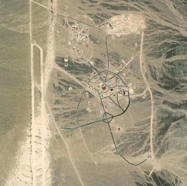
It loks like it is inside the test range for Nellis airforce base (and in the area 51 property - not the base itself but all the land it encompasses.)
edit on 19-12-2018 by Xcathdra because: (no reason given)
Is the majority of that shipping containers? Kind of looks like it to me.
originally posted by: Gargoyle91
a reply to: Xcathdra
just a bit more in the middle the others will get yo there also I just entered them in google and clicked on the map and the went to Sat view
The coordinates you posted in your opening post arent the same ones you posted in response to my question. The second set are the correct coordinates.
The small airbase southwest of the coords you provided has no change since 2011. The planes in the current image are the same ones going back to 2011 and the positions have no changed.
No idea what the place is. I found this part though -
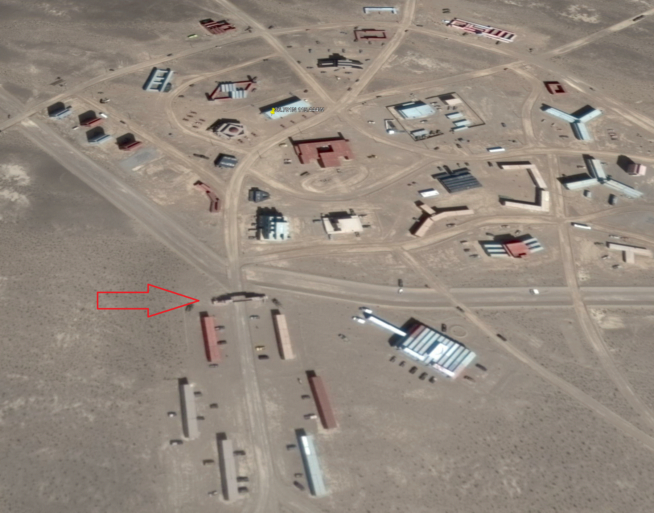
There is some kind of large sign going over the road.
edit on 19-12-2018 by Xcathdra because: (no reason given)
This is what can happen when a state has legalized marijuana.
edit on 19-12-2018 by ausername because: (no reason given)
Reminds me of a training mockup.
Need to run an AI algorithm to match it up with the real urban area somewhere in the world.
Need to run an AI algorithm to match it up with the real urban area somewhere in the world.
edit on 19-12-2018 by CraftBuilder because: Typo
I've got one too
It's a group of people inspired by Slab City
going back to the roots, living OG
getting their stuff together, being cool
and ..?
They're doing well, the community's thriving, evolving...
manages to remain under the authorities' radar...
At least, up until now !
good sleuthing OP
The Feds will be arriving 'presently'
Or, could be, urban street combat layout for troop training
edit on 19-12-2018 by Cassi3l because: spellnig Tourrette fail ........
biscuit... desert... clap ya hands
originally posted by: CraftBuilder
Reminds me of a training mockup.
I was just about to say that it looks like a FIBUA setup,
Well it's been there since at least 2004, but not before 1990. so it could be anything. I do seem to see a mosque there though, so maybe it's a Muslim
compound of some sort, or it could be a private military training area too. There does seem to be some sort of gated and towered area in the lower
half's north east section. Just something to think about.
It does seem to be the building structures there doesn't it.
originally posted by: The GUT
Is the majority of that shipping containers? Kind of looks like it to me.
It does seem to be the building structures there doesn't it.
Looks like a live fire course set up for a specific operation with a convenient runway for flying in personnel and equipment.
Someone with a bunch of shipping containers and too much time on their hands.
I recall seeing a photo of a shipping container town used for bombing practice. It looked a lot like that.
I recall seeing a photo of a shipping container town used for bombing practice. It looked a lot like that.
It's either a training course for the military or the O'Driscoll gang's latest hideout.
new topics
-
VIDEO INSIDE CIA: Project Manager Says Execs and Directors of CIA Withheld Information From Trump
US Political Madness: 42 minutes ago -
Richard Tandy ELO R.I.P.
Music: 2 hours ago -
ICJ Did NOT Find There Was a Plausible Case That Israel Is Committing Genocide
World War Three: 4 hours ago -
The Pentagon is lying about UFOs
Aliens and UFOs: 4 hours ago -
Israel's plans for the West
Above Politics: 4 hours ago -
Who I am is me.
Introductions: 7 hours ago -
White House considers welcoming some Palestinians from war-torn Gaza as refugees
US Political Madness: 8 hours ago
top topics
-
There Are No Adult Leftists
US Political Madness: 14 hours ago, 19 flags -
White House considers welcoming some Palestinians from war-torn Gaza as refugees
US Political Madness: 8 hours ago, 9 flags -
ICJ Did NOT Find There Was a Plausible Case That Israel Is Committing Genocide
World War Three: 4 hours ago, 6 flags -
The Pentagon is lying about UFOs
Aliens and UFOs: 4 hours ago, 3 flags -
Who I am is me.
Introductions: 7 hours ago, 2 flags -
Israel's plans for the West
Above Politics: 4 hours ago, 2 flags -
VIDEO INSIDE CIA: Project Manager Says Execs and Directors of CIA Withheld Information From Trump
US Political Madness: 42 minutes ago, 2 flags -
Richard Tandy ELO R.I.P.
Music: 2 hours ago, 1 flags
active topics
-
College protesters want amnesty.
US Political Madness • 179 • : DBCowboy -
ICJ Did NOT Find There Was a Plausible Case That Israel Is Committing Genocide
World War Three • 21 • : WeMustCare -
Space Time and rubber ducks
The Gray Area • 20 • : DronesandUFOs -
Candidate TRUMP Now Has Crazy Judge JUAN MERCHAN After Him - The Stormy Daniels Hush-Money Case.
Political Conspiracies • 941 • : Annee -
Mood Music Part VI
Music • 3133 • : lilzazz -
-@TH3WH17ERABB17- -Q- ---TIME TO SHOW THE WORLD--- -Part- --44--
Dissecting Disinformation • 769 • : WeMustCare -
whistleblower Captain Bill Uhouse on the Kingman UFO recovery
Aliens and UFOs • 21 • : Ophiuchus1 -
James O’Keefe: I have evidence that exposes the CIA, and it’s on camera.
Whistle Blowers and Leaked Documents • 42 • : pianopraze -
White House considers welcoming some Palestinians from war-torn Gaza as refugees
US Political Madness • 31 • : mysterioustranger -
VIDEO INSIDE CIA: Project Manager Says Execs and Directors of CIA Withheld Information From Trump
US Political Madness • 1 • : pianopraze