It looks like you're using an Ad Blocker.
Please white-list or disable AboveTopSecret.com in your ad-blocking tool.
Thank you.
Some features of ATS will be disabled while you continue to use an ad-blocker.

Primitive Navigation Techniques
page: 1share:
Primitive Navigation Techniques
Ok. I've never posted a thread like this here so I decided to give it a go. Not really your normal survival write up. Not in the sense that I'm trying to tell you how to react in a "what if" scenario. Zombie Apocalypse and nuclear war is not my gig (although I really, really think the Zombie apocalypse is what's gonna happen).
What I wanted to do was run through some ancient navigation techniques. The kind we used to do before the compass and map were even thought of. Could these save your life? Maybe. I know I learned a few things while I was researching that seemed useful.
The weirdest thing is that most of your modern day navigation techniques are based off of these ancient ones. What's even more weird is that these ancient ones are based off of animal navigation. We've gotten new tools to navigate with, yet we use them in concession with the old ones. They are not "instead of" tools, they are "in addition to" tools.
Anyhow, we will be covering how the animals navigate, then how the ancients did, and finally some modern day tips/tricks for getting yourself out of hot water should you become lost in the woods without a compass and a map to guide you. So, first up:
How Animals Navigate
Animals use all their senses to navigate themselves long distances or even just to find their way back home. It's no wonder we took our queue from them and do the same. They all use the same navigational skills for the most part. I'll cover the basics and point out some unique ones below.
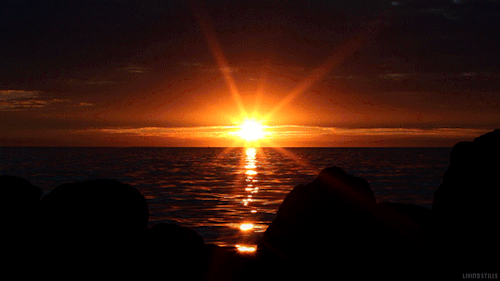
The Sun
The one main navigation skill all animals seem to use is the sun position in the sky. Yep, all land animals and insects use this as a main source to get from point A to point B. The way they use it is sometimes different than how we do though. We watch the progression of the sun across the sky to determine what time of day it is as well as find our bearings. Knowing the sun rises in the East and sets in the West can help you figure out your general position.
Animals do the same. But some also use the polarization of the suns rays to find their way. This is not proven to be used by all animals, there has not been enough studies done. But it is theorized and makes sense:
Polarized light (PL) sensitivity is relatively well studied in a large number of invertebrates and some fish species, but in most other vertebrate classes, including birds, the behavioral and physiological mechanism of PL sensitivity remains one of the big mysteries in sensory biology. Many organisms use the skylight polarization pattern as part of a sun compass for orientation, navigation and in spatial orientation tasks. In birds, the available evidence for an involvement of the skylight polarization pattern in sun-compass orientation is very weak. Instead, cue-conflict and cue-calibration experiments have shown that the skylight polarization pattern near the horizon at sunrise and sunset provides birds with a seasonally and latitudinally independent compass calibration reference. Despite convincing evidence that birds use PL cues for orientation, direct experimental evidence for PL sensitivity is still lacking. Avian double cones have been proposed as putative PL receptors, but detailed anatomical and physiological evidence will be needed to conclusively describe the avian PL receptor. Intriguing parallels between the functional and physiological properties of PL reception and light-dependent magnetoreception could point to a common receptor system. ...
It has been proven that insects use polarization for navigation though. Ants and bees, the dung beetle, bats and some others all depend on this method in order to move about their world (online pdf):
The eyes of insects are sensitive to a natural phenomenon that man is blind to: the polarized light of the daytime sky. It is this capacity that underlies the remarkable navigational ability of many insect species.
There is one point in the sky that by itself leads to unambiguity in navigation: the position occupied by the sun. This point lacks polarized light. It is also the brightest point in the sky. When we followed our desert ants after adapting the tracking vehicle so that the entire sky was depolarized, the navigational ability of the ants became very erratic. This happened in spite of the fact that the position occupied by the sun still remained the brightest part of the depolarized sky. One might conclude that whatever the ant's internal representation of the sky may be, the sun may be predominantly recognized as the point of least polarization.
In bees that point has become particularly meaningful. Because bees have developed the abstract language of the dance as a means of telling one another about navigation angles, each individual worker bee must be able to make use of a reference point that is common to all its fellow workers. Moreover, such a common reference point must be uniquely recognizable within the overall pattern of sky polarization. Therefore the position of the sun-the point of zero polarization-is the only point bees could select for unambiguous communication. The importance of the sun as a cue in bee navigation may well have resulted from its lack of polarization rather than from its relative brightness ...
Polarization helps when the day is overcast, when the sun is not visible. It keeps the insects and animals from losing their way. So, you have the suns' position in the skies and it's polarization as the primary way that animals navigate.
Continued...
edit on 14-4-2018 by blend57 because: Always an Edit! :/
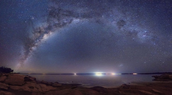
The Moon and Stars
Most of the time these are listed separate. But I think they go together honestly. It is said that you should always use more than one way to determine direction. And I think that animals use both the moon and stars combined in order to find their way. Well, I don't just think that, scientists have proven it:
While a number of animal species have been demonstrated to use the stars as a source of directional information, the strategies that these animals use to convert this complex and variable pattern of dim-light points into a reliable ‘stellar orientation’ cue have been more difficult to ascertain. In this review, we assess the stars as a visual stimulus that conveys directional information, and compare the bodies of evidence available for the different stellar orientation strategies proposed to date. In this context, we also introduce new technologies that may aid in the study of stellar orientation, and suggest how field experiments may be used to characterize the mechanisms underlying stellar orientation. ...
The link goes through several ways that animals use the night time sky to navigate. For instance, celestial birds:
During their autumn migration, wild-caught birds were presented with an autumn starry sky in the Longway Planetarium (Flint, Michigan) while constrained within funnels of blotting paper that monitored the direction of their hops when they attempted to take-off. Their hops were consistently oriented southwards, as when presented with a real starry sky [13]. This behavior persisted with the removal of successive constellations, and P. cyanea was only disoriented when all of the constellations within 35° of Polaris were blocked from view [14]. Birds attempting to migrate south in autumn, and those manipulated physiologically for early spring migration northwards, displayed season-appropriate orientation when presented with the same planetarium sky [15]. Various attempts to demonstrate stellar orientation in other migratory bird species [16–19] indicate that several other night-migrating species also use the centre of celestial rotation as their stellar orientation reference.
And seals:
In a series of studies involving the harbour seal Phoca vitulina, it was established that seals can detect simulated and real bright stars [29] and that they can learn to orient within a floating planetarium [30].
So animals use the position of the stars, moon, and the polarization of moon light to find their way in the dark. Not every animal uses all three, but usually a combination of them.
continued...
edit on 14-4-2018 by blend57 because: Always an Edit! :/
Path integration:
It is often assumed that navigation implies the use, by animals, of landmarks indicating the location of the goal. However, many animals (including humans) are able to return to the starting point of a journey, or to other goal sites, by relying on self-motion cues only. This process is known as path integration, and it allows an agent to calculate a route without making use of landmarks
That's the clearest/simplest definition I could find. Animals use this to navigate short distances mostly. A simple example would be knowing where "home" is and traveling 200 paces North, then 200 paces to the right, then another 200 paces to the right, then once more. Doing that will get you back to your starting point. It can be as simple or complex as you need it to be honestly. But the point is to keep track of the distance you cover rather than the land marks or direction.
Ants use this as a form of navigation all the time. They don't need the visual queues such as land marks or the sun to get them where they wish to go. As long as they keep track of the distance covered while walking in a straight line, they are fine. If they veer off track, they know how many steps they took and can set themselves back on course by using path integration as well.
Path integration—first postulated by Darwin (1873) and described by Murphy (1873), in reply to Darwin, as the integration of inertial signals— appears to operate in a great number of diverse species with a fixed home base, both vertebrate and invertebrate, during the exploration of a new environment or in commuting between the home and familiar resource sites. It may also provide continuous information to the animal about where it is located on its internal representation of space (Gallistel, 1990), particularly in the intervals between visual fixes (e.g., in darkness). PI functions automatically and constantly, whenever the agent moves in continuous space. Thus, a central place forager may, for instance, interrupt its excursion to return home at any place and at any moment of its journey ...
I personally do not think animals use this alone. I think it is used with the other visual queues in order to maintain their positioning. But it could be used alone if necessary. If they always start out using it and then have no other means to get back to their home base, this would work in order to accomplish that. They use it instinctually, it's a second nature to them.
Charles Darwin also thought that animals (including humans) where instinctually able to navigate this way. A letter he wrote for nature magazine:
With regard to the question of the means by which animals find their way home from a long distance, a striking account, in relation to man, will be found in the English translation of the Expedition to North Siberia, by Von Wrangell.[note 1] He there describes the wonderful manner in which the natives kept a true course towards a particular spot, whilst passing for a long distance through hummocky ice, with incessant changes of direction, and with no guide in the heavens or on the frozen sea. He states (but I quote only from memory of many years standing) that he, an experienced surveyor, and using a compass, failed to do that which these savages easily effected. Yet no one will suppose that they possessed any special sense which is quite absent in us. We must bear in mind that neither a compass, nor the north star, nor any other such sign, suffices to guide a man to a particular spot through an intricate country, or through hummocky ice, when many deviations from a straight course are inevitable, unless the deviations are allowed for, or a sort of "dead reckoning" is kept. All men are able to do this in a greater or less degree, and the natives of Siberia apparently to a wonderful extent, though probably in an unconscious manner. This is effected chiefly, no doubt, by eyesight, but partly, perhaps, by the sense of muscular movement, in the same manner as a man with his eyes blinded can proceed (and some men much better than others) for a short distance in a nearly straight line, or turn at right angles, or back again. The manner in which the sense of direction is sometimes suddenly disarranged in very old and feeble persons, and the feeling of strong distress which, as I know, has been experienced by persons when they have suddenly found out that they have been proceeding in a wholly unexpected and wrong direction, leads to the suspicion that some part of the brain is specialized for the function of direction. ...
Those are the main ones that animals use. Yep, there are more such as land marks, Earth's magnetic field, wind, water, and smells. They don't rely on just one thing and what they use to navigate is determined by their environment. This is not dissimilar to how we, as humans used to navigate. When I said that we took our queues from the animals...I wasn't lying.
If you read any survival article, watch a video, or attend a survival class these will be what are taught to you in order to prep you for navigation without a map and compass. They are the "go to" techniques that have been proven time and time again to be effective.
The next part is going through how we used these skills in the past. I'm not talking about modern day usage, I'm talking about back before technology. When we used to traverse the world using only our brains and instinct. And I think I am gonna start with the Vikings!
Continued...
edit on 14-4-2018 by blend57 because: Always an Edit! :/
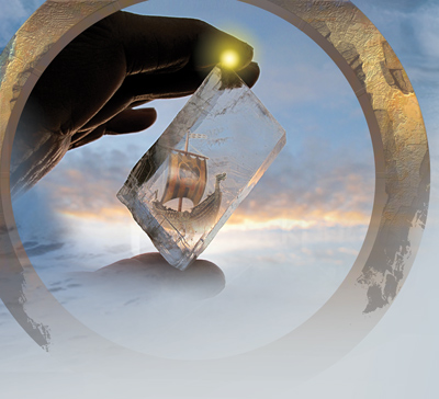
Viking Navigation
The Vikings used the sun a lot to navigate. They were able to go out into the vastness of the ocean when others had to keep the shoreline in sight. Of course they didn't just rely on the sun to guide them, but it was one of their primary means of navigating.
Vikings have gone down in history as legendary navigators, sailing their long ships to places like Britain, Ireland, Greenland and even Newfoundland. Without magnetic compasses or tools like astrolabes, the Vikings likely relied on primitive solar compasses to navigate, which uses the position of the sun to determine north.
Although the Vikings are widely known to have been excellent mariners, exactly how they navigated the seas is not well understood. Since the northern Atlantic Ocean where they sailed has up to 24 hours of daylight in the summer, they could not have relied heavily on the stars, but likely took full advantage of the sun to navigate.
To make sure that this parts falls in line with the premise of the thread, I checked out what a primitive solar compass was:
Compasses that used the angle and length of the sun's shadow to determine the position of the north were used throughout of human history in several forms, ranging from simple techniques used in ancient Greece and Rome to the caved half-discs of Viking sailors that could not only work during the day, but also very reliable (with just a few percent of error) determine the position of the north even up to 45 minutes after the sunset. ...
Ok, so that was a bit of a bummer. They used a primitive machine to track the progression of the sun and find North. But it actually isn't a bummer because there is possible alternative to what the primitive solar compass was used for:
Although eleventh-century Vikings did not have magnetic compasses at their disposal, it is thought that they could determine their orientation at sea using sun-compasses. Sun-compasses use the position of the sun's shadow to tell which way north is, and look somewhat similar to sundials, which use the position of the sun's shadow to tell the time of day. But the famous Viking-era wooden fragment that inspired the idea that Vikings used sun-compasses contains some lines that don't quite match scientists' interpretations. In a new study, a team of researchers has proposed that these flaws hint at the possibility that the instrument served a more sophisticated purpose than determining orientation, which was determining latitude. ...
So, they very well could've visually used the sun to keep on course. At this point in time, what they used the "sun compass" for is still up for debate.
The other piece of science that has been updated is the sun stone they were thought to have used. This is not a made up thing (I thought it was at first...) This is a tool that is mentioned in a few of their writings. So far though, none have been found. But they have been able to establish that it would work. And they have found it would increase the accuracy of navigation upwards to 92.2-100% in some scenarios.
Our results show that the sky-polarimetric navigation is surprisingly successful on both days of the spring equinox and summer solstice even under cloudy conditions if the navigator determined the north direction periodically at least once in every 3 h, independently of the type of sunstone used for the analysis of sky polarization. This explains why the Vikings could rule the Atlantic Ocean for 300 years and could reach North America without a magnetic compass. Our findings suggest that it is not only the navigation periodicity in itself that is important for higher navigation success rates, but also the distribution of times when the navigation procedure carried out is as symmetrical as possible with respect to the time point of real noon.
If the navigation periodicity Δt is 1, 2 or 3 h, then the navigation success s is between 92.2 and 100% for all three sunstones and at both spring equinox and summer solstice. ...
There are some variables that the accuracy rate is dependent on. Frequency of use and time of year were important. But under the right conditions it worked well. This may not have been their primary tool used to navigate, but it seems like it may have been one of many. This also, if true, would show the use of polarization of the suns rays in order to navigate, which is the way some animals navigate as well.
The Vikings used all their senses to navigate but primarily counted on the suns progression and used it with other variables such as the wind, waves, and smells of the ocean to get them where they needed to be.
Continued...
edit on 14-4-2018 by blend57 because: Always an Edit! :/
The Aboriginals Star Maps
Aboriginal Australians are the oldest continuing culture on Earth, and have been living in Australia for over 50,000 years. They may be the world’s oldest astronomers, as their culture has retained much astronomical knowledge, passed down through stories, song and art. They have a sophisticated knowledge of the night sky, including the movement of the Moon and its effect on the tides, the mechanism of solar eclipses, and the location and movement of planets and stars down to 5th magnitude.
I chose the Aboriginals as an example of how we track the stars just like animals do because they are kind of experts at it. The oldest continuing culture on Earth has to have retained some super cool ancient knowledge and it seems that they did.
But, they use the stars a little differently then we do. Normally we use the North star to figure out direction. They use constellations to map way points when traveling. Memorizing the constellation in order to know where the food and watering points are along the way. The survival basics that every person would need to know in order to travel long distances. This is not to say that they don't use them for navigation, but it is a unique way of using nature to help you survive.
For instance the following picture shows the star map the aboriginals use for Carnarvon Gorge and Bunya Mts . overlaid onto a road map. You can see the routes are quite similar.
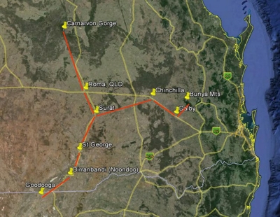
The stars match up with the cities and are where a traveler can find survival resources. Obviously the difference being that there are cities/towns at each star point now instead of watering holes or places to find food.
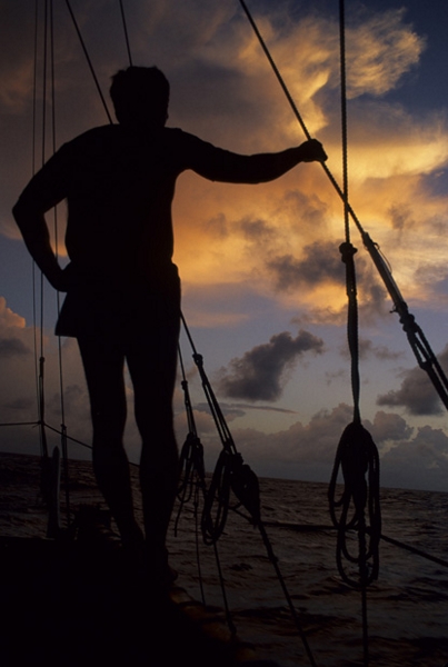
Polynesians and Dead Reckoning
The Polynesians were known for their ability to use the stars as navigating tools as well. But a lot of the time they would also use Dead Reckoning. This is similar to Path Integration up in the animal section. The difference is that we normally would use tools such as maps and charts to get our distance and speed in order to figure out where we were going. The Polynesians didn't use tools, they did it all in their heads:
traditional Pacific navigators (and Western navigators before the time of Cook) had no way in which they could precisely fix their position on the open ocean as modern, instrument navigators can. Instead, Pacific navigators were accomplished in the art of dead reckoning, a world-wide practice whereby a navigator deduces his position from estimates of course and speed “made good” after allowing for the estimated effects of leeway (sideways drift of the vessel caused by the wind) and current.
Pacific Island navigators, however, had to develop a system which allowed them to overcome a very special handicap: without written language, their practice of navigation was entirely mental, with reckoning of position being carried forward through the voyage in a navigator's memory. The continuous level of concentration required is much higher than in modern navigation, with its written logs, and plots on charts, regularly updated.
Exactly how traditional Polynesian navigators used dead reckoning is not known. For the Caroline Islands there are abundant data on a dead reckoning system which involves mentally dividing a voyage into segments marked by the change in the bearing of an etak or “reference” island, as judged by its envisioned movement from one star compass point to another ...
Let me point out that each group I focused on for in this last section all used every navigational technique available to them. But for the purpose of this thread and to show a comparison, I wanted to focus in on one specific area for each example. This is no different than how animals use all navigational tools available to them in order to make it to their destination.
There are a few navigational techniques that I mentioned in passing which were also used to gauge direction and course such as wind speed/direction, the clouds, types if animals found in each geographical location (deep sea fish versus coastal fish), plants and visual land marks. Even smell was often used to determine if you were close to land or not.
I'll go through how they were used real quick here and then move finish up with other navigational tips you can use when you don't have a map or compass in a survival situation.
Continued...
edit on 14-4-2018 by blend57 because: Always an Edit! :/
Other Navigational Techniques
The clouds:
- The direction they are heading while passing over the sun/north star would help people know what direction they were heading in.
- Stationary clouds out on open water could be evidence that there is land under them.
- They also looked for reflections on the underside of clouds that could denote land such as green or brown hues, dark shadows, etc..
Wind
- If the wind was moist, they would know that it was coming from the coastal regions.
- If it was cold, it came from the North
- If it was warm, it came from the south
Using these three rules in conjunction with one another would give them a pretty good idea of the direction they were headed in if they were on land and a general direction if they were at sea.
Animals
- The amount of birds in one area told them how close land was.
- They followed the bird migration routes knowing they would stop once they reached land. (both short and long migration)
- On land they would follow the land animal migration routes as well.
- They used the trails forged by animals to find their way to food/water sources and sleeping/camp areas.
- They also watched what the animals ate and drank to know if it was safe for them to drink/eat as well
Water
- Utilizing the waves to find land. Islands block waves and swells. They reflect and refract. watching the waves interact was one way to set a
course for land.
- There is a zone of calmer water behind an island. They looked for these zones in order to find land and know what direction to head
- Recognizing the plants, aquatic life in the water. For instance algae only grows near the shore (it will float out to sea though).
There are eight distinct swells. Each one is connected to a specific position of a star on the star compass. But swells tell more than what course you’re on. If you can read their shapes, you can know the strength and direction of the current running beneath them. If you don’t know what the current’s doing, you can steer a perfect course and still become lost. ...

Smell
Smell I'm not gonna list anything for. Basically they used the smells that were carried on the wind to figure out where land was. Some times certain areas have very distinct smells. For example an island that has a ton of orange trees growing on it may carry the smell of citrus in the wind. Basically any smell that didn't smell like the sea would be used in conjunction with the other skills above to determine if land was close by.
So, that's it for this section. How ancient humans used the same navigational skills as animals did in order to explore the world without a map and compass. Pretty amazing that we did such things. Also is a bit of shame that we are losing the knowledge to do them.
Realistically I imagine most people would use the sun, moon, and stars as navigational choices if they were stuck out in the wilderness/at sea without a compass and map. But, it doesn't hurt to know about the other things and use them in addition to celestial navigation.
The next section just deals with finding your way out of a place when lost. I'm not going to talk about the navigation skills above (no need to beat a dead horse). But I will list some others that make sense and are useful. I will also try to expel any myths and say why I wouldn't use some of these. We'll see how well I do..lol
Continued...
edit on 14-4-2018 by blend57 because: Always an Edit! :/
Additional Primitive Navigating Tips
This is where I put my disclaimers:
#1: I am not a professional and even though I've researched and watched and done some of these things, I cannot guarantee that they will work for you in your survival situation. All I can guarantee is that in at least some cases they did work.... The thing is, you have to make the choices on what to do according to the situation you are in. Survival skills are not one size fits all scenarios.
#2: The best advice anyone can give you is to stay put if you become lost. Especially if you are not used to and haven't practiced any of these techniques in real life. Hopefully you've followed the number one rule before wondering off into the woods or exploring...tell someone where you're going and how long you expect to be gone. That is the number one life saving tip. Even seasoned survivalists follow that rule every time they go out.
With all that being said, here are some tips that may help you navigate your way out of the wilderness.
Do your Research
If you are going camping or hiking, it is best to know the area you are going hiking in. If you haven't been there before, do an online search and look at the terrain and paths, map out your route, find some land marks and know where and in which direction all the towns/cities closest to your camp/hiking area are.
This is pretty important when trying to choose a direction to go in if you get lost or are stuck in a survival situation.
Be Prepared
Nope, not talking about your pack... you've already had that ready to go for awhile now. I'm talking more about being prepared for getting lost. Most of the time we prepare ourselves for the trip only. Meaning taking only what you need for a 3 day hike or camping excursion. We rely on our cell phones and GPS, maps and compasses in order to get us out of survival situations. But what if none of that is available? What if they get damaged or you lose your pack, or, you forget to take them in the first place? That is what I mean by being prepared to get lost. It is not about the tech you have, but about how you can survive without it. What low tech gear can you take that would do the job?
A few things suggested that you might not have thought about are: have a whistle on you, something bright to wrap around a tree to mark your trail and direction on, and a magnetized needle for a makeshift compass with. These are all things that take up little to no room and are multi-functional. And they can be used no matter if you lose your pack or not because they are with you at all times.
Follow a Handrail
This is talking about finding a river or animal trail and following that. If you find a river, follow it downhill, not uphill. Most towns/cities are at the base of mountains. If you find an animal trail it should lead you to a river or water source...possibly to a road as well. Animals like to take the path of least resistance too. The point is that it will help guide you to safety and also keep you walking in a straight line. Which is the next tip.
Practice Walking in a Straight Line
This...this is pretty hard for most people to do. lol. But it is necessary. One of the most common things that happens when people get lost is they go full circle and find themselves back at or close to their original location. It's a waste of time and energy. When you are in survival mode, you can't waste time and energy.
Two reasons that I have found noted why we do this:
#1: We tend to follow the terrain without knowing it when we lose our sense of direction. We do this pretty much all the time honestly. But in a survival situation, you can't afford to do it. You need to know that the energy your are using up is getting you someplace.
#2. We tend to be heavier footed on one side than the other. Which means that over time we will trek a little to the right or left (depending on which foot you favor), eventually changing direction completely. Again, we can't afford to waste the time and energy.
Enjoy the Sunrise/set
Yep, back to the sun. This is just a small reminder though that you can get a general idea of where you are by watching the sun rise and sunset each day. It is a visual queue to help you get your bearings before you start your daily trek.
Avoid Night Time Navigation
If possible, try to camp at night and don't move until the sun comes up. Tackling the terrain and trying to stay on course is way more difficult without the sun. Not too mention your risk of injury is much, much higher. When you are alone in the wilderness in a survival situation, you are trying to minimize risk. Find a place to camp each night and start off new in the morning.
Don't Panic
This should be the number one tip...and it is. When you realize you are lost most people tend to go into panic mode. You need to relax and assess the situation. Don't move until you've come up with a plan. And make sure that plan is solid. Sometimes you can think about it and find your way back to the starting point. Sometimes you have to devise a way to get yourself somewhere else. The worst thing you can do is keep moving even though you are lost without some sort of plan.
Don't Rely on Technology
I've read a bunch of stories about people climbing up to higher ground in order to get a phone signal(and not getting one), people relying on GPS and only packing that as a way to navigate, and also, people taking a map and compass but not knowing how to use them.
I would say that all those things are really nice to have, but knowledge about how to navigate without them is better (in the map and compass scenario, just knowledge on how to use them would be helpful). Practice these primitive navigation techniques while you have the security of a working GPS or cell phone, not when you don't. It is the safest way to learn how to do some of these techniques without risking getting lost while doing them.
That's all I have. There are other tips and I'm hoping people will post some. But I think, for me, these sound the most valuable and easiest to remember. They're things you can do in any survival situation to navigate yourself back to civilization and they work in every area of the world.
So...what did I get wrong and what did I leave out? lol.
As always, thanks for reading...
blend57
edit on 14-4-2018 by blend57 because: Always an Edit! :/
Wow, nice thread but........
It's pretty easy to navigate. Not really that complicated.
If you have ever been camping or hiking, you just become familiar with the sun and stars.
Back when I was a teenager living in Iowa, I would sometimes use constellations to give me direction home.
Now, think about it, if a drunk teenager can find his why home while way past is curfew, it's not that hard to use stars, sun and other such things in the sky to navigate by.
a reply to: blend57
In the northern hemisphere, satellite dishes usually point south.
Also moss on trees, it is usually found on the north side of trees due to retaining more moisture in the shadow of the sun.
ETA Moss link and explanation
Good OP!
In the northern hemisphere, satellite dishes usually point south.
Also moss on trees, it is usually found on the north side of trees due to retaining more moisture in the shadow of the sun.
ETA Moss link and explanation
Good OP!
edit on 14/4/18 by LightSpeedDriver because: Reply fix
edit on 14/4/18 by LightSpeedDriver because: ETA
Very cool! Commenting so i can come back and read the whole thread later.
originally posted by: blend57
Path integration:
It is often assumed that navigation implies the use, by animals, of landmarks indicating the location of the goal. However, many animals (including humans) are able to return to the starting point of a journey, or to other goal sites, by relying on self-motion cues only. This process is known as path integration, and it allows an agent to calculate a route without making use of landmarks
That's the clearest/simplest definition I could find. Animals use this to navigate short distances mostly. A simple example would be knowing where "home" is and traveling 200 paces North, then 200 paces to the right, then another 200 paces to the right, then once more. Doing that will get you back to your starting point. It can be as simple or complex as you need it to be honestly. But the point is to keep track of the distance you cover rather than the land marks or direction.
I remember the fun of moving to a new city when I don't know any of the landmarks. First thing to learn was how all store fronts were relative to each other. I'd end up with a grid of pictures in my mind, then I slowly connected sets of buildings together (shop A is opposite shop B and next to store C), as well as the direction they faced and the direction of each street. The final layers were the direction to home, the railway station, bus station and shopping malls. The biggest hazard were McDonalds shops with doorways on the corners. One was an entrances and the other was an exit. I ended up getting lost because the usual rule of "reverse the directions you turned" doesn't work and only ended me up in the wrong neighborhood.
originally posted by: InspectorGadget13
Very cool! Commenting so i can come back and read the whole thread later.
Same here. Yet another navigation technique.
OP, If I could pay you for that, I would. It seems like stealing somehow when you get a wealth of information like that for free.
That was excellent. Keep up the good work.
Navigation without a Smartphone!
I can use a compass and map - that's easy, but also a learnt skill. My father who was an army pilot could navigate via the stars and taught me a little about astronomy, but not enough beyond how to point north. But, I have a appreciation of the night's sky because of it.
I recently read a book on the desert campaign in WW2, where the use of a sun compass was widely used. If you know the time of day, then you can calculate any direction by the fall of shadow.
There are also hints from nature. Moss tends to grow on the north side of a tree, and cows and deer tend to lie in a north-south direction.
Good stuff
Confession time. I once walked all day in the mist and ended up exactly where I started from. Unfortunately there were witnesses. A compass would have
prevented that.
a reply to: LightSpeedDriver
Thanks for the additional information! While I was reading through stuff I found a lot about urban navigating in the links as well. The satellite thing they mentioned as well as headstones in graveyards and older churches..both normally face east. But then I read further and that is no longer true for all cemeteries and churches. Most of the articles led back to using the sun,moon, and stars as your guide as they were the most consistent source for finding your direction.
Thanks to everyone who commented or read through the thread. Very nice of you to take the time to do so...
blend
a reply to: blend57
A couple of months ago I saw an article about the Polynesians on how they could go to all these islands in the Pacific. I wish I could find it again and link to it. Basically, some of them trained through a kind of apprenticeship to read the ocean waves They say they are able to "feel" the currents and detect far away islands using the reflections of waves from distant shores. Apparently it's a dying art. Only one or two people are still around that can do this.
They also made maps using sticks in a kind of a grid pattern with other sticks inserted to indicate currents and islands.
a reply to: blend57
Great thread packed full of useful information, really nice work blend57.
I don't have much to contribute but I will say this, we are animals too and despite what we have forgotten we still have the internal mechanisms for navigation.
I loved the Darwin quote, I've had very similar thoughts on the subject. I've been fascinated with the idea of a sense of direction for a while.
I think the brain adds a lot of things up subconsciously, kind of like striking the ball in a game of rounders or baseball, we are not thinking about speed or angle of the ball, there simply isn't enough time for that and from personal experience it's the thinking that usually makes you miss. That's something I've noticed when trying to gather my own bearings so to speak.
I naturally keep track of the Sun's location, knowing what time of the year it is gives a great clue of where north/south is since I live in the UK (south in the winter) but with that being said when a few visual cues are unreadable, like whilst in the city I can become somewhat confused.
It's this confusion that has always fascinated me. It's the thinking that usually gets me lost too... Unless I've got a background on today's weather.
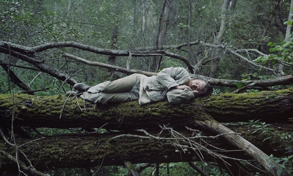
Forests have always been my bane, it helps to know that moss does not like growing in the sun. So given the time of year this can be a good indicator of north or south, given you don't live in the equator.
Again great thread, a lot to consider and think about.
To add:
In terms of the equinoxes and solstices for using navigation, it would be interesting to know the average weather formations that occur during these times, especially at sea. It might just be that it is a perfect time to go sailing in certain directions.
Great thread packed full of useful information, really nice work blend57.
I don't have much to contribute but I will say this, we are animals too and despite what we have forgotten we still have the internal mechanisms for navigation.
I loved the Darwin quote, I've had very similar thoughts on the subject. I've been fascinated with the idea of a sense of direction for a while.
I think the brain adds a lot of things up subconsciously, kind of like striking the ball in a game of rounders or baseball, we are not thinking about speed or angle of the ball, there simply isn't enough time for that and from personal experience it's the thinking that usually makes you miss. That's something I've noticed when trying to gather my own bearings so to speak.
I naturally keep track of the Sun's location, knowing what time of the year it is gives a great clue of where north/south is since I live in the UK (south in the winter) but with that being said when a few visual cues are unreadable, like whilst in the city I can become somewhat confused.
It's this confusion that has always fascinated me. It's the thinking that usually gets me lost too... Unless I've got a background on today's weather.
Forests have always been my bane, it helps to know that moss does not like growing in the sun. So given the time of year this can be a good indicator of north or south, given you don't live in the equator.
Again great thread, a lot to consider and think about.
To add:
In terms of the equinoxes and solstices for using navigation, it would be interesting to know the average weather formations that occur during these times, especially at sea. It might just be that it is a perfect time to go sailing in certain directions.
edit on 15-4-2018 by RAY1990
because: Added something
a reply to: blend57
Back in the day it was the custom to have the dead laid to rest facing east.
On a side note I once read that dogs do their business in a north/south axis. Some animals rest this way and cows seemingly graze on a north/south axis though I suspect that's more a survival technique, the Sun's glare can often be dangerous.
a reply to: blend57
Fantastic research and useful information as usual.
There's another primitive technique I've read about but not tried. Let's face it, I've been lazy LOL
It's putting a stick in the ground and using pebbles to get your coordinates, then if you've researched the area that you are in beforehand you can hopefully find that river to the north or road or where the town was on your way to your current location...I'll try to find something on that and send you the link.
new topics
-
Fun with extreme paints
Interesting Websites: 1 hours ago -
CIA is alleged to be operat social media troll frms in Kyiv
ATS Skunk Works: 2 hours ago -
Rainbow : Stargazer
Music: 3 hours ago -
I sleep no more.
Philosophy and Metaphysics: 5 hours ago -
Canada caught red-handed manipulating live weather data and make it warmer
Fragile Earth: 5 hours ago -
Why Files Our Alien Overlords | How We Secretly Serve The Tall Whites
Aliens and UFOs: 7 hours ago -
Curse of King Tuts Tomb Solved
Ancient & Lost Civilizations: 8 hours ago -
What allies does Trump have in the world?
ATS Skunk Works: 8 hours ago
top topics
-
Canada caught red-handed manipulating live weather data and make it warmer
Fragile Earth: 5 hours ago, 15 flags -
BIDEN Admin Begins Planning For January 2025 Transition to a New President - Today is 4.26.2024.
2024 Elections: 17 hours ago, 10 flags -
Why Files Our Alien Overlords | How We Secretly Serve The Tall Whites
Aliens and UFOs: 7 hours ago, 9 flags -
Curse of King Tuts Tomb Solved
Ancient & Lost Civilizations: 8 hours ago, 7 flags -
What allies does Trump have in the world?
ATS Skunk Works: 8 hours ago, 3 flags -
CIA is alleged to be operat social media troll frms in Kyiv
ATS Skunk Works: 2 hours ago, 3 flags -
I sleep no more.
Philosophy and Metaphysics: 5 hours ago, 1 flags -
Fun with extreme paints
Interesting Websites: 1 hours ago, 1 flags -
Rainbow : Stargazer
Music: 3 hours ago, 0 flags
active topics
-
Definitive 9.11 Pentagon EVIDENCE.
9/11 Conspiracies • 431 • : Lazy88 -
Silent Moments --In Memory of Beloved Member TDDA
Short Stories • 71 • : zosimov -
I sleep no more.
Philosophy and Metaphysics • 7 • : GeorgeVanTassel -
Falkville Robot-Man
Aliens and UFOs • 14 • : GeorgeVanTassel -
Gov Kristi Noem Shot and Killed "Less Than Worthless Dog" and a 'Smelly Goat
2024 Elections • 85 • : UpIsNowDown2 -
Supreme Court Oral Arguments 4.25.2024 - Are PRESIDENTS IMMUNE From Later Being Prosecuted.
Above Politics • 116 • : Sookiechacha -
Shocking Number of Voters are Open to Committing Election Fraud
US Political Madness • 11 • : Astrocometus -
Canada caught red-handed manipulating live weather data and make it warmer
Fragile Earth • 23 • : GeorgeVanTassel -
CIA is alleged to be operat social media troll frms in Kyiv
ATS Skunk Works • 14 • : Oldcarpy2 -
-@TH3WH17ERABB17- -Q- ---TIME TO SHOW THE WORLD--- -Part- --44--
Dissecting Disinformation • 711 • : daskakik