It looks like you're using an Ad Blocker.
Please white-list or disable AboveTopSecret.com in your ad-blocking tool.
Thank you.
Some features of ATS will be disabled while you continue to use an ad-blocker.

Oroville dam within Quarter inch of overflowing over emergency spillway
page: 1share:
Anyone near here? I have heard the emergency spillway is in serious danger of collapse, and the collapse is going UP, not down, probably due to
turbulence in the water.
I heard this an hour ago, melt water is imminent to overtop ....... anyone able to give an update
Thanks
I heard this an hour ago, melt water is imminent to overtop ....... anyone able to give an update
Thanks
edit on 2017-02-11T16:25:16-06:002017Sat, 11 Feb 2017 16:25:16 -0600bSaturday2502America/Chicago174 by corblimeyguvnor because: (no
reason given)
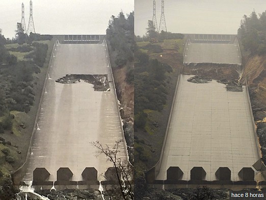
Who did the design.....my...my
Undercut from the sidewalls letting water pump under the flat work......big mistake
Rip it all out and do another one, this time with brain engaged.
Undercut from the sidewalls letting water pump under the flat work......big mistake
Rip it all out and do another one, this time with brain engaged.
originally posted by: lostbook
a reply to: corblimeyguvnor
Where is this?
Oroville California USA...
Looks like big trouble !!!!!!!!!!!
Water flowing over emergency spillway at tallest US dam
Water flowing over emergency spillway at tallest US dam
Water flowing over emergency spillway at tallest US dam
[Associated Press]
MICHAEL BALSAMO and RICH PEDRONCELLI
Associated PressFebruary 11, 2017
View photos
Water flows through break in the wall of the Oroville Dam spillway, Thursday, Feb. 9, 2017, in Oroville, Calif. The torrent chewed up trees and soil alongside the concrete spillway before rejoining the main channel below. Engineers don't know what caused what state Department of Water Resources spokesman Eric See called a "massive" cave-in that is expected to keep growing until it reaches bedrock. (AP Photo/Rich Pedroncelli)
OROVILLE, Calif. (AP) — Water started flowing over an emergency spillway at the nation's tallest dam, on Lake Oroville, for the first time Saturday after erosion damaged the Northern California dam's main spillway.
Officials hoped to avoid using Oroville Dam's emergency spillway, fearing it could cause trees to fall and leave debris cascading into water that rushes through the Feather River, into the Sacramento River and on to the San Francisco Bay. Crews prepared for several days, clearing trees and brush.
Water began running over the emergency spillway around 8 a.m., according to California's Department of Water Resources. It was the first time the emergency spillway has been used in the reservoir's nearly 50-year history.
a reply to: corblimeyguvnor
Water is now rushing over emergency spillway.
sanfrancisco.cbslocal.com...
A video from a local person.
Water is now rushing over emergency spillway.
sanfrancisco.cbslocal.com...
A video from a local person.

a reply to: corblimeyguvnor
Started at about 8:00 am today (Saturday).
Expected to continue for several days.
Lets hope it holds up.
The State needs to get off its lard and stop whining about
the drought and actually do something to fix the infastructure.
Weather like this is common there, happens in cycles.
They have had since 2011 to do something rather than
raise taxes and fix nothing.
Started at about 8:00 am today (Saturday).
Once the water level of Oroville Lake rises above a certain elevation,
water begins to flow automatically into the emergency channel.
SFGate
Expected to continue for several days.
Lets hope it holds up.
The State needs to get off its lard and stop whining about
the drought and actually do something to fix the infastructure.
Weather like this is common there, happens in cycles.
They have had since 2011 to do something rather than
raise taxes and fix nothing.
edit on 11-2-2017 by burntheships because: (no reason given)
edit on 11-2-2017 by burntheships because: fix link
Would it be bad form to crack a joke about that spill way ?
Cause there's some great ones to be made.
Cause there's some great ones to be made.
a reply to: burntheships
I guess it is TOO LATE, short term, you can't have fixers working if that turbulence happens. If it continuances up hill as it seems to be, hope them Pylons and the electrical system hold out
I guess it is TOO LATE, short term, you can't have fixers working if that turbulence happens. If it continuances up hill as it seems to be, hope them Pylons and the electrical system hold out

originally posted by: corblimeyguvnor
a reply to: burntheships
I guess it is TOO LATE, short term, you can't have fixers working if that turbulence happens. If it continuances up hill as it seems to be, hope them Pylons and the electrical system hold out
Yes, it is too late now. Cal Fire was busy for a week cutting trees off the
emergency spill way, which is just dirt. They cleared the trees so they
would not rip out and cause more damage.
Here is a HD video aerial view from a copter, gives you an idea of how much water is flowing.
edit on 11-2-2017 by burntheships because: (no reason given)
a reply to: xuenchen
This part of that article is concerning.
Is that a massive sink hole?
Is the earth destabilizing for another reason?
Could this lead to earthquakes?
Could this have been caused by an earthquake?
This part of that article is concerning.
Unexpected erosion chewed through the main spillway earlier this week, sending chunks of concrete flying and creating a 200-foot-long, 30-foot-deep hole that continues growing. Engineers don't know what caused the cave-in that is expected to keep getting bigger until it reaches bedrock.
Is that a massive sink hole?
Is the earth destabilizing for another reason?
Could this lead to earthquakes?
Could this have been caused by an earthquake?
edit on 2/11/17 by BlueAjah because: (no reason given)
L A Times
That article is from 45 minutes ago at time of posting. Sounds like there is no threat?
Water started flowing down the spillway into the Feather River early Saturday, with officials continuing to emphasize there was no imminent threat to the public or to the integrity of the dam.
"Relatively speaking, it's a small spill," See said, noting that the flow over the emergency spillway is expected to end in the next 38-56 hours.
"The lake will actually drop and the spill will cease," he said.
The dam is not threatened by these conditions,” said Bill Croyle, acting director of the Department of Water Resources. “These kinds of flows are typical for this kind of runoff period.”
That article is from 45 minutes ago at time of posting. Sounds like there is no threat?
new topics
-
Biden Withholding Sensitive US Intelligence on Hamas Leaders From Israel
US Political Madness: 3 minutes ago -
Anybody else go to the movie theater a lot? Have you noticed how dead they are?
General Chit Chat: 13 minutes ago -
Trump Record Breaking Campaign Rally 5/11 in New Jersey Draws 100,000 People
2024 Elections: 26 minutes ago -
something falls in Canada
Aliens and UFOs: 50 minutes ago -
US mistakes in assessing the military potential of China and Russia
ATS Skunk Works: 3 hours ago -
Slow moving ufo over Mexico volcano Popocatepetl 8 May 2024
Aliens and UFOs: 10 hours ago -
A new Why Files How CRISPR and AI Destroy the World
Science & Technology: 11 hours ago -
Ask AI Is A Hot Mess
Links & Other Resources: 11 hours ago
top topics
-
A new Why Files How CRISPR and AI Destroy the World
Science & Technology: 11 hours ago, 8 flags -
Battle of the Bay 2024 ; Tampa, Florida Special Forces Demonstration
Military Projects: 17 hours ago, 5 flags -
Ask AI Is A Hot Mess
Links & Other Resources: 11 hours ago, 5 flags -
Tschugger
Movies: 17 hours ago, 3 flags -
US mistakes in assessing the military potential of China and Russia
ATS Skunk Works: 3 hours ago, 3 flags -
Slow moving ufo over Mexico volcano Popocatepetl 8 May 2024
Aliens and UFOs: 10 hours ago, 3 flags -
Trump Record Breaking Campaign Rally 5/11 in New Jersey Draws 100,000 People
2024 Elections: 27 minutes ago, 2 flags -
Biden Withholding Sensitive US Intelligence on Hamas Leaders From Israel
US Political Madness: 4 minutes ago, 2 flags -
something falls in Canada
Aliens and UFOs: 51 minutes ago, 1 flags -
Anybody else go to the movie theater a lot? Have you noticed how dead they are?
General Chit Chat: 14 minutes ago, 0 flags
active topics
-
Biden Withholding Sensitive US Intelligence on Hamas Leaders From Israel
US Political Madness • 1 • : xuenchen -
US mistakes in assessing the military potential of China and Russia
ATS Skunk Works • 9 • : Kurokage -
Trump Record Breaking Campaign Rally 5/11 in New Jersey Draws 100,000 People
2024 Elections • 7 • : FlyersFan -
something falls in Canada
Aliens and UFOs • 2 • : BernnieJGato -
Bibi’s Dilemma
Middle East Issues • 214 • : Xtrozero -
Anybody else go to the movie theater a lot? Have you noticed how dead they are?
General Chit Chat • 0 • : Shoshanna -
Million dollar idea, and good for your feelz!
Rant • 24 • : Terpene -
Breaking--Hamas Accepts New Cease Fire
Middle East Issues • 420 • : Xtrozero -
Slow moving ufo over Mexico volcano Popocatepetl 8 May 2024
Aliens and UFOs • 4 • : pianopraze -
Russia police launch major manhunt after troops massacred by comrade in occupied Ukraine
Other Current Events • 35 • : Kurokage