It looks like you're using an Ad Blocker.
Please white-list or disable AboveTopSecret.com in your ad-blocking tool.
Thank you.
Some features of ATS will be disabled while you continue to use an ad-blocker.

Google Earth - Antarctica Oddities on New Layer? (bottom half reposted from New User forum)
page: 1share:
The bottom half of this is a re-post of what I put on the new user forum earlier. The admin wanted me to have 5 posts before permitting me to post on
the main forum. Sorry to duplicate! Not sure if this is better in one long post or three separate ones. At the risk of a super long post, I’m
opting for one. Apologies in advance if I’m not following some kind of etiquette I’m unaware of. This is the first time Ive used a forum like
this so I appreciate your patience.
Below is a series of pictures from the google-earth that show some pretty unusual things. I think it’s a new layer or something, because I don’t recall being able to see this stuff before on google earth. This one lets me go under the water and under the ice sheets too, like a submarine! Pretty cool, but I haven’t found the secret Nazi base… yet!!!!
The first three pics reveal a glitch of sorts near the coast with a starfield inside of it no less!
I call it the entrance to the underworld… LOL. It seems to be a glitch in the 3d that lets you see through to the otherside, which is the night sky.
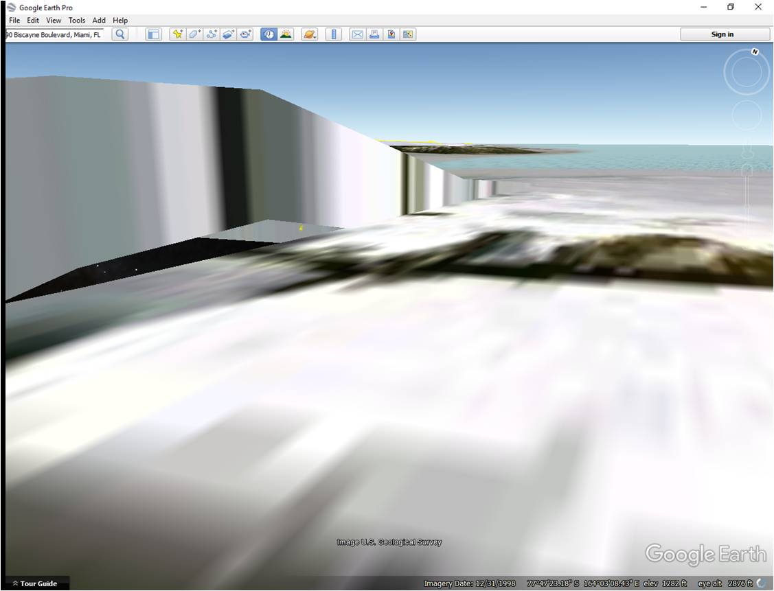
Looks like they tried to paint a square over something? Or maybe its just an innocent error in the software. Its odd to say the least!
As you approach the bottom entrance, it gets larger, pic below
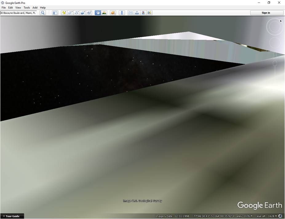
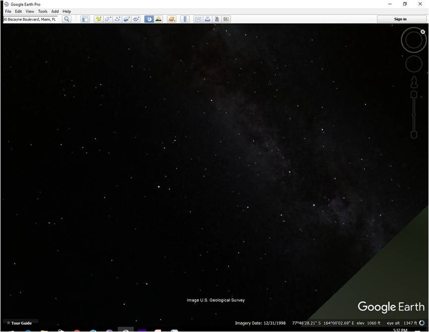
One more to illustrate whats inside of the crack – a starfield!!! Probably just the map of the google sky?
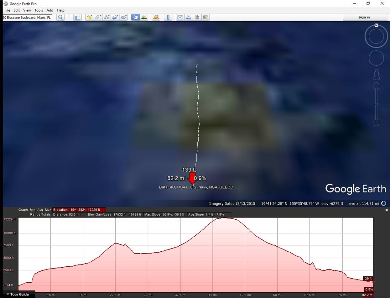
The next two pics show a waterfall that is 1600 feet tall (I included the elevation profile which shows height and width of the red lined section) then it flows uphill 1000 feet! Many dimensions in the Antarctic dont make sense at all. This stuff is huge! like thousands of feet high! Just play around with the elevation tools in google earth and the 3d images and you'll see what I mean.
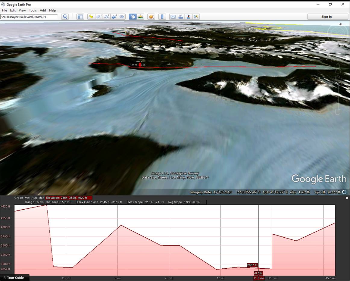
This one shows the same waterfall, but from different angle. Definitely go and check out the 3d rendering on the google earth download version – its pretty cool and fun to monkey around with!
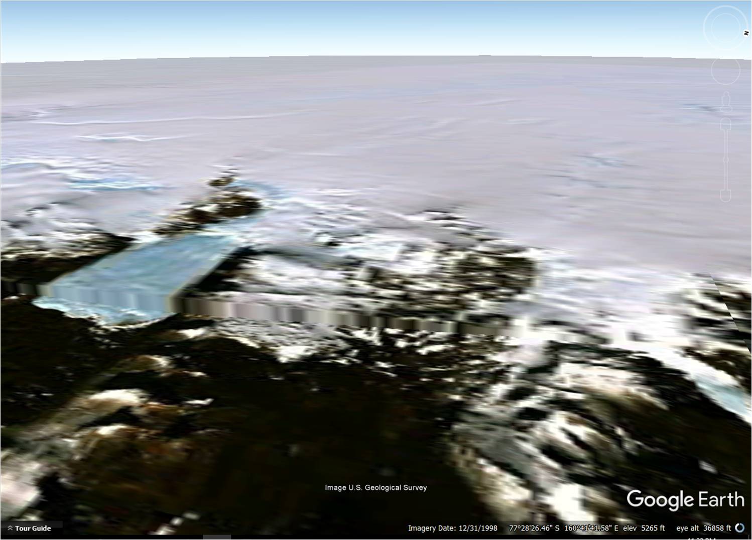
The next few show the creepy pyramid emanating light from the center of the antarctic circle (south pole location)
What's weird is when you go into the top of it, you can descend waaaaaay below the ice into a starfield like the one in the crack above. Its bizarre! But again I think it might just be attributed to glitchy software. When I ponder it, it seems they are trying to render out whats actually there. Its just a sorta weird way to do it if you asked me!
Seems like google likes to brag about how great they are at capturing images – if you’ve seen the video commercial online they claim they use airplanes, hot air balloons, and even kites to get the right imaging for google maps. We’ve had picture surveillance from U2 spy planes since the 50s. Not sure I buy the argument that the south pole is just too difficult for satellites to be able to navigate any decent imagery! They don’t want us to see whats there – that’s pretty obvious.
This last series is the strangest…
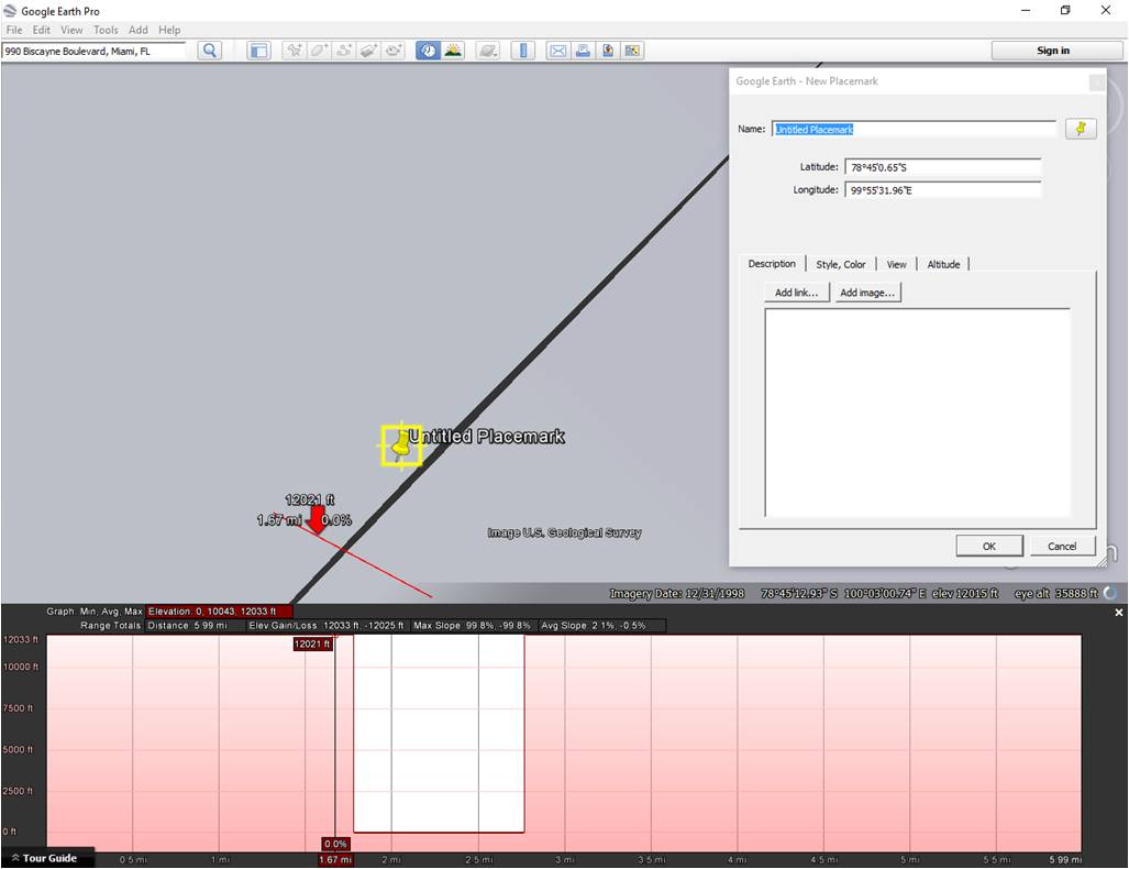
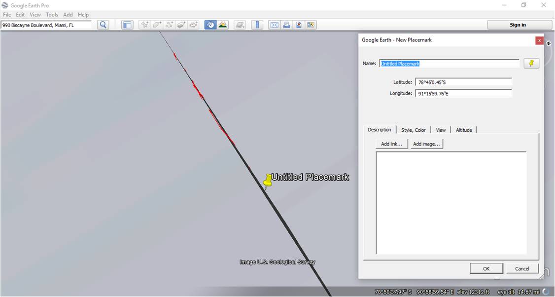
I found this glitch looking for various entry points from shoreline across the Antarctic plains to plan an expedition. When I kept seeing the same glitch popping up again and again, I zoomed in to get a better look at it. This picture shows the elevation profile that illustrates how deep it is. It shows a crevice going from the surface of the Antarctic, all the way down to sea level!!!
The mouse kept jumping around, trying to navigate this weird line that appears as a part of the pixilation of the area. This next pic is similar. It’s of a small section of the circle, revealing the black area that I kept seeing (the glitched out black area is the “chasm” part) You have to roll the screen around in the 3d mode at any spot on the circle and eventually you’ll catch a little black line that squirms around when you get at the correct angle to see it. Otherwise, you can just start by placing a single path across the black area, and you should see the mouse jump around on you as it attempts to navigate across the chasm. Its very odd the way it jumps around too – you just gotta try it to see what I mean. Hard to describe. It sorta shoots around real fast.
Here’s where it gets weird… when I traced the chasm it began to form the radius of a circle so I zoomed back out, drew a circle from the center of the freaky pyramid, and it lines up at… 777 miles radius almost exactly!
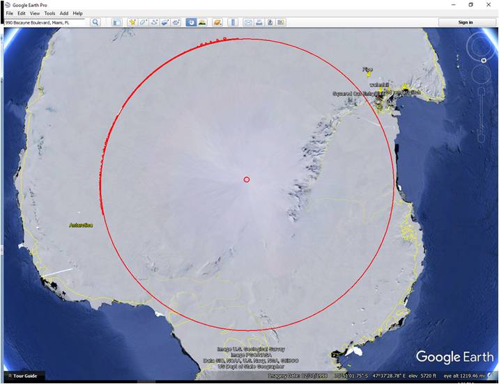
I’d think the 777 thing is a coincidence, but I know the conspiracy folks like that number so I thought I’d highlight it. If you have problems finding it, let me know and I’ll help with the navigation on the google earth. It’s a little wonky which is another reason I assume its just glitchy, you have to angle the thing just right to see the black part of the “chasm”.
Below is a series of pictures from the google-earth that show some pretty unusual things. I think it’s a new layer or something, because I don’t recall being able to see this stuff before on google earth. This one lets me go under the water and under the ice sheets too, like a submarine! Pretty cool, but I haven’t found the secret Nazi base… yet!!!!
The first three pics reveal a glitch of sorts near the coast with a starfield inside of it no less!
I call it the entrance to the underworld… LOL. It seems to be a glitch in the 3d that lets you see through to the otherside, which is the night sky.
Looks like they tried to paint a square over something? Or maybe its just an innocent error in the software. Its odd to say the least!
As you approach the bottom entrance, it gets larger, pic below
One more to illustrate whats inside of the crack – a starfield!!! Probably just the map of the google sky?
The next two pics show a waterfall that is 1600 feet tall (I included the elevation profile which shows height and width of the red lined section) then it flows uphill 1000 feet! Many dimensions in the Antarctic dont make sense at all. This stuff is huge! like thousands of feet high! Just play around with the elevation tools in google earth and the 3d images and you'll see what I mean.
This one shows the same waterfall, but from different angle. Definitely go and check out the 3d rendering on the google earth download version – its pretty cool and fun to monkey around with!
The next few show the creepy pyramid emanating light from the center of the antarctic circle (south pole location)
What's weird is when you go into the top of it, you can descend waaaaaay below the ice into a starfield like the one in the crack above. Its bizarre! But again I think it might just be attributed to glitchy software. When I ponder it, it seems they are trying to render out whats actually there. Its just a sorta weird way to do it if you asked me!
Seems like google likes to brag about how great they are at capturing images – if you’ve seen the video commercial online they claim they use airplanes, hot air balloons, and even kites to get the right imaging for google maps. We’ve had picture surveillance from U2 spy planes since the 50s. Not sure I buy the argument that the south pole is just too difficult for satellites to be able to navigate any decent imagery! They don’t want us to see whats there – that’s pretty obvious.
This last series is the strangest…
I found this glitch looking for various entry points from shoreline across the Antarctic plains to plan an expedition. When I kept seeing the same glitch popping up again and again, I zoomed in to get a better look at it. This picture shows the elevation profile that illustrates how deep it is. It shows a crevice going from the surface of the Antarctic, all the way down to sea level!!!
The mouse kept jumping around, trying to navigate this weird line that appears as a part of the pixilation of the area. This next pic is similar. It’s of a small section of the circle, revealing the black area that I kept seeing (the glitched out black area is the “chasm” part) You have to roll the screen around in the 3d mode at any spot on the circle and eventually you’ll catch a little black line that squirms around when you get at the correct angle to see it. Otherwise, you can just start by placing a single path across the black area, and you should see the mouse jump around on you as it attempts to navigate across the chasm. Its very odd the way it jumps around too – you just gotta try it to see what I mean. Hard to describe. It sorta shoots around real fast.
Here’s where it gets weird… when I traced the chasm it began to form the radius of a circle so I zoomed back out, drew a circle from the center of the freaky pyramid, and it lines up at… 777 miles radius almost exactly!
I’d think the 777 thing is a coincidence, but I know the conspiracy folks like that number so I thought I’d highlight it. If you have problems finding it, let me know and I’ll help with the navigation on the google earth. It’s a little wonky which is another reason I assume its just glitchy, you have to angle the thing just right to see the black part of the “chasm”.
a reply to: androal
You can put all of this in your original (non-introduction) thread.
www.abovetopsecret.com...
You can put all of this in your original (non-introduction) thread.
www.abovetopsecret.com...
a reply to: Phage
Yeah... I tried. I had to go to an event after I posted that earlier today. I just got home and typed up the newer one. This is the flag I get when I try to edit that post:
You have exceeded the maximum window of 4 hours allowed to edit your post.
Can I just delete it?
Yeah... I tried. I had to go to an event after I posted that earlier today. I just got home and typed up the newer one. This is the flag I get when I try to edit that post:
You have exceeded the maximum window of 4 hours allowed to edit your post.
Can I just delete it?
Please try any 3d graphic suite and find chapter "mapping" in its manual. You will quickly find where are your anomalies coming from.
a reply to: JanAmosComenius
a reply to: JanAmosComenius
Yeah, like I said in the post. Most likely all attributed to mistakes made by programers, limitations of software, and admittedly, errors in perceptions and judgements on my part.
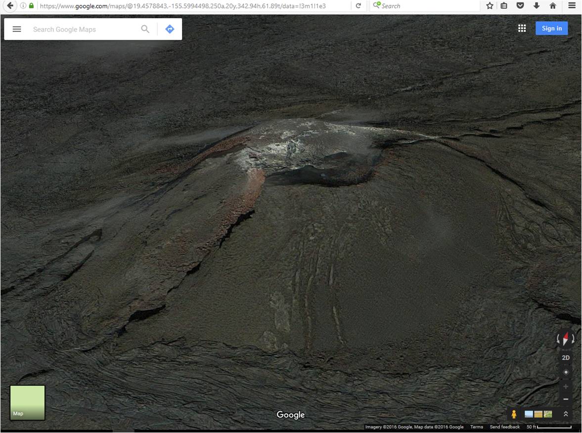
Do you know why google earth download version, which is advertised as having superior 3d capabilities not ordinarily available in the online version of google earth would have this data on Hawaii (see image below)
And yet the online version with its inferior technology renders the same island this way:
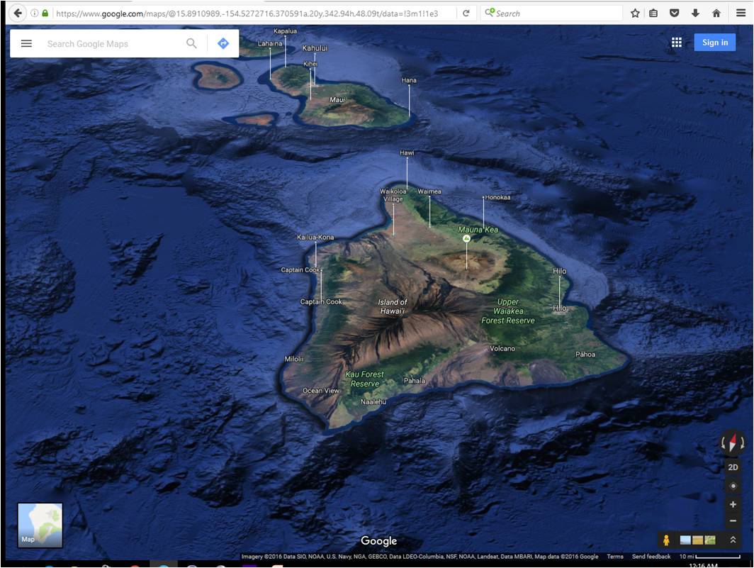
I mean look at the rendering of this small volcano on Hawaii, which is waaaayyy zoomed in relative to the above pic. The technology is killer.
At least I could get the elevation data from the blurry google earth rendering. Thats whats so crazy about the antarctic data - they tried to put in elevation data and its really odd and literally unreal.
And your going to honestly tell me that the same people who could read a newspaper from space in the eighties with SDI technology can’t seem to get it together to render Antarctica with at least something more than odd-ball pyramids and text book level academic excuses? This is NASA and the best funded best in the industry/world who you are talking about. Google is no slouch when it comes to 3d mapping capabilities (per image above).
They can read the date off a penny from space, and tell me precisely where I am, within 3 meters of accuracy, just about anywhere on the planet (probably even parts of Antarctica) just from the chip in my credit card and my phone.
And why would they even bother with any elevation data at all then? Why not admit they can't do it (believe me, they can) and make the whole thing flat? I mean, did you even look at the rendering of Antarctica? Its pretty amazing how far it is from reality, and yet how apparent it is that an effort is being made to render it.
I think they have legitimate reasons to hide sections of Antarctica and occasionally something goes awry, and it gets bungled. Even the military, NASA, and the best and brightest at google should be afforded some latitude. The antarctic thing is still a fail in my book.
a reply to: JanAmosComenius
Yeah, like I said in the post. Most likely all attributed to mistakes made by programers, limitations of software, and admittedly, errors in perceptions and judgements on my part.
Do you know why google earth download version, which is advertised as having superior 3d capabilities not ordinarily available in the online version of google earth would have this data on Hawaii (see image below)
And yet the online version with its inferior technology renders the same island this way:
I mean look at the rendering of this small volcano on Hawaii, which is waaaayyy zoomed in relative to the above pic. The technology is killer.
At least I could get the elevation data from the blurry google earth rendering. Thats whats so crazy about the antarctic data - they tried to put in elevation data and its really odd and literally unreal.
And your going to honestly tell me that the same people who could read a newspaper from space in the eighties with SDI technology can’t seem to get it together to render Antarctica with at least something more than odd-ball pyramids and text book level academic excuses? This is NASA and the best funded best in the industry/world who you are talking about. Google is no slouch when it comes to 3d mapping capabilities (per image above).
They can read the date off a penny from space, and tell me precisely where I am, within 3 meters of accuracy, just about anywhere on the planet (probably even parts of Antarctica) just from the chip in my credit card and my phone.
And why would they even bother with any elevation data at all then? Why not admit they can't do it (believe me, they can) and make the whole thing flat? I mean, did you even look at the rendering of Antarctica? Its pretty amazing how far it is from reality, and yet how apparent it is that an effort is being made to render it.
I think they have legitimate reasons to hide sections of Antarctica and occasionally something goes awry, and it gets bungled. Even the military, NASA, and the best and brightest at google should be afforded some latitude. The antarctic thing is still a fail in my book.
a reply to: JanAmosComenius
Yes, and that's why 98 different country's have established scientific non-military stations costing hundreds of billions of dollars with cutting edge technology so advanced they wont even let you see aerial pictures of it?
To perform scientific studies on penguins and rocks?
Wow.
Yes, and that's why 98 different country's have established scientific non-military stations costing hundreds of billions of dollars with cutting edge technology so advanced they wont even let you see aerial pictures of it?
To perform scientific studies on penguins and rocks?
Wow.
a reply to: androal
Have you actually looked at the stations?
Have you actually looked at the stations?
Actually, the majority of it has to do with climate studies. Though there may be some geology and ecological stuff going on too.
To perform scientific studies on penguins and rocks?
edit on 10/6/2016 by Phage because: (no reason given)
a reply to: Phage
a reply to: Phage
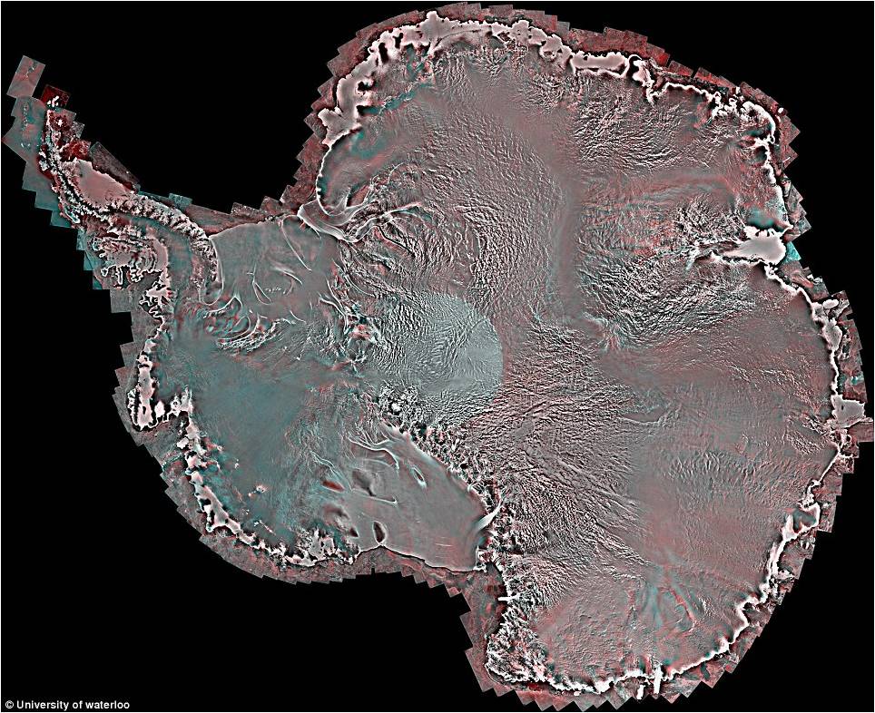
Yes, and here is how students at The University of Waterloo rendered the data. This image was published in Science Daily in 2014.
Science Daily
a reply to: Phage
Yes, and here is how students at The University of Waterloo rendered the data. This image was published in Science Daily in 2014.
Science Daily
a reply to: androal
That's a good start.
What is the resolution of the DEM which Google uses for Antarctica?
What is the resolution of the DEM which Google uses for Hawaii island?
Important information for anomaly hunters.
That's a good start.
What is the resolution of the DEM which Google uses for Antarctica?
What is the resolution of the DEM which Google uses for Hawaii island?
Important information for anomaly hunters.
edit on 10/6/2016 by Phage because: (no reason given)
a reply to: Phage
Yes, the summary of the agreement is below:
A twelve nation agreement to protect the peaceful status of the Antarctic Continent. It bans the following from Antarctica:
establishment of military bases
military maneuvers
stationing or testing of any type of weapon
nuclear explosion
radioactive waste disposal.
The Treaty provides each party with the right to full on-site and aerial inspection of all Antarctic installations in order to verify these provisions. On June 23, 1961, the treaty entered into force.
Science projects. That's all they do there. I read the rules. And with all the aerial inspections we've done as USA world police to make sure everyone is playing by the rules, we have the beautifully rendered images we now see on google earth.
a reply to: Phage
NSDIC
NSIDC Data was 1km back in 2003
vterrain.org
Hawaii was 10m or 5m depending on the source (NEXTMap) offers 5m data for a price...
Maybe those science stations conducting research on the rocks and the penguins with billions of dollars could lend a hand and snap a few Polaroids for us?
I measured the DEM of the google image at 2km surrounding the pole, wih significant improvement at the shoreline, where imaging rivals that of the rest of google, depending on location.
Its very location specific and inconsistently applied, with large sections showing vast increases and decreases over time, and depending on version.
a reply to: androal
Big difference, huh?
NSIDC Data was 1km back in 2003
Hawaii was 10m or 5m depending on the source (NEXTMap) offers 5m data for a price...
Big difference, huh?
Cool. But it seems that you are confusing the DEM with the imagery which overlays it. Want some fun? Check out the north pole. Projecting flat images on a round surface always becomes problematic at some point. (2 points, actually)
I measured the DEM of the google image at 2km surrounding the pole, wih significant improvement at the shoreline, where imaging rivals that of the rest of google, depending on location.
edit on 10/6/2016 by Phage because: (no reason given)
a reply to: Phage
Yeah, that's very helpful info - thank you!
It looks like its done tile by tile?
That would explain why the large sections go up and down in res, but not over time...
Do you know why they would bother to smudge out or use very low res images at different parts of the Island? This is an oddity thats bothersome. Especially when a higher res version of a tile was there one day and then replaced with a lower res one the next. Doesn't make sense why they wouldn't default to the highest available and consistently apply the standard. What am I missing?
And why does google earth suck so bad in certain areas, and make good on their claim to offer a superior product in others? (like Hawaii)
I'm a bit dense when it comes down to it... not following your train on the North Pole fun. Sounds fun, what is it? And wheres the Ice cap for the northern polar region on google earth? They have it overlayed on the south pole, but not the north.
I really want a hi res Hawaii map, as I'm planning an ascent there next year and it would really help my trip planning.
edit on 6-10-2016 by
androal because: (no reason given)
edit on 6-10-2016 by androal because: (no reason given)
a reply to: androal
magis.manoa.hawaii.edu...
Google tends to use the highest resolution images available, both aerial and satellite. At the poles both aerial and satellite imagery is spotty. Try this, find an area with pretty good resolution and use the timeline feature to look at earlier imagery for the same area, you will see that the older stuff is not as good as the newer stuff.
Do you know why they would bother to smudge out or use very low res images at different parts of the Island?
You could always get a topo map. Actually more useful for your purposes.
I really want a hi res Hawaii map, as I'm planning an ascent there next year and it would really help my trip planning.
magis.manoa.hawaii.edu...
edit on 10/6/2016 by Phage because: (no reason given)
new topics
-
Liberal Madness and the Constitution of the United States
US Political Madness: 3 hours ago -
New York Governor signs Climate Law that Fines Fossil Fuel Companies
US Political Madness: 11 hours ago
top topics
-
New York Governor signs Climate Law that Fines Fossil Fuel Companies
US Political Madness: 11 hours ago, 14 flags -
Meta Llama local AI system is scary good
Science & Technology: 16 hours ago, 6 flags -
Liberal Madness and the Constitution of the United States
US Political Madness: 3 hours ago, 2 flags
active topics
-
Liberal Madness and the Constitution of the United States
US Political Madness • 4 • : network dude -
‘Something horrible’: Somerset pit reveals bronze age cannibalism
Ancient & Lost Civilizations • 27 • : Xtrozero -
Parker Solar Probe is about to Kiss the Sun
Space Exploration • 9 • : AdultMaleHumanUK -
Putin Compares Himself to Jesus Promoting Traditional Values Against the Satanic West
Mainstream News • 80 • : UpIsNowDown2 -
Meta Llama local AI system is scary good
Science & Technology • 27 • : ArMaP -
New York Governor signs Climate Law that Fines Fossil Fuel Companies
US Political Madness • 17 • : DAVID64 -
This is why ALL illegals who live in the US must go
Social Issues and Civil Unrest • 25 • : network dude -
The Mystery Drones and Government Lies --- Master Thread
Political Conspiracies • 155 • : 38181 -
Elon Musk futurist?
Dreams & Predictions • 15 • : Flyingclaydisk -
UK Borders are NOT Secure!
Social Issues and Civil Unrest • 9 • : gortex