It looks like you're using an Ad Blocker.
Please white-list or disable AboveTopSecret.com in your ad-blocking tool.
Thank you.
Some features of ATS will be disabled while you continue to use an ad-blocker.

Look out Texas: Severe outbreak and torrential flooding on it's way.
page: 1share:
Good evening or good morning ATS,
I have been considering whether i would make this thread regarding tomorrow and the potential that exists for a significant tornado outbreak/ severe weather event, that hinges on what occurs tonight and the amount of instability and lift available tomorrow, and while debating that, in fact a tornado was reported and significant damage has occurred just west of Dallas(which certainly indicates the amount of spin in the atmosphere), our thoughts and concerns are immediately directed to the palo pinto/ parker counties where damage is being reported, hopefully no lives have been lost
So lets get right to it.
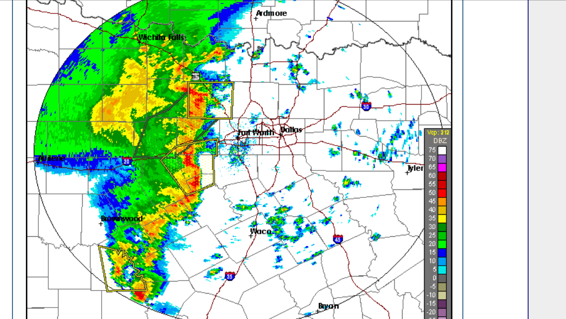
Tonight an uptick in convection should continue mainly to the north west of the Dallas area( spreading from south west to north east which means Dallas may be effected) According to the latest high resolution model (HRRR: high resolution rapid refresh - which updates every hour ) the current convection to the northwest will quickly move out of Texas, and followed by a more significant squall line effecting the greater Dallas area around 8am. ( bowing segments are indicated which would represent a straight line wind damage potential, in morning rush hour)
If this occurs, subsidence and stabilization of the atmosphere will follow. However, that is not to say that an outbreak will not occur Tuesday afternoon as all the ingredients will be there, withstanding a strong lifting mechanism. If breaks in the clouds form or there is enough time for the atmosphere to recover (less subsidence) than Dallas metro area could be in for yet another direct hit.
A word from the National Weather Service regarding the potentials:
So, if any storm can initiate (Tuesday 12pm - 9pm) the conditions are ripe for severe weather and tornadoes , and secondly and not any less of a threat flooding where 3 - 5 inches of rain can be expected East of I-35 with the majority falling Tuesday night through Wednesday(where less of a severe weather threat exists in terms of tornadoes or hail transitioning to flooding concern), with that said keep your eyes to the sky and everyone be safe. if you wish to follow storm chasers via live stream here is a great place to do so. I will update this thread
Storm chaser live stream
I have been considering whether i would make this thread regarding tomorrow and the potential that exists for a significant tornado outbreak/ severe weather event, that hinges on what occurs tonight and the amount of instability and lift available tomorrow, and while debating that, in fact a tornado was reported and significant damage has occurred just west of Dallas(which certainly indicates the amount of spin in the atmosphere), our thoughts and concerns are immediately directed to the palo pinto/ parker counties where damage is being reported, hopefully no lives have been lost
So lets get right to it.
Tonight an uptick in convection should continue mainly to the north west of the Dallas area( spreading from south west to north east which means Dallas may be effected) According to the latest high resolution model (HRRR: high resolution rapid refresh - which updates every hour ) the current convection to the northwest will quickly move out of Texas, and followed by a more significant squall line effecting the greater Dallas area around 8am. ( bowing segments are indicated which would represent a straight line wind damage potential, in morning rush hour)
If this occurs, subsidence and stabilization of the atmosphere will follow. However, that is not to say that an outbreak will not occur Tuesday afternoon as all the ingredients will be there, withstanding a strong lifting mechanism. If breaks in the clouds form or there is enough time for the atmosphere to recover (less subsidence) than Dallas metro area could be in for yet another direct hit.
A word from the National Weather Service regarding the potentials:
FORECAST SOUNDINGS
SUGGEST THAT A RATHER UNPERTURBED UNSTABLE AIRMASS WILL BE IN
PLACE ACROSS MOST OF THE AREA. IT SHOULD ALSO BE VERY WEAKLY
CAPPED. THIS SEEMS VERY FAVORABLE FOR A SIGNIFICANT SEVERE
THREAT...ALTHOUGH WIND PROFILES BACK WEAKLY IN THE MID LEVELS
LIKELY INDICATING SOME WEAK SUBSIDENCE IN THE WAKE OF THE EARLY
MORNING ACTIVITY. IF THIS IS IN FACT THE CASE...THEN IT MAY BE A
QUIET DAY...ALTHOUGH HUMID AND WARM. IF THE SUBSIDENCE DOES NOT
EXIST AND WE HAVE ANY LIFT AT ALL...THEN SURFACE BASED CONVECTION
COULD DEVELOP AND BECOME SEVERE WITH ALL MODES OF SEVERE WEATHER
POSSIBLE. UNFORTUNATELY...WE WILL LIKELY HAVE TO WAIT TO SEE WHAT
IMPACT THE OVERNIGHT CONVECTION HAS ON THE AIRMASS AND POSSIBLY
ANY DATA FROM 12 OR 18Z SOUNDINGS TOMORROW CAN OFFER.
So, if any storm can initiate (Tuesday 12pm - 9pm) the conditions are ripe for severe weather and tornadoes , and secondly and not any less of a threat flooding where 3 - 5 inches of rain can be expected East of I-35 with the majority falling Tuesday night through Wednesday(where less of a severe weather threat exists in terms of tornadoes or hail transitioning to flooding concern), with that said keep your eyes to the sky and everyone be safe. if you wish to follow storm chasers via live stream here is a great place to do so. I will update this thread
Storm chaser live stream
whew i was worried it was raining herpes or something. i do hope all are safe and prepared for the whopper heading in. yall be careful.
edit on 7-3-2016 by CaDreamer because: (no reason given)
TVNweather Live Storm Chasing
Here is a link to watch the live storm chasers in Texas right now. (Sorry I didn't see the link at the bottom of OP-TechniXcality's post)
Here is a link to watch the live storm chasers in Texas right now. (Sorry I didn't see the link at the bottom of OP-TechniXcality's post)
edit on 3/7/2016 by Martin75 because: (no reason given)
Crap!! My sister, oldest son and assorted nieces and nephews are in that area. Thankfully, my sister is a bit paranoid about storms, thanks to being
in a tornado when we were much younger. [ I still stand outside watching severe thunderstorms ]
This is off topic as all hell, but,TechniXcality, if that's your real face, you bear an uncanny
resemblance to Robert Sean Leonard, who played Dr James Wilson on "House"-

This is off topic as all hell, but,TechniXcality, if that's your real face, you bear an uncanny
resemblance to Robert Sean Leonard, who played Dr James Wilson on "House"-
a reply to: DAVID64
I hope they stay safe and i am glad to hear they are weather minded or your sister is for that matter . I will update soon though i may of started the thread to early but its always a guessing game i just wanted the potentials to be made clear.
Yes sir, that's me, i have got Gordon levitt, and an Irish singer,now from house
Was just living in that very area last year at this time when we got hammered......
I hear my town has debris all over it......lol glad im back up north now!
I hear my town has debris all over it......lol glad im back up north now!
Looks like it will hit us around 3 am Wednesday morning. Why does this severe stuff always seem to happen in the wee hours? I lay awake all night
listening for the tornado. Bugger
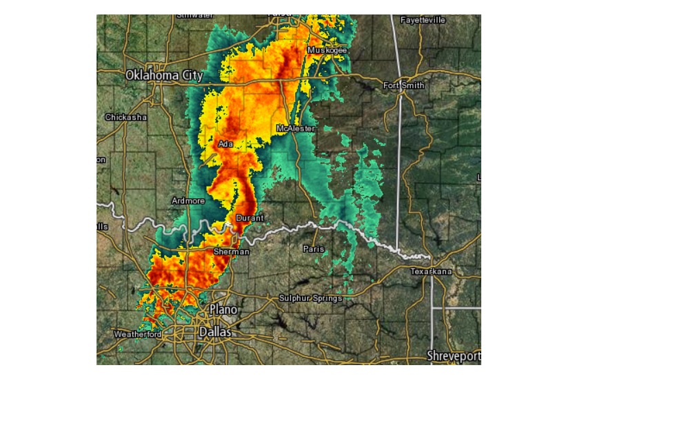
Sherman and Durant look like they are getting pounded right now.
Our local weatherman said that some places can expect up to 10 inches of rain. Holy crap
Sherman and Durant look like they are getting pounded right now.
Our local weatherman said that some places can expect up to 10 inches of rain. Holy crap
edit on 3/7/2016 by Neysa because: (no reason
given)

Looks like March and severe weather season have arrived.
Time to begin the age old tradition of duck and cover in the plains.
Everyone stay safe and aware of your local skies.
Time to begin the age old tradition of duck and cover in the plains.
Everyone stay safe and aware of your local skies.
I just hope it avoids the Garland/Rowlett area. After the big tornado we had over Christmas these folks don't need another one coming through!!! I
am in Frisco (far north Dallas suburb) but my best friend lives in Rowlett and she's terrified it will happen again.
And I hate hail!! I've already replaced my windshield and don't want to do it again!
And I hate hail!! I've already replaced my windshield and don't want to do it again!
a reply to: texasgirl
Quick update though this may be long winded..
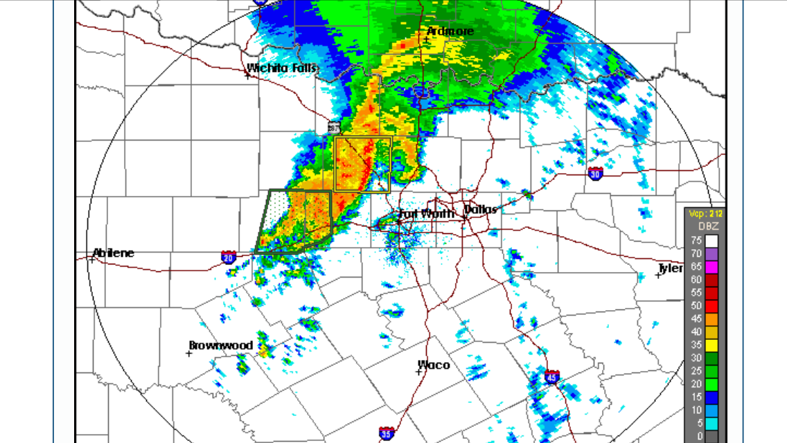
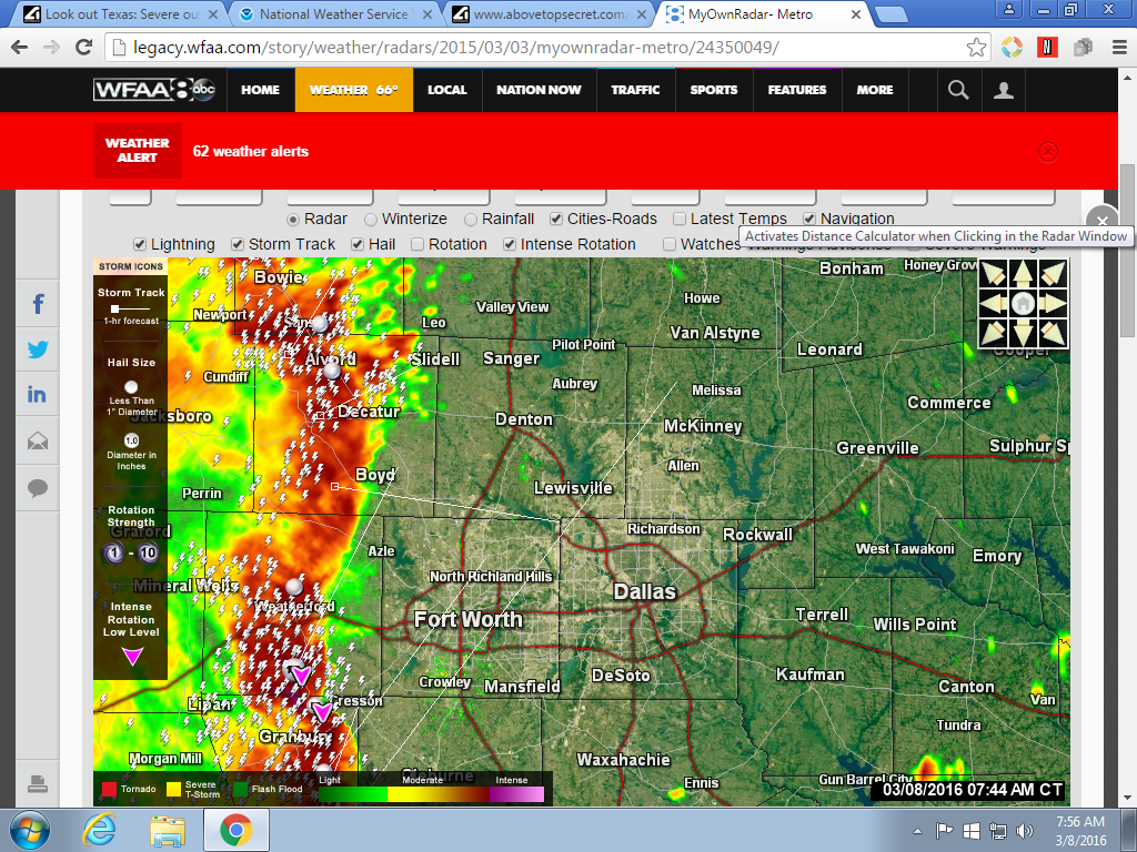
The mcs/quasi squall line with embedded severe thunderstorms is making its way NNE across north central Texas this morning. All of the DFW metro should get some rain with this feature this morning,(possibly severe thunderstorms, including tornadoes) here is a picture of radar:
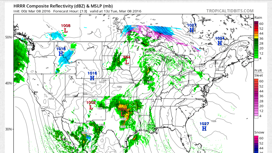
The primary concern immediately shifts to this evening where cape values of 3000 - 4000 K/G of surface instability will be available. this kind of instability would favor long track wedge tornadoes and baseball sized hail, we should hope that this mornings activity circumvents development this afternoon, if it does not and the HRRR model versify s than we could be looking at a very active afternoon and quite dangerous. here is a picture of what the HRRR is suggesting
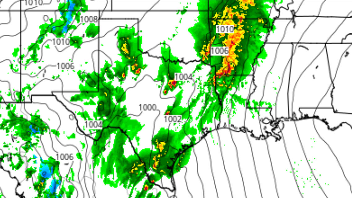
Which shows super cell initiation just west of Dallas tracking right over. here is what NWS (national weather service) has to say about this afternoon.
Also a tornado warning has just been issued, THIS IS MOVING INTO TARRANT COUNTY TAKE COVER
Quick update though this may be long winded..
The mcs/quasi squall line with embedded severe thunderstorms is making its way NNE across north central Texas this morning. All of the DFW metro should get some rain with this feature this morning,(possibly severe thunderstorms, including tornadoes) here is a picture of radar:
The primary concern immediately shifts to this evening where cape values of 3000 - 4000 K/G of surface instability will be available. this kind of instability would favor long track wedge tornadoes and baseball sized hail, we should hope that this mornings activity circumvents development this afternoon, if it does not and the HRRR model versify s than we could be looking at a very active afternoon and quite dangerous. here is a picture of what the HRRR is suggesting
Which shows super cell initiation just west of Dallas tracking right over. here is what NWS (national weather service) has to say about this afternoon.
BY THIS AFTERNOON THE SHORTWAVE RESPONSIBLE FOR THIS MORNING/S
RAIN WILL BE MOVING OUT OF THE REGION AND SUBSIDENCE AND DRIER AIR
IN THE 700-850MB LAYER WILL SPREAD IN FROM THE SOUTHWEST. THIS
SUBSIDENCE MAY EVEN BE ENOUGH TO RESULT IN SOME CLEARING SKIES
ACROSS WESTERN AND SOUTHERN AREAS. HIGH TEMPS WOULD RESPOND TO THE
SUNSHINE AND COULD REACH THE MID 70S TO 80 DEGREES ACROSS THIS
PART OF THE CWA. JUST LOW TO MID 70S ARE EXPECTED ELSEWHERE.
THE AFTERNOON FORECAST IS UNCERTAIN DUE TO CONFLICTING SIGNALS IN
THE ATMOSPHERE. ON ONE HAND...RATHER STRONG UPPER LEVEL SUBSIDENCE
ON THE SYNOPTIC SCALE IS EXPECTED AND IT WOULD CERTAINLY SUPPRESS
CONVECTIVE POTENTIAL THIS AFTERNOON...BUT IT WOULD BUILD UP A
TREMENDOUS AMOUNT OF SURFACE BASED INSTABILITY. MODEL GUIDANCE IS
UNANIMOUSLY SHOWING CAPE VALUES OF AT LEAST 2000 J/KG WITH SOME
INDICATING 3500 J/KG. THIS INSTABILITY WOULD BE UNCAPPED...BUT IF
THE SUBSIDENCE IS DOMINANT...CONVECTION WOULD HAVE A TOUGH TIME
FORMING. ON THE OTHER HAND...SOME OF THE HI-RES GUIDANCE SHOWS
MESOSCALE FEATURES WHICH COULD RESULT IN LOCALIZED UPWARD FORCING
THAT WOULD ALLOW THUNDERSTORMS TO DEVELOP. ONE OF THESE MAY BE A
DRY LINE THAT ACTUALLY MOVES UP FROM THE SOUTH FROM THE HILL
COUNTRY INTO THE SOUTHWEST ZONES TODAY. THIS IS CERTAINLY NOT A
NORMAL OCCURRENCE HERE AND IS ATTRIBUTED TO THE UNUSUAL SOUTHERLY
TRACK OF THE UPPER LOW. THE SECOND FEATURE OF INTEREST IS FORECAST
BY THE RAP...WHICH SUGGESTS THIS MORNING/S CONVECTION WILL LEAVE
AN OUTFLOW BOUNDARY SOMEWHERE ACROSS THE NORTHWEST ZONES. STRONG
SOUTH WINDS IN THE LOW LEVELS WOULD INDUCE STRONG WARM ADVECTION
AND LIFT OVER THE TOP OF THIS BOUNDARY AND COULD RESULT IN
CONVECTIVE INITIATION. IF ANY STORMS DEVELOP ALL FACETS OF SEVERE
WEATHER WOULD BE POSSIBLE DUE TO THE HIGH INSTABILITY AND DEEP
SHEAR. THE MOST LIKELY REGION WHERE AFTERNOON STORMS WOULD DEVELOP
IS WEST OF I-35...BUT DUE TO LOW CONFIDENCE/COVERAGE WILL KEEP
AFTERNOON POPS AT 30 PERCENT OR LESS.
Also a tornado warning has just been issued, THIS IS MOVING INTO TARRANT COUNTY TAKE COVER
Tornado Warning
TORNADO WARNING
TXC221-251-367-439-081415-
/O.NEW.KFWD.TO.W.0002.160308T1346Z-160308T1415Z/
BULLETIN - EAS ACTIVATION REQUESTED
TORNADO WARNING
NATIONAL WEATHER SERVICE FORT WORTH TX
746 AM CST TUE MAR 8 2016
THE NATIONAL WEATHER SERVICE IN FORT WORTH HAS ISSUED A
* TORNADO WARNING FOR...
NORTHEASTERN HOOD COUNTY IN NORTH CENTRAL TEXAS...
SOUTHEASTERN PARKER COUNTY IN NORTH CENTRAL TEXAS...
NORTHWESTERN JOHNSON COUNTY IN NORTH CENTRAL TEXAS...
SOUTHWESTERN TARRANT COUNTY IN NORTH CENTRAL TEXAS...
* UNTIL 815 AM CST
* AT 745 AM CST...A SEVERE THUNDERSTORM CAPABLE OF PRODUCING A
TORNADO WAS LOCATED 8 MILES NORTHEAST OF GRANBURY...MOVING
NORTHEAST AT 40 MPH.
*A SECOND STORM WAS LOCATED ABOUT 10 MILES SOUTH OF
WEATHERFORD...ALSO MOVING NORTHEAST AT 40 MPH.
HAZARD...TORNADO.
SOURCE...RADAR INDICATED ROTATION.
IMPACT...FLYING DEBRIS WILL BE DANGEROUS TO THOSE CAUGHT WITHOUT
SHELTER. MOBILE HOMES WILL BE DAMAGED OR DESTROYED.
DAMAGE TO ROOFS...WINDOWS...AND VEHICLES WILL OCCUR. TREE
DAMAGE IS LIKELY.
* THIS DANGEROUS STORM WILL BE NEAR...
GODLEY AROUND 755 AM CST.
BENBROOK AND CROWLEY AROUND 815 AM CST.
OTHER LOCATIONS IMPACTED BY THIS TORNADIC THUNDERSTORM INCLUDE
ANNETTA NORTH AND ANNETTA SOUTH.
THIS INCLUDES THE FOLLOWING INTERSTATES...
INTERSTATE 20 BETWEEN MILE MARKERS 412 AND 428.
INTERSTATE 30 BETWEEN MILE MARKERS 1 AND 5.
INTERSTATE 820 BETWEEN MILE MARKERS 1 AND 3.
PRECAUTIONARY/PREPAREDNESS ACTIONS...
TAKE COVER NOW! MOVE TO A BASEMENT OR AN INTERIOR ROOM ON THE LOWEST
FLOOR OF A STURDY BUILDING. AVOID WINDOWS. IF YOU ARE OUTDOORS...IN A
MOBILE HOME...OR IN A VEHICLE...MOVE TO THE CLOSEST SUBSTANTIAL
SHELTER AND PROTECT YOURSELF FROM FLYING DEBRIS.
&&
LAT...LON 3283 9755 3255 9736 3239 9768 3267 9789
TIME...MOT...LOC 1345Z 238DEG 33KT 3251 9766
TORNADO...RADAR INDICATED
HAIL...
I have to leave the house at 9:45. This stinks! Am I going to get caught in this? I am in the Frisco/McKinney area.
Be safe you crazy Texans, take them huge hats off before going outside.
But seriously, be safe.
But seriously, be safe.
Reports of mobile homes turned over in Toller. That's southwest Ft Worth area.
update: People trapped inside trailers and 3 injured so far.
update: People trapped inside trailers and 3 injured so far.
edit on 8-3-2016 by texasgirl because: (no reason given)
a reply to: TechniXcality
Thank you, TechniX- After those cars that were tossed off the freeway in December I get nervous about driving in this weather.
Thank you, TechniX- After those cars that were tossed off the freeway in December I get nervous about driving in this weather.
new topics
-
For Votes - President BIDEN Opens ObamaCare Health Ins to Illegal Aliens Eff Nov 1st 2024.
2024 Elections: 1 hours ago -
EPA sues San Francisco for dumping billions of gallons of sewage into Pacific Ocean
US Political Madness: 2 hours ago -
Prophets versus priests; - Getting God's help
Religion, Faith, And Theology: 4 hours ago -
UN Estimates Rebuilding Gaza Will Cost Up To 40 Billion Dollars
Middle East Issues: 6 hours ago -
Study Finds The More Covid Vaccine Doses You Have, the More Likely You Are to Get Covid
Medical Issues & Conspiracies: 6 hours ago -
Wounded Orangutan seen using a Plant as Medicine for the First Time
Fragile Earth: 7 hours ago -
Democratic Rep. Henry Cuellar and wife indicted on federal bribery charges
US Political Madness: 7 hours ago -
An AI-controlled fighter jet took the Air Force leader for a historic ride
Military Projects: 7 hours ago -
SEC shuts down Trump Media auditor, BF Borgers, over fraud
Mainstream News: 8 hours ago -
Farmers jailed without due process
General Conspiracies: 8 hours ago
top topics
-
Wounded Orangutan seen using a Plant as Medicine for the First Time
Fragile Earth: 7 hours ago, 13 flags -
Study Finds The More Covid Vaccine Doses You Have, the More Likely You Are to Get Covid
Medical Issues & Conspiracies: 6 hours ago, 13 flags -
Farmers jailed without due process
General Conspiracies: 8 hours ago, 8 flags -
EPA sues San Francisco for dumping billions of gallons of sewage into Pacific Ocean
US Political Madness: 2 hours ago, 6 flags -
UN Estimates Rebuilding Gaza Will Cost Up To 40 Billion Dollars
Middle East Issues: 6 hours ago, 6 flags -
Democratic Rep. Henry Cuellar and wife indicted on federal bribery charges
US Political Madness: 7 hours ago, 6 flags -
Poll - Catholic Support Swings to Trump By Significant Margin
2024 Elections: 12 hours ago, 5 flags -
SEC shuts down Trump Media auditor, BF Borgers, over fraud
Mainstream News: 8 hours ago, 5 flags -
For Votes - President BIDEN Opens ObamaCare Health Ins to Illegal Aliens Eff Nov 1st 2024.
2024 Elections: 1 hours ago, 4 flags -
An AI-controlled fighter jet took the Air Force leader for a historic ride
Military Projects: 7 hours ago, 2 flags
active topics
-
Candidate TRUMP Now Has Crazy Judge JUAN MERCHAN After Him - The Stormy Daniels Hush-Money Case.
Political Conspiracies • 1134 • : Zanti Misfit -
Study Finds The More Covid Vaccine Doses You Have, the More Likely You Are to Get Covid
Medical Issues & Conspiracies • 19 • : kkRon1kk -
For Votes - President BIDEN Opens ObamaCare Health Ins to Illegal Aliens Eff Nov 1st 2024.
2024 Elections • 7 • : theatreboy -
An Implausible New Electoral Process?
Political Ideology • 31 • : CriticalStinker -
Poll - Catholic Support Swings to Trump By Significant Margin
2024 Elections • 27 • : fringeofthefringe -
SEC shuts down Trump Media auditor, BF Borgers, over fraud
Mainstream News • 44 • : ByeByeAmericanPie -
Democratic Rep. Henry Cuellar and wife indicted on federal bribery charges
US Political Madness • 19 • : theatreboy -
EPA sues San Francisco for dumping billions of gallons of sewage into Pacific Ocean
US Political Madness • 13 • : CataclysmicRockets -
Doctors Predict Epidemic of Prion Brain Diseases From mRna Jab
Health & Wellness • 63 • : nugget1 -
What is "Genocide"?
US Political Madness • 51 • : cherokeetroy