It looks like you're using an Ad Blocker.
Please white-list or disable AboveTopSecret.com in your ad-blocking tool.
Thank you.
Some features of ATS will be disabled while you continue to use an ad-blocker.
13
share:


s this the lost city of the Kalahari?
Wind erosion has lead to an incredible discovery through google maps.
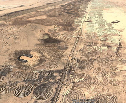
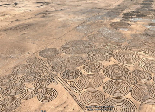
Comparable to the Nasca Lines in size, and even more impressive in intricacy, a potential massive lost city or site has been revealed in an area of the “verneukpan” an inhospitable area of salt flats in southern Africa .
For over a year now, a young determined Dutchman has been using Google earth to map the world’s ancient sites, very much a crowd-sourced project, with over 900 place markers so far of sites that are known about and links to Wikipedia articles about them.
Archeomaps is the brainchild of Jaimy Visser, who posted this image yesterday on his facebook page www.facebook.com/Archeomaps after Shaun Kirwen brought it to his attention.
Jaimy had found that in his research he was finding many unexplained circular structures around the globe and started project “Esthar” to try and map these as well, in the process he has found huge areas of desert with evidence of similar ancient civilizations around the globe though none quite as striking as these which bear resemblance to carvings at Knowth , Newgrange, Malta and various other prehistorical sites.
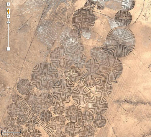
The complex in the image is over five square miles, with less striking patterns spread over around twenty square miles at least.
www.cosmostv.org...
I was doing some research on lost African iron aged civilizations in South Africa when I chanced on the above, the find was apparently made back in 2010 ,but the link above just recorded what was found, not who may have made them or why if anyone have info or even a guess pls chime in.
I'm fascinated by early man's use of the spiral, it seems to pop up everywhere.
I can't help but wonder if it was related to something awesome they witnessed happening in the sky.
I can't help but wonder if it was related to something awesome they witnessed happening in the sky.
Just wondering, are these furrows in the ground or stones placed to form spirals? Can't quite tell from the images, maybe a close up…
if furrows and thats salt, maybe they were collecting it? Or water catch basins?
if furrows and thats salt, maybe they were collecting it? Or water catch basins?
originally posted by: intrptr
Just wondering, are these furrows in the ground or stones placed to form spirals? Can't quite tell from the images, maybe a close up…
if furrows and thats salt, maybe they were collecting it? Or water catch basins?
Looks like stones.
originally posted by: Spider879
originally posted by: intrptr
Just wondering, are these furrows in the ground or stones placed to form spirals? Can't quite tell from the images, maybe a close up…
if furrows and thats salt, maybe they were collecting it? Or water catch basins?
Looks like stones.
The Nazca lines are sometimes stones, sometimes paths. Can't really tell without close ups.
Looking…
Further: According to some speculation here they could be mining furrows made to collect some mineral or ore, or an irrigation system…
edit on 28-1-2016 by intrptr because: Further:
It's MODERN. These are not ancient geoforms. In fact the claim is these were made in the past 6 years.
Google Earth Forums:
Hundreds of Spirals! The Verneukpan, South Africa


Contour trenchers break-up hard pans, trap rainfall, improve infiltration, and promote the rejuvenation
of resident grasses and the germination, emergence, and establishment of seeded grasses.
The only person making the claim this is an ancient city appears to be Graham Hancock - wrong as usual.
Edit to add: Why the spiral shapes? "A reason for cutting spirals over straight lines (which were used first) may be water retention in place. The pan is not absolutely flat, though very close to it, and very long linear features may let rainfall easily migrate to the lowest elevation along them. Spirals, on the other hand would tend to keep rainfall accumulations where they fall thereby eventually producing more widely distributed water to the water table."
Edit: fixed broken link
Google Earth Forums:
Hundreds of Spirals! The Verneukpan, South Africa


Contour trenchers break-up hard pans, trap rainfall, improve infiltration, and promote the rejuvenation
of resident grasses and the germination, emergence, and establishment of seeded grasses.
The only person making the claim this is an ancient city appears to be Graham Hancock - wrong as usual.
Edit to add: Why the spiral shapes? "A reason for cutting spirals over straight lines (which were used first) may be water retention in place. The pan is not absolutely flat, though very close to it, and very long linear features may let rainfall easily migrate to the lowest elevation along them. Spirals, on the other hand would tend to keep rainfall accumulations where they fall thereby eventually producing more widely distributed water to the water table."
Edit: fixed broken link
edit on 28-1-2016 by Blackmarketeer because: (no reason given)
a reply to: Blackmarketeer
Much thanks Blackmarketeer another salted site.. these guys really annoys me to no end..
Much thanks Blackmarketeer another salted site.. these guys really annoys me to no end..
Well there were a few clues these were not ancient - the roadway cutting right through the middle of them, and in the third photo posted, you can see
earlier straight furrows cut by farming yet these appear on top and much fresher. Posters on that site also mention these are not present in Google
Earth six years previously, and the notion wind erosion would so uniformly expose this entire field seems dubious at best. It shows you can't put any
faith in the fringe-science crowd, as it should have been obvious to them it was a modern creation - instead we get them linking it to "Adam's
Calendar," and "ancient lost cities."
originally posted by: Blackmarketeer
Well there were a few clues these were not ancient - the roadway cutting right through the middle of them, and in the third photo posted, you can see earlier straight furrows cut by farming yet these appear on top and much fresher. Posters on that site also mention these are not present in Google Earth six years previously, and the notion wind erosion would so uniformly expose this entire field seems dubious at best. It shows you can't put any faith in the fringe-science crowd, as it should have been obvious to them it was a modern creation - instead we get them linking it to "Adam's Calendar," and "ancient lost cities."
True , Iam glad I at least asked the opinion of others before making any definite claims.
Still very cool, probably the most interesting thing posted this week.
A South African poster at the link above had this to say about the Verneukpan:
That raises an interesting point, if modern farming finds these types of patterns useful for capturing wind-born seeds, then might ancient farmers also have found them useful in such a manner too?
Another edit: they're not farming per se (food crops) rather they're are trying to re-establish grasses on the plain.
A South African poster at the link above had this to say about the Verneukpan:
Talked to both of the farmers operating Verneukpan a month ago when they bought some lusern from me about the circles. They say whenever there is a bit of time to spare they use a tractor with a plow to make the circles. It is to capture the seed of grass being blown by the wind and establish more growth on the farm.........sorry people.....nothin to see here. I too, was very exited over this discovery...but sadly that is what it is.
That raises an interesting point, if modern farming finds these types of patterns useful for capturing wind-born seeds, then might ancient farmers also have found them useful in such a manner too?
Another edit: they're not farming per se (food crops) rather they're are trying to re-establish grasses on the plain.
edit on 28-1-2016 by
Blackmarketeer because: (no reason given)
originally posted by: Blackmarketeer
Still very cool, probably the most interesting thing posted this week.
A South African poster at the link above had this to say about the Verneukpan:
Talked to both of the farmers operating Verneukpan a month ago when they bought some lusern from me about the circles. They say whenever there is a bit of time to spare they use a tractor with a plow to make the circles. It is to capture the seed of grass being blown by the wind and establish more growth on the farm.........sorry people.....nothin to see here. I too, was very exited over this discovery...but sadly that is what it is.
That raises an interesting point, if modern farming finds these types of patterns useful for capturing wind-born seeds, then might ancient farmers also have found them useful in such a manner too?
Another edit: they're not farming per se (food crops) rather they're are trying to re-establish grasses on the plain.
You know that's a good dry bones answer instead of the ol aliens or super exotic civilization did it.. btw when I first read about the so called Adam's Calendar I was puzzled as to why non of the South African universities never investigate the site, off course we were told that there must be some cover up by silence which didn't seemed to make sense to me ,being that most nations would want that as a bragging rights and the eventual tourist dollars.
a reply to: Blackmarketeer
Recently stumbled onto the Spirals. I can't believe you all believe the answer of a tractor, "when time allows" is used to make the spirals to catch grass seeds. There are no tracks for any vehicle going from spiral to spiral, would a tracktor created trench be this visible via satellite?...Do you know of any farmer who could maneuver a tractor with such perfect precision? Spiral after Spiral after Spiral??? There is no trail coming from the center of the spiral to GET OUT OF IT or vice versa, once it's been completed. There are no tire tread marks outside of the lines. WOW!!!...No wonder we're in a slave system. Maybe track and monitoring the accounts of those who posted this answer??
Recently stumbled onto the Spirals. I can't believe you all believe the answer of a tractor, "when time allows" is used to make the spirals to catch grass seeds. There are no tracks for any vehicle going from spiral to spiral, would a tracktor created trench be this visible via satellite?...Do you know of any farmer who could maneuver a tractor with such perfect precision? Spiral after Spiral after Spiral??? There is no trail coming from the center of the spiral to GET OUT OF IT or vice versa, once it's been completed. There are no tire tread marks outside of the lines. WOW!!!...No wonder we're in a slave system. Maybe track and monitoring the accounts of those who posted this answer??
edit on 18-6-2018 by OneofU because: misspellings and additional info
originally posted by: OneofU
a reply to: Blackmarketeer
Recently stumbled onto the Spirals. I can't believe you all believe the answer of a tractor, "when time allows" is used to make the spirals to catch grass seeds. There are no tracks for any vehicle going from spiral to spiral, There is no trail coming from the center of the spiral to GET OUT OF IT, once it's been completed. WOW!!!...No wonder we're in a slave system. Maybe track and monitoring the accounts of those who posted this answer??
Start the spiral in center?
a reply to: kamatty
I just edited my response, as I forgot to include a couple of points including the same remain..As there is no trail coming from the outside of the Spiral once it's been completed. I think I saw maybe 3. These are well coordinated, intricate spirals stretching for miles and miles with no visible tire treading, entry or exit points. I would like to see a farmer do this live and see the outcome. I suggest marking the non affected areas, to see if the farmers make more of them, if they actually do, how do they compare, how long did it take. No farmer or his tractor made these...To catch grass seeds from what nearby source?...and the seeds remain trapped.
I just edited my response, as I forgot to include a couple of points including the same remain..As there is no trail coming from the outside of the Spiral once it's been completed. I think I saw maybe 3. These are well coordinated, intricate spirals stretching for miles and miles with no visible tire treading, entry or exit points. I would like to see a farmer do this live and see the outcome. I suggest marking the non affected areas, to see if the farmers make more of them, if they actually do, how do they compare, how long did it take. No farmer or his tractor made these...To catch grass seeds from what nearby source?...and the seeds remain trapped.
new topics
-
The Party of Peace - Trump Cabinet Picks Targeted with Death Threats
US Political Madness: 55 minutes ago -
V.P. Kamala Harris releases a video and nobody understands why
US Political Madness: 3 hours ago -
D.B. Cooper mystery may be solved
General Conspiracies: 8 hours ago
top topics
-
D.B. Cooper mystery may be solved
General Conspiracies: 8 hours ago, 18 flags -
V.P. Kamala Harris releases a video and nobody understands why
US Political Madness: 3 hours ago, 13 flags -
The Party of Peace - Trump Cabinet Picks Targeted with Death Threats
US Political Madness: 55 minutes ago, 6 flags
active topics
-
I thought Trump was the existential threat?
World War Three • 96 • : namehere -
V.P. Kamala Harris releases a video and nobody understands why
US Political Madness • 33 • : CarlLaFong -
Well, here we go red lines crossed Biden gives the go ahead to use long range missiles
World War Three • 401 • : Xtrozero -
Interesting Video-UFO?
Aliens and UFOs • 19 • : Schmoe3755 -
The Party of Peace - Trump Cabinet Picks Targeted with Death Threats
US Political Madness • 3 • : matafuchs -
Post A Funny (T&C Friendly) Pic Part IV: The LOL awakens!
General Chit Chat • 7835 • : underpass61 -
Petition Calling for General Election at 564,016 and rising Fast
Political Issues • 100 • : Oldcarpy2 -
Federal law trumps state and local law every time
Social Issues and Civil Unrest • 32 • : marg6043 -
Results of the use of the Oreshnik missile system in Dnepropetrovsk
World War Three • 243 • : Oldcarpy2 -
D.B. Cooper mystery may be solved
General Conspiracies • 20 • : Flyingclaydisk
13
