It looks like you're using an Ad Blocker.
Please white-list or disable AboveTopSecret.com in your ad-blocking tool.
Thank you.
Some features of ATS will be disabled while you continue to use an ad-blocker.

North Texas Tornado watch issued: Increasing likely-hood of a severe weather outbreak
page: 1share:
Hey, ATS i have a passion for weather and I just wanted to update on a potential life threatening situation developing in my neck of the woods,
including north Texas and southern-central/eastern Oklahoma. Currently we have dew points well within the 70's, and a dry line to our west where
substantial clearing has taken place thus heating the eastern side of the dry line;and increasing instability.
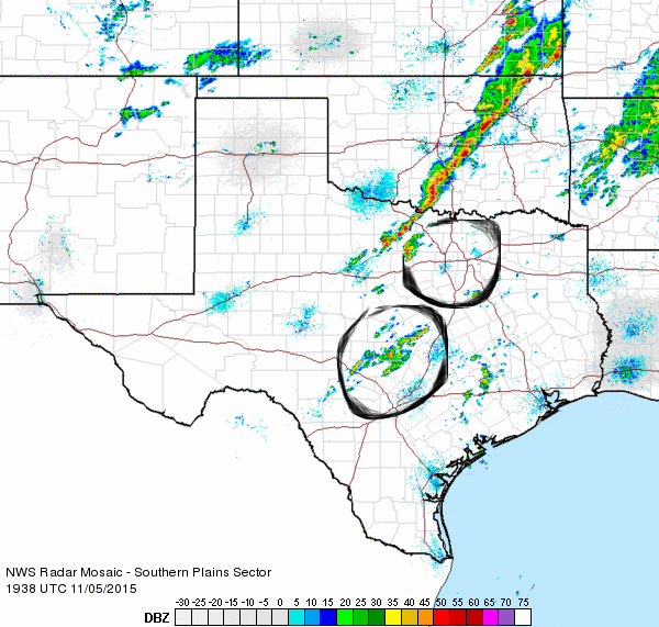
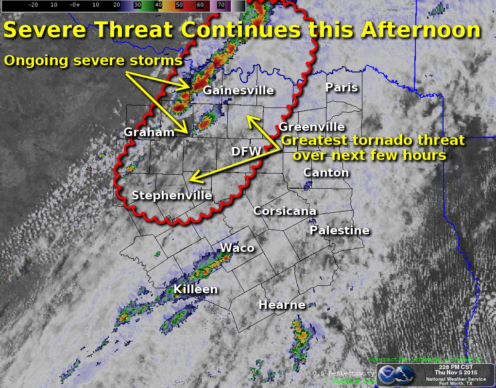
here is the current radar picture:
As can be seen discrete storms are firing along the dry-line moving in a northeastern direction at about 35 mph, now this is just the beginning, as they move further east more storms will fire and they will move into an increasingly unstable and highly moist environment with PWAT(precipitation water) values over 2in which is very high for November so heavy rain is also a threat, and even rain wrapped tornadoes which are among the most deadly. Wind shear is also very high which means there is alot of rotation in the upper atmosphere and likely as these storms move east they will become surface based and super-cellular as several models have indicated.
here is some model data depicting future times:
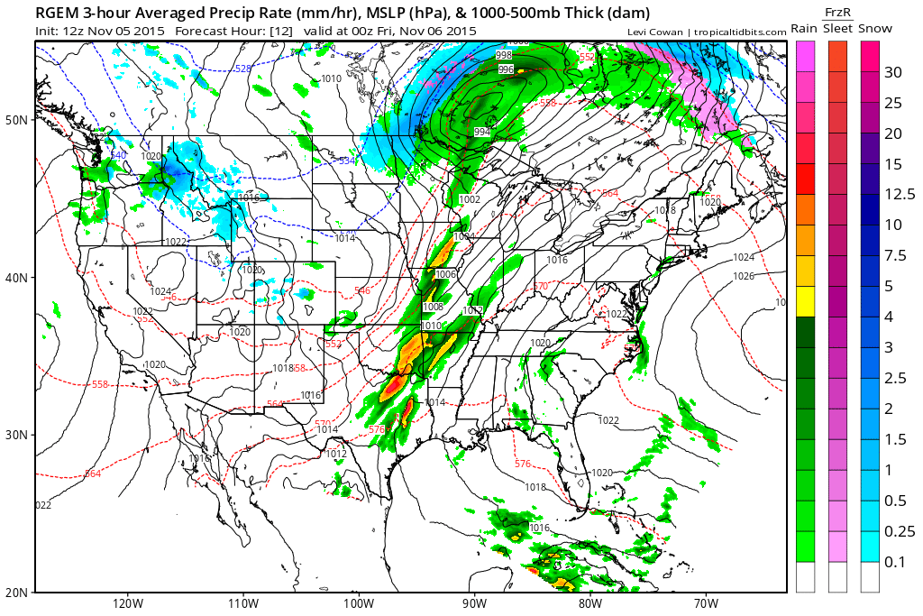
This the RGEM model which is showing 6pm central time as you can see by the brighter colors and red that this is showing heaving rain over Dallas and into Oklahoma
This is the NAM (North American Mesoscale Forecast System) a hi res model which is showing the storm organizing into a squall line around 6pm which would help diminish the tornado threat (but obviously none zero) but increase the damaging wind threat.
Link to hrrr rapid refresh model
this is a loop of another hi res model which updates every hour, and it is showing discrete storms ahead of a developing squall line potentially super-cellular in nature.
From Norman Oklahoma National Weather Service discussion prior to issuing the Tornado watch:
So what does all this mean? well essentially,we have a potential severe weather outbreak effecting the southern planes which could be life threatening, if you live in these areas please keep your eyes on the sky's and keep your ear to the ground,for up to date weather information as to keep you and your family safe, i will update throughout the event.
here is the current radar picture:
As can be seen discrete storms are firing along the dry-line moving in a northeastern direction at about 35 mph, now this is just the beginning, as they move further east more storms will fire and they will move into an increasingly unstable and highly moist environment with PWAT(precipitation water) values over 2in which is very high for November so heavy rain is also a threat, and even rain wrapped tornadoes which are among the most deadly. Wind shear is also very high which means there is alot of rotation in the upper atmosphere and likely as these storms move east they will become surface based and super-cellular as several models have indicated.
here is some model data depicting future times:
This the RGEM model which is showing 6pm central time as you can see by the brighter colors and red that this is showing heaving rain over Dallas and into Oklahoma
This is the NAM (North American Mesoscale Forecast System) a hi res model which is showing the storm organizing into a squall line around 6pm which would help diminish the tornado threat (but obviously none zero) but increase the damaging wind threat.
Link to hrrr rapid refresh model
this is a loop of another hi res model which updates every hour, and it is showing discrete storms ahead of a developing squall line potentially super-cellular in nature.
From Norman Oklahoma National Weather Service discussion prior to issuing the Tornado watch:
MESOSCALE DISCUSSION 1926
NWS STORM PREDICTION CENTER NORMAN OK
1048 AM CST THU NOV 05 2015
AREAS AFFECTED...N CNTRL TX INTO S CNTRL/ERN OK
CONCERNING...SEVERE POTENTIAL...WATCH LIKELY
VALID 051648Z - 051815Z
PROBABILITY OF WATCH ISSUANCE...80 PERCENT
SUMMARY...THE RISK FOR SEVERE STORMS IS EXPECTED TO INCREASE ACROSS
PARTS OF THE SOUTHERN INTO CENTRAL PLAINS...PARTICULARLY ACROSS
PARTS OF NORTH CENTRAL TEXAS INTO SOUTH CENTRAL AND EASTERN
OKLAHOMA...DURING THE 18-21Z TIME FRAME. THIS WILL INCLUDE
POTENTIAL FOR LARGE HAIL...ISOLATED TORNADOES...AND EVENTUALLY AN
INCREASING RISK FOR DAMAGING WIND GUSTS.
DISCUSSION...AN INCREASINGLY DEFORMED BUT STILL SIGNIFICANT SHORT
WAVE IMPULSE IS IN THE PROCESS OF ACCELERATING NORTH NORTHEAST OF
THE SOUTHERN ROCKIES. AS THIS OCCURS...SOUTHWESTERLY 500 MB FLOW IS
FORECAST TO STRENGTHEN IN EXCESS OF 90 KTS WITHIN A NARROW CYCLONIC
BELT ACROSS THE TEXAS/OKLAHOMA PANHANDLE REGION INTO EASTERN KANSAS.
WHILE ASSOCIATED STRONGER MID-LEVEL FORCING FOR UPWARD VERTICAL
MOTION APPEARS LIKELY TO REMAIN LARGELY TO THE NORTHWEST OF THE
REGION...HIGH-LEVEL FLOW IS EXPECTED TO BECOME INCREASINGLY DIFLUENT
AND DIVERGENT ABOVE A MOISTENING LOW-LEVEL ENVIRONMENT ACROSS THE
SOUTHERN PLAINS RED RIVER VALLEY REGION.
MOISTENING...CHARACTERIZED BY SURFACE DEW POINTS INCREASING THROUGH
THE UPPER 60S AND LOWER 70S...IS ONGOING ALONG THE WESTERN PERIPHERY
OF A 30-40 KT SOUTHWESTERLY 850 MB JET STREAK NOSING ACROSS NORTH
CENTRAL TEXAS INTO EASTERN OKLAHOMA. COUPLED WITH INCREASING BREAKS
IN CLOUD COVER...THIS SHOULD LEAD TO SUFFICIENT BOUNDARY LAYER
DESTABILIZATION FOR INCREASING SEVERE STORM POTENTIAL DURING THE
18-21Z TIME FRAME.
VIGOROUS CONVECTIVE DEVELOPMENT IS ALREADY ONGOING TO THE WEST OF
THE REGION...FOCUSED ALONG A PRE-FRONTAL LOW-LEVEL CONFLUENCE
ZONE...BUT CURRENTLY LIKELY STILL ELEVATED. AS THIS ACTIVITY
SPREADS EASTWARD IN THE PRESENCE OF INCREASING INSTABILITY AND
HIGH-LEVEL SUPPORT...SUBSTANTIVE INTENSIFICATION APPEARS PROBABLE
EARLY THIS AFTERNOON. THIS MAY INCLUDE CONTINUING DISCRETE
CONVECTIVE DEVELOPMENT/SUPERCELLS...AND A GRADUALLY EVOLVING
MESOSCALE CONVECTIVE SYSTEM.
So what does all this mean? well essentially,we have a potential severe weather outbreak effecting the southern planes which could be life threatening, if you live in these areas please keep your eyes on the sky's and keep your ear to the ground,for up to date weather information as to keep you and your family safe, i will update throughout the event.
'Tis fall severe weather season across the plains. No one talks about it like they do spring, but it exists and we are in it.
It sure does feel oppressive up in KC where I'm at.
It sure does feel oppressive up in KC where I'm at.
a reply to: TechniXcality
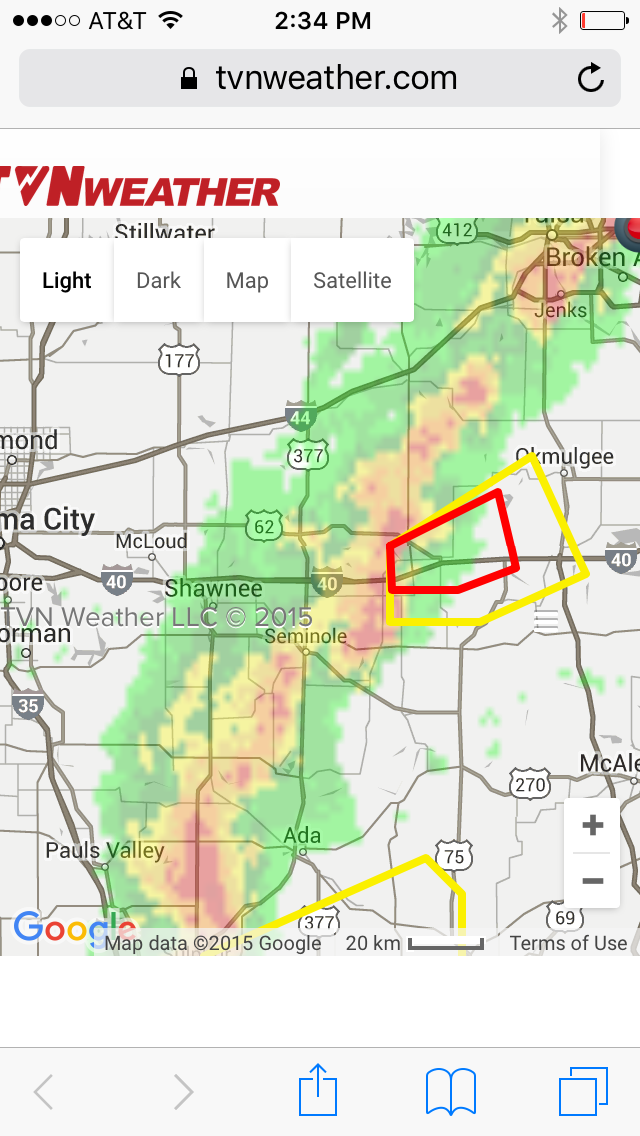
I have a map where I have circled where the two areas of future development appear likely, which is concerning because these areas are ahead of the developing squall line to the west (discrete super cells with the full potential of the atmospheric instability, not inhibited by other storm complexes). These areas we should watch for rapid intensification hence the tornado watch.
This is a severe thunderstorm developing just to the north west of Dallas, in Decatur and the warning statement from the National Weather Service Ft.Worth:
SEVERE THUNDERSTORM WARNING
TXC237-367-497-052100-
/O.NEW.KFWD.SV.W.0344.151105T1955Z-151105T2100Z/
BULLETIN - IMMEDIATE BROADCAST REQUESTED
SEVERE THUNDERSTORM WARNING
NATIONAL WEATHER SERVICE FORT WORTH TX
155 PM CST THU NOV 5 2015
THE NATIONAL WEATHER SERVICE IN FORT WORTH HAS ISSUED A
* SEVERE THUNDERSTORM WARNING FOR...
NORTHERN PARKER COUNTY IN NORTH CENTRAL TEXAS...
WISE COUNTY IN NORTH CENTRAL TEXAS...
SOUTHEASTERN JACK COUNTY IN NORTH CENTRAL TEXAS...
* UNTIL 300 PM CST
* AT 155 PM CST...A SEVERE THUNDERSTORM WAS LOCATED 7 MILES WEST OF
POOLVILLE...OR 14 MILES NORTHEAST OF MINERAL WELLS...MOVING
NORTHEAST AT 50 MPH.
HAZARD...60 MPH WIND GUSTS AND QUARTER SIZE HAIL.
SOURCE...RADAR INDICATED.
IMPACT...HAIL DAMAGE TO VEHICLES IS EXPECTED. EXPECT WIND DAMAGE
TO ROOFS...SIDING AND TREES.
* LOCATIONS IMPACTED INCLUDE...
MINERAL WELLS...DECATUR...BRIDGEPORT...BRIAR...PECAN ACRES...
RENO...SPRINGTOWN...NEW FAIRVIEW...AURORA...BOYD...PARADISE...
POOLVILLE...BOONSVILLE...COTTONDALE...RHOME...RUNAWAY BAY...NEWARK
AND LAKE BRIDGEPORT.
PRECAUTIONARY/PREPAREDNESS ACTIONS...
FOR YOUR PROTECTION MOVE TO AN INTERIOR ROOM ON THE LOWEST FLOOR OF A
BUILDING.
&&
A TORNADO WATCH REMAINS IN EFFECT UNTIL 800 PM CST FOR NORTH CENTRAL
TEXAS.
LAT...LON 3343 9739 3299 9740 3299 9754 3296 9755
3286 9806 3300 9805 3310 9802 3344 9750
TIME...MOT...LOC 1955Z 235DEG 42KT 3302 9798
HAIL...1.00IN
WIND...60MPH
$$
CAVANAUGH
edit on 5-11-2015 by TechniXcality because: (no reason given)
Have had over an inch of rain here where I'm at. A heavy thunderstorm blew through around 12:30. Very ominous looking with low hanging clouds. Some
tiny hail, but nothing damaging. I love a good storm, but I'm ready for some fall weather!
S&F, OP.
I'm posting the TVN (LiveStormChasing) Link,
if anybody would like to follow these storms visually.
^^ I definitely recommend checking it out.
I guess we'll have to wait and see what happens.
All the Best to those in it's path.
I will be following.
I'm posting the TVN (LiveStormChasing) Link,
if anybody would like to follow these storms visually.
^^ I definitely recommend checking it out.
I guess we'll have to wait and see what happens.
All the Best to those in it's path.
I will be following.
edit on 5-11-2015 by iunlimited491 because: (no reason given)
a reply to: iunlimited491
Thank you so much for that, i was looking at the storm-chasers feed near Bowie Texas and it appears that storm has a wall cloud from i could tell,and was definitely surface rooted. If you have anything to add throughout please do, hope everyone stays safe
Thank you so much for that, i was looking at the storm-chasers feed near Bowie Texas and it appears that storm has a wall cloud from i could tell,and was definitely surface rooted. If you have anything to add throughout please do, hope everyone stays safe
I left the DFW area about 3am CST today and traveled east on I-30. Areas east of there, around Sulphur Springs, were getting hit hard with rain. There
was some lightning as well. I'm in West Memphis, Arkansas now. Will be curious to see if it moves this way.
Any members in the line of fire, stay safe!!
Any members in the line of fire, stay safe!!
Okmulgee Oklahoma, east of Oklahoma city, is tornado warned this is life threatening situation, take cover if you are in the area!
Picture of the warned area via radar:
Tornado Warning statment:
Picture of the warned area via radar:
Tornado Warning statment:
SEVERE WEATHER STATEMENT
NATIONAL WEATHER SERVICE TULSA OK
232 PM CST THU NOV 5 2015
OKC107-111-052100-
/O.CON.KTSA.TO.W.0072.000000T0000Z-151105T2100Z/
OKFUSKEE OK-OKMULGEE OK-
232 PM CST THU NOV 5 2015
...A TORNADO WARNING REMAINS IN EFFECT UNTIL 300 PM CST FOR CENTRAL
OKFUSKEE AND SOUTHWESTERN OKMULGEE COUNTIES...
AT 232 PM CST...A SEVERE THUNDERSTORM WITH STRONG LOW LEVEL ROTATION
THAT COULD PRODUCE A TORNADO AT ANY TIME WAS LOCATED OVER OKEMAH...
MOVING NORTHEAST AT 35 MPH.
HAZARD...TORNADO.
SOURCE...RADAR INDICATED ROTATION.
IMPACT...FLYING DEBRIS WILL BE DANGEROUS TO THOSE CAUGHT WITHOUT
SHELTER. MOBILE HOMES WILL BE DAMAGED OR DESTROYED. DAMAGE
TO ROOFS...WINDOWS AND VEHICLES WILL OCCUR. TREE DAMAGE IS
LIKELY.
LOCATIONS IN OR NEAR THE PATH INCLUDE...
OKEMAH... BEARDEN...
CASTLE... CLEARVIEW...
PHAROAH...
THIS INCLUDES INTERSTATE 40 IN OKLAHOMA BETWEEN MILE MARKERS 212 AND
231.
PRECAUTIONARY/PREPAREDNESS ACTIONS...
TAKE COVER NOW! MOVE TO A BASEMENT OR AN INTERIOR ROOM ON THE LOWEST
FLOOR OF A STURDY BUILDING. AVOID WINDOWS. IF YOU ARE OUTDOORS...IN A
MOBILE HOME...OR IN A VEHICLE...MOVE TO THE CLOSEST SUBSTANTIAL
SHELTER AND PROTECT YOURSELF FROM FLYING DEBRIS.
&&
a reply to: IamAbeliever
yes but that area should be at threat later tonight 6pm - 12am: with a squall-line so damaging straight line winds likely, drive safe be careful.
yes but that area should be at threat later tonight 6pm - 12am: with a squall-line so damaging straight line winds likely, drive safe be careful.
a reply to: IridiumFlareMadness
I don't know if you are in the area but per National Weather Service, please stay safe.
I don't know if you are in the area but per National Weather Service, please stay safe.
a reply to: TechniXcality
I'm just SE of Ft. Worth and I put the dogs inside (they have a dog run with dog houses so are ok with some rain) but I don't get off work until 530pm and want them in the house in case of any severe weather.
I am also a major weather and aviation nerd (ask my wife when we fly or there is any significant weather event LOL) some folks don't get as fascinated by it, but I think everyone appreciates the raw power of nature.
Good luck to everyone this evening! I'll post with anything going on near me as this all develops.
FYI - speaking of aviation, if anyone is bothered by turbulence don't fly into DFW in the spring or early fall, LOL...
Thank you for posting. I am in the top circle. Last I heard it was a slight risk with greater risk to the east. However sun has been out off and on
and temp is 80.
Stay safe y'all.
Stay safe y'all.
a reply to: TechniXcality
I live right in the middle of the top circle you drew and I work in Decatur. We had a pretty heavy storm hit about 30 mins ago but luckily no hail and it only lasted about 10 mins. But from what I hear and from what you are saying, the worst is on its' way. I'll keep yall posted.
I live right in the middle of the top circle you drew and I work in Decatur. We had a pretty heavy storm hit about 30 mins ago but luckily no hail and it only lasted about 10 mins. But from what I hear and from what you are saying, the worst is on its' way. I'll keep yall posted.
edit on
5-11-2015 by Rexamus because: (no reason given)
a reply to: liveandlearn
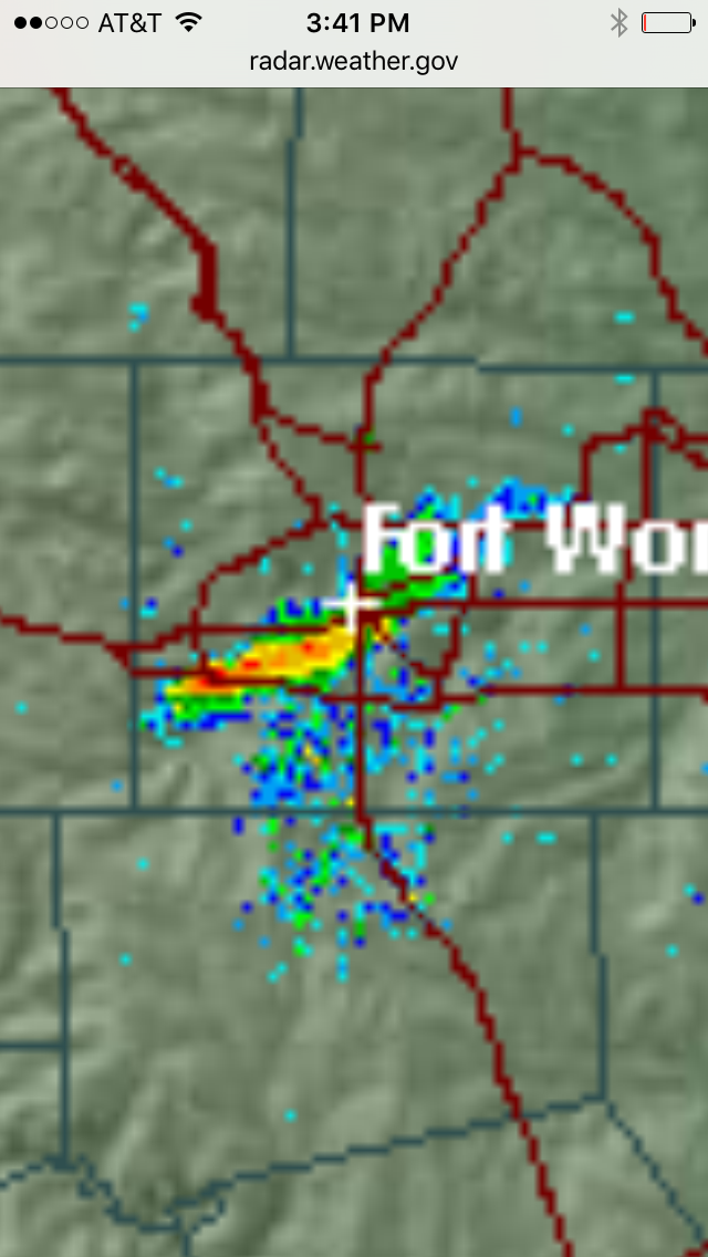
Looks like near Benbrook southwest Ft. Worth we have a developing cell, that could potentially go severe..
Note: clouds are breaking CAPE values are rising the atmosphere is becoming increasingly unstable.
Here is a picture of the particular storm, i would not be surprised if it is severe warned anytime, as it is intensifying on radar. Those in the path would include downtown Ft.Worth and South eastern Denton county.
Stay safe will update:
edit on 5-11-2015 by TechniXcality because: (no reason given)
a reply to: Rexamus
Ft.Worth National weather service afternoon discussion :
Ft.Worth National weather service afternoon discussion :
A LINE OF STRONG TO SEVERE CONVECTION HAS MOVED INTO THE NORTHWEST
COUNTIES THIS AFTERNOON AND WILL PROGRESS THROUGH MUCH OF THE CWA
THIS EVENING. FORCING FOR ASCENT WILL CONTINUE TO INCREASE
THROUGH THIS EVENING AS A STRONG SHORT WAVE MOVES ACROSS THE GREAT
PLAINS. AHEAD OF THE SHORT WAVE IS A 100+ KNOT JET THAT EXTENDS
DOWN INTO NORTH TEXAS WITH THE REAR ENTRANCE REGION ALOFT AIDING
FORCING FROM ABOVE. A DRYLINE OVER WEST TEXAS IS AIDING LOW LEVEL
CONVERGENCE AND HELPING TO PUSH THIS CONVECTIVE LINE ACROSS THE
REGION. THE ATMOSPHERE AHEAD OF THIS ACTIVITY IS UNSTABLE AND HAS
ENOUGH SFC-1KM HELICITY TO PRODUCE STRONG ROTATING UPDRAFTS. THUS SOME
TORNADOES...LARGE HAIL AND DAMAGING WINDS ARE POSSIBLE THROUGH
MID EVENING AT LEAST. THE ACTIVITY COMING OUT OF THE TEXAS HILL
COUNTRY IS OF CONCERN AS IT CONTINUES TO INCREASE IN COVERAGE
THIS AFTERNOON AND INTO THE EVENING. LATER THIS EVENING...THIS
SYSTEM AND THE UPSTREAM LINEAR CONVECTION WILL LIKELY CONGEAL INTO
ONE EXTENSIVE BAND OF RAIN/STORMS. THIS WILL RESULT IN HEAVY RAIN
CORES AND ECHO TRAINING THAT WILL PRODUCE RAIN SWATCHES OF 1 TO 2
INCHES WITH SOME HIGHER AMOUNTS...THUS THE FLASH FLOOD WATCH WILL
REMAIN AS IS THROUGH MIDNIGHT.
a reply to: TechniXcality
Yes, I was keeping an eye on that. Live just south of Ft Worth and little east of 35w.
Btw, love the link you and iunlimited491 gave. WFAA is my go to for weather but was unaware of this tool.
Know how I will be spending the evening.
Yes, I was keeping an eye on that. Live just south of Ft Worth and little east of 35w.
Btw, love the link you and iunlimited491 gave. WFAA is my go to for weather but was unaware of this tool.
Know how I will be spending the evening.
edit on 5-11-2015 by liveandlearn because: (no reason given)
a reply to: liveandlearn
From this particular storm you look like you are in the clear momentarily but remember these storms will continue to fire and eventually form into a squall line effecting all of north Texas, thank you for your kind words
From this particular storm you look like you are in the clear momentarily but remember these storms will continue to fire and eventually form into a squall line effecting all of north Texas, thank you for your kind words
new topics
-
For Votes - President BIDEN Opens ObamaCare Health Ins to Illegal Aliens Eff Nov 1st 2024.
2024 Elections: 1 hours ago -
EPA sues San Francisco for dumping billions of gallons of sewage into Pacific Ocean
US Political Madness: 1 hours ago -
Prophets versus priests; - Getting God's help
Religion, Faith, And Theology: 3 hours ago -
UN Estimates Rebuilding Gaza Will Cost Up To 40 Billion Dollars
Middle East Issues: 5 hours ago -
Study Finds The More Covid Vaccine Doses You Have, the More Likely You Are to Get Covid
Medical Issues & Conspiracies: 6 hours ago -
Wounded Orangutan seen using a Plant as Medicine for the First Time
Fragile Earth: 6 hours ago -
Democratic Rep. Henry Cuellar and wife indicted on federal bribery charges
US Political Madness: 7 hours ago -
An AI-controlled fighter jet took the Air Force leader for a historic ride
Military Projects: 7 hours ago -
SEC shuts down Trump Media auditor, BF Borgers, over fraud
Mainstream News: 7 hours ago -
Farmers jailed without due process
General Conspiracies: 8 hours ago
top topics
-
Wounded Orangutan seen using a Plant as Medicine for the First Time
Fragile Earth: 6 hours ago, 13 flags -
Study Finds The More Covid Vaccine Doses You Have, the More Likely You Are to Get Covid
Medical Issues & Conspiracies: 6 hours ago, 13 flags -
Farmers jailed without due process
General Conspiracies: 8 hours ago, 8 flags -
UN Estimates Rebuilding Gaza Will Cost Up To 40 Billion Dollars
Middle East Issues: 5 hours ago, 6 flags -
Democratic Rep. Henry Cuellar and wife indicted on federal bribery charges
US Political Madness: 7 hours ago, 6 flags -
EPA sues San Francisco for dumping billions of gallons of sewage into Pacific Ocean
US Political Madness: 1 hours ago, 5 flags -
Poll - Catholic Support Swings to Trump By Significant Margin
2024 Elections: 11 hours ago, 5 flags -
SEC shuts down Trump Media auditor, BF Borgers, over fraud
Mainstream News: 7 hours ago, 5 flags -
For Votes - President BIDEN Opens ObamaCare Health Ins to Illegal Aliens Eff Nov 1st 2024.
2024 Elections: 1 hours ago, 4 flags -
An AI-controlled fighter jet took the Air Force leader for a historic ride
Military Projects: 7 hours ago, 2 flags
active topics
-
EPA sues San Francisco for dumping billions of gallons of sewage into Pacific Ocean
US Political Madness • 12 • : xuenchen -
Candidate TRUMP Now Has Crazy Judge JUAN MERCHAN After Him - The Stormy Daniels Hush-Money Case.
Political Conspiracies • 1130 • : Annee -
Doctors Predict Epidemic of Prion Brain Diseases From mRna Jab
Health & Wellness • 63 • : nugget1 -
Study Finds The More Covid Vaccine Doses You Have, the More Likely You Are to Get Covid
Medical Issues & Conspiracies • 18 • : Zanti Misfit -
Democratic Rep. Henry Cuellar and wife indicted on federal bribery charges
US Political Madness • 17 • : Zanti Misfit -
Poll - Catholic Support Swings to Trump By Significant Margin
2024 Elections • 25 • : Zanti Misfit -
What is "Genocide"?
US Political Madness • 51 • : cherokeetroy -
For Votes - President BIDEN Opens ObamaCare Health Ins to Illegal Aliens Eff Nov 1st 2024.
2024 Elections • 5 • : JAY1980 -
James O’Keefe: I have evidence that exposes the CIA, and it’s on camera.
Whistle Blowers and Leaked Documents • 64 • : pianopraze -
Some hard numbers about the Vax and the effort to cover up said numbers
General Conspiracies • 87 • : Zanti Misfit