It looks like you're using an Ad Blocker.
Please white-list or disable AboveTopSecret.com in your ad-blocking tool.
Thank you.
Some features of ATS will be disabled while you continue to use an ad-blocker.
7
share:
I wasnt sure if this has been brought up or if this is the right forums for this, but being that it kind of leaks into every facet of this site
potentially I thought that the gray area would be a good start.
I often peruse Google Earth for fun, its awesome the level of detail it shows and how you can almost travel anywhere in the workd right form your seat...
However since it original inception waaay back when I was in high school, there has always been 1 anomaly in google earth that has stood out to me, and blatantly so. This has ALWAYS been here even though the images are updated annually at a minimum so I dont believe its simply could cover" darkening the water.. or "image splicing" or sections of the photo taken at different times/settings because this has always been here and hasnt changed.


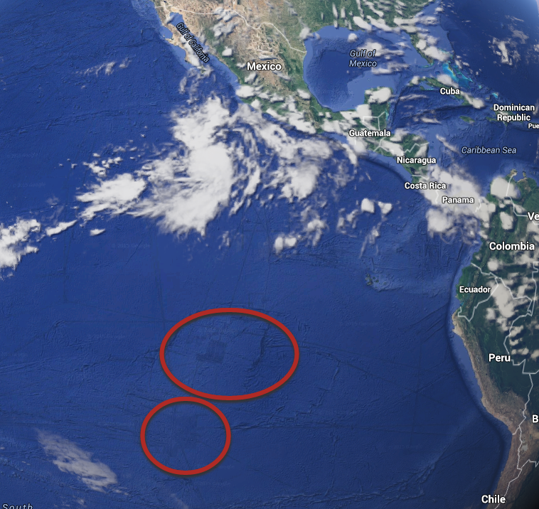
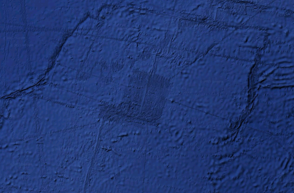
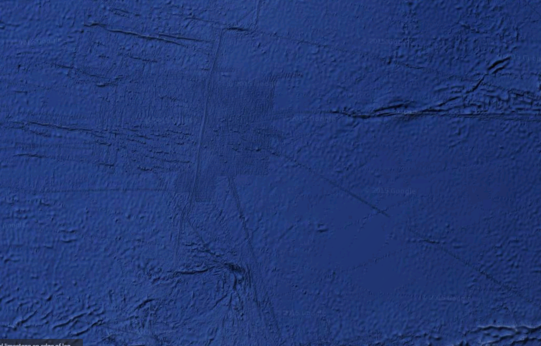
These 2 locations (dark spots out in the middle of NOWHERE out in the south eastern Pacific ocean) have perfect right angles and dont look natural.
I guess my theory is that these are "shadows" to an extend of something LARGE under the water. What is even more intriguing are the perfectly straight lines that expand outward from these locations that extend all over the globe.
I guess a simple explanation could be that these are underwater plateaus, and the lines are simply cracks and fault lines in the tectonic plates.A completely reasonable explanation.
Or as I said earlier, it could just be a satellite camera goof.
But of course when I see things like this, my imagination runs wild as to the possibilities...
Could it be an underwater base of some sort?
Government facility with underwater transit lines all over the globe?
An Extraterrestrial facility?
Could it be ancient ruins underwater? Maybe "Atlantis" wasnt in the Atlantic after all..
I just thought it would be a fun thing to post up and to see if anyone has any answers/theories etc.
I often peruse Google Earth for fun, its awesome the level of detail it shows and how you can almost travel anywhere in the workd right form your seat...
However since it original inception waaay back when I was in high school, there has always been 1 anomaly in google earth that has stood out to me, and blatantly so. This has ALWAYS been here even though the images are updated annually at a minimum so I dont believe its simply could cover" darkening the water.. or "image splicing" or sections of the photo taken at different times/settings because this has always been here and hasnt changed.


These 2 locations (dark spots out in the middle of NOWHERE out in the south eastern Pacific ocean) have perfect right angles and dont look natural.
I guess my theory is that these are "shadows" to an extend of something LARGE under the water. What is even more intriguing are the perfectly straight lines that expand outward from these locations that extend all over the globe.
I guess a simple explanation could be that these are underwater plateaus, and the lines are simply cracks and fault lines in the tectonic plates.A completely reasonable explanation.
Or as I said earlier, it could just be a satellite camera goof.
But of course when I see things like this, my imagination runs wild as to the possibilities...
Could it be an underwater base of some sort?
Government facility with underwater transit lines all over the globe?
An Extraterrestrial facility?
Could it be ancient ruins underwater? Maybe "Atlantis" wasnt in the Atlantic after all..
I just thought it would be a fun thing to post up and to see if anyone has any answers/theories etc.
i mean i wouldnt put any faith in google earth cause im pretty sure google puts things in there as like Easter eggs for people to find lol.
The resolution of the bathymetry data available on Google Earth varies in resolution and coverage.
The "anomalies" you are seeing is a result.
The "anomalies" you are seeing is a result.
There are loads of strange things on the sea floor, here is an old thread of mine on the
subject.
-MM
-MM
edit on 6-9-2015 by MerkabaMeditation because: (no reason given)
When we know how United-States love to make secret military bases, it's not hard to think that it could be a military complex underwater. Maybe a big
submarine base, it can be a lot of thing and yes, no theories are wrong until proven as such! Keep using your imagination, the universe is far more
stranger than what they show to us!
Thanks for the replies everyone!
The key reason I don't believe it is image splicing or a change in the cameras resolution or detail.. is because no where else on Google Earth does this phenomena occur (with perfect defined shapes like that) except for a small spot under australia.. I've checked almost everywhere.
Something else is crazy about it as well.. look at the shape of the bottom site. The right angles are combined with deliberate curves in some areas giving what would be some sort of "bay window" effect.
About the lines (trenches) that protrude from these sites... if you follow them you end up in some interesting places.
-Easter island (now that's odd)
-Valparaiso, Chile (a major international port)
-Isla Guadalupe, Mexico
-San Diego, US
-Anaa, French Polynesia
-ocona, Peru (not far away from Nazca and the location deep inland with the walls)
-Hawaii, US
I wonder if there is anything that makes these places unique or that makes them "connected"
a reply to: Lucidparadox
Judging the scale from the first picture, these things are the size of a state. We can probably rule out underwater bases.
Judging the scale from the first picture, these things are the size of a state. We can probably rule out underwater bases.
a reply to: Lucidparadox
You can't see the difference in resolution when you zoom in? You can't see that your "anomalous" areas are higher resolution that the surrounding areas?
Have you looked between Australia and Antarctica? Southeast of New Zealand?
The key reason I don't believe it is image splicing or a change in the cameras resolution or detail.. is because no where else on Google Earth does this phenomena occur
You can't see the difference in resolution when you zoom in? You can't see that your "anomalous" areas are higher resolution that the surrounding areas?
Have you looked between Australia and Antarctica? Southeast of New Zealand?
edit on 9/6/2015 by Phage because: (no reason given)
a reply to: Phage
I do believe I mentioned the location south of austrailia
I said outside of that there isnt any other location..
Also.. wouldnt these spots have been changed over the last 10 years? Seeing as how google updates their images if that were the case?
Im not saying you are wrong, Im just keeping the options open here
a reply to: Lucidparadox
www.ldeo.columbia.edu...
You missed southeast of New Zealand.
I said outside of that there isnt any other location..
If there is new data available Google gets around to updating. Sometimes. Eventually. You don't think it's anything like realtime do you? What makes you think there's new data for the surrounding, low resolution, areas? They do provide the source of the data, after all.
Also.. wouldnt these spots have been changed over the last 10 years? Seeing as how google updates their images if that were the case?
www.ldeo.columbia.edu...
edit on 9/6/2015 by Phage because: (no reason given)
a reply to: Lucidparadox
At least the Brazil and Easter Island have surely some pieces of human history that they want to hide, that would explain why it is also connected to the USA, or/and they can send their founds to the Vatican, with the international airport.
At least the Brazil and Easter Island have surely some pieces of human history that they want to hide, that would explain why it is also connected to the USA, or/and they can send their founds to the Vatican, with the international airport.
new topics
-
Elon's Starlink Stole The Election For Trump--Leftist Conspiracy Theorists Charge
General Conspiracies: 2 hours ago -
Speaker Johnson Orders Entire Biden Administration to Preserve and Retain All Records - Documents
US Political Madness: 2 hours ago -
Resident Plane enthusiasts needed weird noise
General Chit Chat: 5 hours ago -
Fired FEMA Employee Says It Was Not ‘Isolated’ Incident: ‘Colossal Event Of Avoidance’
US Political Madness: 8 hours ago -
Australia has been holding out on us
Music: 8 hours ago
top topics
-
Fired FEMA Employee Says It Was Not ‘Isolated’ Incident: ‘Colossal Event Of Avoidance’
US Political Madness: 8 hours ago, 22 flags -
Speaker Johnson Orders Entire Biden Administration to Preserve and Retain All Records - Documents
US Political Madness: 2 hours ago, 14 flags -
Elon's Starlink Stole The Election For Trump--Leftist Conspiracy Theorists Charge
General Conspiracies: 2 hours ago, 13 flags -
Resident Plane enthusiasts needed weird noise
General Chit Chat: 5 hours ago, 4 flags -
Australia has been holding out on us
Music: 8 hours ago, 3 flags
active topics
-
President-Elect DONALD TRUMP's 2nd-Term Administration Takes Shape.
Political Ideology • 126 • : RazorV66 -
Speaker Johnson Orders Entire Biden Administration to Preserve and Retain All Records - Documents
US Political Madness • 18 • : WeMustCare -
Trump Portrait Ended Better Than Expected--WATCH THIS
2024 Elections • 13 • : CarlLaFong -
Elon's Starlink Stole The Election For Trump--Leftist Conspiracy Theorists Charge
General Conspiracies • 13 • : CriticalStinker -
Resident Plane enthusiasts needed weird noise
General Chit Chat • 9 • : Flyingclaydisk -
JOE Biden's secret polling shows Trump destroying the president
2024 Elections • 18 • : WannabeeAuCourant -
Should we look for the truth, or just let it go?
US Political Madness • 90 • : argentus -
-@TH3WH17ERABB17- -Q- ---TIME TO SHOW THE WORLD--- -Part- --44--
Dissecting Disinformation • 3244 • : fringeofthefringe -
Fired FEMA Employee Says It Was Not ‘Isolated’ Incident: ‘Colossal Event Of Avoidance’
US Political Madness • 33 • : Flyingclaydisk -
President-Elect Donald Trump will Meet with Coup-Victim JOE BIDEN on Wed 11.13.2024.
2024 Elections • 15 • : marg6043
7
