It looks like you're using an Ad Blocker.
Please white-list or disable AboveTopSecret.com in your ad-blocking tool.
Thank you.
Some features of ATS will be disabled while you continue to use an ad-blocker.

The Saginaw Bay Impact
page: 121
share:
There has been a lot of talk about the Carolina Bays and what caused them, recently two reaserchers, Micheal Davias and Thomas Harris, have proposed a
new scenario on how the bays were formed, and how they are connected to the Australasian Tektite strewnfield.
Carolina bays;
Carolina Bays
title
"CarolinaBays-USGS" by . The original uploader was Seth Ilys at English Wikipedia - U.S. government photo, from www.csc.noaa.gov... Licensed under Public Domain via Wikimedia Commons - commons.wikimedia.org...:CarolinaBays-USGS.JPG#/media/File:CarolinaBays-USGS.JPG
The Australasian Tektite strewnfield,
Australasian Strewn Field
"Australasian strewnfield" by syncmedia - Own work. Licensed under CC0 via Wikimedia Commons - commons.wikimedia.org...:Australasian_strewnfield.jpg#/media/File:Australasian_strewnfield.jpg
Carolina bays;
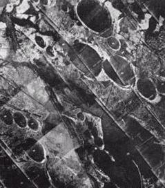
Carolina bays are elliptical depressions concentrated along the Atlantic seaboard within coastal Delaware, Maryland, New Jersey, North Carolina, South Carolina, Virginia, Georgia, and northcentral Florida (Prouty 1952, Kaczorowski 1977). In Maryland, they are called Maryland Basins (Rasmussen and Slaughter 1955). Within the Delmarva Peninsula, they and other coastal ponds are also called Delmarva bays (Coleman nd).
Other landform depressions, not widely accepted as Carolina bays, are found within the northern Gulf of Mexico coastal plain in southeast Mississippi and Alabama, where they are known as either Grady ponds or Citronelle ponds (Otvos 1976, Folkerts 1997). Carolina bays vary in size from one to several thousand acres. About 500,000 of them are present in the classic area of the Atlantic Coastal Plain, often in groups, with each bay invariably aligned in a northwest-southeast direction. The bays have many different vegetative structures, based on the depression depth, size, hydrology, and subsurface. Many are marshy; a few of the larger ones are (or were before drainage) lakes; 36 square km (14 square mile) Lake Waccamaw is an undrained one. Some bays are predominantly open water with large scattered pond cypress, while others are composed of thick, shrubby areas (pocosins), with vegetation growing on floating peat mats. Generally the southeastern end has a higher rim composed of white sand. They are named for the bay trees frequently found in them, not because of the frequent ponding of water (Sharitz 2003).
Undrained, often circular to oval, depressions exhibiting a wide range of area and depth are also a very common feature of the Gulf of Mexico coastal plain within Texas and southwest Louisiana. These depressions vary in size from 0.4 to 3.6 km (0.25 to 2 miles) in diameter. Within Harris County, Texas, raised rims, which are about 0.65 m (2 ft) high, partially enclosed these depressions. In the scientific literature, they are known by a variety of names, including “pocks”, “pock marks”, “bagols”, “lacs ronds”, and “natural ponds” (Aronow nda, ndb).
Carolina Bays
title
"CarolinaBays-USGS" by . The original uploader was Seth Ilys at English Wikipedia - U.S. government photo, from www.csc.noaa.gov... Licensed under Public Domain via Wikimedia Commons - commons.wikimedia.org...:CarolinaBays-USGS.JPG#/media/File:CarolinaBays-USGS.JPG
The Australasian Tektite strewnfield,
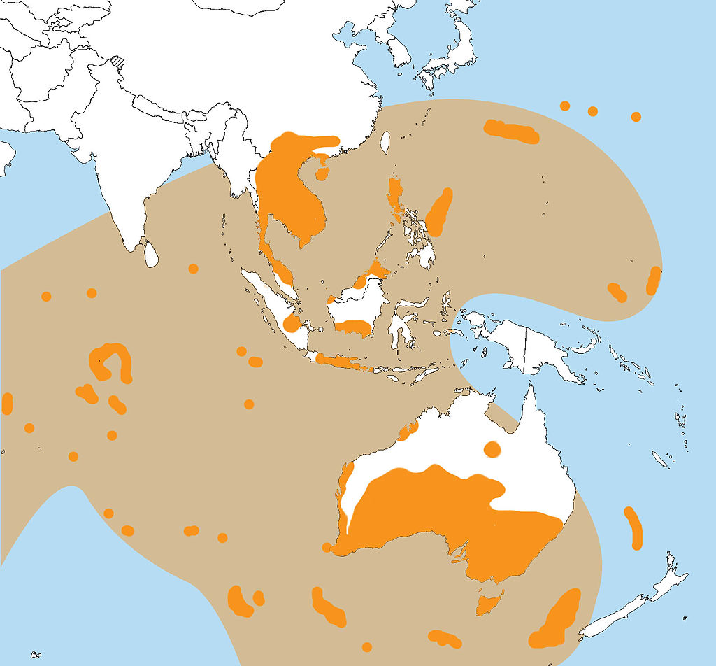
The Australasian strewnfield, covering at least one-tenth of the Earth's surface, is the largest and the youngest of the tektite strewnfields. The 800,000 year-old strewnfield includes most of Southeast Asia (Vietnam, Thailand, Southern China, Laos and Cambodia). The material from the impact stretches across the ocean to include the islands of the Philippines, Indonesia, Malaysia and Java and reaches far out into the Indian Ocean and south to the western side of Australia.
Australasian strewnfield.
The impact crater may have been between 32 and 114 kilometres in diameter (compare to the 180-km Chicxulub crater). Also, some recent estimates suggest that the strewn field may cover 30% of the Earth's surface (Povenmire et al.).
Archeological artifacts found with these tektites suggests that a Homo Erectus population was living in the area during and after the impact.[1][2][3] Stone tools have been found within the debris field along with a charcoal layer likely caused by fires from the impact. This impact area allowed this population easier access to stones useful for tool making, after the subsequent local deforestation. At Trinil, Java, blackened bone and charcoal deposits have been found among H. erectus fossils, dated from 500,000 to 830,000 BP indicating use of fire.
Australasian Strewn Field
"Australasian strewnfield" by syncmedia - Own work. Licensed under CC0 via Wikimedia Commons - commons.wikimedia.org...:Australasian_strewnfield.jpg#/media/File:Australasian_strewnfield.jpg
Continued:
Now for the Saginaw bay connection, a couple of months ago the authors gave a presentation to the Geological Society of America on the subject.
Cosmic Tusk
Now for the Saginaw bay connection, a couple of months ago the authors gave a presentation to the Geological Society of America on the subject.
A TALE OF TWO CRATERS: CORIOLIS-AWARE TRAJECTORY ANALYSIS CORRELATES TWO PLEISTOCENE IMPACT STREWN FIELDS AND GIVES MICHIGAN A THUMB
Michael Davias, Stamford, CT and Thomas Harris, Lockheed-Martin (Retired), Orbit Operations, Valley Forge, PA
Pleistocene Epoch cosmic impacts have been implicated in the geomorphology of two enigmatic events. Remarkably, in both cases spirited debates remain unsettled after nearly 100 years of extensive research. Consensus opinion holds that the Australasian (AA) tektites are of terrestrial origin despite the failure to locate the putative crater, while a cosmic link to the Carolina bays is considered soundly falsified by the very same lack of a crater.
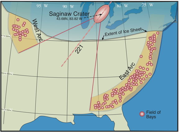
Likely >100 km in diameter, these impacts during geologically recent times should be readily detectable on the Earth’s surface. The improbability that two craters have eluded detection informs a hypothesis that a single impact at ~786 ka generated AA tektites as distal ejecta and Carolina bays as progeny of proximal ejecta. The AA astroblem search is focused on SE Asia despite a strewn field encompassing >30% of the Earth’s surface. This spatial scope implies to us that interhemispheric transits should be considered, as does findings that AA tektites were solidified in a vacuum, then ablated on re-entry at ~10 km sec-1. A Coriolis-aware triangulation network operating on the orientations of 44,000 Carolina bays indicates a focus near 43ºN, 84ºW. Referencing the work of Urey and Lin, we propose that a near-tangential strike to the Earth’s limb generated the 150 x 300 km oval depression that excises Saginaw Bay and opens Michigan’s Thumb. That region was likely buried under deep MIS 19 Laurentide ice at 786 ka. Schultz has shown that oblique impacts into continental ice sheets yield non-traditional astroblems, and multiple glaciations have since reworked this site, making identification more challenging. Hypervelocity gun tests show that oblique impacts produce a vertical plume of ejecta, biased slightly down-range. Ballistic trajectories reflecting such a plume deliver tektites to all AA finds when lofted at ~10 km sec-1 and parameterized with the proposed depression’s location and 222º azimuth. Chemical and isotopic characteristics of AA tektites suggest they were sourced from sandstone and greywacke of Mesozoic age, which is congruent with Michigan Basin strata lost when The Thumb developed. The distribution of proximal ejecta may explain anomalous pulses of regolith in moraines and sediment loading in regional drainage basins recently dated ~800 ka using 10Be/26Al methods.
Cosmic Tusk
From the source,
Saginaw Impact Structure
Much of the issue with identifing the soruce for the austrasian tektites has been the lack of a suitable crater.
Saginaw Bay fills that bill quite nicely,
A low angle impact crater on mars
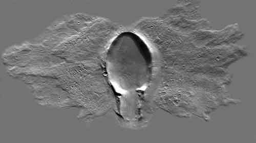
Oblique Impact Crater on Mars with ejecta butterfly
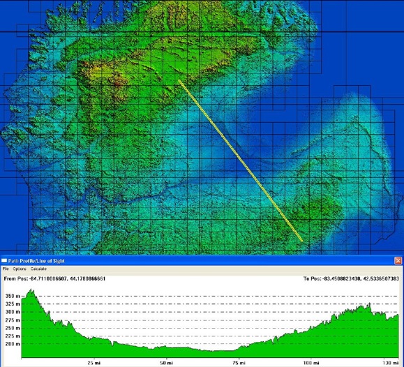
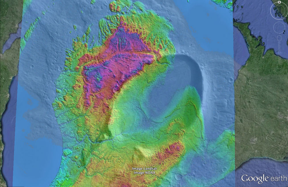
Oval Crater as Google Earth Overlay on Saginaw Region
Saginaw Impact Structure
Our analysis correlates numerous proposed ejecta structures - including the Carolina bays and the Goldsboro Ridge - to a cometary impact event that struck the Mid Pleistocene MIS 20 ice shield approximately 786,000 years ago.
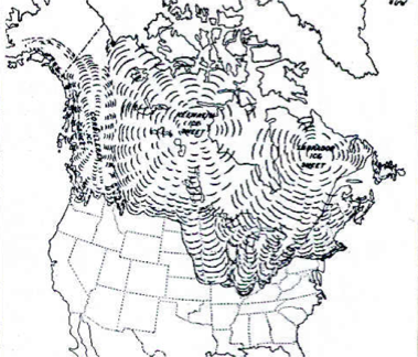
The graphics below presents a view of the glacial coverage of NA at the furthest advance of the Illinoian age, and it is likely the ice sheet at the peak of MIS 20 would have been more extensive.
North American Ice Sheet
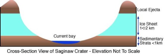
We have theorized that a shallow angle-of-incidence impact occurred into a 1k to 2km thick ice sheet, which dissipated much of the impact energy. The oblique impact is seen as carving out shallow, oval impact craters, as discussed in the Unique Impacts chapter.
Pulverized ice effectively mobilized and hydrated the ejecta, which would have been composed of sedimentary strata from the terrestrial crater, elements of the impactor and significant quantities of ice from the glacial cover. Invoking an Illinoisan Ice Sheet also provides a vehicle to minimize local ejecta, as it would have landed on the sheet and eventually be carried south and deposited across Michigan, Indiana and Ohio. As a direct result of the impact, sheets of distal ejecta are seen as being propelled at high velocities to fall as a "rain" of debris across the continent. A primary focus of our review of that debris is the enigmatic Carolina bay landforms. These landforms, discussed in the Distal Ejecta chapter, present an ovoid shape that suggest an inferred alignment. While these are often accepted as being wind-driven sand dune and lacustrine landforms, aligned with the prevailing winds, we see them as "paint splatters" spread as a coating by the distal ejecta sheet. Attempts tracing "back along" the inferred alignment has presented a fuzzy focus, where the southern-most bays' alignments seems to rotate further to the North.
Carolina bay Orientation - Eyton & Parkhurst
The general "rotation" of inbound ejecta trajectory represented in the Eyton & Parkhurst graphic (discussed in the Carolina bays section) is the manifestation of two different factors. The first being the the Earth's rotation during the loft period (systematic by loft time). As a result, their azimuth will "seem" to be directed back towards a point further west than the actual ejection point. This effect will reverse if the emplacement site is further towards the pole than the ejection site. In the second effect, ejecta droplets will be skewed along the w>e axis due to the change in west-to-east ground rotation vector between the latitudes of the ejection site and the landing site, which we refer to as "systematic by latitude". A more detailed discussion of this aspect of the Carolina bays is discussed in the Inferred Alignment chapter.
Carolina bay Orientation - Eyton & Parkhurst
The Carolina Bays display a marked alignment with northwest-southeast being the preferred orientation. Although there are minor local fluctuations, deviations from the preferred orientation appear to be systematic by latitude (Prouty, 1952).(1)
Much of the issue with identifing the soruce for the austrasian tektites has been the lack of a suitable crater.
Saginaw Bay fills that bill quite nicely,
Researchers have examined the "moraines" of the Saginaw Glacial Lobe and have offered several solutions to their anomalous relationship with the other Wisconsin-Era Ice Sheet lobes. Both the Michigan and the Huron/Erie lobes are seen as having overridden the original terminal margins of the Saginaw lobe, presenting a confusing picture of its advance and retreat. We ask the question: did the "Saginaw Lobe" ever exist?, or could the excision of the central Michigan landscape be the result of a cosmic impact? While there is good reason to expect that the central Michigan Peninsula was covered by a deep ice sheet, as it traversed down from the north, we question the existence of the "plunge" and focused Saginaw lobe advance from the northeast as commonly portrayed.
Our current proposal holds that the impact carved out much of the current bedrock topography of the Michigan basin surrounding and west of the Saginaw Bay. Local ejecta, distributed in a butterfly pattern, was heaped on top of the then-present ice sheet. As the sheet melted beneath the ejecta blanket, many of the enigmatic "moraines", hummocks and tunnel landforms were created. Eventually, the large lake created within the ice sheet crater catastrophically drained southward, similar to that assumed to have occurred during the post-LGM Kankakee Torrent, and later the Central Kalamazoo River Valley (CKRV).
A low angle impact crater on mars
Oblique Impact Crater on Mars with ejecta butterfly
We theorize that the impact occurred into a 1k to 2km thick ice sheet, which adsorbed much of the impact energy. Pulverized ice effectively mobilized and hydrated the ejecta, composed of sedimentary strata from the terrestrial crater, ice from the overlying sheet, and elements of the impactor. Much of that volume would be deposited locally, but we note that invoking an Illinoian Ice Sheet at MIS 20 also provides a vehicle to minimize local ejecta, as it would have landed on the sheet and eventually deposited randomly as glacial till over the following 7 glacial eras.
Oval Crater as Google Earth Overlay on Saginaw Region
a reply to: punkinworks10
Last year as I was flying to Washington DC, you could clearly see the western arc of "bays" across the landscape of the plains up into the rockies.
I cant seem to find the analysis of the tektite compositions,
but it shows that the tektites from the australasian strewnfield are from the rocks of the Michigan pennisula.
For more info on the actual presentation Davias & Harris PDF
This era was pivotal to early man as there were movments of people into new areas and new behaviours came about, there was also the eruption of the long valley caldera and a magnetic field polarity shift.
Ejecta Volume Calculations
Using the cut/fill facility in Global Mapper, we calculated that the crater excavated approximately 2,300 cubic kilometers of sedimentary strata from the crater. Given a conservative average ice cover of 500 meters, the 32,000 square kilometers of crater surface area would supply another 16,000 cubic kilometers of pulverized ice to the slurry mix. A 30 km impactor would supply ~14,000 cubic kilometers of hydrated silica. These values would yield a sand/water ratio of 1:1. A substantial majority of the 16,000 cubic kilometers of ejecta would likely fall locally back onto the ice sheet, to be distributed as "glacial till" as the sheet retreats. Using a conservative estimate of 10% as distal, the 1,600 cubic km of debris would be capable of blanketing 300,000 square kilometers of North America with a 5-meter thick distal ejecta sheet.
Radial Ejecta Loft Distances
The distribution of Carolina bay formations is geographically distributed radially around the chosen Saginaw centroid, as shown in the following chart. The fields are ordered by their position in a clockwise walk around the locations, beginning in the east.
Last year as I was flying to Washington DC, you could clearly see the western arc of "bays" across the landscape of the plains up into the rockies.
Once excavated into a 2km-thick sheet of ice, we expect the "crater" to have filled with water and eventually drained south-west catastrophically as the Kankakee Torrent and CKRV episodes. Glacial incursions across the crater floor from the Huron Lobe would explain the current glacial moraines along the Bay shoreline seen today.
I cant seem to find the analysis of the tektite compositions,
but it shows that the tektites from the australasian strewnfield are from the rocks of the Michigan pennisula.
For more info on the actual presentation Davias & Harris PDF
This era was pivotal to early man as there were movments of people into new areas and new behaviours came about, there was also the eruption of the long valley caldera and a magnetic field polarity shift.
a reply to: punkinworks10
Very interesting info. Thanks for posting.
I just find it so cool that when we pan out and look at the (Big Picture) we see stuff like this, and realize how our earth has been bombarded throughout history.
We really haven't a clue what the history of our earth and solar system has been. Fun to learn about it.
And kinda scary.
Wow that is a massive crater. What a huge impact. I would have thought that that impact would be a catastrophically major extinction event.
I did some mapping of rapidly forming new features for the USGS in this area.
My guess is that storm surges are creating and eliminating ponds, new bays, slews, island features rapidly and that as they change the older features get disconnected from the seashore and partially fill in with sand, leaving a highly variegated terrain with circular features of differing sizes. This coastline is highly changeable and large storms create new bays and other features over night.
a reply to: punkinworks10
a reply to: starswift
awesome,
except that the activity you describe cannot be happening on the north western plains or inland sites.
The "bays" I mentioned while flying over the Midwest overlie ancient watercourses and some are cut by ancient watercourses, and are at right angles to the prevailing winds.
Another researcher posited , a couple of years ago, that the bays are likely made by ice impacting fluidized sand.
cosmictusk.com...
and another group proposes
cosmictusk.com...
awesome,
except that the activity you describe cannot be happening on the north western plains or inland sites.
The "bays" I mentioned while flying over the Midwest overlie ancient watercourses and some are cut by ancient watercourses, and are at right angles to the prevailing winds.
Another researcher posited , a couple of years ago, that the bays are likely made by ice impacting fluidized sand.
cosmictusk.com...
and another group proposes
Chris Moore, Andy Ivester and other skeptics of sudden bay formation recently published a beautiful poster detailing their findings and discussing their conclusions. I was impressed and disappointed. Impressed to see thoughtful research into the bay phenomena, disappointed that it ignored our previous published work determining that at least one (and presumably many more) Carolina bays were never lakes.
cosmictusk.com...
A new paper published today confirms many findings of Davias and Harris,
and
Multiple Cosmic Impacts ~ 790KYA
Approximately 790,000 years ago there were multiple cosmic impacts on Earth with global consequences. Geoscientists from Heidelberg University reached this conclusion after dating so-called tektites from various parts of the world. The research group under the direction of Prof. Dr. Mario Trieloff studied several of such rock glasses, which originated during impacts of asteroids or comets. The Heidelberg scientists employed a dating method based on naturally occurring isotopes that allowed them to date the tektites more accurately than ever. Their studies show that the samples from Asia, Australia, Canada and Central America are virtually identical in age, although in some cases their chemistry differs markedly. This points to separate impacts that must have occurred around the same time. The results of their research funded by the Klaus Tschira Foundation were published in the journal Geochimica et Cosmochimica Acta.
and
The rock glasses from Central America are also tektites -- the first specimens were found at Mayan sites of worship. In the meantime, hundreds of other finds have been made in Central America. "These tektites are clearly different in their chemical composition, and their geographical distribution also shows that they come from separate impacts," explains Dr. Schwarz. "Surprisingly our age estimates prove that they originated 777,000 years ago with a deviation of 16,000 years. Within the error margin, this matches the age of the Australasian tektites."
These findings led the Heidelberg researchers to conclude that there were multiple cosmic impacts approximately 790,000 years ago. In addition to the events in the Australasian and Central American regions, a smaller collision at around the same time created the Darwin crater in Tasmania. "The distribution of the tektites and the size of the strewn field indicate that Earth-striking body was at least a kilometre in size and released an impressive one million megatons of TNT energy within seconds of impact," explains Dr. Schwarz.
According to the scientists, the consequences were dire. At the local level, there was fire and earthquakes for hundreds of kilometres surrounding the impact site; an ocean impact would have caused tsunamis hundreds of metres high. At the global level, dust and gases were ejected into the upper levels of the atmosphere, blocking sunlight and lowering surface temperatures. Biomass production was also affected, although according to the scientists it did not result in global mass extinction as in the case of the dinosaurs approximately 65 million years ago.
Multiple Cosmic Impacts ~ 790KYA
In the mid Pleistocene there were extinctions of benthic foraminifera in every ocean basin on Earth at every depth. The extinction rate ramped up for
a hundred thousand yrs or more, peaked at roughly 789,000 yrs, and then ramped back down.
This is consistent with inner solar system contamination by large comet for a period leading up to oblique impact ricochet off of Earth (peak of extinctions), spreading comet fragment debris which then diffuses or is absorbed by inner planets or the Sun for another 100,000 yrs or so.
a reply to: DaRAGE
new topics
-
New York Governor signs Climate Law that Fines Fossil Fuel Companies
US Political Madness: 1 hours ago -
Meta Llama local AI system is scary good
Science & Technology: 6 hours ago -
This is why ALL illegals who live in the US must go
Social Issues and Civil Unrest: 8 hours ago -
UK Borders are NOT Secure!
Social Issues and Civil Unrest: 9 hours ago -
Former ‘GMA Producer’ Sues NPR-Legacy Media Exposed
Propaganda Mill: 11 hours ago
top topics
-
This is why ALL illegals who live in the US must go
Social Issues and Civil Unrest: 8 hours ago, 17 flags -
Former ‘GMA Producer’ Sues NPR-Legacy Media Exposed
Propaganda Mill: 11 hours ago, 9 flags -
Happy Hanukkah…
General Chit Chat: 12 hours ago, 8 flags -
New York Governor signs Climate Law that Fines Fossil Fuel Companies
US Political Madness: 1 hours ago, 8 flags -
UK Borders are NOT Secure!
Social Issues and Civil Unrest: 9 hours ago, 6 flags -
New Footage - Randy Rhoads 1979 LIVE Guitar Solo Footage at the Whisky - Pro Shot
Music: 12 hours ago, 5 flags -
Meta Llama local AI system is scary good
Science & Technology: 6 hours ago, 5 flags
active topics
-
New York Governor signs Climate Law that Fines Fossil Fuel Companies
US Political Madness • 7 • : Magnivea2 -
This is why ALL illegals who live in the US must go
Social Issues and Civil Unrest • 21 • : Solvedit -
Meta Llama local AI system is scary good
Science & Technology • 16 • : glend -
Happy Hanukkah…
General Chit Chat • 22 • : AlroyFarms -
FAA Investigates Christmas Drone Show Gone Wrong in Orlando, FL 12/2024
Other Current Events • 13 • : Astrocometus -
DefCon Teetering on Escalation
World War Three • 53 • : annonentity -
Putin Compares Himself to Jesus Promoting Traditional Values Against the Satanic West
Mainstream News • 76 • : WeMustCare -
Trump says ownership of Greenland 'is an absolute necessity'
Other Current Events • 52 • : cherokeetroy -
RFK JR endorses Trump
2024 Elections • 46 • : WeMustCare -
Mood Music Part VI
Music • 3766 • : Skinnerbot
21