It looks like you're using an Ad Blocker.
Please white-list or disable AboveTopSecret.com in your ad-blocking tool.
Thank you.
Some features of ATS will be disabled while you continue to use an ad-blocker.

Earth from 1 million miles away
page: 2share:
a reply to: iDope
White balance and color saturation are naturally going to be very different for a CCD image and an old film photograph. The former is really rather indeterminate and can be almost anything based on how the raw image data is processed into a color image.
White balance and color saturation are naturally going to be very different for a CCD image and an old film photograph. The former is really rather indeterminate and can be almost anything based on how the raw image data is processed into a color image.
a reply to: wildespace
While we're on the subject of images of earth, anybody know what this is on Google earth?
Antarctica


Edit to tell you where it is lol
While we're on the subject of images of earth, anybody know what this is on Google earth?
Antarctica
Edit to tell you where it is lol
edit on 20-7-2015 by EA006 because: (no reason given)
Okay... I'm no expert at all. The land mass seems a little small to me. I think that is N.A. there on the left... I know it is a million miles
away, but I'd expect the whole globe to shrink with the land mass.
edit on 20-7-2015 by ByteChanger because: (no reason given)
In 2008 a Japanese Lunar orbiter took this incredible footage of the Earth as it was completely illuminated as seen from the moon
i.imgur.com...
Is this fake to ?
Sure does look round to me ....
i.imgur.com...
Is this fake to ?
Sure does look round to me ....
originally posted by: iDope
a reply to: wildespace
The main problem I have believing this image is the cloud coverage and that it is a composite. The clouds for one are clearly ridiculous on this day the photo was supposedly taken.
Why? On what basis do you make that judgement? It would be very easy to track down satellite images from that day and show that they are incorrect. You could prove it wrong very quickly
You want me to believe that the only land mass visibly seen is Baja and part of SoCal? Look at the clouds over Mexico and Southern Countries, it seems the clouds are perfectly placed to cover the land, and then South America is totally blanketed by a huge cloud system, lol, what a joke.
I don't know about you but I can see all of the Americas, what else do you expect to see? As for South America being blanketed by a huge system, firstly it isn't as it is clearly visible. Secondly the clouds are on the lee side of the Andes and over a rainforest. Perfectly normal and a feature that can be seen in pretty much any photograph of south America - including the one I posted from 1967.
originally posted by: iDope
a reply to: wildespace
The main problem I have believing this image is the cloud coverage and that it is a composite. The clouds for one are clearly ridiculous on this day the photo was supposedly taken. You want me to believe that the only land mass visibly seen is Baja and part of SoCal? Look at the clouds over Mexico and Southern Countries, it seems the clouds are perfectly placed to cover the land, and then South America is totally blanketed by a huge cloud system, lol, what a joke.
The cloud coverage on that day can be verified from other satellites' imagery. I'll try to track it down if I can, but the burden of proof that the image is fake is on you.
As for the image being a composite, that's how most of science cameras in space work. All digital sensors "see" in B&W, they don't see colour. Colour photos, such as from your compact camera, are possible because the sensor in your camera is coated with a matrix of tiny red, green, and blue filters, and the camera combines that data into a single colour image in situ. This is good for casual photos, but not very useful for science. Scientific cameras in space don't have a matrix of filters on the sensor, instead they use a filter wheel which can include not only the red, green, and blue filters but also infrared, UV, and narrowband filters. Scientists use them to detect specific wavelengths from various chemical elements or substances, allowing them to identify the chemical composition and other physical parametres. In such a system (where scientific value always comes first), red/green/blue filtered images can be combined into a true-colour image, and the result is practically the same as would have come out of a normal digital camera.
So, this image being a composite doesn't mean it's false; images that come out of people's own cameras are composites too, except most people don't realise how their camera makes them.
[Edit] I couldn't find weather satellite images from that day, but I did find astronaut photos taken from the ISS, and luckily they were flying over the Americas at that time: eol.jsc.nasa.gov...
It was a very cloudy day indeed.
Clouds over northern USA: eol.jsc.nasa.gov...
Clouds over Missouri: eol.jsc.nasa.gov...
Clouds over the Carribeans: eol.jsc.nasa.gov...
[Another edit] And bingo! We have a match. Here's an enlarged part of the NASA image (just off the coast of Georgia and Florida), with the ISS photo (cropped and rotated) of the same area and on the same day, showing the same cloud formation:
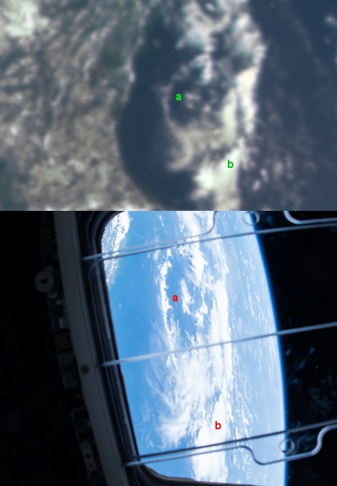
I added the letters to help you match the cloud features.
edit on 21-7-2015 by wildespace because: (no reason given)
originally posted by: Kapusta
In 2008 a Japanese Lunar orbiter took this incredible footage of the Earth as it was completely illuminated as seen from the moon
i.imgur.com...
Is this fake to ?
Sure does look round to me ....
Earth doesn't rotate & clouds aren't moving. Horrible.
Am I to understand that at least one person in this thread is finding yet another ridiculous conspiracy theory in.......a photo of Earth?? This place
just gets worse.
what a beautiful, beautiful picture of this small dot in the universe we call home
Crikey!!! I can see 'pronto's' house in this pic.
True one mate! Look, he's on his lay back chair drinking a frothy one! Bugger me. I'm headin to SA to give him and 'Hutch' a bit of "what for".
Could've given me an invite there pronto.
True one mate! Look, he's on his lay back chair drinking a frothy one! Bugger me. I'm headin to SA to give him and 'Hutch' a bit of "what for".
Could've given me an invite there pronto.
originally posted by: NeoSpace
originally posted by: slapjacks
originally posted by: Vasa Croe
Well that is a cool pic! Thanks for the share!
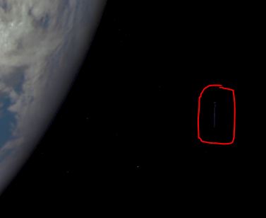
I have to say, after blowing it up, I am wondering how this long blurred line occurred with it being a series of images.
That is near the lower right of the pic. It is the only blurred line and I would think that could only occur if it was a long shutter release, yet none of the stars in the background exhibit this motion blur.
Wait for it, wait.... ALIENS!
That's the edge of the dome.
The image was generated by combining three separate images to create a photographic-quality image.
There has never ever been 1 picture of Earth from space, can't they take just 1 picture and show that without editing it.
I can't believe the number of people who gave you a star for that, it's just as well people don't have to pass an exam to join sites like ATS.
originally posted by: iDope
a reply to: wildespace
The main problem I have believing this image is the cloud coverage and that it is a composite. The clouds for one are clearly ridiculous on this day the photo was supposedly taken. You want me to believe that the only land mass visibly seen is Baja and part of SoCal? Look at the clouds over Mexico and Southern Countries, it seems the clouds are perfectly placed to cover the land, and then South America is totally blanketed by a huge cloud system, lol, what a joke.
Maybe just maybe if YOUR type put the same effort into finding out how things are done as YOU put into criticizing NASA you wouldn't make posts like that it's not a composite as people would normally think off
EPIC has an aperture diameter of 30.5 cm, f 9.38, a FOV of 0.61° and an angular sampling resolution of 1.07 arcsec. Earth apparent diameter will vary from 0.45° to 0.53° full width. Exposure time for each of the 10 narrowband channels (317, 325, 340, 388, 443, 552, 680, 688, 764 and 779 nm) is about 40 ms
It's NOT 4 partial images of Earth stitched together it's the red, green and blue channels combined to make a colour image as for the weather you can check that out as well.
That large, up-close, and detailed... from 1,000,000 miles away huh?
a reply to: Kromlech
Yes.
Your point?
Here are the camera specifications:
www.nesdis.noaa.gov...
25km per pixel.
Yes.
Your point?
Here are the camera specifications:
www.nesdis.noaa.gov...
25km per pixel.
originally posted by: wildespace
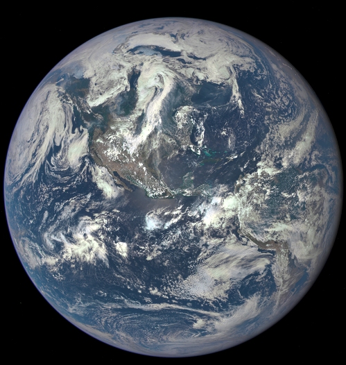
NASA have posted quite an epic and evocative image today - our planet as seen by the Deep Space Climate Observatory from one million miles away.
This color image of Earth was taken by NASA’s Earth Polychromatic Imaging Camera (EPIC), a four megapixel CCD camera and telescope. The image was generated by combining three separate images to create a photographic-quality image. The camera takes a series of 10 images using different narrowband filters -- from ultraviolet to near infrared -- to produce a variety of science products. The red, green and blue channel images are used in these color images.
This reminds me of the view of Earth Apollo astronauts had on their way to the Moon. The spacecraft is actually almost 4 times more distant from Earth than the Moon is, orbiting a point between Earth and the Sun called L1 Lagrangian point.
Source and full-size image: www.nasa.gov...
If that image was shot from 4 times the distance from Earth to the Moon, then it must be zoomed. I remember the shots from the Moon by Apollo astronauts show an Earth that appears much farther away than this shot does.
new topics
-
A duel between two cats and crows as seconds
ATS Skunk Works: 1 hours ago -
James O keefe from Veritas controlled opposition.
Medical Issues & Conspiracies: 6 hours ago -
Political Commentator Alice Stewart Supposedly Died of Natural Causes on a Sidewalk Last Night.
General Conspiracies: 6 hours ago -
BIG REVEAL | Intelligence advisor says ‘catastrophic disclosure’ about UFOs may be on horizon
Aliens and UFOs: 6 hours ago -
Madness will ensue here. Be ready.
General Chit Chat: 7 hours ago -
FO!!! FO!! FO!!...dammit!!
Food and Cooking: 8 hours ago -
The Rift
Fantasy & Science Fiction: 10 hours ago -
Would you give part of your liver to someone who needed it but could not stop drinking?
General Chit Chat: 10 hours ago
top topics
-
Cool video of bees protecting other bugs
General Chit Chat: 17 hours ago, 11 flags -
Madness will ensue here. Be ready.
General Chit Chat: 7 hours ago, 5 flags -
The horse
Jokes, Puns, & Pranks: 17 hours ago, 4 flags -
BIG REVEAL | Intelligence advisor says ‘catastrophic disclosure’ about UFOs may be on horizon
Aliens and UFOs: 6 hours ago, 4 flags -
A duel between two cats and crows as seconds
ATS Skunk Works: 1 hours ago, 4 flags -
Scientists assaulted at Skinwalker Ranch (Bigelow era)
Aliens and UFOs: 15 hours ago, 4 flags -
Political Commentator Alice Stewart Supposedly Died of Natural Causes on a Sidewalk Last Night.
General Conspiracies: 6 hours ago, 3 flags -
FO!!! FO!! FO!!...dammit!!
Food and Cooking: 8 hours ago, 3 flags -
The Rift
Fantasy & Science Fiction: 10 hours ago, 2 flags -
Would you give part of your liver to someone who needed it but could not stop drinking?
General Chit Chat: 10 hours ago, 2 flags
active topics
-
A duel between two cats and crows as seconds
ATS Skunk Works • 4 • : RussianTroll -
1st Jewish Biden Appointee to Resign Over Gaza Quits on Nakba Day
Political Issues • 86 • : gortex -
WATCH 1740 Russian Soldiers Destroyed By Ukrainian Forces While Advancing In Kharkiv
World War Three • 191 • : twistedpuppy -
A new Why Files How CRISPR and AI Destroy the World
Science & Technology • 44 • : kwaka -
I shot JFK..
Jokes, Puns, & Pranks • 36 • : BeTheGoddess2 -
Want Some Secret Knowledge?
Paranormal Studies • 46 • : SecretKnowledge2 -
Gold and silver prices....woo hoo
History • 95 • : annonentity -
Those Fake Death Numbers From Hamas Out Of Gaza
Middle East Issues • 165 • : Anouvris -
Mood Music Part VI
Music • 3232 • : BrucellaOrchitis -
BIG REVEAL | Intelligence advisor says ‘catastrophic disclosure’ about UFOs may be on horizon
Aliens and UFOs • 19 • : ARM19688