It looks like you're using an Ad Blocker.
Please white-list or disable AboveTopSecret.com in your ad-blocking tool.
Thank you.
Some features of ATS will be disabled while you continue to use an ad-blocker.

Yet another Nevada land grab
page: 1share:
www.mojavedesertblog.com...
Of particular relevance in the Mojave Desert, the version of the bill that passed the House of Representatives includes language that would offer jurisdiction of over half of the Desert National Wildlife Refuge to the U.S. Air Force for weapons testing.
Hey, people live in concrete jungles these days. So I doubt anyone will really notice.
I believe in a strong military in order to “defend” our country against those who would do us harm. But, here in the US our “leaders” are
obsessed with it. Obsessed to the point that our annual military budget is greater than the next 10 highest nation’s military budgets combined.
While our annual budget is around $600 billion, the next highest is China with around $130 billion annually. To me, that’s a strong statement in
many ways.
I’m sure there will be others who will say that it’s money well spent, and then go on about what a mighty fighting force we have; second to none. All I can say to that is we better have the biggest guns around, considering how much we spend, and sacrifice, for them. But seriously, $600 billion bucks? Might that be a teensy bit overkill? Here’s a list of countries by military expenditures for anyone whose interested.
As far as the Nevada landgrab goes, our twisted Congress places little value on such things. If it’s not green with a picture of Ben Franklin on it, and you can’t use it to blow someone else’s head off with it, it has little useful value.
I wonder if mankind will ever get it’s priorities straight. We invest more in killing our own kind than on any other endeavor. And what’s worst, we’re damned proud of it.
originally posted by: musicismagic
Hey, people live in concrete jungles these days. So I doubt anyone will really notice.
When I can't drive my SUV from Corn Creek to Alamo, I think I will notice the land grab.
I'm not convinced they won't take Tikaboo. This is a huge land grab.
I for one am tired of the NDAA of being a black hole when you bury laws the public would find offensive.
a reply to: gariac
I've wondered about Tikaboo as well since I saw your posts on landgrabs. I wouldn't be to surprised if they took that land too. Based on the view-shed analysis you can find on Dreamland Resort, taking away Tikaboo would leave only the Reveille viewspot. That would almost double the distance of the closest viewspot from 26 miles to 45 miles, and remove the advantage of a great panoramic view of the base.
Maybe you can tell me why, but I am surprised Tikaboo wasn't taken in the same landgrab that made Whitesides and Freedom Ridge offlimits. They must have known the peak existed, and from reading the first hike reports on DR someone had already been spending a lot of time up there
If some people suspicions about what's going to be living in the South hangar are right, and its a permanent outpost for someone, that may involve daytime operations? The removal of Tikaboo would make that much more secure.
originally posted by: gfad
a reply to: gariac
I've wondered about Tikaboo as well since I saw your posts on landgrabs. I wouldn't be to surprised if they took that land too. Based on the view-shed analysis you can find on Dreamland Resort, taking away Tikaboo would leave only the Reveille viewspot. That would almost double the distance of the closest viewspot from 26 miles to 45 miles, and remove the advantage of a great panoramic view of the base.
Maybe you can tell me why, but I am surprised Tikaboo wasn't taken in the same landgrab that made Whitesides and Freedom Ridge offlimits. They must have known the peak existed, and from reading the first hike reports on DR someone had already been spending a lot of time up there
If some people suspicions about what's going to be living in the South hangar are right, and its a permanent outpost for someone, that may involve daytime operations? The removal of Tikaboo would make that much more secure.
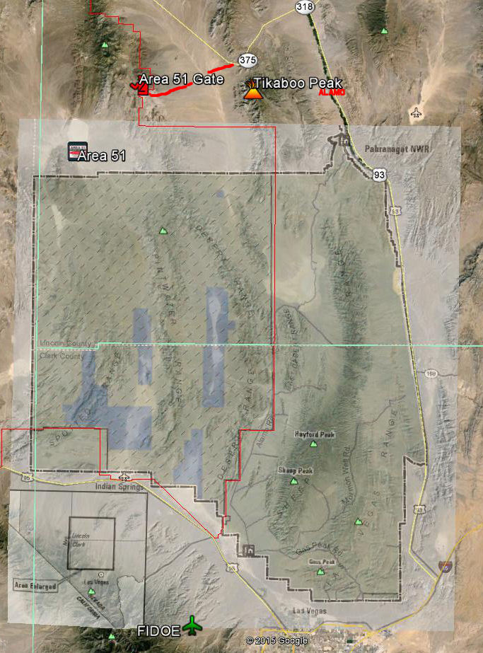
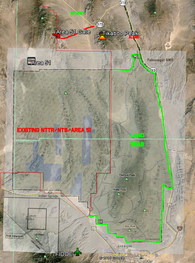
I had some trouble placing exactly where this landgrab is, so I chopped the image from the PDF, and roughly overlaid it on GE. As you can see, the northern edge falls short of Tikaboo, and JUST short of the road in there. There is a funny kind of jog at the NE corner, where the Pahranagat Wildlife Office is. Kind of looks like they are trying to eliminate access to Old Corn Creek Rd., which connects to Alamo Rd., which winds around and comes out at the south end of the range.
I didn't realize that area was closed to the public; there seems to be a fair number of pictures through there on GE/Panoramio.
I think it's only a matter of time before they grab Tikaboo.
Sign The Petition Here to Stop This Land Grab
edit on 8-7-2015 by FosterVS because: (no reason given)
a reply to: FosterVS
You can hike/drive the DNWR for now. You may or may not be able to cross the dry lake in the middle between Corn Creek and Alamo. The dry lake there is very powdery in places. The powers that be deemed the area off limits, but only the unpassable area.
What looks like a back way to Tikaboo is just that, but the road is really rough, at least when I took it.
The "normal" road to Tikaboo is maintained. By who, I don't know.
vimeo.com...
You can see a motor grader in this video.
Ok little oncufsed on the graph is the light colored box what they are trying to get/expanding or is that what they have and are trying to get more
from that?
a reply to: gfad
I have considerable viewshed analysis of the computer flavor. The link should open up google earth of your PC is set up properly. tikaboo viewshed
The Tikaboo analysis comes in handy for ham radio use.
I have considerable viewshed analysis of the computer flavor. The link should open up google earth of your PC is set up properly. tikaboo viewshed
The Tikaboo analysis comes in handy for ham radio use.
originally posted by: Keiyentai
Ok little oncufsed on the graph is the light colored box what they are trying to get/expanding or is that what they have and are trying to get more from that?
The DNWR is to the right of the NTS/NTTR. The want the DNWR as far as I can tell. I haven't got around to reading the official documents.
The NTS and the NTTR really don't like all the public access near "their" land. You can get very far into the NTS border if you are crazy enough. Search for Glen Campbell's hike to Mt. Cury.
originally posted by: Keiyentai
Ok little oncufsed on the graph is the light colored box what they are trying to get/expanding or is that what they have and are trying to get more from that?
This might be clearer, gariac correct me if this is wrong:
Sign The Petition Here to Stop This Land Grab
edit on 11-7-2015 by FosterVS because: (no reason given)
More of note in this bill:
"would make land withdrawals permanent for the Nevada Test and Training Range "
www.reviewjournal.com...
Previous land grabs (of note is the grab of Whitesides and Freedom Ridge) expired at some point. I have wondered how the military could continue to hold those lands.
gariac knows more about this than I do, perhaps he can chime in here.
originally posted by: FosterVS
More of note in this bill:
"would make land withdrawals permanent for the Nevada Test and Training Range "
BLOCKED LINK HERE - PM ME IF YOU WANT IT
Previous land grabs (of note is the grab of Whitesides and Freedom Ridge) expired at some point. I have wondered how the military could continue to hold those lands.
gariac knows more about this than I do, perhaps he can chime in here.
Interesting. Looks like links to the Las Vegas Review-Journal aren't allowed here. Stranger and stranger...
edit on 11-7-2015 by FosterVS
because: (no reason given)
a reply to: FosterVS
mt cury
Probably the side need route 95 needs work. The border there is hard to follow on the USGS topo. You can locate Mt. Cury to see how far it goes.
acme mapper
Mt. Cury apparently isn't much of a peak, so you really need to dig into the map to find it.
N36.67601 w115.95137
mt cury
Probably the side need route 95 needs work. The border there is hard to follow on the USGS topo. You can locate Mt. Cury to see how far it goes.
acme mapper
Mt. Cury apparently isn't much of a peak, so you really need to dig into the map to find it.
N36.67601 w115.95137
Tikaboo Peak in bad weather
This is what you want not to do! If there is thunder, I suggest you not climb a mountain peak.
The first photo is a fine example of virga.
virga
This is what you want not to do! If there is thunder, I suggest you not climb a mountain peak.
The first photo is a fine example of virga.
virga
Pahranagat is a lovely area. An oasis in the desert. Once did an aerial video over there and on Groom Lake Road.
originally posted by: Hauntedman
Pahranagat is a lovely area. An oasis in the desert. Once did an aerial video over there and on Groom Lake Road.
lazygranch.com...
I have a few shots of the Pahranagat lakes on the link above. These are from 98 or so, and I wasn't putting large photos on the internet back then since those were the dial up days. That and storage on the internet was measured in Mbytes back then.
The Ducks Unlimited people had messed up the lakes. I should go back and update the photos since the lakes have been back to normal, though a little low.
The page also has a shot of the sand dunes that are in the DNWR.
gariac - not sure if you saw my post above, would appreciate your input:
More of note in this bill:
"would make land withdrawals permanent for the Nevada Test and Training Range "
Previous land grabs (of note is the landgrab that took away Whitesides and Freedom Ridge) expired at some point. I have wondered how the military could continue to hold those lands. Including Base Camp.
gariac knows more about this than I do, perhaps he can chime in here.
originally posted by: gariac
originally posted by: Hauntedman
Pahranagat is a lovely area. An oasis in the desert. Once did an aerial video over there and on Groom Lake Road.
lazygranch.com...
I have a few shots of the Pahranagat lakes on the link above. These are from 98 or so, and I wasn't putting large photos on the internet back then since those were the dial up days. That and storage on the internet was measured in Mbytes back then.
The Ducks Unlimited people had messed up the lakes. I should go back and update the photos since the lakes have been back to normal, though a little low.
The page also has a shot of the sand dunes that are in the DNWR.
There is a nice, FREE campsite at Pahranagat Lakes. Right on the lake.
Good viewing of water fowl.
a reply to: FosterVS
The land grabs expire, but the BLM doesn't take the land back. I suppose you could sue to make them take the land back, but they know the USAF will then just ask for it back again. Basically the Freedom Ridge and Whitesides land grabs are expired, but expect to be arrested if you violate them.
I think Base Camp was legally renewed. They expanded the land grab a bit, so made sense to renew it. I was the only person to inspect the Base Camp expansion documents at the BLM office and got them to disallow a fence. They were going to fence off land beyond the new border, and that isn't kosher!
edit on 12-7-2015 by gariac because: (no reason given)
new topics
-
Battle of the Bay 2024 ; Tampa, Florida Special Forces Demonstration
Military Projects: 4 hours ago -
Tschugger
Movies: 5 hours ago -
Christianity superior to other faiths for very specific reasons. Awaken to true FREEDOM..!!
Conspiracies in Religions: 7 hours ago -
It's all Kicking off at Eurovision 2024
Music: 11 hours ago
top topics
-
Armadillos moving north
Fragile Earth: 15 hours ago, 9 flags -
The biggest problem with the Hush money trial
US Political Madness: 12 hours ago, 8 flags -
Million dollar idea, and good for your feelz!
Rant: 15 hours ago, 5 flags -
Christianity superior to other faiths for very specific reasons. Awaken to true FREEDOM..!!
Conspiracies in Religions: 7 hours ago, 5 flags -
Is there a dependence on the number of children in the family and its well-being?
New World Order: 15 hours ago, 4 flags -
It's all Kicking off at Eurovision 2024
Music: 11 hours ago, 4 flags -
Tschugger
Movies: 5 hours ago, 3 flags -
Battle of the Bay 2024 ; Tampa, Florida Special Forces Demonstration
Military Projects: 4 hours ago, 2 flags
active topics
-
The biggest problem with the Hush money trial
US Political Madness • 166 • : Annee -
Bibi’s Dilemma
Middle East Issues • 198 • : AliceTheSmall -
Breaking--Hamas Accepts New Cease Fire
Middle East Issues • 396 • : CarlLaFong -
Christianity superior to other faiths for very specific reasons. Awaken to true FREEDOM..!!
Conspiracies in Religions • 14 • : burritocat -
REAL ID now a reality
General Conspiracies • 39 • : EyeoftheHurricane -
-@TH3WH17ERABB17- -Q- ---TIME TO SHOW THE WORLD--- -Part- --44--
Dissecting Disinformation • 947 • : daskakik -
President Bidens Health is Declining Faster 5.8.2024 - He Should Stay Home.
2024 Elections • 44 • : Zanti Misfit -
Barron Trump has prior commitments?
Politicians & People • 97 • : Zanti Misfit -
Mood Music Part VI
Music • 3171 • : MRTrismegistus -
Is there a dependence on the number of children in the family and its well-being?
New World Order • 42 • : ToneD