It looks like you're using an Ad Blocker.
Please white-list or disable AboveTopSecret.com in your ad-blocking tool.
Thank you.
Some features of ATS will be disabled while you continue to use an ad-blocker.
3
share:
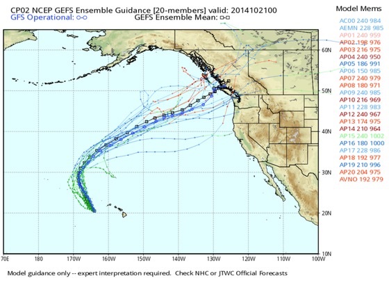
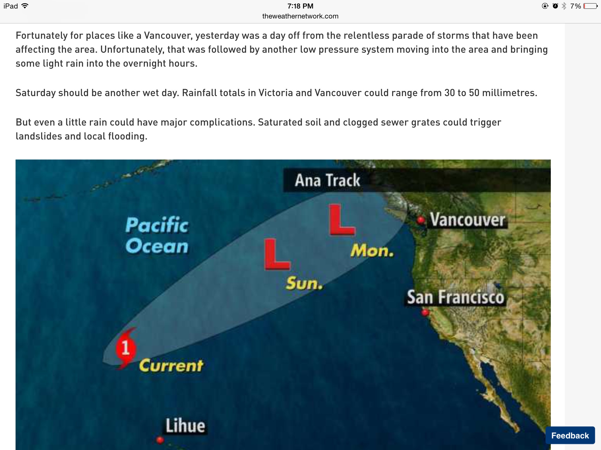
I thought this was an unusual track this hurricane is taking towards our western coastline.
Even though we typically get raging storms this time of year in the PNW ( southwest coastal for BC) this one is unusual.
Discussion # 50
It's due to make landfall around Monday evening to Tuesday afternoon on the BC Coast
It's quite stormy here to begin with, might be hard to tell when it's here as it merges with other storms. It's done nothing but rain the past week or so. Still it's something to be aware of due to the damaging winds, possibly flash flooding and mudslides. The windfield will widen even as Ana weakens. acuweather
Another interesting discussion here : weather network
Even though we typically get raging storms this time of year in the PNW ( southwest coastal for BC) this one is unusual.


Discussion # 50
It's due to make landfall around Monday evening to Tuesday afternoon on the BC Coast
It's quite stormy here to begin with, might be hard to tell when it's here as it merges with other storms. It's done nothing but rain the past week or so. Still it's something to be aware of due to the damaging winds, possibly flash flooding and mudslides. The windfield will widen even as Ana weakens. acuweather
A siege of Pacific storms will continue to drench and blast the coastal Northwest into this week and will be joined by Ana. The rounds of heavy rain will be enough to cause incidents of flash flooding, mudslides and travel delays from northern California to western Oregon, western Washington and southwestern British Columbia.
Another interesting discussion here : weather network
edit on 26-10-2014 by violet because: (no reason given)
edit on 26-10-2014 by violet because: (no reason given)
I have an interesting view point. What is the worst hurricane evar? Katrina? Maybe. I was there. It was pretty lame. Side of the apartment got tore
off, crack heads walking around in 160 mph gusts collecting scrap. Nothing serious. The water situation though
October 2014
Special weather statement in effect for:
Metro Vancouver
The remains of tropical storm Ana will approach the BC coast early in the week.
The remains of tropical storm Ana will move towards the BC coast late Monday and Tuesday. The weather associated will be typical of an intense fall storm where storm warnings are likely for the marine areas with corresponding wind warnings for coastal public regions. There will likely be heavy rainfalls as well with 50 to 100 mm possible through the period. Weather warnings are expected to be issued tomorrow.
The public is advised to monitor future forecasts and warnings as warnings may be required or extended.
environment Canada Weather
a reply to: violet
Lived through the worst of it on western Vancouver Island. Had some slight winds and heavy rainfall. Nothing compared to 2006 when my entire #in town flooded and people were kayaking down the main street. 2009 was bad too. This? this is nothing.
Lived through the worst of it on western Vancouver Island. Had some slight winds and heavy rainfall. Nothing compared to 2006 when my entire #in town flooded and people were kayaking down the main street. 2009 was bad too. This? this is nothing.
edit on 26/10/14 by SpongeBeard because: (no
reason given)
a reply to: TechniXcality
Ok thanks. Yes please check. It said it won't be a hurricane by the time it gets here but an Extratropical storm or cyclone. I don't really know the difference if it's called a cyclone. It will be over cold water as it moves North, not warm enough to sustain as a hurricane
Ok thanks. Yes please check. It said it won't be a hurricane by the time it gets here but an Extratropical storm or cyclone. I don't really know the difference if it's called a cyclone. It will be over cold water as it moves North, not warm enough to sustain as a hurricane
a reply to: SpongeBeard
The worst one I experienced here in the Fraser valley was a winter storm that came from Siberia. Power was out for days. I hsd an inch of ice inside the windows. The trees stayed bent over. It was around 1988 or ' 89
The worst one I experienced here in the Fraser valley was a winter storm that came from Siberia. Power was out for days. I hsd an inch of ice inside the windows. The trees stayed bent over. It was around 1988 or ' 89
a reply to: nukedog
Not sure how worst is classified. Usually goes by death toll and damage I would think. Katrina was bad, but that seemed more to do with the poor response. The levees broke and that fault lies with who made them: LaFarge cement, Hilary Clinton, it was alleged. It's below sea level and New Orleans was in a bad spot.
Not sure how worst is classified. Usually goes by death toll and damage I would think. Katrina was bad, but that seemed more to do with the poor response. The levees broke and that fault lies with who made them: LaFarge cement, Hilary Clinton, it was alleged. It's below sea level and New Orleans was in a bad spot.
originally posted by: violet
a reply to: nukedog
Not sure how worst is classified. Usually goes by death toll and damage I would think. Katrina was bad, but that seemed more to do with the poor response. The levees broke and that fault lies with who made them: LaFarge cement, Hilary Clinton, it was alleged. It's below sea level and New Orleans was in a bad spot.
Well as long as the national guard isn't trying to hem you in you will be perfectly fine. As soon as they or their equivalent shows up you have bigger problems than a hurricane. The Air Force though.... They straightened up the super dome real quick inside a day. Lol, it went from being a humanitarian crises to an orderly evacuation within 24 hours. I was there 5 days total. Almost got shot by our brave weekend warriors too
I'm here Ya right now its clear as a bell. Sunny tomorrow and then? I've seen all the storm types in this area but this one might get
unpredictable.
edit on 26-10-2014 by canucks555 because: (no reason given)
Well see soon enough......you couldn't tell by the beautiful sunrise this am in Campell River.....
Since i am livin on a boat i will be following this, but don't ecpect a huge problem on the east coast of the big island....
Since i am livin on a boat i will be following this, but don't ecpect a huge problem on the east coast of the big island....
originally posted by: stirling
Well see soon enough......you couldn't tell by the beautiful sunrise this am in Campell River.....
Since i am livin on a boat i will be following this, but don't ecpect a huge problem on the east coast of the big island....
Keep us posted. My family lives in Campbell river. You're not concerned with choppy waters?
I'm in the Fraser valley on the mainland. It's still raining here, bit of wind. I'm mostly expecting power outages from fallen trees and the usual turbid water from heavy rains. Our water hasn't been good to drink. It's yellow. I'm boiling it. I got super sick about a month ago on the first heavy rainfall. I wasn't aware there was an advisory. I'm not risking getting that sick again. I puked for 16 hours non stop. So my prep plans include extra stored water.
Looks like the track takes it higher up the coast near the queen charlottes.
All is calm here. Except the power went out for a minute about an hour ago
From NOAA
DISCUSSION AND 48-HOUR OUTLOOK
At 500 am HST, 1500 UTC, the center of post-tropical cyclone Ana was located near latitude 42.2 north, longitude 147.9 west. The post-tropical cyclone is moving toward the east-northeast near 46 mph, 74 km/h, and this general motion is expected to continue today. A decrease in forward motion and a turn toward the east is forecast tonight and Monday as extratropical Ana interacts with another deep low to the west.
Maximum sustained winds are near 60 mph, 95 km/h, with higher gusts. Only slight weakening is forecast during the next 48 hours.
Tropical storm force winds extend outward up to 310 miles, 500 km from the center.
The estimated minimum central pressure is 992 mb, 29.30 inches.
edit on 26-10-2014 by violet because: (no reason given)
edit on 26-10-2014 by violet because: (no reason given)
Off to the store to get storm stuff. Beer, a few candles, maybe throw a roast beef in the oven. Power goes out I have sandwiches -and beer
Here's a link to buoys all along the coast:
www.theweathernetwork.com...
-pretty cool.
Here's a link to buoys all along the coast:
www.theweathernetwork.com...
-pretty cool.
edit on 27-10-2014 by canucks555 because: (no reason given)
For newly homeless people this can be dangerous if they can't find shelter from the wind and rain. In the fall and early winter seasons, the PNW
usually gets pounded by wind and rain and temperatures commonly between 20 and 60 fahrenheit. Temperatures in this range can lead to hypothermia if
the person is wet for the requisite period of time. In the PNW, it's very easy to get wet! Fall and winter are the hardest times for the homeless in
the PNW.
People who've been homeless for a while tend to know about this better than "noobies", but it comes at tremendous cost.
People who've been homeless for a while tend to know about this better than "noobies", but it comes at tremendous cost.
edit on 27-10-2014 by
jonnywhite because: (no reason given)
Solander Islands, BC rec 133 km/gusts.#bcstorm is just getting started.
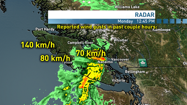
twitter.com...
edit on 27-10-2014 by canucks555 because: (no reason given)
new topics
-
This is an interesting picture. Do we actually pick our leaders?
Politicians & People: 1 hours ago -
U.S. Govt Agencies That Protect Criminals in Government - National Archives Records Admin-NARA.
Political Conspiracies: 2 hours ago -
Trump says ownership of Greenland 'is an absolute necessity'
Other Current Events: 4 hours ago -
An Updated China Navy Analysis and the Challenges of their AI/Drone Development
Military Projects: 5 hours ago -
University looking for gender diverse kids to play with transgender dolls for research
Social Issues and Civil Unrest: 6 hours ago -
FAA Investigates Christmas Drone Show Gone Wrong in Orlando, FL 12/2024
Other Current Events: 6 hours ago -
Mass Extinctions May Hold the Key to Life in the Universe
Education and Media: 10 hours ago
top topics
-
University looking for gender diverse kids to play with transgender dolls for research
Social Issues and Civil Unrest: 6 hours ago, 9 flags -
RIP Merrily Harpur British Big Cat Realist
Cryptozoology: 14 hours ago, 7 flags -
This is an interesting picture. Do we actually pick our leaders?
Politicians & People: 1 hours ago, 7 flags -
Trump says ownership of Greenland 'is an absolute necessity'
Other Current Events: 4 hours ago, 6 flags -
U.S. Govt Agencies That Protect Criminals in Government - National Archives Records Admin-NARA.
Political Conspiracies: 2 hours ago, 5 flags -
Can we be certain that Jesus Christ was born on December 25th?
Religion, Faith, And Theology: 12 hours ago, 4 flags -
Mass Extinctions May Hold the Key to Life in the Universe
Education and Media: 10 hours ago, 4 flags -
FAA Investigates Christmas Drone Show Gone Wrong in Orlando, FL 12/2024
Other Current Events: 6 hours ago, 4 flags -
An Updated China Navy Analysis and the Challenges of their AI/Drone Development
Military Projects: 5 hours ago, 3 flags
active topics
-
Trump says ownership of Greenland 'is an absolute necessity'
Other Current Events • 13 • : xuenchen -
NYPD arrests migrant who allegedly set woman on fire on subway train, watched her burn to death
Breaking Alternative News • 32 • : WeMustCare -
Panamanian President-“every square meter” of the Panama Canal belongs to Panama.
New World Order • 32 • : NoCorruptionAllowed -
University looking for gender diverse kids to play with transgender dolls for research
Social Issues and Civil Unrest • 21 • : WeMustCare -
President-elect TRUMP Picks MATT GAETZ for his ATTORNEY GENERAL - High Level PANIC Ensues.
2024 Elections • 134 • : lilzazz -
U.S. Govt Agencies That Protect Criminals in Government - National Archives Records Admin-NARA.
Political Conspiracies • 5 • : WeMustCare -
Spiritual Solstice
Short Stories • 15 • : argentus -
The Effects of Electric Fields and Plasma on Plant Growth
Science & Technology • 9 • : bscotti -
RIP Merrily Harpur British Big Cat Realist
Cryptozoology • 3 • : bscotti -
Australian mercenary caught and crying as he is a prisoner of war.
Other Current Events • 38 • : annonentity
3
