It looks like you're using an Ad Blocker.
Please white-list or disable AboveTopSecret.com in your ad-blocking tool.
Thank you.
Some features of ATS will be disabled while you continue to use an ad-blocker.

Heavy Spraying on Vancouver Island
page: 3share:
originally posted by: cass1dy09
These were all taken by me within the past 2 weeks on the southern tip of Vancouver Island BC Canada. Contrails you say? There isn't an airport within 40km. All pics seem to have a similarity, they are trying to block the sun. You can see when the trail disperses it leaves a large wave that briefly blocks the sun for 45 minutes to an hour.
Blocks the sun not doing a very good job then are they, aircraft have to descend to land! and contrails are usually a sign they are at 25,000 ft + so OBVIOUSLY not going to an airport near you.
Here is a nice image for YOU
Now that is cirrus clouds they look a bit like your spread out contrails don't they and can form at a similar height as your contrails and spread out like them as well so what makes that happen with the clouds is it MOTHER NATURE trying to block the sun for you or is it simply the air currents at that altitude
Here is a video showing a days worth of worldwide air traffic in one minute.
Now do you understand why so many aircraft pass over you
originally posted by: VoidFire
originally posted by: network dude
a reply to: VoidFire
Enjoy the memory thing while it lasts. the old grey matter turns to mush when you get older.
Also, the conditions at altitude can be vastly different than the ground. It's how you can forecast storm fronts using cirrus clouds to some degree of accuracy. (you probably already know that, but I wanted to point that out for others)
I majored partly in Geography while in college
Did you do well? And how is that relevant?
Not the end of the world but
originally posted by: VoidFire
The Photos seem to all have been taken around the Langford area of the Captial Regional District of Victoria, here in BC. The nearest airport being YYJ is about an hour's drive away from this general area, given good traffic.
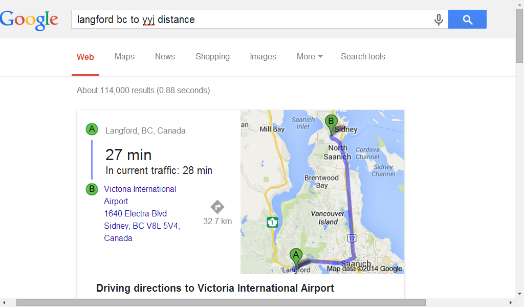
As the crow flies, YYJ looks to be only about 15 miles from Langford. The proximity doesn't really matter to the topic but I'm baffled as to why so many think it does and have even tried to increase the perception of the distance for some reason.
a reply to: VoidFire
Here is a good thread that discusses that very topic.
www.abovetopsecret.com...
Enjoy.
Though in regards to what I saw in my youth, my memories involving the contrails were Summer centric, when the humidity in the area was fairly low, so that would be a factor.
Here is a good thread that discusses that very topic.
www.abovetopsecret.com...
Enjoy.
originally posted by: DenyObfuscation
originally posted by: VoidFire
originally posted by: network dude
a reply to: VoidFire
Enjoy the memory thing while it lasts. the old grey matter turns to mush when you get older.
Also, the conditions at altitude can be vastly different than the ground. It's how you can forecast storm fronts using cirrus clouds to some degree of accuracy. (you probably already know that, but I wanted to point that out for others)
I majored partly in Geography while in college
Did you do well? And how is that relevant?
Not the end of the world but
originally posted by: VoidFire
The Photos seem to all have been taken around the Langford area of the Captial Regional District of Victoria, here in BC. The nearest airport being YYJ is about an hour's drive away from this general area, given good traffic.
As the crow flies, YYJ looks to be only about 15 miles from Langford. The proximity doesn't really matter to the topic but I'm baffled as to why so many think it does and have even tried to increase the perception of the distance for some reason.
Well, yes I did do well in geography while in College. I've since graduated and have a degree. What matters is that it's helped me gain an understanding of atmospheric phenomena. In any case, that comment wasn't directed to you and was more a happy comment of understanding to whom it was directed.
The distance to the airport doesn't matter, what matters is that many flights fly over the Island in General, as it does for anywhere else.
I admit I may of made an early judgement by the title I chose, but I haven't been convinced otherwise I'm wrong thus far.
a reply to: cass1dy09
Looks like clouds to me. It also looks like the camera is overcompensating on the exposure level due to the bright light in the top of the frame, resulting in the vivid patternation. Looking at the bottom half of the frame it looks as though contrast and presence have also been boosted (this may be an automatic function of the camera)
I've seen this happen on pictures of my own.
edit on 12-7-2014 by waynos because: (no reason given)
a reply to: cass1dy09
That's why it's called a forecast and not a guarantee....
Are those clouds normal is that what you are asking, because if it is here you go...
www.clouds-online.com...
New pic. Suppose to be sunny today 30c with no clouds. Is this normal, anyone?
That's why it's called a forecast and not a guarantee....
Are those clouds normal is that what you are asking, because if it is here you go...
www.clouds-online.com...
new topics
-
An Implausible New Electoral Process?
Political Ideology: 1 hours ago -
A Couple Of Great Movies Ive Watched Today
General Chit Chat: 2 hours ago -
WHY is DOJ Not Turning Over the AUDIO of JOE BIDENs Sworn Testimony to Prosecutor Robert Hur.
Above Politics: 2 hours ago -
Boeing 737 Max whistleblower Joshua Dean, 45, dead after sudden illness
Whistle Blowers and Leaked Documents: 2 hours ago -
Bigger than Covid
US Political Madness: 6 hours ago -
Modern Mind Control
General Conspiracies: 9 hours ago -
Trump Warns Time Magazine of Rising Anti-White Sentiment
2024 Elections: 11 hours ago -
Illegal Immigration Outlawed in Oklahoma Starting July 1
Social Issues and Civil Unrest: 11 hours ago -
California Must Spend 20 Billion on Power Grid Upgrades If It Wants EVs
Fragile Earth: 11 hours ago -
Young People Now Identifying as 'Gender Season' - seasogender, gender season, or gendersian
Social Issues and Civil Unrest: 11 hours ago
top topics
-
Illegal Immigration Outlawed in Oklahoma Starting July 1
Social Issues and Civil Unrest: 11 hours ago, 19 flags -
Two lifeforms merge into one for first time in a billion years
Science & Technology: 12 hours ago, 13 flags -
Bigger than Covid
US Political Madness: 6 hours ago, 9 flags -
Trump Warns Time Magazine of Rising Anti-White Sentiment
2024 Elections: 11 hours ago, 9 flags -
WHY is DOJ Not Turning Over the AUDIO of JOE BIDENs Sworn Testimony to Prosecutor Robert Hur.
Above Politics: 2 hours ago, 7 flags -
California Must Spend 20 Billion on Power Grid Upgrades If It Wants EVs
Fragile Earth: 11 hours ago, 6 flags -
Modern Mind Control
General Conspiracies: 9 hours ago, 6 flags -
A Couple Of Great Movies Ive Watched Today
General Chit Chat: 2 hours ago, 4 flags -
Boeing 737 Max whistleblower Joshua Dean, 45, dead after sudden illness
Whistle Blowers and Leaked Documents: 2 hours ago, 4 flags -
Cambridge professor founds signs of life on another planet
Aliens and UFOs: 17 hours ago, 3 flags
active topics
-
Modern Mind Control
General Conspiracies • 16 • : Zanti Misfit -
Rendlesham Forest 1980 Pt II - Will There Be An Answer?
Aliens and UFOs • 3658 • : Ophiuchus1 -
WHY is DOJ Not Turning Over the AUDIO of JOE BIDENs Sworn Testimony to Prosecutor Robert Hur.
Above Politics • 6 • : Zanti Misfit -
Trump Warns Time Magazine of Rising Anti-White Sentiment
2024 Elections • 46 • : Zanti Misfit -
International law versus "rules-based order"
New World Order • 43 • : YouSir -
Candidate TRUMP Now Has Crazy Judge JUAN MERCHAN After Him - The Stormy Daniels Hush-Money Case.
Political Conspiracies • 1017 • : WeMustCare -
ALERT - U.S. President JOE BIDEN Examined and Found NOT OF SOUND MIND.
2024 Elections • 69 • : Zanti Misfit -
A Couple Of Great Movies Ive Watched Today
General Chit Chat • 7 • : Almanec -
California Must Spend 20 Billion on Power Grid Upgrades If It Wants EVs
Fragile Earth • 23 • : Zanti Misfit -
Cambridge professor founds signs of life on another planet
Aliens and UFOs • 7 • : Almanec