It looks like you're using an Ad Blocker.
Please white-list or disable AboveTopSecret.com in your ad-blocking tool.
Thank you.
Some features of ATS will be disabled while you continue to use an ad-blocker.

Wild Wyoming cloud wows weatherwatchers
page: 1share:
This is both really cool and really frightening
I have traveled extensively all over the United States and even abroad and I have seen my share of strange weather but nothing like this..
Semper
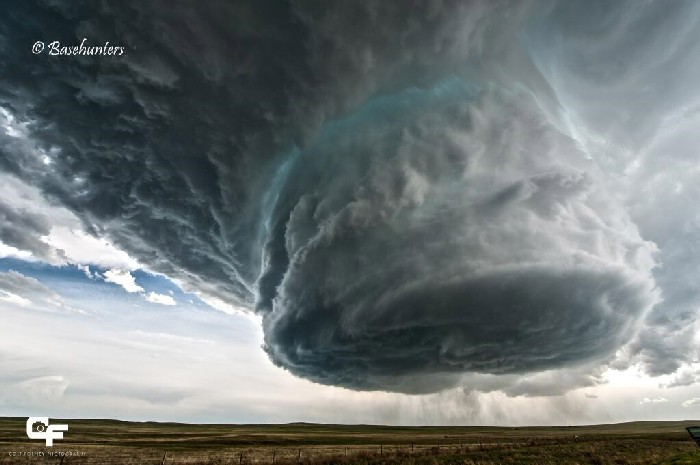
A phenomenal shot of a massive cloud Sunday near Clareton, Wyo., has been making the rounds on social media today.
The photo was taken by the Basehunters storm chasers group, who are "committed to capturing the most unique and close-up tornado footage on the market," according to their Facebook page. It shows the rotating updraft of a supercell thunderstorm over eastern Wyoming, according to Weather Channel meteorologist Jon Erdman.
Supercells are the largest, strongest and longest-lasting thunderstorms. They are most common on the Great Plains.
Known as a "low-precipitation" supercell, these types of storms seldom produce heavy rain or tornadoes, though they can produce large hail, Erdman said.
I have traveled extensively all over the United States and even abroad and I have seen my share of strange weather but nothing like this..
Semper
I'm glad the clouds where i live are normal, if i see that i would start to dig a hole to hide from the imminent tornado/wrath of god.
I dont know what else to say other that "ohhhhhh cooooooooooool"
So pretty and also a bit threatening
So pretty and also a bit threatening
a reply to: semperfortis
How stunningly beautiful. Nature is so alive and full of movement at this time on earths history, our shared history. That cloud reminds me of ice cream and I want to lick it... JK.
Everything is in flux and we will all begin to witness things we have never before even imagined. Thank you for sharing.
a reply to: semperfortis
Saw an awesome time-lapse video of this this morning:
www.iflscience.com...
Enjoy
Saw an awesome time-lapse video of this this morning:
www.iflscience.com...
Enjoy
That would definitely cause me to "Chicken Little" in my pants.
Damn nature... You scary.
S&F as long as they keep it over there. Seeing something like that smacks you in the face with how little control you have and how very tiny we are on this planet.
Damn nature... You scary.
S&F as long as they keep it over there. Seeing something like that smacks you in the face with how little control you have and how very tiny we are on this planet.
edit on 5/20/2014 by Kangaruex4Ewe because: (no reason given)
Storms can create some crazy looking things. It's really amazing. I'd love to see some of these in real life.
These two were from a storm in Kansas a bit over a week ago.
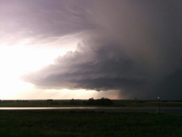
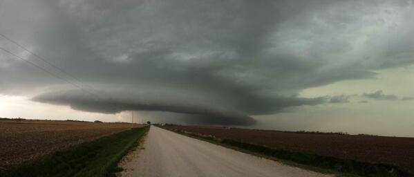
These two were from a storm in Kansas a bit over a week ago.
I've not seen a cloud that looks like that. It looks like a cloaked UFO that came down from the atmosphere. -Not saying that's what it is...
The storm that hit my town a couple years ago was the strangest thing that I've ever seen. I watched these black-mist clouds cover the area very quickly, then came winds over 90mph. I knew the second that I saw those clouds that something was not right and I got my family to a safe place(we were in a vehicle). I had a thread about it. I'm 42 and have seen a lot of storms and crazy weather but have never seen anything like that. I've heard many other people who were there say the same thing.
The storm that hit my town a couple years ago was the strangest thing that I've ever seen. I watched these black-mist clouds cover the area very quickly, then came winds over 90mph. I knew the second that I saw those clouds that something was not right and I got my family to a safe place(we were in a vehicle). I had a thread about it. I'm 42 and have seen a lot of storms and crazy weather but have never seen anything like that. I've heard many other people who were there say the same thing.
a reply to: semperfortis
I'll give you an S&F just for the headline. It reminds me of the wacky headlines from SimCity. Amazing photograph of the cloud too.
I'll give you an S&F just for the headline. It reminds me of the wacky headlines from SimCity. Amazing photograph of the cloud too.
Lived in the Great Plains for about half of my life. Ive seen up to four tornados touch down at the same time. Cloud formations not unlike the one
filmed and even stranger. I had the opportunity to look up into an F1 as it was forming directly overhead...the beauty is indescribable. It finally
touched down about two miles away, didnt cause much damage luckily.
originally posted by: Topsie
a reply to: semperfortis
Saw an awesome time-lapse video of this this morning:
www.iflscience.com...
Enjoy
Thank you.
Amazing!
Here I'll post it as well:
edit on 5/20/2014 by muzzleflash because: (no reason given)
a reply to: semperfortis
EPIC!
I know that super cell storms are dangerous in that they can create tornado winds and death and carnage related thereto, but I think despite that, I would love to see something like that up close. Such an awe inspiring image! I cannot imagine what it must have been like to be close to that vast twirling behemoth!
The God of Thunder has noted your appreciation of his work. Everybody loves to be appreciated.
Dang it Semper I want that bigger where is a link to the original? That is AWESOME!
a reply to: muzzleflash
Heh... if it ever comes up, you are more than welcome to my spare pair. Natural displays of the awesome fury of this planet, our world, have always filled me with more awe and wonder, than fear and despair! When the weather gets stupid down here, to the minimal degree that it ever does, while everyone around me runs for some sort of cover from the wind or rain, or snow... I am out getting a face full and loving it.
That said, I might have somewhat more concern for my physical body in the event of a tornado touch down But big columns of cloud? Nah, that is some straight up biblical crap. I would LOVE to see that!
a reply to: TrueBrit
I actually had a bad dream once about 10 years ago where all of these pillars came down from the clouds, like the one in the photos here. But they came all the way down to the ground I think, and were mixed with magic energies or whatever, it was a dream so it didn't have to make sense.
I can't believe I just remembered that as a result of your post.
Thanks for the nightmare nostalgia!
It's a good thing I come to ATS and discover these things are normal, because if I ever saw that without knowing I'd be scared to death!
new topics
-
DARPA Releases First Images Of Manta Ray Underwater Drone During In-Water Testing
Military Projects: 5 hours ago -
I'm back...sort of
Introductions: 5 hours ago -
October 7th: The Crumbling Facade of a Western Security Asset
Above Politics: 7 hours ago -
Echoes of Colonialism: The Struggle for Space and Speech in Academic Institutions
US Political Madness: 7 hours ago -
VIDEO INSIDE CIA: Project Manager Says Execs and Directors of CIA Withheld Information From Trump
US Political Madness: 8 hours ago -
Richard Tandy ELO R.I.P.
Music: 10 hours ago
top topics
-
ICJ Did NOT Find There Was a Plausible Case That Israel Is Committing Genocide
World War Three: 12 hours ago, 11 flags -
White House considers welcoming some Palestinians from war-torn Gaza as refugees
US Political Madness: 16 hours ago, 10 flags -
DARPA Releases First Images Of Manta Ray Underwater Drone During In-Water Testing
Military Projects: 5 hours ago, 7 flags -
I'm back...sort of
Introductions: 5 hours ago, 5 flags -
VIDEO INSIDE CIA: Project Manager Says Execs and Directors of CIA Withheld Information From Trump
US Political Madness: 8 hours ago, 4 flags -
The Pentagon is lying about UFOs
Aliens and UFOs: 12 hours ago, 3 flags -
Israel's plans for the West
Above Politics: 12 hours ago, 3 flags -
October 7th: The Crumbling Facade of a Western Security Asset
Above Politics: 7 hours ago, 3 flags -
Richard Tandy ELO R.I.P.
Music: 10 hours ago, 3 flags -
Who I am is me.
Introductions: 15 hours ago, 2 flags
active topics
-
Krystalnacht on today's most elite Universities?
Social Issues and Civil Unrest • 46 • : SchrodingersRat -
White House considers welcoming some Palestinians from war-torn Gaza as refugees
US Political Madness • 36 • : Asher47 -
James O’Keefe: I have evidence that exposes the CIA, and it’s on camera.
Whistle Blowers and Leaked Documents • 46 • : SchrodingersRat -
The Pentagon is lying about UFOs
Aliens and UFOs • 13 • : Jukiodone -
Civil War in Texas Say Chinese Media
General Conspiracies • 62 • : SchrodingersRat -
College protesters want amnesty.
US Political Madness • 192 • : RAY1990 -
Richard Tandy ELO R.I.P.
Music • 5 • : angelchemuel -
German city in chaos as 'extremist' march sees calls for 'caliphate' and ISIS-style flags
Mainstream News • 43 • : SchrodingersRat -
Echoes of Colonialism: The Struggle for Space and Speech in Academic Institutions
US Political Madness • 26 • : Asher47 -
Hard evidence of a Royal plot on the US....if only i had proof.
ATS Skunk Works • 85 • : angelchemuel