It looks like you're using an Ad Blocker.
Please white-list or disable AboveTopSecret.com in your ad-blocking tool.
Thank you.
Some features of ATS will be disabled while you continue to use an ad-blocker.
8
share:
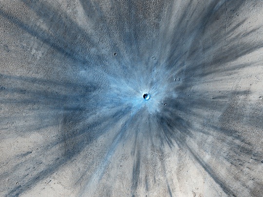
Amazing new high res pictures have came out of an impact crater on Mars that hit between 2010-2012.

From the Article.
Currently this is the dimensions of the crater:
-30 Meters in Diameter
-15km Debris field.
Will be interesting to see some higher resolution photos.
-NexusNews

From the Article.
NASA has announced the discovery of a fresh impact crater on Mars, and has released eye-popping pictures of the new hole taken by the Mars Orbiter's High Resolution Imaging Science Experiment (HiRISE).
Source
Currently this is the dimensions of the crater:
-30 Meters in Diameter
-15km Debris field.
Will be interesting to see some higher resolution photos.
-NexusNews
How come that 30m number doesn't sound right when looking at the pic and then the subsequent statement the debris field is 15km? That crater is +-
100ft across? Something doesn't appear to be right.
reply to post by Bilk22
30 meter crater with a 15,000 meter debris field, You cannot see the complete debris field in the image but it seems about right.
30 meter crater with a 15,000 meter debris field, You cannot see the complete debris field in the image but it seems about right.
I don't know. The numbers don't seem to make sense. If you use the diameter of the crater as a scale, the left edge of that pic is approximately 1600ft from the crater's edge. They're claiming the debris field extends 50,000ft beyond the crater. From looking at that splash in the terrain, the numbers and the pic don't seem to match. But what do I know?
flammadraco
reply to post by Bilk22
30 meter crater with a 15,000 meter debris field, You cannot see the complete debris field in the image but it seems about right.
reply to post by Bilk22
The debris field would include material other than the rays of dust you can see in the image. We are only looking at the "blast zone". Ejecta is thrown much greater distances.
hirise-pds.lpl.arizona.edu...
The debris field would include material other than the rays of dust you can see in the image. We are only looking at the "blast zone". Ejecta is thrown much greater distances.
hirise-pds.lpl.arizona.edu...
edit on 2/6/2014 by Phage
because: (no reason given)
OK fair enough, but then that's one tiny hole in the ground - 100' across. Now I want to ask, why, if they can take an image of that resolution and send it back to mother Earth, are Curiosity's pics so miserable? Isn't the camera for that satellite older tech than that on Curiosity?
Phage
reply to post by Bilk22
The debris field would include material other than the rays of dust you can see in the image. We are only looking at the "blast zone". Ejecta is thrown much greater distances.
hirise-pds.lpl.arizona.edu...edit on 2/6/2014 by Phage because: (no reason given)
reply to post by Bilk22
Well that's an interesting change of topic.
I don't think the MSL images are particularly "miserable" but here are the specs for the Mastcam, maybe that will help.
I don't think that HIRISE can get 150 µm resolution at 2 meters (or any distance). You see, the instruments are designed for entirely different things.
msl-scicorner.jpl.nasa.gov...
Well that's an interesting change of topic.
I don't think the MSL images are particularly "miserable" but here are the specs for the Mastcam, maybe that will help.
The M-100 IFOV is 7.4 × 10^-5 radians, yielding 7.4 cm/pixel scale at 1 km distance and ~150 µm/pixel scale at 2 m distance.
I don't think that HIRISE can get 150 µm resolution at 2 meters (or any distance). You see, the instruments are designed for entirely different things.
msl-scicorner.jpl.nasa.gov...
edit on 2/6/2014 by Phage because: (no reason given)
Sort of the same topic as I see it. Isn't the mastcam intended to take pics of distant terrain? Wouldn't it be beneficial to have hi-res pics of that distant terrain, similar to that of the orbiter satellite? Or are we not privy to those pics?
Phage
reply to post by Bilk22
Well that's an interesting change of topic.
I don't think the MSL images are particularly "miserable" but here are the specs for the Mastcam, maybe that will help.
The M-100 IFOV is 7.4 × 10^-5 radians, yielding 7.4 cm/pixel scale at 1 km distance and ~150 µm/pixel scale at 2 m distance.
I don't think that HIRISE can get 150 µm resolution at 2 meters (or any distance). You see, the instruments are designed for entirely different things.
msl-scicorner.jpl.nasa.gov...edit on 2/6/2014 by Phage because: (no reason given)
If this object had impacted Earth I suppose it would probably have exploded in the atmosphere like the Chelyabinsk object did, as the article in the
OP implies. Our atmosphere is apparently good for more than just breathing.
hirise.lpl.arizona.edu...
It says 30cm per pixel at 300km, so if you divide both those by 300 you get the equivalent of 0.1cm per pixel at 1km, which you can sort of compare to the MastCam specifications at 1km which aren't that good. I have to agree that the 1200x1200 pixels mastcam resolution (about 1.44megapixels) does seem to be pretty modest resolution and I don't have a good explanation for why an image sensor with more pixels wasn't used in the mastcams.
Yes HiRISE takes pictures from a greater distance but you can still compare by normalizing angular resolution and on that basis HiRISE does appear to have sharper pictures and specifications.
Phage
The M-100 IFOV is 7.4 × 10^-5 radians, yielding 7.4 cm/pixel scale at 1 km distance and ~150 µm/pixel scale at 2 m distance.
I don't think that HIRISE can get 150 µm resolution at 2 meters (or any distance). You see, the instruments are designed for entirely different things.
hirise.lpl.arizona.edu...
It says 30cm per pixel at 300km, so if you divide both those by 300 you get the equivalent of 0.1cm per pixel at 1km, which you can sort of compare to the MastCam specifications at 1km which aren't that good. I have to agree that the 1200x1200 pixels mastcam resolution (about 1.44megapixels) does seem to be pretty modest resolution and I don't have a good explanation for why an image sensor with more pixels wasn't used in the mastcams.
Bilk22
Isn't the mastcam intended to take pics of distant terrain?
HiRISE is basically a telescope, while the rover's cameras were never designed as such. One of the Mastcam cameras is telescopic, but the rover's main job is to analyse what's near it, specially what it can reach with its robotic arm. The telescopic Matscam is good for capturing the surroundings in general and looking ahead for possible targets, but it is rover's "hands on" instruments that matter the most. When every gram of weight, and every bit of energy consumption is at stake, I don't think huge hi-res panoramas or distant views are the priority here.
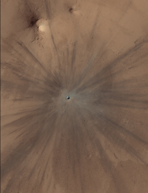
By the way, here's the crater in RGB colours (close to natural, but still not 100% genuine). hirise-pds.lpl.arizona.edu...

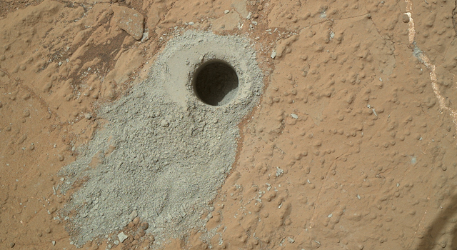
I imagine the material in the crater to be grey rock, similar to what Curiosity drilled out.
(MAHLI camera image, which provides the closest to natural-looking colours)

Mars' red appearance is due to the thin layer of iron oxide dust, but beneath it is grey rock and dark basaltic sands.
More about colours in HiRISE images: hirise.lpl.arizona.edu...
reply to post by Arbitrageur
Pixel count is not as important as other factors....like a long (telescopic) lens. That's why the mastcams can get very good resolution in the near field.
Seeing distant objects in detail is not really a mission critical requirement. Adding optics adds weight.
I have to agree that the 1200x1200 pixels mastcam resolution (about 1.44megapixels) does seem to be pretty modest resolution and I don't have a good explanation for why an image sensor with more pixels wasn't used in the mastcams.
Pixel count is not as important as other factors....like a long (telescopic) lens. That's why the mastcams can get very good resolution in the near field.
Seeing distant objects in detail is not really a mission critical requirement. Adding optics adds weight.
edit on 2/7/2014 by Phage because: (no reason given)
reply to post by Phage
Yes optics are heavy, but image sensors with more pixels are not so heavy. You can't logically argue that the number of pixels is based on the focal length (optics) because both the 34mm and 100 mm focal length optics on the mastcams have 1200x1200 pixel resolution.
Edit to add: Found this explanation for why they used the moderate resolution sensors, and apparently it's not an issue with optics. Sounds like maybe bandwidth and uncertainty about the reliability of higher resolution sensors available at the time:
NASA explains why they chose a 2 megapixel camera for Curiosity
edit on 7-2-2014 by Arbitrageur because: clarification
reply to post by Arbitrageur
Without the optics it really doesn't really matter how many pixels you've got. The Mark I imaging system (human eyeball) has a lot of "pixels" but without extra optics you're not going to see high detail in distant objects. You need the glass to get the zoom. Put more glass in front of those "low rez" sensors and you would get the pictures that the anomaly hunters demand. And add weight and have to sacrifice something for it.
Of course not. Sensors and optics are two separate issues. If they wanted to have a really good view of distant objects, if it were important to the mission, they would have put higher powered optics on the mastcams.
Edit to add: Found this explanation for why they used the moderate resolution sensors, and apparently it's not an issue with optics.
Without the optics it really doesn't really matter how many pixels you've got. The Mark I imaging system (human eyeball) has a lot of "pixels" but without extra optics you're not going to see high detail in distant objects. You need the glass to get the zoom. Put more glass in front of those "low rez" sensors and you would get the pictures that the anomaly hunters demand. And add weight and have to sacrifice something for it.
edit on 2/7/2014 by Phage because: (no reason given)
new topics
-
Well this is Awkward .....
Mainstream News: 3 hours ago -
Kurakhove officially falls. Russia takes control of major logistics hub city in the southeast.
World War Three: 5 hours ago -
Liberal Madness and the Constitution of the United States
US Political Madness: 11 hours ago
top topics
-
Well this is Awkward .....
Mainstream News: 3 hours ago, 15 flags -
Liberal Madness and the Constitution of the United States
US Political Madness: 11 hours ago, 10 flags -
Kurakhove officially falls. Russia takes control of major logistics hub city in the southeast.
World War Three: 5 hours ago, 8 flags
active topics
-
-@TH3WH17ERABB17- -Q- ---TIME TO SHOW THE WORLD--- -Part- --44--
Dissecting Disinformation • 3828 • : Thoughtful3 -
Trump says ownership of Greenland 'is an absolute necessity'
Other Current Events • 58 • : matafuchs -
NYPD arrests migrant who allegedly set woman on fire on subway train, watched her burn to death
Breaking Alternative News • 58 • : BernnieJGato -
Plane Crash Today --Azerbaijanian E190 passenger jet
Mainstream News • 46 • : Flyingclaydisk -
This is why ALL illegals who live in the US must go
Social Issues and Civil Unrest • 31 • : yuppa -
Mood Music Part VI
Music • 3768 • : Hellmutt -
Well this is Awkward .....
Mainstream News • 18 • : Myhandle -
Elon Musk futurist?
Dreams & Predictions • 19 • : cherokeetroy -
Meta Llama local AI system is scary good
Science & Technology • 32 • : Scratchpost -
New York Governor signs Climate Law that Fines Fossil Fuel Companies
US Political Madness • 25 • : WakeofPoseidon
8
