It looks like you're using an Ad Blocker.
Please white-list or disable AboveTopSecret.com in your ad-blocking tool.
Thank you.
Some features of ATS will be disabled while you continue to use an ad-blocker.
share:
Hey Puter, thanks for the great quake watch threads and all the info. In regards to El Hierro, they had another 5.0 plus today. Was wondering what
your take is on this island and what may or may not occur. Thanks.
Looks like an uptick in small quake activity in southern California today, particularly San Jacinto Fault zone. A few in (yes, IN) and around Salton
Sea too. Surprisingly though just one west of the southern end of the Elsinore Fault zone.
I currently count 23 between Brawley and Riverside / San Bernardino. Haven't felt any of them though.
As I was typing this, this one popped up, so make it 24:
*edit to add- didn't realize this was 2014 thread so my apologies. Moderator may delete if desired.
I currently count 23 between Brawley and Riverside / San Bernardino. Haven't felt any of them though.
As I was typing this, this one popped up, so make it 24:
M 1.2 - 2km ENE of Anza, California
Time 2013-12-30 20:28:45 UTC-08:00
Location33.565°N 116.655°W
Depth2.7km
*edit to add- didn't realize this was 2014 thread so my apologies. Moderator may delete if desired.
edit on 12/30/2013 by abecedarian because: (no reason given)
reply to post by Rezlooper
El Hierro is of course the newest part of a line of an ongoing hotspot so whether in our brief lifespans of in the geological blink of an eye, or a bit longer, you can rest assured that there will be more earthquakes and more activity and indeed new islands.
In regards to El Hierro, they had another 5.0 plus today. Was wondering what your take is on this island and what may or may not occur. Thanks.
El Hierro is of course the newest part of a line of an ongoing hotspot so whether in our brief lifespans of in the geological blink of an eye, or a bit longer, you can rest assured that there will be more earthquakes and more activity and indeed new islands.
reply to post by abecedarian
Hardly a problem since somewhere in the world it is now 2014, which may explain Muzzy's absence! Probably too busy tying one on at the bottom of the world!
edit to add- didn't realize this was 2014 thread so my apologies. Moderator may delete if desired
Hardly a problem since somewhere in the world it is now 2014, which may explain Muzzy's absence! Probably too busy tying one on at the bottom of the world!
reply to post by PuterMan
woohoo....its about 3am in new Zealand and just past midnight here in Australia...HAPPY NEW YEAR.
so far it looks good...lol
woohoo....its about 3am in new Zealand and just past midnight here in Australia...HAPPY NEW YEAR.
so far it looks good...lol
Happy New Year everyone.
Time Zone wise this will be the first quake of 2014, Lake Taupo (super volcano)
9:46 minutes in.
Subject to revision to UTC time when it rolls around in 8 hrs, there will perhaps be another winner.
Time Zone wise this will be the first quake of 2014, Lake Taupo (super volcano)
9:46 minutes in.
Subject to revision to UTC time when it rolls around in 8 hrs, there will perhaps be another winner.
Public ID 2013p985153
Universal Time December 31 2013 at 12:09:46
NZ Daylight Time Wednesday, January 1 2014 at 1:09:46 am
Latitude, Longitude -38.87, 175.94
Intensity ? unnoticeable
Focal Depth 84 km
Magnitude 2.1
Location 20 km north-east of Turangi
Agency WEL(GNS_Primary)
Status ? automatic
Quality ? caution
www.geonet.org.nz...
reply to post by muzzy
Oh great! I was just writing about Lake Taupo on another thread! I take it ole Taupo does have little shuffties like this every now and again, or should we be going into 2014 worrying about the big mama?
Rainbows
Jane
Oh great! I was just writing about Lake Taupo on another thread! I take it ole Taupo does have little shuffties like this every now and again, or should we be going into 2014 worrying about the big mama?
Rainbows
Jane
Happy New Year Puterman and welcome back to the helm. I don't contribute much but I'm an avid follower of Quake watch and appreciate all the time
you and Muzzy spend educatin' us seismically-challenged yet eager to learn masses!
reply to post by angelchemuel
I haven't specifically been watching Taupo, but can't say there has been much happening there for a while that I noticed.
I haven't specifically been watching Taupo, but can't say there has been much happening there for a while that I noticed.
Looks like this is the earliest UTC quake of 2014
I have checked Italy, Japan, Spain and Colombia and nothing earlier
I have checked Italy, Japan, Spain and Colombia and nothing earlier
F-E Region: Philippine Islands Region
Time: 2014-01-01 00:01:17.2 UTC
Magnitude: 4.9
Epicenter: 120.25°E 19.08°N
Depth: 10 km
Status: A - automatic
geofon.gfz-potsdam.de...
edit on 01u0014 by muzzy because: (no reason given)
Saw a 4.8 pop up for Japan and realize it's been pretty quiet so if the earth is going to let off some steam - let it be several of these smaller
ones and far out at sea.
Posting because this is one of my staple threads. Thanks for the work you do. It's up to date and there is always someone there if you feel the need to do more than read. Earthquakes can cause a lot of anxiety for some so being able to discuss them is important when the occasions arises. Lots of education in these threads and I am not aware of another place where one can find this Q & A format (Facebook but who wants to be on Facebook. Sorry - just kidding but no..really).
Anyway - Happy New Year and hope your not staying too busy this year with these (197 pages in 2013 and I cant't see how many posts but it was a lot).
reply to post by BO XIAN
An update to my comment about any unusual trends.
We all are aware of the extraordinary drop in the level of earthquakes during December of last year - only 4 Mag 6+ which must be a record for a December - and you are probably also not aware that the number of converted mag 5 quakes (see my geophysical reports for an explanation) has bottomed and is at a lower level than 2002 and probably much earlier.
I am still working my way back through those.
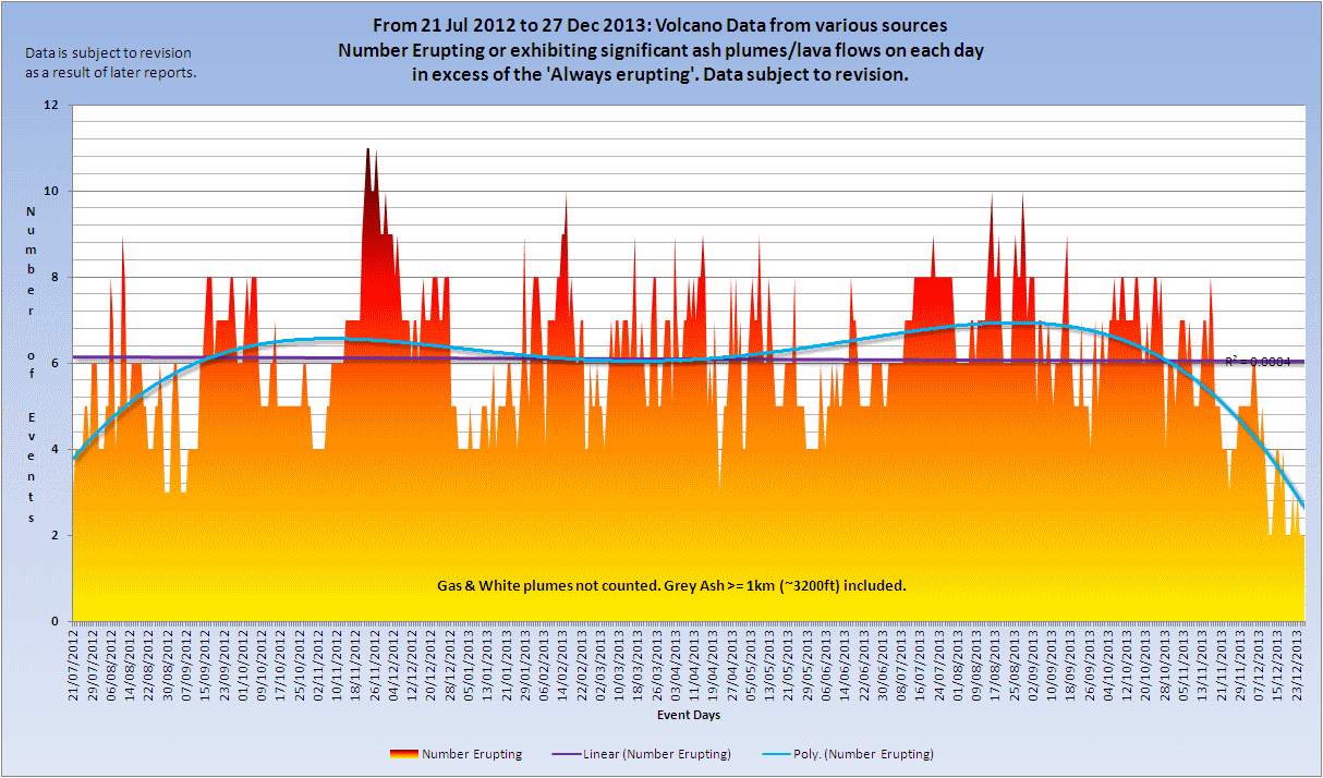
What you are probably not aware of is that the volcanic eruptions have also gone to an unprecedented low. You may not believe that from media hype but I get alerts for all Google items with the word 'volcano' or 'eruption' - which is a ton of stuff every day - and I filter that for all current reports of volcanic activity of any kind.
Assuming San Miguel continues to Friday then here is the chart that will become this weeks extended volcano chart, and on it you can see that also during December volcanoes actually erupting using the criteria on the chart dropped.

Click the image to enlarge
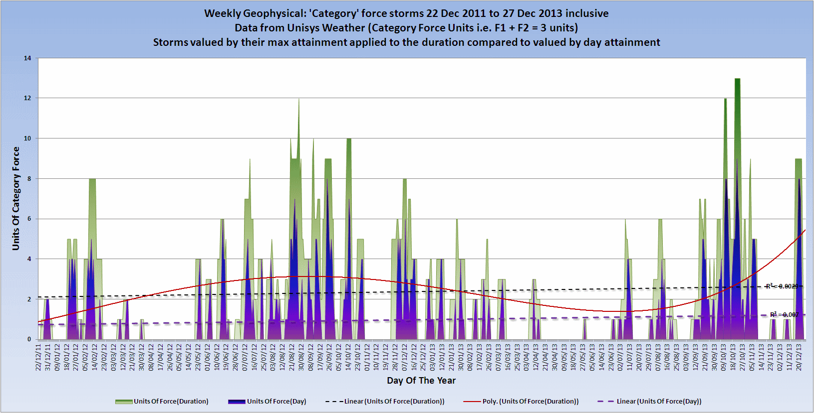
Whilst not quite as quiet on the Category force storms front the latest two larger storms were both at sea. The trend seems to be for a bunching, but overall compared to other years before 2011 there is a decrease. I don't have the charts for that yet but I am working on them.

Click the image to enlarge
The purple is the days where the storm was actually at category force as opposed to the green which is the duration of the storm at the maximum category force attained - an important distinction.
I can't as yet find a major drop in solar output that matches, but I am looking.It may take a while to isolate, but the December figures are not out for a few days yet so we shall see.
An update to my comment about any unusual trends.
We all are aware of the extraordinary drop in the level of earthquakes during December of last year - only 4 Mag 6+ which must be a record for a December - and you are probably also not aware that the number of converted mag 5 quakes (see my geophysical reports for an explanation) has bottomed and is at a lower level than 2002 and probably much earlier.
I am still working my way back through those.
What you are probably not aware of is that the volcanic eruptions have also gone to an unprecedented low. You may not believe that from media hype but I get alerts for all Google items with the word 'volcano' or 'eruption' - which is a ton of stuff every day - and I filter that for all current reports of volcanic activity of any kind.
Assuming San Miguel continues to Friday then here is the chart that will become this weeks extended volcano chart, and on it you can see that also during December volcanoes actually erupting using the criteria on the chart dropped.

Click the image to enlarge
Whilst not quite as quiet on the Category force storms front the latest two larger storms were both at sea. The trend seems to be for a bunching, but overall compared to other years before 2011 there is a decrease. I don't have the charts for that yet but I am working on them.

Click the image to enlarge
The purple is the days where the storm was actually at category force as opposed to the green which is the duration of the storm at the maximum category force attained - an important distinction.
I can't as yet find a major drop in solar output that matches, but I am looking.It may take a while to isolate, but the December figures are not out for a few days yet so we shall see.
reply to post by PuterMan
Interesting. Thx thx.
Do you suspect that things might be paradoxically 'building' to a 'quiet before the storm?'
Or just quieting down to an unusual but extended lower level of such parallel activities?
Interesting. Thx thx.
Do you suspect that things might be paradoxically 'building' to a 'quiet before the storm?'
Or just quieting down to an unusual but extended lower level of such parallel activities?
reply to post by PuterMan
Nice work as usual.
Just a note to consider. If you warm a rock, it takes time to build up heat. It also takes considerable time for the rock to cool down after you take the heat away.
There may be significant time lag, quite significant in fact, between solar output and effects that you are searching for. You probably already know this, just thought I would comment.
Thanks for all the work you do and the same goes to Muzzy.
P
First Felt report for 2014 for me. Just a minor one.
Was just a gentle rocking, no noise or shaking or rattling, only felt it because I was awake and laying there thinking "OMG I need to get up to go to work soon"
39 49 Felt reports, so I wasn't the only one awake at this ungodly hour
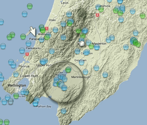
May have been predictable, there were a few micro quakes on the eastern shores of Lake Wairarapa on the 30th and 31st Dec 2013, a bit out of the ordinary. Dec2013 NZ
finger is the quake, arrow is where I'm at, circle is the "foreshocks"

Was just a gentle rocking, no noise or shaking or rattling, only felt it because I was awake and laying there thinking "OMG I need to get up to go to work soon"
Public ID 2014p001738
Universal Time January 1 2014 at 15:26:22
NZ Daylight Time Thursday, January 2 2014 at 4:26:22 am
Latitude, Longitude -40.94, 175.41
Intensity ? weak
Focal Depth 67 km
Magnitude 3.8
Location 20 km west of Masterton (Waiohine River, east side of Tararua Mts) (Wellington Fault)
Agency WEL(GNS_Primary)
Status ? automatic
Quality ? good
www.geonet.org.nz...
edit on 01u0014 by muzzy because: add link and update felt report number
May have been predictable, there were a few micro quakes on the eastern shores of Lake Wairarapa on the 30th and 31st Dec 2013, a bit out of the ordinary. Dec2013 NZ
finger is the quake, arrow is where I'm at, circle is the "foreshocks"

edit on 01u0014 by muzzy because: (no reason given)
Looks like Puterman was right on the money! Region-wise, this is pretty close to the his prediction anyway.
earthquake.usgs.gov...
M6.6 - 39km W of Sola, Vanuatu 2014-01-01 16:03:31 UTC
Location
13.868°S 167.183°E depth=196.0km (121.8mi)
earthquake.usgs.gov...
edit on 1/1/2014 by Nyiah because: (no reason given)
You nailed it Puterman. Vanuatu Mag 6.6 (USGS)
It's relatively deep, at 196 kms. Is there more to come?
EMSC Mag 6.6 These are preliminary and will probably be revised (USGS probably more than once, lol).
It's relatively deep, at 196 kms. Is there more to come?
EMSC Mag 6.6 These are preliminary and will probably be revised (USGS probably more than once, lol).
I wish all my fellow Quakers a happy new year!!
Keep up the good work!
Keep up the good work!
Happy New Year everyone!
Video: Slow quakes in the Nankai Trough
(I am still watching it, it's very interesting!
Stay safe and aware
Video: Slow quakes in the Nankai Trough
(I am still watching it, it's very interesting!
Stay safe and aware
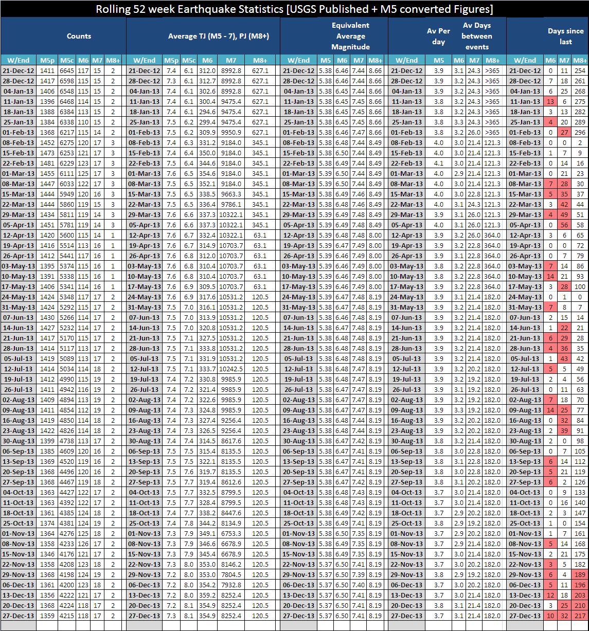
Geophysical report for 27th December now available. Effectively either this one or the next one could be considered as an 'annual report' for
2013.

Click the image to enlarge
Mag 7 and Mag 8 now both getting well past their sell by date. Looking at South America for the next I think.
Note how the Mag 5 converted curve has flattened. Once this starts rising the next Major or Great earthquake is on the way as far as I can tell from the short data I have so far.
new topics
-
More Bad News for Labour and Rachel Reeves Stole Christmas from Working Families
Regional Politics: 5 hours ago -
Light from Space Might Be Travelling Instantaneously
Space Exploration: 7 hours ago -
The MSM has the United Healthcare assassin all wrong.
General Conspiracies: 8 hours ago -
2025 Bingo Card
The Gray Area: 8 hours ago -
The Mystery Drones and Government Lies
Political Conspiracies: 9 hours ago
top topics
-
Pelosi injured in Luxembourg
Other Current Events: 16 hours ago, 21 flags -
The Mystery Drones and Government Lies
Political Conspiracies: 9 hours ago, 12 flags -
2025 Bingo Card
The Gray Area: 8 hours ago, 7 flags -
The MSM has the United Healthcare assassin all wrong.
General Conspiracies: 8 hours ago, 7 flags -
Light from Space Might Be Travelling Instantaneously
Space Exploration: 7 hours ago, 7 flags -
More Bad News for Labour and Rachel Reeves Stole Christmas from Working Families
Regional Politics: 5 hours ago, 7 flags
active topics
-
The Mystery Drones and Government Lies
Political Conspiracies • 61 • : sendhelp -
Drones everywhere in New Jersey
Aliens and UFOs • 128 • : angelchemuel -
-@TH3WH17ERABB17- -Q- ---TIME TO SHOW THE WORLD--- -Part- --44--
Dissecting Disinformation • 3681 • : Thoughtful3 -
Something better
Dissecting Disinformation • 25 • : Astrocometus -
Light from Space Might Be Travelling Instantaneously
Space Exploration • 16 • : atsalex2 -
Pelosi injured in Luxembourg
Other Current Events • 31 • : xuenchen -
2025 Bingo Card
The Gray Area • 14 • : Oldcarpy2 -
DONALD J. TRUMP - TIME's Most Extraordinary Person of the Year 2024.
Mainstream News • 40 • : WeMustCare -
A priest who sexually assaulted a sleeping man on a train has been jailed for 16 months.
Social Issues and Civil Unrest • 29 • : Oldcarpy2 -
Airplane Crashed and Airplane Disabled Near Ohare Airport - Could be UFO Related.
Aliens and UFOs • 69 • : WeMustCare
