It looks like you're using an Ad Blocker.
Please white-list or disable AboveTopSecret.com in your ad-blocking tool.
Thank you.
Some features of ATS will be disabled while you continue to use an ad-blocker.

Nevada Test Site test track
page: 13
share:
Out near the Yucca Mountain Project, I noticed a test track has shown up on the 2011 imagery that was not there in 2007.
Google Earth here:
36°46'41.09"N 116°17'28.03"W
Or hopefully this link will work.
google maps link
Now we know the Nevada Test Site has these robot guards. Maybe this was a test track used in developing them. This is a somewhat lighthearted video KLAS did on them. [Note Predators have Hellfire missiles, not sidewinders.)
I wonder if the 'humans' these things 'freed up' were actually fired. Private security patrolling a radioactive waste dump site from a cherry picker
would not have cost 2 million for a long time, and there would be a few less unemployed people in this country.
I guess some programs get more federal grants and have to use it or lose it.
Fun to watch either way.
I guess some programs get more federal grants and have to use it or lose it.
Fun to watch either way.
edit on 21-11-2012 by Lonewulph because: (no reason given)
reply to post by Lonewulph
The first of anything costs stupid money because all the design and tooling costs haven't been amortized. The very first model off the assembly line of a new Kia probably costs a few million. ;-)
Area 5 isn't all that dangerous. It is part of the NTS tour. But you wouldn't want somebody messing with the nuclear waste that is waiting to be sorted. That stuff just sits in a shed. The waste is eventually buried.
The time frame for the robots and the test track sounds about right. They were online in 2010. Figure on the NTS testing going for a year, so maybe the track would be done in 2009. The track was built between 2007 and 2011.
There was a thread on these 'bots on ATS at the time. If you look carefully at the design, they have large buttons on the outside that are the type you find on industrial machinery used to stop the dangerous machine. If they really are off buttons, then the robot isn't quite a good as the security guard.
The test track was built for testing the spent fuel transport caskets
oxoxoxooxx
oxoxoxooxx
www.motherjones.com...reply to
post by ANNED
This link is for an article on the Office of Secure Transportation. I bet they have a test track, but the track I pointed out is too small for a truck. The H on the cement pad is for a chopper, so if you are on google maps where you can't measure, you can see the test track is more suited for quads.
www.8newsnow.com...
This link is for the Needles UFO. I'm of the kinetic weapon (rods from God) school of thought on that one. If you are not familiar with the concept, a space based kinetic weapon is a rod of something tough, probably tungsten, that hits its target by falling out of the sky, with a bit of simple guidance. The rods sit in space until needed. Since energy is conserved, the kinetic energy of the rod falling from space is converted to nothing very pleasant.
It is really hard to crash a plane or spacecraft and then haul it away. Most crashes look like the object went through the shredder. You just don't pick up it up with a sky crane. Now kinetics weapons are designed to not break up upon impact because you want the maximum thunk.
The idea is old and the arguments go on for years if they actually exist. Because a space based kinetic weapon isn't anything more than mass and some guidance system, it really don't fall into a weapons treaty, such as a nuke in space would.
Nice spotting, gariac. It sure does appear to be a test track for something.
My NTS data shows that section as containing a "Sample Management Facility", "Hydrological Research Facility" and "Field Operations Center".
"Area 5" as mentioned in the video is a Radioactive Waste Management Site (RWMS) located here:
36°51'29.63"N, 115°57'19.91"W
Slightly OT, but for anyone interested I compiled a KMZ file for Google Earth, listing the different areas and facilities at the Nevada Test Site:
www.topsecretbases.com...
Also of interest is this listing of all the nuclear tests done there, showing location, date and yield:
www.topsecretbases.com...
reply to post by FosterVS
Those KMZs look good. I gather you looked up the nuke explosion sites rather than copied the Google Earth Community markings, many of which are wrong.
I was searching
dsearch.dtic.mil...
a few days ago and came across a report to establish a GWEN (Ground Wave Emergency Network] tower on the NTS. One of the study sites was near that racetrack. Otherwise, it isn't a particularly interesting part of the range, perhaps an advantage for the test development. [The GWEN is no longer operational.]
The GWEN tower ended up going to Austin Nevada. The GWEN wiki has the wrong location (surprise!). You can see where it used to be at
n39 23.46 w117 18.54
What you see there now is a USGS differential GPS beacon. But the ring on the ground might be left over from the GWEN site.
I don't have a photo handy, but my recollection is this location
36°36'10.37"N 115°59'59.13"W
is where they hold the trespassers when they protest to shut down the NTS. There are "his" and "hers" facilities, hence two fenced areas.
You know about my overlay, but for others reading this post:
www.lazygranch.com...
This is a scan of the map they would give away for the YMP tours.
This is a collection of communications sites on the range and surrounding areas:
www.lazygranch.com...
Most locations are from FCC filings.
This is the viewshed of Tikaboo Peak.
www.lazygranch.com/google_earth/tikaboo/tik.kmz
Originally posted by gariac
reply to post by FosterVS
Those KMZs look good. I gather you looked up the nuke explosion sites rather than copied the Google Earth Community markings, many of which are wrong.
I didn't create the nuke test KMZ, I found it somewhere on the web. I find it extremely interesting, the number and location of some of the tests. It is also EXTREMELY helpful when trolling around, looking at features of the NTS with Google Earth, weird ground features turn out to the site of an old test, or monitoring equipment etc.
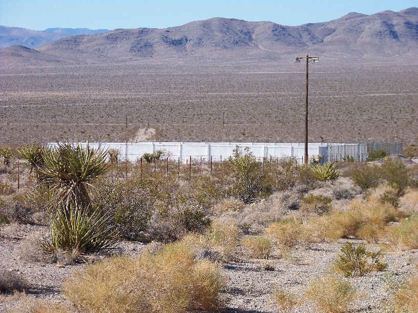
I don't have a photo handy, but my recollection is this location
36°36'10.37"N 115°59'59.13"W
is where they hold the trespassers when they protest to shut down the NTS. There are "his" and "hers" facilities, hence two fenced areas.
Pic I took in 2009. You gotta love the white plastic strips in the chain link fence, facing the highway, to block any view of prisoners that might be in there. I doubt it has been used much recently, the days of nuke protests is long over I think.
You know about my overlay, but for others reading this post:
www.lazygranch.com...
This is a scan of the map they would give away for the YMP tours.
Indeed I do, thank you, I have it printed out as a poster and hanging on my office wall
A fair bit of that NTS.KMZ file came from that.
edit on 24-11-2012 by FosterVS because: (no reason given)
reply to post by FosterVS
US atomic tests
This is the book of all nuclear explosions. I'd have to double check if it includes Trinity. They used to give the book away when the "reading room" was in the middle of nowhere. [Now it is in Las Vegas at the Atomic Testing Museum.] When you get to the bomb coordinates, you need to visualize a book laying flat where you see both pages. Otherwise it reads kind of funny.
Many of the bomb locations in the past were so far off that it was obviously wrong. One of the tests was in Pahrump! I don't think so!
NTS library
If you dig up the earthquake records on the day of the test, sometimes the explosion is recorded as a quake. Many of the earthquake logged events have made their way to google earth. Turn on just the "earthquakes" in the gallery and you can see them near the craters. Obviously some quakes were quakes. Little Skull Mountain for example.
new topics
-
Kamala Set A New Record
2024 Elections: 6 hours ago
top topics
-
Influx Of Migrants Just Doubled The Population Of A Small Ohio Town
Social Issues and Civil Unrest: 14 hours ago, 10 flags -
A new phase of evil brewing
General Conspiracies: 13 hours ago, 7 flags -
Of all things, grunge music. Short, simple, relevant, not NSFW.
Conspiracies in Religions: 12 hours ago, 5 flags -
Kamala Set A New Record
2024 Elections: 6 hours ago, 5 flags
active topics
-
BREAKING Israeli military says possibility' it has killed Hamas leader Yahya Sinwar
War On Terrorism • 65 • : jofafot -
Of all things, grunge music. Short, simple, relevant, not NSFW.
Conspiracies in Religions • 21 • : Solvedit -
Nearly one-third of Border Patrol’s cameras along the US-Mexico border ‘don’t work’
Social Issues and Civil Unrest • 6 • : Scratchpost -
Uk Govt sending staff and recruiting for people to campaign for Harris in the US
2024 Elections • 124 • : Oldcarpy2 -
Kamala Set A New Record
2024 Elections • 11 • : andy06shake -
25 illegal immigrants, 3 Disney employees 157 suspects arrested in human trafficking ring
Social Issues and Civil Unrest • 16 • : network dude -
Exhausted Donald has a Mic Malfunction
2024 Elections • 61 • : yeahright -
Euclid’s 208-Gigapixel glimpse into the Universe - Space is Big.
Space Exploration • 19 • : gortex -
The UN’s DARK Agenda: Agenda 2030
New World Order • 12 • : gortex -
We Now Know the Size of the Modern Gaming Audience - Sweet Baby Cries
Video Games • 7 • : gortex
3