It looks like you're using an Ad Blocker.
Please white-list or disable AboveTopSecret.com in your ad-blocking tool.
Thank you.
Some features of ATS will be disabled while you continue to use an ad-blocker.

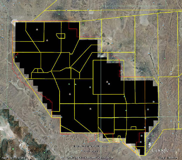
Most of NTTR Blacked Out in GE for 9/11/2010
page: 13
share:
I just noticed this tonite. In the past, many times, I have opened the History Slider in GE, and compared various spots at Area 51 and other places,
to compare changes.
Tonite I notice as I slide the date back to 9/11/2010, the entire NTTR is blacked out.
I KNOW in the past it hasn't been blacked out, so what gives? Did they realized something was exposed that shouldn't be, and force GE to black the entire site out?
Can someone else try this and confirm it?
Tonite I notice as I slide the date back to 9/11/2010, the entire NTTR is blacked out.
I KNOW in the past it hasn't been blacked out, so what gives? Did they realized something was exposed that shouldn't be, and force GE to black the entire site out?
Can someone else try this and confirm it?
I'm not sure what caused that. I happened to have GE open to check distance on the hurricane for another thread and checked. I'm zooming right into
the runways at Groom Lake and the facility near Yucca Mountain with no problems?
Originally posted by Wrabbit2000
I'm not sure what caused that. I happened to have GE open to check distance on the hurricane for another thread and checked. I'm zooming right into the runways at Groom Lake and the facility near Yucca Mountain with no problems?
The newest image (8/22/2011) displays no problem. But if you click open the history slider, and click the left arrow to where it says 9/11/2010 it only shows black for the whole NTTR (Nevada Test and Training Range). The image date at the bottom shows 8/30/2010. I also just noticed that sections are blacked out at 3/13/2011, 4/4/2011, etc. Not the entire NTTR, just parts.
Very strange. I wonder if this is just an anomaly, or perhaps the historic imagery is "offline" for some reason?
edit on 26-8-2012 by FosterVS because: (no reason given)
I had discovered this "black hole" and posted it to the blacktriangles yahoogroup on 4/22/2012. I'm not sure why I didn't post it to ATS, but I
often post the same data on several forums.
But I reported 8/30/2010 for the imagery date. The date on the history window doesn't seem to match the date at the bottom of the page. I think the date shown changes with the size of the area that you are viewing.
I am certain there was never imagery uploaded on the date indicated because I routinely check for updates to the TTR, which is where I first noticed this crop up. Technically, I check for updates and "down-dates" since Google Earth is known to upload old imagery completely out of the blue. Also they sometimes screw up and the new data is shown when you look for history.
The USDA sells imagery, something I hadn't realized at the time. I'd have to research it all again, but to my recollection the resolution isn't very good. Or at least they don't sell the general public the good stuff. As you know, the suckers er I mean readers at Dreamlandresort buy Groom Lake imagery every other year. It shows up on google earth a few months later after they spend the money. Not that I want to discourage anyone from contributing to the fund.
When that new water tower showed up on my last panorama, sure enough the foundation work was there on the last Google Earth. Sadly, nobody has got off their arses and done a panorama this year. I brought the gear when I went to watch Red Flag 2012-4, but the winds kicked up and put an amazing amount of dust in the air. It was so bad I didn't even bother to do a panorama at the TTR, which involves virtually no hiking. The last time I went to do a panorama at the TTR, a pack of wild horses decided to occupy Brainwash Butte. I'm game for adventure, but not that much adventure.
If only there was a "researcher" that lived around the range like Chuck Clark. Back in the Freedom Ridge days, you could get decent imagery with just a telephoto lens and a barlow.
From reading the Keyhole forum (Keyhole was the company that Google bought to create Google Earth), Google determines when to order imagery based on crowd sourcing where people look. So the more people looking around the NTTR, the more often it will in theory get updated. Groom Lake is an obvious place that gets viewed often. Not so much for the TTR or the rest of the range. One issue with the TTR is it is possible to identify the foreign radar at Site 4 (Have Glib). The same goes for Tolicha Peak ECR. So maybe the USAF asks Google to delay updates. Remember, Google is a very compromised company when it comes to dealing with the US government since Google has government contracts. That is why it is important that people go out there and photograph these sites so that we can be sure there is no censorship.
reply to post by FosterVS
I think if something were exposed, Google would just blur the area or simply remove the data but not black it out. I suspect the blacked out area is like a place holder. That is, imagery may go in there some day.
If you followed the thread I did on the blacked out area at Edwards, it was not a secretive area at all. So some blacked out areas could be glitches.
Originally posted by gariac
reply to post by FosterVS
I think if something were exposed, Google would just blur the area or simply remove the data but not black it out. I suspect the blacked out area is like a place holder. That is, imagery may go in there some day.
If you followed the thread I did on the blacked out area at Edwards, it was not a secretive area at all. So some blacked out areas could be glitches.
Maybe it's just me then. But I am sure I have picked certain spots, and used the history slider to view changes over time. Including facilities right at Area 51. And I do not recall it being blacked out.
It is strange that the blacked out "place holder" is almost exactly the size and shape of the NTTR.
reply to post by FosterVS
I agree the blacked out deal is new. I do think that someday they will put the USDA imagery there.
Finding someone with "authority" at Google is damn tough. This is a company that spends nothing on customer service personnel. [You may laugh at yahoo, but at least I was able to talk to a live person there.] At best, you might find a google employee that knows what's up posting on one of their developer forums. So I think getting a definitive answer on these black spots is not going to happen.
Now here is my problem with the black spot. It does seem to follow the NTTR outline. But new data shows up in stripes. It would be odd for the new data to show up with exactly the outline of the NTTR.
If you look at the blacked out area I posted versus what is blacked out today, the blacked out regions to the east of Groom Lake are no longer
blacked out. That may further the theory that the blacked out regions are place holders for new imagery.
Originally posted by gariac
If you look at the blacked out area I posted versus what is blacked out today, the blacked out regions to the east of Groom Lake are no longer blacked out. That may further the theory that the blacked out regions are place holders for new imagery.
I am still confused. According to the GE Help, "The small vertical lines on the timeline indicate the dates of different imagery available for your location."
There is a vertical line for 9/11/2010, which has Area 51 blacked out. I am zoomed in, trying to see construction progress of a building that is just SE of the helicopter pads. 8/22/2011 shows contruction in progress. The next vertical line is for 6/28/2010.
Maybe I am confused, but were there no Area 51 image updates from 6/28/2010 to the current 8/22/2011 image?
I understand sort of how it works, a vertical line will appear for any historic images for the area you have visible in the GE window. i.e. the more I zoom out from about 1000 ft. to say 35 miles, far more vertical lines show up as there are more possible historic images within view, if that makes sense.
We're probably doing well if we get yearly imagery for Groom Lake.
I googled around looking for information on the black spots and all I found were posts from asshats with conspiracy theories.
If anyone is on google plus, this is a link to someone who works at Google within Google Earth.
plus.google.com...
I couldn't find an email address for him. I guess google values the privacy of their employees, but of course not your privacy. ;-)
Go to
37.875628° -116.821395°
on Google Earth. That is the the XSD NDB (non-directional beacon). This particular spot is where old and new imagery meets, so it looks like it has a line going through it.
If you click the history button once, it shows the whole area at the 8/30/2010 imagery date. [Odd line now gone.] The next click takes you back to 6/27/2003. In that image, you see two telephone poles. With better resolution, you would see wire from pole to pole. The point of this exercise is to show that the NDB gas been removed. Not a big shocker since it hasn't been operational for a few years. The AEC NDB at Base Camp has been gone for a while (maybe 2009 or 2010).
I suspect (but have no proof) that these NDBs were kept running for training purposes. That is, the TTR and Base Camp have VORTACs, so the NDBs are not needed. But perhaps crews would train using NDBs for landing at bases that lacked VOR or VORTACs.
It's aliens there! They didn't want to expose them! ....
Of course it's blacked out for 2 reasons:
- your internet sucks and didn't load the images
- this is a military base, do they have to show you everything god damnit!?!?!?
Such way of thinking makes me ..
Of course it's blacked out for 2 reasons:
- your internet sucks and didn't load the images
- this is a military base, do they have to show you everything god damnit!?!?!?
Such way of thinking makes me ..
I upgraded to Google Earth 7 and noticed this black region is gone. At first I thought it might be due to the cache being cleared, so I viewed the
same area using Google Earth 6 on another PC and the black region is also gone. This is basically a "ping" to request others to verify this.
On Google Earth 7, when I went back in time, the old imagery was blurry. Hacking a bit, it seems this is only true if I am in OpenGL. On OpenGL, the current imagery looks sharp on GE7. It is just the history that looks blurry.
I have no idea why GE picked open GL as a default since I wasn't on linux or a Mac. [DirectX is the way to go if you are on a PC.] Switching back to DirectX, the blurry history problem went away.
In regards to blurring images on GE in National Security matters; to add some backing to gariac's previous mentions. Bill Sweetman did a write up in
2011 about similar findings in his hunt for the stealth choppers involved with the Osama raid on the AV Week site...
You can read the full write up at the link below. It's worth the read.
Click Here To Read More
According to Google, the NY State office “did some processing (apparently blurring of a sophisticated nature using truncated wavelet transformations) of areas that might be generally described as ‘being on the National Critical Infrastructure Protection List.’,” maintained by the Department of Homeland Security. The effects can be seen here in a close view of the airport boundary.
You can read the full write up at the link below. It's worth the read.
Click Here To Read More
The coordinates for that airport are
42° 9'40.95"N 76°53'46.26"W
All you have to do is click the history button and it comes in without the blur. One thing to note about Google Earth is sometimes they don't show the most recent image as the default. So clicking on the history button without going back in time can get you a different image. Also, there is some blending of images at the transition region between imagery sets, often obscuring useful imagery.
Lastly, occasionally Google Earth adds old imagery to the history feature. Now in most cases, this would be pretty hard for someone to notice. But they added imagery at the new hangar at Groom Lake that included a Beechcraft, which is how I knew something was added since I wouldn't have missed an aircraft near the hangar.
Regarding acoustic stealth
www.capfalcon.net...
Tail rotors get really hot. I'm not sure why they get hotter than any other rotating prop, but I've watched blacked out choppers in the desert with gen 2 NV and the tail rotor hub just glows.
I have a photo of a Lord NVX they junked at the El Mirage.
www.lazygranch.com...
The Indian government uses Lord gear to reduce vibration in their ultra high altitude choppers they use to defend that worthless uninhabitable mountainous region they "share" with Pakistan. I don't know if the active vibration reduces the external noise.
new topics
-
Kamala Set A New Record
2024 Elections: 6 hours ago
top topics
-
Influx Of Migrants Just Doubled The Population Of A Small Ohio Town
Social Issues and Civil Unrest: 14 hours ago, 10 flags -
A new phase of evil brewing
General Conspiracies: 13 hours ago, 7 flags -
Of all things, grunge music. Short, simple, relevant, not NSFW.
Conspiracies in Religions: 12 hours ago, 5 flags -
Kamala Set A New Record
2024 Elections: 6 hours ago, 5 flags
active topics
-
BREAKING Israeli military says possibility' it has killed Hamas leader Yahya Sinwar
War On Terrorism • 65 • : jofafot -
Of all things, grunge music. Short, simple, relevant, not NSFW.
Conspiracies in Religions • 21 • : Solvedit -
Nearly one-third of Border Patrol’s cameras along the US-Mexico border ‘don’t work’
Social Issues and Civil Unrest • 6 • : Scratchpost -
Uk Govt sending staff and recruiting for people to campaign for Harris in the US
2024 Elections • 124 • : Oldcarpy2 -
Kamala Set A New Record
2024 Elections • 11 • : andy06shake -
25 illegal immigrants, 3 Disney employees 157 suspects arrested in human trafficking ring
Social Issues and Civil Unrest • 16 • : network dude -
Exhausted Donald has a Mic Malfunction
2024 Elections • 61 • : yeahright -
Euclid’s 208-Gigapixel glimpse into the Universe - Space is Big.
Space Exploration • 19 • : gortex -
The UN’s DARK Agenda: Agenda 2030
New World Order • 12 • : gortex -
We Now Know the Size of the Modern Gaming Audience - Sweet Baby Cries
Video Games • 7 • : gortex
3