It looks like you're using an Ad Blocker.
Please white-list or disable AboveTopSecret.com in your ad-blocking tool.
Thank you.
Some features of ATS will be disabled while you continue to use an ad-blocker.
0
share:
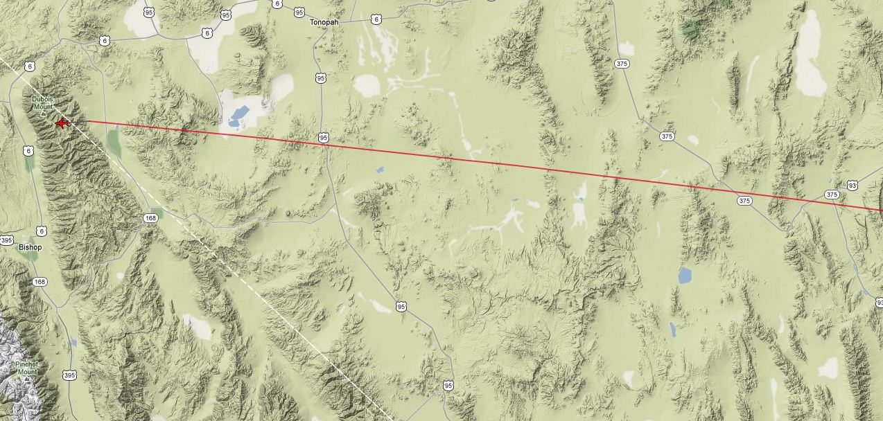
Take a look here at two United flights being really close to Groom Lake area.
I thought this was a very restricted area which would be R-4808N.
This was taken from Planefinder.net
Is this normal especially if Nellis are NOT conducting Red Flags??
I thought this was a very restricted area which would be R-4808N.
This was taken from Planefinder.net
Is this normal especially if Nellis are NOT conducting Red Flags??
edit on 13-7Jul-122012 by darpa999 because: (no reason given)
Even with no flags running, commercial aircraft would not be flying that close to Groom Lake. What is happening is there are thunderstorms around
Vegas. The last time I check they were west of the city. Ely is really getting zapped. By some fluke, the NTTR is relatively lightning free. Thus ATC
instructed the commercial flights to go over the range. It is Nellis Control in charge, so it is not like the DoD doesn't know what is going on.
I posted one of these reroutings a few years ago.
I posted one of these reroutings a few years ago.
www.abovetopsecret.com...
This is my old post. Don't get me wrong concerning my interest level. Any time some commercial plane flies over the range, I would like to hear about it.
This is the live lightning viewer for the Nellis range;
www.sord.nv.doe.gov...
This is my old post. Don't get me wrong concerning my interest level. Any time some commercial plane flies over the range, I would like to hear about it.
This is the live lightning viewer for the Nellis range;
www.sord.nv.doe.gov...
Here is the NOTAM for the current Red Flag. "L" indicates local time. "Z" for zulu. Note Nellis gets the times wrong often. ;-) Due to the
location of the international dateline, even the days are often posted incorrectly.
Data Current as of: Sat, 14 Jul 2012 01:58:00 UTC
LSV NELLIS AFB M0254/12 -
LARGE FORCE EXERCISE IN PROGRESS. NO TRANSIENT ACFT ARRIVAL OR DEPARTURES DURING LAUNCH AND RECOVERY TIMES.
MASS LAUNCH AND RECOVERY TIMES ARE:
16-17 JULY 1500-1600L (2200-2300Z),
1700-1830L(0000-0130Z),
AND
2130-2230L(0430-0530Z).
13 JUL 22:40 2012 UNTIL 17 JUL 05:30 2012.
CREATED: 13 JUL 22:45 2012 TNX
TONOPAH TEST RANGE
M0108/12 -
MOVEMENT AREA VFR OPERATORS USE CAUTION FOR INCREASED VOLUME OF HIGH PERFORMANCE MILITARY FLIGHT OPERATIONS THROUGHOUT R4809A. 13 JUL 14:04 2012 UNTIL 20 JUL 23:59 2012. CREATED: 13 JUL 14:11 2012
For some reason your images were deleted. If they were on planefinder, most likely they are on flightaware if you know the flight ID or tail number.
Do you have that data available?
Interesting...I've never heard of a commercial plane flying directly over 4808. That would be pretty cool for the passengers. lol
new topics
-
'Mass Casualty event' - Attack at Christmas market in Germany
Mainstream News: 2 hours ago -
Search to Resume for MH 370
Disaster Conspiracies: 4 hours ago -
Sue Gray, Sir Keir Starmer's former Chief of Staff, Nominated for Peerage
Regional Politics: 6 hours ago -
Biden Nationalizes Another 50,000+ Student Loans as He Heads for the Exit
US Political Madness: 7 hours ago
top topics
-
'Mass Casualty event' - Attack at Christmas market in Germany
Mainstream News: 2 hours ago, 19 flags -
An Interesting Conversation with ChatGPT
Science & Technology: 16 hours ago, 8 flags -
Biden Nationalizes Another 50,000+ Student Loans as He Heads for the Exit
US Political Madness: 7 hours ago, 7 flags -
Search to Resume for MH 370
Disaster Conspiracies: 4 hours ago, 4 flags -
Sue Gray, Sir Keir Starmer's former Chief of Staff, Nominated for Peerage
Regional Politics: 6 hours ago, 3 flags
active topics
-
'Mass Casualty event' - Attack at Christmas market in Germany
Mainstream News • 33 • : AlroyFarms -
An Interesting Conversation with ChatGPT
Science & Technology • 22 • : hydr0cannibal -
Can someone 'splain me like I'm 5. Blockchain?
Science & Technology • 91 • : imitator -
Drone Shooting Arrest - Walmart Involved
Mainstream News • 37 • : BeyondKnowledge3 -
US Federal Funding set to Expire December 20th. Massive CR on the way.
Mainstream News • 50 • : Skinnerbot -
Squirrels becoming predators
Fragile Earth • 34 • : NorthOS -
Russias War Against Religion in Ukraine
World War Three • 54 • : andy06shake -
Search to Resume for MH 370
Disaster Conspiracies • 3 • : chr0naut -
-@TH3WH17ERABB17- -Q- ---TIME TO SHOW THE WORLD--- -Part- --44--
Dissecting Disinformation • 3768 • : Thoughtful3 -
Have you noticed?? Post Election news coverage...
World War Three • 10 • : chr0naut
0


