It looks like you're using an Ad Blocker.
Please white-list or disable AboveTopSecret.com in your ad-blocking tool.
Thank you.
Some features of ATS will be disabled while you continue to use an ad-blocker.

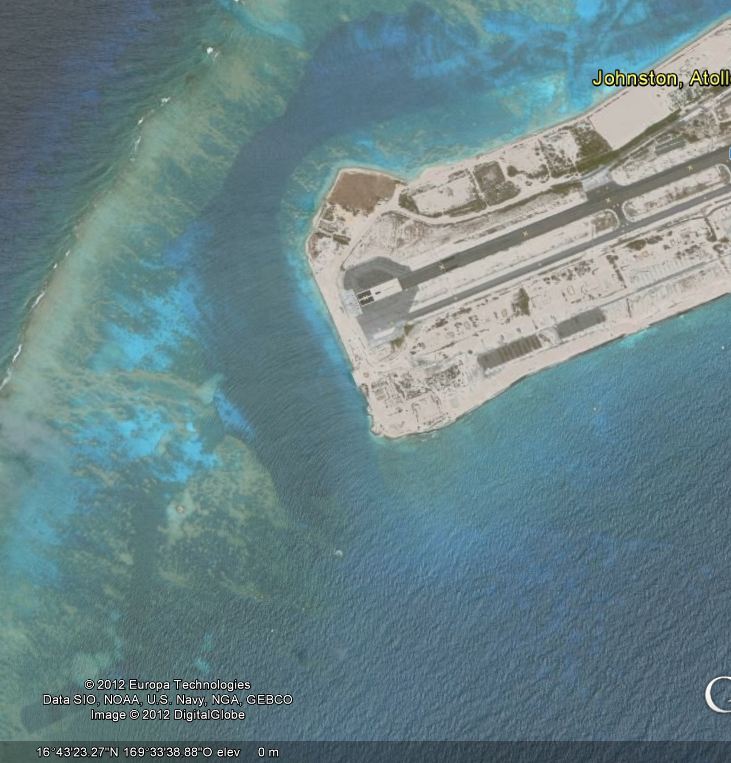
A Disk in the waters around the Mysterious Johnston Atoll, in the middle of Pacific Ocean.
page: 2share:
Originally posted by Imagewerx
Originally posted by smurfy
dredging coral, why would they do that? the atoll is obviously a dirty place and the military have pissed off, Arken may just have hit on something here, but what?
They dredged to increase the size of the islands......
familypedia.wikia.com...
It's now nothing more sinister than a nature reserve.
Chemical waste disposal area, nuclear detonations, makes you wonder at the nature of the nature there.
I have seen these near other islands in the Pacific-- also sometimes square and rectangular, and apparently out of concrete. There appears to be
another one, submerged, about half a klick slightly south of east of the one beginning your OP.
I just spent a few minutes trying to locate some examples, using the Solomon Islands which I thought was where I had run across many of these before-- but found nothing.
I never did find out their purpose, but contented myself with the likelihood that they were cast concrete structures to serve as piers, crane mast supports, foundations for temporary navigation aids, or some such mundane uses.
This just in...
Based upon this map, I would guess the structure(s) represents a foundation for seaplane landing navigation aids-- or radio navigation beacons.
edit on 21-1-2012 by Frira because: map, new
idea
Originally posted by Arken
I found this strange circular structure/object in the water of Johnston Atoll.
This particular picture is nothing more than a section of the atoll's own coral reef taken close up - see many other images of it in Google pictures
The other one I have no idea - TBH it is not much more than an ill-defined blob to me
edit on 21-1-2012 by Aloysius the Gaul because: (no
reason given)
Originally posted by smurfy
Originally posted by Imagewerx
Originally posted by smurfy
dredging coral, why would they do that? the atoll is obviously a dirty place and the military have pissed off, Arken may just have hit on something here, but what?
They dredged to increase the size of the islands......
familypedia.wikia.com...
It's now nothing more sinister than a nature reserve.
Chemical waste disposal area, nuclear detonations, makes you wonder at the nature of the nature there.
I spent 10 years in the Army Chemical Corp and I know this area used to be a chemical weapon storage site. It was a 12 month hardship tour that most chemical people got stuck having to go to. The job was usually monitoring stockpiles for leaking munitions. Can't say what the concrete disk is, but I also suspect it was a platform for a crane to offload supplies from ships.
reply to post by rjbaggins
Indeed - Johnston Atoll was mentioned in a lot of news reports in the 90's IIRC, as the site for incinerating chemical weapons - that certainly wasn't secret.
Edit to add: check out these pages of servicemens memories of JI - lots of photos - none of the mysterious disc that I can see tho - but be warned - if you go to the home page there's a corny song that plays!
edit on 21-1-2012 by
Aloysius the Gaul because: (no reason given)
Originally posted by youdidntseeme
Looking in google maps at some sat images of the atoll, there does appear to be some altering to the image.
In my post above stated that the 'man-made' images in the video were probably because they are manmade structures due to the dredging.
I still think they are, but this is what I found interesting
Do these images appear to have brushstrokes in them from photoshop or another imaging program?
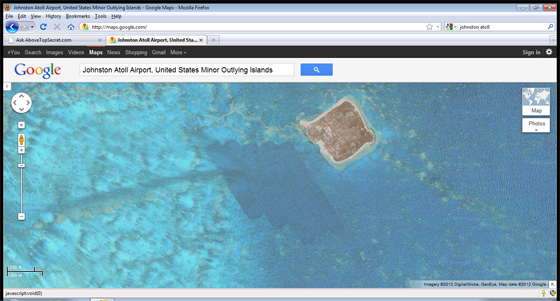
These trenches show on a depth-soundings map on the home page of the site in my previous message (watch out for the music!! ) - they seem to be just dredged channels in the coral.
Originally posted by Aloysius the Gaul
reply to post by rjbaggins
Indeed - Johnston Atoll was mentioned in a lot of news reports in the 90's IIRC, as the site for incinerating chemical weapons - that certainly wasn't secret.
Edit to add: check out these pages of servicemens memories of JI - lots of photos - none of the mysterious disc that I can see tho - but be warned - if you go to the home page there's a corny song that plays!edit on 21-1-2012 by Aloysius the Gaul because: (no reason given)
Thanks for posting that site. It was interesting reading about life on the atoll in the 50's. It's funny that even then the fella's wouldn't eat any of the fish. I guess those fish could have been feeeding on things that were contaminated during the earlier atomic tests that were done around there.
_________________________
A chemical dump, yet it was listed for sale
for residential family living ? ? ?
"The island can be used as a residence or vacation
getaway but it does not have utilities or a water supply."
That's the u.s.a government for you
www.johnstonmemories.com...
_________________________
A chemical dump, yet it was listed for sale
for residential family living ? ? ?
"The island can be used as a residence or vacation
getaway but it does not have utilities or a water supply."
That's the u.s.a government for you
www.johnstonmemories.com...
_________________________
edit on 22/1/12 by ToneDeaf because: (no reason given)
Good post. I never knew this atoll existed and plan on reading up on it.
That said, I was struggling to see anomalies on the YouTube video and some of the pictures. Once I study up on the Atoll and understand it better, I will come back and look at the info again.
That said, I was struggling to see anomalies on the YouTube video and some of the pictures. Once I study up on the Atoll and understand it better, I will come back and look at the info again.
reply to post by Sharpenmycleats
That's because there aren't any anomalies,they only get seen as such because some people actually want them to be there.It's a remote airstrip used because of it's remoteness to store/dump/dispose of chemical weapons,amongst them was this lovely stuff.......
en.wikipedia.org...
And this even nicer stuff.....
en.wikipedia.org...
The underwater disk has just about visible square corners if you zoom right in,so will be nothing more suspicious than the base for maybe a navigation aid or shallow water warning as used close to shore elsewhere in the world.
edit on 22-1-2012 by Imagewerx because: (no reason given)
Originally posted by deadeyedick
Maybe it's a drain plug.
If someone wants to pay for me to charter a plane or boat to get me there,I'll quite happily get my diving gear on to swim down to it and give it a good hard tug to see what happens.
Thanx for posting OP.
Just booking my seat, will be back to post later.
Posted Via ATS Mobile: m.abovetopsecret.com
Just booking my seat, will be back to post later.
Originally posted by Aloysius the Gaul
These trenches show on a depth-soundings map on the home page of the site in my previous message (watch out for the music!! ) - they seem to be just dredged channels in the coral.
My thoughts as well, i just found it interesting that the marks looked exactly like brushstrokes to me.
I usually just ignore findings like that and boil it down to the most common denominator, ie dredge marks...but in this case I had to share.
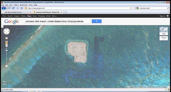
I'd say that the blue band around the island is due to dredging. They did make the island by dredging. Wouldn't it make sense to dredge nearby?
Plus, the dredged area makes it navigable to large ships all the way around the island.
As for the dome, it looks very similar to Cactus Dome. It may be where they put most of the contaminated dirt or they may have simply covered up a crater with concrete to prevent further contamination from escaping.
Cactus Dome

Funny how there are similar round structures at places where nuclear testing was done.
As for the dome, it looks very similar to Cactus Dome. It may be where they put most of the contaminated dirt or they may have simply covered up a crater with concrete to prevent further contamination from escaping.
Cactus Dome
Funny how there are similar round structures at places where nuclear testing was done.
For what it’s worth::
As others have stated, Johnston Atoll has been used for high altitude nuclear testing since the fifties and, as I understand it, they have had a couple of nuclear accidents there as well. When I flew through there in 1998 no one was allowed to exit the plane unless that was their destination. For it to be their destination one had to be employed by one of the government contractors there. In other words, no tourists are allowed. This page has a rather good article:
www.airfields-freeman.com...
Scroll down to or search for “Johnston Atoll Airport” in the above link.
As to the circular anomaly, I don’t have a clue, but as to the bluish square like areas around the islands, definitely due to dredging. This can be seen on other islands in the pacific like this one of Kwajalein:
maps.google.com...,+Marshall+Islands&hl=en&ll=8.734265,167.73119&spn=0.057264,0.063429&sll=19.973349,-179.208984&sspn=53.90 4384,58.447266&vp6&hnear=Kwajalein+Atoll&t=h&z=14
[EDIT]
It looks like the link above did not come out as well as I had hoped. The entire thing is:
//maps.google.com/maps?q=Kwajalein+Atoll+Marshall+Islands&hl=en&ll=8.734265,167.73119&spn=0.057264,0.063429&sll=19.973349,-179.208984&sspn=53.90%20438 4,58.447266&vp6&hnear=Kwajalein+Atoll&t=h&z=14
..Place "http:" before the "//" without the quotes.
[END EDIT]
Johnston Atoll was also a jumping off point for Kwajalein island in the Kwajalein Atoll (Marshall Islands) before there was jet service to that area (Kwaj did not have FAA jet certification until 1968), . This is a very important island for several reasons. During the war in the Pacific, Kwajalein was the first territory taken from the Japanese by the Americans. Kwajalein was also the staging point for the atomic bomb testing done at Bikini atoll (which is where the “Bikini” swimsuit got its name), and is about 300 miles north and west of Kwaj. Today the Kwajalein atoll is the far end of the Pacific missile test range (now known as the “Ronald Reagan Ballistic Missile Defense Test Site”), with the near end at Vandenberg AFB, in California. The lagoon which is surrounded by an atoll comprised of some 80 or so islands is the largest one in the world. A great book on that subject is “Operation Crossroads” · ISBN-10: 1557509190 · ISBN-13: 978-1557509192
Kwajalein and the northern island pair Roi-Namur also figures in one persons account of what happened to Amelia Earhardt. In fact the history of that whole area is quite interesting.
edit on 22-1-2012 by Dr. X because: Clearify Google link
Offshore platforms for artillery or anti-aircraft where common in WWII. These "Sea forts" where positioned to guard water approaches that land based
defenses could not cover.
The most logical explanation is this is a WWII structure no longer in use.
Google "Sea forts" to see similar examples.
The most logical explanation is this is a WWII structure no longer in use.
Google "Sea forts" to see similar examples.
edit on 26-1-2012 by IBelieveInMe because: (no reason given)
reply to post by IBelieveInMe
i worked at the atoll in 1992, the corral had to be dredged so that heavy ships could come close up to the atoll, there is one side which is the deepest and closest to the land, there is one small area that is the original atoll , with the sand and all still intact, i used to see dead sharks on the west side, the disk in question was not visible from the atoll, so it had to be underwater, way underwater I know because i would sit there and watch the waves
i worked at the atoll in 1992, the corral had to be dredged so that heavy ships could come close up to the atoll, there is one side which is the deepest and closest to the land, there is one small area that is the original atoll , with the sand and all still intact, i used to see dead sharks on the west side, the disk in question was not visible from the atoll, so it had to be underwater, way underwater I know because i would sit there and watch the waves
reply to post by storm1
Thanks for your post.
Something particular about Akau Atoll?
Thanks for your post.
Something particular about Akau Atoll?
edit on 12-12-2012 by Arken because: (no reason given)
new topics
-
Apophis Asteroid On Track To Potentially Impact Earth 2029
Space Exploration: 2 hours ago -
2024 Election - Americans Will Choose either 2018 Republicans -or- 2022 Democrats.
2024 Elections: 3 hours ago -
Trump announces he will eliminate ALL tax on overtime pay
2024 Elections: 7 hours ago -
Kamala & Biden get *SILENCE* from firefighters, Trump gets huge applause
Politicians & People: 9 hours ago
top topics
-
Trump announces he will eliminate ALL tax on overtime pay
2024 Elections: 7 hours ago, 18 flags -
Kamala & Biden get *SILENCE* from firefighters, Trump gets huge applause
Politicians & People: 9 hours ago, 13 flags -
A conservative weighs in on the Taylor Swift issue.
Politicians & People: 12 hours ago, 11 flags -
Jon Bon Jovi saves woman on Nashville bridge
People: 15 hours ago, 10 flags -
Undecided Voters Say TRUMP WON Debate, Kamala Came Off As SNOOTY
2024 Elections: 15 hours ago, 10 flags -
Biden Dons Trump Hat
Jokes, Puns, & Pranks: 16 hours ago, 5 flags -
Apophis Asteroid On Track To Potentially Impact Earth 2029
Space Exploration: 2 hours ago, 1 flags -
2024 Election - Americans Will Choose either 2018 Republicans -or- 2022 Democrats.
2024 Elections: 3 hours ago, 0 flags
active topics
-
In Russia, a multi-thousand Russian march in honor of Alexander Nevsky took place
Above Politics • 150 • : andy06shake -
The UK collapsing fast
Science & Technology • 205 • : andy06shake -
The debate. Who wins?
2024 Elections • 927 • : andy06shake -
Russia Ukraine Update Thread - part 3
World War Three • 6562 • : F2d5thCavv2 -
Nano bots in the vaccine
Science & Technology • 125 • : andy06shake -
Future Russian Tzar 2022 Log
Dreams & Predictions • 268 • : GogolJoker -
POLLS - Leading Up To The November 2024 USA Elections.
2024 Elections • 307 • : liberalskeptic -
Psychedelic Mushrooms May Have Contributed To Early Development Of Human Consciousness
Origins and Creationism • 24 • : SecretKnowledge2 -
Evidence President BIDEN Ordered The Assassination of Candidate Donald TRUMP on July 13th 2024.
2024 Elections • 132 • : liberalskeptic -
Apophis Asteroid On Track To Potentially Impact Earth 2029
Space Exploration • 0 • : Skywatcher2011