It looks like you're using an Ad Blocker.
Please white-list or disable AboveTopSecret.com in your ad-blocking tool.
Thank you.
Some features of ATS will be disabled while you continue to use an ad-blocker.
1
share:
I came across a video on youtube that show a weird anomali on the moon. Im not sure if the map is fake or not, but to me it looks like a glass-tube
that lead into a mountain on the moon. Is it like the tubes on Mars?
here is another structure or anomaly on the moon.
Im not sure about this video, to me it looks like two maps that has been joined.
Theres also the pyramid on the moon which has been addressed in other threads on ATS, here is a video of it taken by Hubble.
Could this be linked to Neil Armstrongs "infamous" message about the lectures to those who remove the curtain that cover the truth?
edit on 8-10-2011 by Mimir because: (no reason given)
looks like a error in the topography of the map... see the tearing artifacts on either side of the ends of the tube? (perfectly straight vertical
lines on either side) I think its from badly aligning multiple pictures.
reply to post by Slanter
Thats a possebility, in 2nd video there's a obvious failed alignment.
Thats a possebility, in 2nd video there's a obvious failed alignment.
edit on 8-10-2011 by Mimir because: (no reason given)
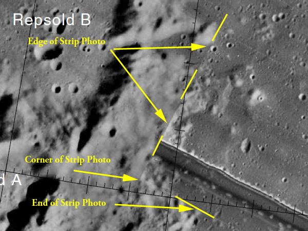
I have to work in the morning so this was quick, but these photos are composites of satellite strip photos. I marked up the picture from the first
video below. The page he used is USGS/NASA if you want to see them
yourselves. There are full color ones also.USGS/NASA Site Homepage


edit on 8/10/11 by spirit_horse because: replaced pic easier to see strip
Yes when you put a round 3D surface image onto a flat 2D camera image, it doesn't fit. The said they eliminated a lot of the errors but not all:
Originally posted by Mimir
reply to post by Slanter
Thats a possebility, in 2nd video there's a obvious failed alignment.edit on 8-10-2011 by Mimir because: (no reason given)
planetarynames.wr.usgs.gov...
The feature isn't too far from the edge of the image, and it abruptly ends at the ends of the image. A real feature would be unlikely to end exactly where the image ends. It's not impossible, but it's more than a coincidence if it does that at BOTH ends, the odds of that probably ARE close to impossible.
Note that some distortion of the shaded relief base was introduced when it was warped to the CLCN; this distortion is pronounced in some areas at 1:1 million-scale. The CLCN (and therefore the Clementine mosaic and related products, including the base images used for these maps) was later found to have large horizontal errors, on average of about 7 km, and in some areas perhaps as great as 20 km. Those errors have been largely corrected with the Unified Lunar Control Network (ULCN) 2005 (Archinal et al., 2006), on which the Lunar Orbiter global mosaic is based (Becker et al., 2005, 2008).
Note that because the two sets of maps use different control, the locations of the features are slightly shifted, and features near or on the edges of maps might fall within different quadrangles.
So my best guess is, it's an artifact of the process of making the mosaic. They said the errors have been "largely" corrected, which implies there are some left that weren't corrected, and if they were 7-20km, that's significant.
It occurs at a scanning sequence, and is in parallel with all the other scanning lines, so it's most likely a scanning glitch. all that stuff in
explained properly here,
www.lpi.usra.edu...
www.lpi.usra.edu...
www.lpi.usra.edu...
www.lpi.usra.edu...
new topics
-
The Popular Vote does not matter
US Political Madness: 12 minutes ago -
Gaetz withdraws from attorney general consideration
US Political Madness: 3 hours ago -
Bridgewater Triangle
General Chit Chat: 3 hours ago -
Is Russia Using a New Type of Beam Weapon Against Ukraine?
Weaponry: 4 hours ago -
Here is why Western leaders in NATO have zero fear of nuclear warfare. At all. Zero.
World War Three: 6 hours ago -
International Criminal Court Issues Arrest Warrant For Netanyahu
Breaking Alternative News: 6 hours ago -
racist rant, but she made the arguement to get rid of DEI
US Political Madness: 8 hours ago -
Well we know Putins ICBMs won't fail in their silos
World War Three: 8 hours ago
top topics
-
Well we know Putins ICBMs won't fail in their silos
World War Three: 8 hours ago, 12 flags -
racist rant, but she made the arguement to get rid of DEI
US Political Madness: 8 hours ago, 9 flags -
International Criminal Court Issues Arrest Warrant For Netanyahu
Breaking Alternative News: 6 hours ago, 8 flags -
Is Russia Using a New Type of Beam Weapon Against Ukraine?
Weaponry: 4 hours ago, 8 flags -
Gaetz withdraws from attorney general consideration
US Political Madness: 3 hours ago, 5 flags -
Here is why Western leaders in NATO have zero fear of nuclear warfare. At all. Zero.
World War Three: 6 hours ago, 4 flags -
Why isn't Psychiatry involved?
Social Issues and Civil Unrest: 14 hours ago, 4 flags -
Bridgewater Triangle
General Chit Chat: 3 hours ago, 4 flags -
Help in song interpretation
Music: 16 hours ago, 3 flags -
The Popular Vote does not matter
US Political Madness: 12 minutes ago, 1 flags
1
