It looks like you're using an Ad Blocker.
Please white-list or disable AboveTopSecret.com in your ad-blocking tool.
Thank you.
Some features of ATS will be disabled while you continue to use an ad-blocker.
3
share:
In light of recent events currently unfolding and the increased number of earthquakes we've seen recently, I wanted to throw out the un-asked
question of, "What happens when the Central United States get the The Big One from the New Madrid Fault Line?"

www.scchealth.org
Why would the "Big One" come from the New Madrid fault line? It's long over due and if history is any indicator, this area will bare the brunt:
wikipedia
Just a side note here to remind everyone that this is the fault that caused the Mississippi River to flow backwards for a short time. That's a monster quake.
What really frightens me is that since I was just a wee tike, I've heard talk of a catastrophic event that could drop landmass into the ocean and raise the sea level. I don't hear much talk of such an event anymore, but I've always kept it in the back of my mind.
Flooding


I believe it would take more than a quake from the New Madrid Fault Line to raise the sea level to this elevation, but an event such as a large meteor impact could induce the rupture of several fault lines throughout the world, as well as creating a mega-tsunami that could cause flooding of this magnitude. Of course this would be worldwide and not simply an American concern.

www.scchealth.org
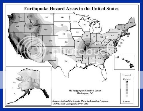
THE HIGHEST EARTHQUAKE RISK in the UNITED STATES outside the West Coast is along the New Madrid Fault. Damaging tremors are not as frequent as in California, but when they occur, the destruction covers over more than 20 times the area because of underlying geology.
A DAMAGING EARTHQUAKE in this AREA, 6.0 or greater, occur about every 80 years (the last one in 1895). The results would cause serious damage to schools and masonry buildings from Memphis to St Louis.
Why would the "Big One" come from the New Madrid fault line? It's long over due and if history is any indicator, this area will bare the brunt:
wikipedia
The New Madrid Earthquake, the largest earthquake ever recorded in the contiguous United States, occurred on February 7, 1812. This earthquake was preceded by three other major quakes: two on December 16, 1811, and one on January 23, 1812. These earthquakes destroyed approximately half the town of New Madrid. There were also numerous aftershocks in the area for the rest of that winter. There are estimates that the earthquakes were felt strongly over 50,000 square miles (130,000 km²), and moderately across nearly one million square miles. The historic San Francisco earthquake of 1906, by comparison, was felt moderately over 6,000 square miles (16,000 km²).
Just a side note here to remind everyone that this is the fault that caused the Mississippi River to flow backwards for a short time. That's a monster quake.
What really frightens me is that since I was just a wee tike, I've heard talk of a catastrophic event that could drop landmass into the ocean and raise the sea level. I don't hear much talk of such an event anymore, but I've always kept it in the back of my mind.
Flooding
The flooding implications of earthquakes can result from a variety of secondary effects, including tsunamies, seiches, the courses of rivers and streams being altered, groundwater being discharged out of its reservoirs, shorelines falling due to fracturing, and the failure of dams during seismic stress. Anecdotal observations in the Gölcük-İzmit area include those of a seiche at least seven meters in height being experienced immediately after the earthquake (McGrory, 1999). The Gölcük shoreline demonstrated extensive displacement and flooding. In fact, during October, 1999, the city's waterfront continued to remain submerged under meters of water.


I believe it would take more than a quake from the New Madrid Fault Line to raise the sea level to this elevation, but an event such as a large meteor impact could induce the rupture of several fault lines throughout the world, as well as creating a mega-tsunami that could cause flooding of this magnitude. Of course this would be worldwide and not simply an American concern.
whoa, whoa. slow down there. I don't know if I can keep up with all the responses.
I believe it was Edgar Cayce who phrophesied this scenario. The great lakes would drain into the gulf of mexico.
[edit on 14-9-2007 by jpm1602]
[edit on 14-9-2007 by jpm1602]
Living in far western Arkansas, we take the risk pretty seriously. Most people here, at least long term residents, know that it is only a matter of
time.
While I live far enough away, and at enough elevation, that it would not cause too much damage to my own area, the after-affects would be severe. Such an event would cause massive relocation, maybe martial law, and most certainly shortages of basic services and goods.
Yes, some of us have given this thought long ago. It's good that you brought this to the attention of ATS, because newcomers to our area seldom ealize the amount of destruction that a major quake here would cause.
Everyone in this region should have plans for what to do in the event that it happens soon.(Statistics and science say it will happen, just not when.)
I live near St. Louis and this has always been a concern, at least for me. Ive felt several 3-4.5 magnitude earthquakes since I can remember.
Nothing like being sound asleep and being awakened my a jolt that feels like someone kicking your bed.
en.wikipedia.org...
Wiki shows a picture of a diagram on the land that felt the San Francisco earthquake back in 1994 and the areas that felt the New Madrid earthquake back in 1895.
But lucky me, Im moving from the St. Louis area and moving to another, slightly less earthquake prone area of the US, South Carolina. Right on the coast where the map shows a low-medium threat.
reply to post by tyranny22
I've known about New Madrid for awhile and knew there was a big one and that the possiblity of another existed.
I tend to worry about the Caldara more, but then maybe one would begat the other
Then again, there's just some things you cannot worry about.
Thanks for bringing this to our attention
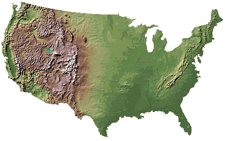
I have a question about the two maps at the bottom, the first being a map of the US and the second being a US map partially submerged.
Where did the maps come from, and how are they related to our story???
I didn't see them in either sourced link...
reply to post by DontTreadOnMe
This is not a reply as much as an add on. I wonder if someone could point me to a site that would show maps that have elevation and such SHOULD a major sea level change occur?
This is not a reply as much as an add on. I wonder if someone could point me to a site that would show maps that have elevation and such SHOULD a major sea level change occur?
reply to post by DontTreadOnMe
I live in Missouri I know of at least three caldara's in southern Missouri. Are you talking about any of them?
I live in Missouri I know of at least three caldara's in southern Missouri. Are you talking about any of them?
new topics
-
Little Johnny and Larry should team up
General Chit Chat: 3 hours ago -
Will Us use alien technology to fight in ww3?
World War Three: 3 hours ago -
posted in wrong forum
Aliens and UFOs: 4 hours ago -
Shane Gillis commercial
Jokes, Puns, & Pranks: 10 hours ago
top topics
-
Elon Says It’s ‘Likely’ He Buys Tanking MSNBC
Political Ideology: 12 hours ago, 16 flags -
Jaguar Rebrand Video Causes "WTF?" Moment - Seriously Weird
Automotive Discussion: 15 hours ago, 15 flags -
Montelukast affects brain, caused 5 year old to attempt suicide
Medical Issues & Conspiracies: 13 hours ago, 15 flags -
Shane Gillis commercial
Jokes, Puns, & Pranks: 10 hours ago, 4 flags -
Little Johnny and Larry should team up
General Chit Chat: 3 hours ago, 2 flags -
Let's start a conspiracy
General Conspiracies: 16 hours ago, 1 flags -
posted in wrong forum
Aliens and UFOs: 4 hours ago, 0 flags -
Will Us use alien technology to fight in ww3?
World War Three: 3 hours ago, 0 flags
active topics
-
Will Us use alien technology to fight in ww3?
World War Three • 2 • : DaRAGE -
Well, here we go red lines crossed Biden gives the go ahead to use long range missiles
World War Three • 329 • : Imhere -
Jaguar Rebrand Video Causes "WTF?" Moment - Seriously Weird
Automotive Discussion • 19 • : Freeborn -
International Criminal Court Issues Arrest Warrant For Netanyahu
Mainstream News • 44 • : JJproductions -
Biden's "Reckless" Decision To Escalate Russia-Ukraine War
World War Three • 121 • : angelchemuel -
Why isn't Psychiatry involved?
Social Issues and Civil Unrest • 12 • : tamusan -
What Joe Rogan said Vs The View
Dissecting Disinformation • 22 • : TheMisguidedAngel -
Little Johnny and Larry should team up
General Chit Chat • 0 • : 727Sky -
Elon Says It’s ‘Likely’ He Buys Tanking MSNBC
Political Ideology • 72 • : nugget1 -
posted in wrong forum
Aliens and UFOs • 0 • : wrayth
3
