It looks like you're using an Ad Blocker.
Please white-list or disable AboveTopSecret.com in your ad-blocking tool.
Thank you.
Some features of ATS will be disabled while you continue to use an ad-blocker.

Juan De Fuca quake threat.
page: 12
share:
If the bad weather in the past few months wasn't bad enough for the region, now there is a growing potential for a "catastrophic" quake.
Watch out for associated volcanic activity
[edit on 3/2/07 by masqua]
Watch out for associated volcanic activity
B.C. put on alert for huge quake
JANE ARMSTRONG
From Saturday's Globe and Mail
VANCOUVER — Scientists have alerted British Columbia's emergency-planning department to the possibility of a catastrophic earthquake striking the province's southwest coast next week.
While the probability of a quake is still low, rapid strides in earthquake detection have given federal scientists with the Pacific Geoscience Centre on Vancouver Island greater confidence in their ability to predict when and where one will occur. Garry Rogers, a seismologist at the centre, compared the current earthquake odds to the dangers of driving a car.
“Everyone drives their car every day, and the probability of getting in a car accident is small,” Dr. Rogers said. But during rush hour, the probability of getting into an accident is much higher. “Well, Vancouver Island is now driving in rush hour.”
Link
[edit on 3/2/07 by masqua]
Here you go, I wonder if it was anything to do this; I found these two quakes 4 days ago on that plate, and there was another one today, or
yesterday, local time.
That was 4 days ago, here is todays,
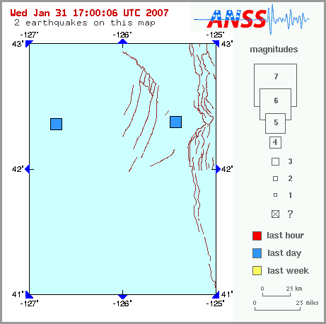
Magnitude 4.3 - OFF THE COAST OF OREGON
earthquake.usgs.gov...

Edit, you might find something with webicorders, but I don't know where most of them are:
www.pnsn.org...
[edit on 3-2-2007 by apex]
That was 4 days ago, here is todays,
Magnitude 4.3 - OFF THE COAST OF OREGON
earthquake.usgs.gov...
Edit, you might find something with webicorders, but I don't know where most of them are:
www.pnsn.org...
[edit on 3-2-2007 by apex]
Giving this thread a bit of a bump, but oh well, Another quake near the ridge that starts the Juan de Fuca plate. I wonder if the stress is building
up, and thats where it gives way first.
earthquake.usgs.gov...
earthquake.usgs.gov...
The juan de fuca plate is subducting underneath the continental crust. There will be many earthqaukes along the subducting surface, called the
Wadati-Benioff zone.
en.wikipedia.org...
en.wikipedia.org...
Isn't ole dreaded YELLOWSTONE Supervolcano in that general area?
I mean on the North american plate, on the upper west side of the nation.
Boom. I've seen the simulations.. the biblical days of darkness, the ash would spread across the entire globe's atmosphere.
Crops would be dead, starvation would set in at certain troubled regions. In western society in the cities on the Eastern U.S. and Midwest, chaos rioting and anarchy would ensue..
Yellowstone is fed by a hotspot to the best of my knowledge, similar to how Hawaii is. This is mainly about the Cascade region of Volcanoes. It can
be seen in this screenshot from Google earth:
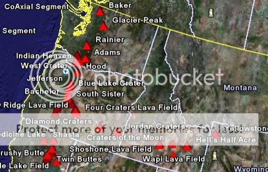
the curving set of volcanoes, (red Triangles) which separates from the Cascades region, is from the hotspot that fuels Yellowstone.
the curving set of volcanoes, (red Triangles) which separates from the Cascades region, is from the hotspot that fuels Yellowstone.
Great posts apex.
To further help out:
A schematic of the yellowstone hotspot
Whereas the cascades are feed by melt related to the subduction of the juan de fuca plate.
The chain of volcanoes striking off from the cascades to yellowstone are thus equivalent to the chain of hawaiin islands. The hotspot basically stays still, while the crust moves relative to it, leaving remant volcanic islands, or on land, volcanoes.
These structures can be very long
Geology Rocks!
Why had I never realised the Hawaiian chain was that long? there is a total length there of about 3600 miles.
But the Cascades are from a subduction zone, so pretty much the same spot will be active for as long as there is magma to feed it, but in the zone where the new crust rises and the Juan de Fuca plate sinks below the American plate. At these points earthquakes will occur.
But the Cascades are from a subduction zone, so pretty much the same spot will be active for as long as there is magma to feed it, but in the zone where the new crust rises and the Juan de Fuca plate sinks below the American plate. At these points earthquakes will occur.
I'm glad it hasn't hit... yet.
Something that hasn't been talked about a lot is the fact that scientists still don't know if the kind of tremors they've been seeing are forerunners of major quakes or if they actually help relieve the stresses that cause major quakes.
When you've got a lot of pressure building up, it's better to have it slip away a little at a time than to get it all at once, right?
Of course, it still means that times of activity are higher risk, but we still don't understand enough to say that one leads to the other.
From the wording of the article this probably isn't the exact location they mean, but anyway:
Magnitude 5.3 - OFF THE COAST OF OREGON
Depth 10km
earthquake.usgs.gov...
Interesting, EMSC have this as 60km depth.
Visible on PNSN webicorders, this is the clearest I think:
www.pnsn.org...
[edit on 14-2-2007 by apex]
Magnitude 5.3 - OFF THE COAST OF OREGON
Depth 10km
earthquake.usgs.gov...
Interesting, EMSC have this as 60km depth.
Visible on PNSN webicorders, this is the clearest I think:
www.pnsn.org...
[edit on 14-2-2007 by apex]
This one at the northern end of the plate, generally near the subduction zone:
Magnitude 4.4, Depth 10km
earthquake.usgs.gov...
Magnitude 4.4, Depth 10km
earthquake.usgs.gov...
The one I last posted here has been downgraded, but there has been another one near it.
Magnitude 4.5 - VANCOUVER ISLAND, CANADA REGION
Magnitude 4.5 - VANCOUVER ISLAND, CANADA REGION
new topics
-
How Long have You been Alive?
Other Current Events: 1 hours ago
top topics
-
Congress 2024 - We do not want me in our ladies rooms
US Political Madness: 13 hours ago, 9 flags -
My Pet Elephant For A Day…
Short Stories: 13 hours ago, 6 flags -
A call to repentance—God is patient, but His patience does not abide forever.
Religion, Faith, And Theology: 13 hours ago, 3 flags -
How Long have You been Alive?
Other Current Events: 1 hours ago, 3 flags
active topics
-
Well, here we go red lines crossed Biden gives the go ahead to use long range missiles
World War Three • 249 • : andy06shake -
WATCH LIVE: US Congress hearing on UFOs, unidentified anomalous phenomena
Aliens and UFOs • 141 • : Lazy88 -
Words of Wisdom from the Dear Leader - Transcribed for the World
Regional Politics • 4 • : berbofthegreen -
How Long have You been Alive?
Other Current Events • 3 • : ufoorbhunter -
Famous Catholic Exorcist Visits Mir-a-Lago
US Political Madness • 17 • : FlyersFan -
Dr Cambell talking about using worm meds for cancer
Medical Issues & Conspiracies • 20 • : Flyingclaydisk -
A call to repentance—God is patient, but His patience does not abide forever.
Religion, Faith, And Theology • 4 • : Flyingclaydisk -
What is your most awesome achievement or proudest moment, RE: something you were responsible for?
General Chit Chat • 20 • : Nofear51 -
-@TH3WH17ERABB17- -Q- ---TIME TO SHOW THE WORLD--- -Part- --44--
Dissecting Disinformation • 3319 • : dashen -
Russia Ukraine Update Thread - part 3
World War Three • 6829 • : Arbitrageur
2