It looks like you're using an Ad Blocker.
Please white-list or disable AboveTopSecret.com in your ad-blocking tool.
Thank you.
Some features of ATS will be disabled while you continue to use an ad-blocker.
0
share:
There is a lot of debate as to what Groom Lake really is: Area 51 as it is known is often labelled as a "UFO testing center". In a sense this is
true; they test top secret bombers or rather...they test bombers and fighters but don't want anyone to know the weapons they are testing. So in that
sense the planes may not be so secret as the weapons systems. It probably is both.
I intend to not only hypothesise this but prove it.
All images are North-Up.

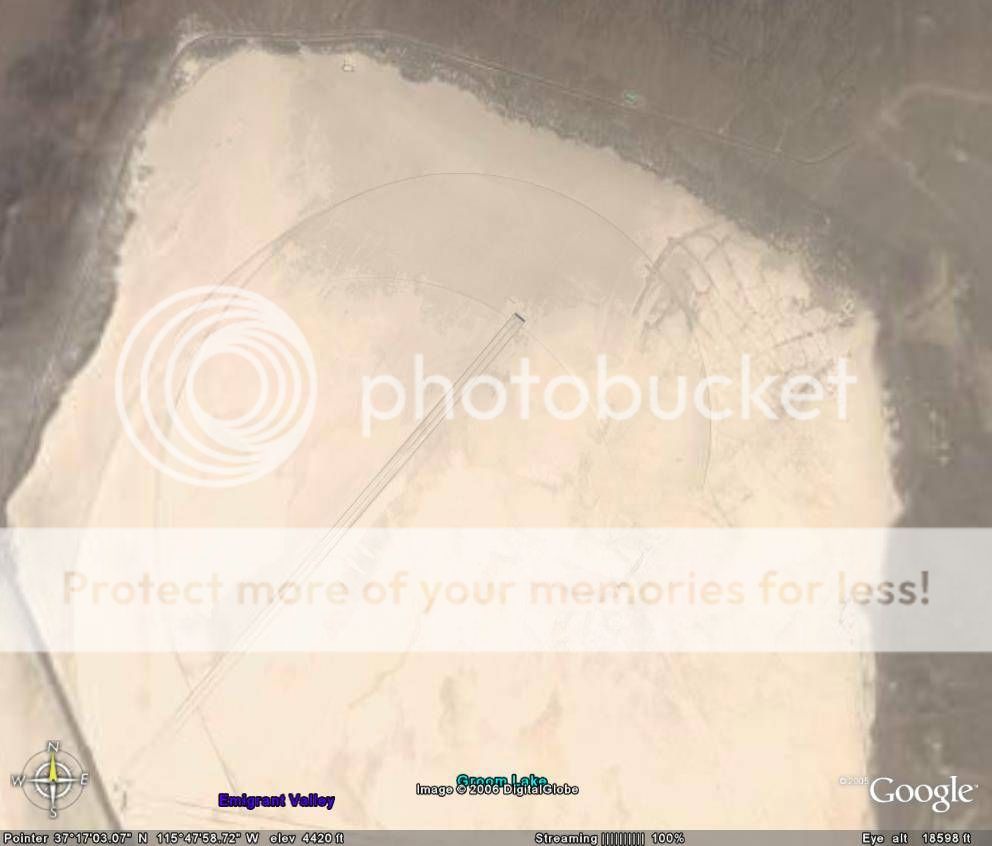
The preceeding image is the guide-lights "structure" for the Groom Lake airport facility. Notice the guide-lights' curvature which suggests the flight path of a returning plane. I suggest this pattern follows that the planes take off to the North West and make a bombing run to the South West then return from the South East following the guide lines to land on the strip in the opposite direction of take off. Notice that the approach (follow the leads of the guide lights) for the landing is to a different runway than the runway with a "run-off extension" which the extension of the runway denotes the take-off direction...in case of a failed take off there's a flat and safe surface to stop on.
When I reveal the picture of Lambs Pond in relation to Groom Lake you'll see this flight path works.
The following is an image of the Area 51 Runway.

The following image is Groom Lake lower right and Lambs Pond middle left: notice their relation to eachother.

The following image is the Lambs Pond target complex; there are three items of interest, the Target facility, the Airport target facilities, and the complex target facility.

The following image is the Lambs Pond Target facility at a large scale:

The following image is the Lambs Pond Target facility at a smaller scale:

The Airport Target facility large scale:

And the Airport's specific targets:

And finally the complex target facility:

The nature of the Airport I believe is significant. It is structured or modeled after Soviet and consequently North Korean Airport defensive structures. The ramparted enclosers; particularly those in the circlular formation; are anti-aircraft gun and artillery emplacements and/or aircraft shelters which are very common both in Russia and in North Korea.
A view of the North Korean airbase at Kaech'on proves this.
The proximity of the target base to Area 51; and their geographic orientations to eachother suggests a relationship.
Their close proximity suggests that the Area 51 base is not an aircraft testing facility but a weapons testing facility.
This is important; because most people; even skeptics of the UFO theory; do not doubt it is a plane testing facility. But the Area 51 complex is not built to specifically test planes as it lacks a range similar to that of Edwards AFB which does publically test fighters and other military aircraft.
A weapons testing facility would be far more secretive of an operation for the US; especially if the weapons to be tested were guided bombs, or Weapons of Mass Destruction to be used in tactical situations such as the elimination of an airport; or a hardened facility (which is what the Lambs Pond Target circle would imply; since extreme accuracy is needed to destroy a hardened facility).
Topographic Map Resources used:
Airport Targets
Target Complex
Lambs Pond Target Range
[edit on 28-3-2006 by Stratrf_Rus]
I intend to not only hypothesise this but prove it.
All images are North-Up.

The preceeding image is the guide-lights "structure" for the Groom Lake airport facility. Notice the guide-lights' curvature which suggests the flight path of a returning plane. I suggest this pattern follows that the planes take off to the North West and make a bombing run to the South West then return from the South East following the guide lines to land on the strip in the opposite direction of take off. Notice that the approach (follow the leads of the guide lights) for the landing is to a different runway than the runway with a "run-off extension" which the extension of the runway denotes the take-off direction...in case of a failed take off there's a flat and safe surface to stop on.
When I reveal the picture of Lambs Pond in relation to Groom Lake you'll see this flight path works.
The following is an image of the Area 51 Runway.

The following image is Groom Lake lower right and Lambs Pond middle left: notice their relation to eachother.

The following image is the Lambs Pond target complex; there are three items of interest, the Target facility, the Airport target facilities, and the complex target facility.

The following image is the Lambs Pond Target facility at a large scale:

The following image is the Lambs Pond Target facility at a smaller scale:

The Airport Target facility large scale:

And the Airport's specific targets:

And finally the complex target facility:

The nature of the Airport I believe is significant. It is structured or modeled after Soviet and consequently North Korean Airport defensive structures. The ramparted enclosers; particularly those in the circlular formation; are anti-aircraft gun and artillery emplacements and/or aircraft shelters which are very common both in Russia and in North Korea.
A view of the North Korean airbase at Kaech'on proves this.
The proximity of the target base to Area 51; and their geographic orientations to eachother suggests a relationship.
Their close proximity suggests that the Area 51 base is not an aircraft testing facility but a weapons testing facility.
This is important; because most people; even skeptics of the UFO theory; do not doubt it is a plane testing facility. But the Area 51 complex is not built to specifically test planes as it lacks a range similar to that of Edwards AFB which does publically test fighters and other military aircraft.
A weapons testing facility would be far more secretive of an operation for the US; especially if the weapons to be tested were guided bombs, or Weapons of Mass Destruction to be used in tactical situations such as the elimination of an airport; or a hardened facility (which is what the Lambs Pond Target circle would imply; since extreme accuracy is needed to destroy a hardened facility).
Topographic Map Resources used:
Airport Targets
Target Complex
Lambs Pond Target Range
[edit on 28-3-2006 by Stratrf_Rus]
And are you also aware that Nellis AFB and Red Flag are right up against Area 51? And that Red Flag uses those targets?
Nellis AFB is about 200 miles to the south of the bombing range. Either way it is not as if one facility is used by only one other facility, even if
planes flew out of Nellis on a testing run to Lambs Pond it would not rule out the close relationship between Groom Lake to Lambs Pond.
[edit on 28-3-2006 by Stratrf_Rus]
[edit on 28-3-2006 by Stratrf_Rus]
I cant work out what you are referring to as guide lights. You are either talking about the runways marked on the lake bed used during strong
crosswinds or you are referring to markings commonly known as "the hook" which is the curved lines that spiral around the lake bed, these arent for
guiding in a plane, they are used to slow down an aircraft if it has used up all the runoff after the runway and is still moving for example if its
brakes have failed.
Also I dont understand why you think pilots so experienced that they are trusted to fly experimental aircraft wouldnt be able to follow a simple flight plan and would need a line drawn on the ground to follow!?
-George
Also I dont understand why you think pilots so experienced that they are trusted to fly experimental aircraft wouldnt be able to follow a simple flight plan and would need a line drawn on the ground to follow!?
-George
Originally posted by Stratrf_Rus
There is a lot of debate as to what Groom Lake really is: Area 51 as it is known is often labelled as a "UFO testing center". In a sense this is true; they test top secret bombers or rather...they test bombers and fighters but don't want anyone to know the weapons they are testing. So in that sense the planes may not be so secret as the weapons systems. It probably is both.
I intend to not only hypothesise this but prove it.
For the most part this has already been proven here on ATS! A while back we carried out the Groom Lake Research Project. We did a detailed, in depth study of the base, it's history, and as many of it's Black Projects as we could find. The Data is archived here at ATS!
If you want to take a look, all of our data can be found right HERE
Before you grab a blank sheet of paper and dive into your own research, you might want to start with the Research data we have in our archives.
I'm NOT in any way trying to discourage you! I just want to save you some time by pointing you to some data you can build on!
Tim
Just a note; lots of people who suspect dealings with UFOs and aliens to occur much deeper recesses of the base, not up on ground level where various
other types of testing are said to be performed.
new topics
-
World's Best Christmas Lights!
General Chit Chat: 2 hours ago -
Drone Shooting Arrest - Walmart Involved
Mainstream News: 3 hours ago -
Can someone 'splain me like I'm 5. Blockchain?
Science & Technology: 4 hours ago -
Squirrels becoming predators
Fragile Earth: 4 hours ago -
Labour's Anti-Corruption Minister Named in Bangladesh Corruption Court Papers
Regional Politics: 5 hours ago -
Have you noticed?? Post Election news coverage...
World War Three: 5 hours ago -
Georgia appeals court disqualifies DA Fani Willis from Trump election interference case
US Political Madness: 8 hours ago
top topics
-
Georgia appeals court disqualifies DA Fani Willis from Trump election interference case
US Political Madness: 8 hours ago, 24 flags -
Have you noticed?? Post Election news coverage...
World War Three: 5 hours ago, 11 flags -
Squirrels becoming predators
Fragile Earth: 4 hours ago, 8 flags -
Labour's Anti-Corruption Minister Named in Bangladesh Corruption Court Papers
Regional Politics: 5 hours ago, 6 flags -
Drone Shooting Arrest - Walmart Involved
Mainstream News: 3 hours ago, 5 flags -
World's Best Christmas Lights!
General Chit Chat: 2 hours ago, 5 flags -
Can someone 'splain me like I'm 5. Blockchain?
Science & Technology: 4 hours ago, 3 flags
active topics
-
Can someone 'splain me like I'm 5. Blockchain?
Science & Technology • 32 • : TzarChasm -
Smartest Man in the World Tells His Theory About What Happens At Death
Philosophy and Metaphysics • 41 • : TzarChasm -
Drone Shooting Arrest - Walmart Involved
Mainstream News • 13 • : nerbot -
ILLUMINATION – Reverse Perception Of Cyclic Probability – CEO ASSASSINATION
Secret Societies • 32 • : Compendium -
Have you noticed?? Post Election news coverage...
World War Three • 7 • : nugget1 -
-@TH3WH17ERABB17- -Q- ---TIME TO SHOW THE WORLD--- -Part- --44--
Dissecting Disinformation • 3760 • : 777Vader -
Russias War Against Religion in Ukraine
World War Three • 46 • : andy06shake -
Squirrels becoming predators
Fragile Earth • 24 • : rickymouse -
The Mystery Drones and Government Lies --- Master Thread
Political Conspiracies • 144 • : charlyv -
US Federal Funding set to Expire December 20th. Massive CR on the way.
Mainstream News • 26 • : burntheships
0
