It looks like you're using an Ad Blocker.
Please white-list or disable AboveTopSecret.com in your ad-blocking tool.
Thank you.
Some features of ATS will be disabled while you continue to use an ad-blocker.
27
share:
weatherboy.com...
This article popped up on my news feed for my nerdy geology Google map.
The New Madrid Seismic Zone is seeing a rise in small earthquakes.
Typically the zone experiences 200 or so a year.
This zone is a sleeping monster. Most recently a 6.8 in 1895. And before that a series of four 7.0+ magnitude quakes that were felt as far away as Boston.
Around 500 million years ago the continental boundary (and associated plate boudary) went through The center of Texas following relatively the same curve of the Gulf Coast. In two places the continent tried to tear apart. On the Oklahoma Aulocogen and The Reelfoot rift, with the latter of the two coming closest to splitting.
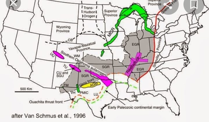
But it didn't and a remains a weak point in the crust under the region.
Probability:
San Andreas has the 70% likelihood of a 7.5 or greater in the next 30 years, but the New Madrid holds the inauspicious (and disputed) likelihood of a 90% chance of a 6.0-7.0 in the next 50 years at highest estimates. (Likely closer to 70% as well).
news.stanford.edu...
While the 8.0 magnitude ones hit on a 500 (or 250 to 4000) year regularilty, the random 6.8 happens much more frequently. Even if overestimated.
While none of these quakes remotely suggest foreshock, less is known about the stresses of those seismic zones and intraplate quakes. Or if there is even a regularity to the events that happen. What remains is a guess a plate sliding along the mantle has remnant weak spots prone to these rare tremors. If the geological foundation has damage, even Cambrian or Ordovician damage (Appalachians) know it's a 100 year possibility even if the plate boundary has moved on.
In California the biggest faults all run parallel (or are related) to the transformation fault. The land is newer. The rate of slip is faster. In those Eastern America zones the crust is WAY older. Because of this they are orders of magnitude more destructive. The old crust has had much of its geological past burried deep under the North American continent. Unlike our quakes which are attenuated by new and continuous formation along an active transformation boundary, the ones back east are on faults 10 times older and travel 10 times further.
Ours will come, but a 7.7 near Palm Springs is far less concerning than a 6.7 right outside Memphis.
I dont think anything will come of this recent uptick but it's more than a possibility.
IMO The region is not "shutting down". That doesn't take 500 million years to occur. Wishful thinking says that. A weak spot is a weak spot. A scar is not going to heal itself completely. A weakness in the bottom of the foundation gets exacerbated if you drag the house along the ground.
Pray for sunshine and carry an umbrella.
This article popped up on my news feed for my nerdy geology Google map.
The New Madrid Seismic Zone is seeing a rise in small earthquakes.
Typically the zone experiences 200 or so a year.
This zone is a sleeping monster. Most recently a 6.8 in 1895. And before that a series of four 7.0+ magnitude quakes that were felt as far away as Boston.
Around 500 million years ago the continental boundary (and associated plate boudary) went through The center of Texas following relatively the same curve of the Gulf Coast. In two places the continent tried to tear apart. On the Oklahoma Aulocogen and The Reelfoot rift, with the latter of the two coming closest to splitting.

But it didn't and a remains a weak point in the crust under the region.
Probability:
San Andreas has the 70% likelihood of a 7.5 or greater in the next 30 years, but the New Madrid holds the inauspicious (and disputed) likelihood of a 90% chance of a 6.0-7.0 in the next 50 years at highest estimates. (Likely closer to 70% as well).
news.stanford.edu...
While the 8.0 magnitude ones hit on a 500 (or 250 to 4000) year regularilty, the random 6.8 happens much more frequently. Even if overestimated.
While none of these quakes remotely suggest foreshock, less is known about the stresses of those seismic zones and intraplate quakes. Or if there is even a regularity to the events that happen. What remains is a guess a plate sliding along the mantle has remnant weak spots prone to these rare tremors. If the geological foundation has damage, even Cambrian or Ordovician damage (Appalachians) know it's a 100 year possibility even if the plate boundary has moved on.
In California the biggest faults all run parallel (or are related) to the transformation fault. The land is newer. The rate of slip is faster. In those Eastern America zones the crust is WAY older. Because of this they are orders of magnitude more destructive. The old crust has had much of its geological past burried deep under the North American continent. Unlike our quakes which are attenuated by new and continuous formation along an active transformation boundary, the ones back east are on faults 10 times older and travel 10 times further.
Ours will come, but a 7.7 near Palm Springs is far less concerning than a 6.7 right outside Memphis.
I dont think anything will come of this recent uptick but it's more than a possibility.
IMO The region is not "shutting down". That doesn't take 500 million years to occur. Wishful thinking says that. A weak spot is a weak spot. A scar is not going to heal itself completely. A weakness in the bottom of the foundation gets exacerbated if you drag the house along the ground.
Pray for sunshine and carry an umbrella.
edit on 6-9-2022 by Degradation33 because: (no reason given)
There was a thread here years back where people were mentioning this region possibly having a quake within a couple of decades. The rise in little
quakes could be a forerunner to a larger quake in the near future. But that does not mean it will be a real big quake though, it just increases the
chances of something over six.
a reply to: Degradation33
The Pacific ring of fire has been active the last 5 yrs. Bounce East, San Andreas. Head farther the Yellowstone Super Volcano....and the the New Madrid round the Mississippi? Oh boy...I'm thinking 1 ripples, the other pulses...reaction and opposite reaction.
Just 1 + another catalyst...we're doomed.
edit on 09223630America/ChicagoTue, 06 Sep 2022 22:08:36 -050008202200000036 by mysterioustranger
because: (no reason given)
Reelfoot Lake in TN was formed when the New Madrid caused the Mississippi River to flow backwards in 1811 or 1812 in a series of quakes.
a reply to: Degradation33
a reply to: mysterioustranger
a reply to: mysterioustranger
The Pacific ring of fire has been active the last 5 yrs. Bounce East, San Andreas. Head farther the Yellowstone Super Volcano....and the the New Madrid round the Mississippi? Oh boy...I'm thinking 1 ripples, the other pulses...reaction and opposite reaction.
Just 1 + another catalyst...we're doomed.
Well, sure as planets come, I know that they end, and if I'm here when that happens, will you promise me this, my friend? Please bury me with it! I just don't need any of that Mad Max bull#
edit on 6 9 2022 by tamusan because: (no reason given)
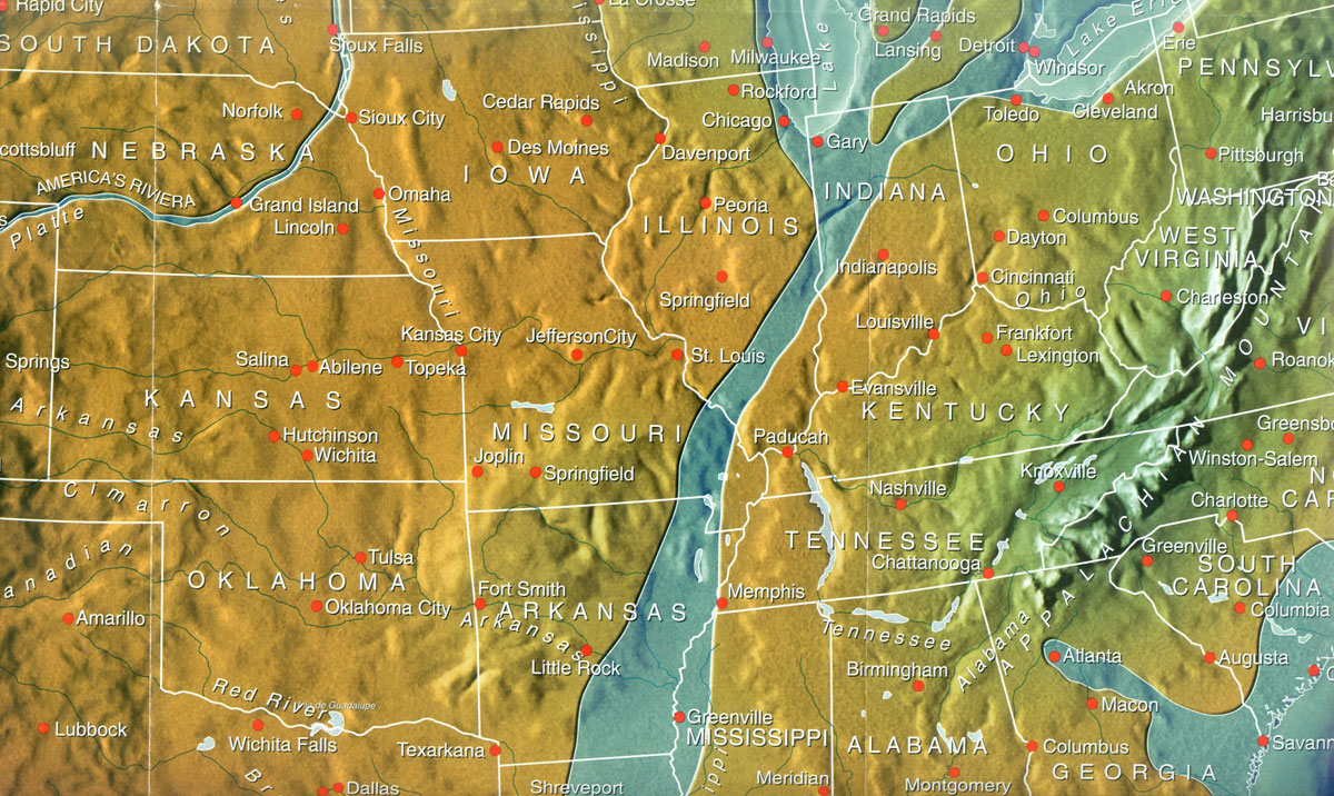
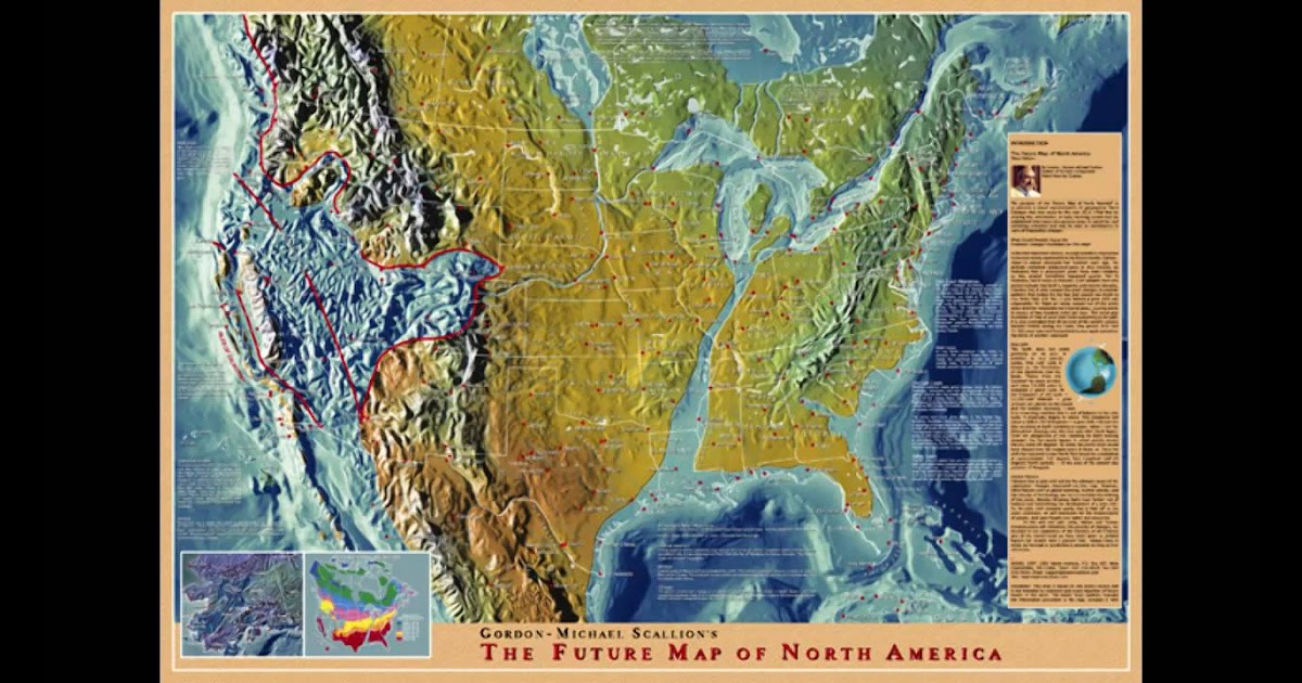
Remember the Gordon Micheal Scallion Future maps, I was always fascinated by those, IIRC correctly much of the widening h of the Mississippi was based
on a New Madrid monster quake. Memphis will likely cease to exist in a worse case scenario


originally posted by: Ahabstar
Reelfoot Lake in TN was formed when the New Madrid caused the Mississippi River to flow backwards in 1811 or 1812 in a series of quakes.
That's cool. Looked it up. The Indian legend of an angry spirit stomping it's foot is great. Their answer for land deformation and a sudden flood.
Wonder what happens next time the Mississippi flows backwards? That's not something one can plan for because you never know where landforms will collapse.
My favorite North American lake is not made the same way as it great brethren.
Lake Superior is the most geologically significant. Created by the oldest failed rift in present day North America. The North American Craton (Laurentia) is old. It has been part of several supercontinents And it's been separate several times. About 900 million into its life (1.1 bya) it tried to and almost split apart. What remains is the deepest failed rift on earth. It came very close to filling with ocean. There is enough basalt in the scar from that to fill all great lakes 44 times over. Lake Superior sits inside a bowl of igneous rock.
The most mind blowing part of that all was continent locations on earth when that happened.
Lake Superior was at the latitude of Colombia and Austrailia was at the latitude of Lake Superior.
North America is dealing with failed rifts and weak spots that happened when the continents were in completely different positions. When the Reelfoot rift formed the rift ran east to west virtually on the equator.
* Addendum to earlier post.
Why the Reelfoot Rift is different and more active than other failed rifts. Gonna copout here and post my fact check source.
www.science.gov...
Our images span several Proterozoic and early Cambrian rift zones (Mid-Continent Rift, Rough Creek Graben—Rome trough, Birmingham trough, Southern Oklahoma Aulacogen, and Reelfoot Rift). While ancient rifts are generally associated with low crustal velocity because of the presence of thick sedimentary sequences, the Reelfoot Rift is unique in its association with low mantle seismic velocity. Its mantle low-velocity zone (LVZ) is exceptionally pronounced and extends down to at least 200 km depth. This LVZ is of variable width, being relatively narrow (∼50km">∼50km wide) within the northern Reelfoot Rift, which hosts the New Madrid Seismic Zone (NMSZ). We hypothesize that this mantle volume is weaker than its surroundings and that the Reelfoot Rift consequently has relatively low elastic plate thickness, which would tend to concentrate tectonic stress within this zone. No other intraplate ancient rift zone is known to be associated with such a deep mantle low-velocity anomaly, which suggests that the NMSZ is more susceptible to external stress perturbations than other ancient rift zones.
Why the motion of the crust over the mantle centers stress within the narrow failed rift.
edit on 7-9-2022 by Degradation33 because: (no
reason given)
a reply to: Degradation33
Keep in mind there been a major shift from the south to the north along the land that is tied to the Appalachian mountain chain. Ohio was a shallow sea at one time. But was more than 20 degrees south of the equator in line with present day Australia rather than North Korea. Horn coral is so common all over Ohio, it isn’t a protected fossil in the slightest. Same with ancient mussel fossils. We broke many of those open for the reddish purple crystals inside that were probably fossilized component minerals of the mussel itself.
But live freshwater mussels are VERY protected. And raccoons can eat all they want of course. Just be sure you have been lost a week or more and say you ate bugs or something. Never mention them. Say you thought they were poisonous if pushed.
Could the magnetic pole shift be affecting this? I’m just wondering if the magnetic poles traveling west ( or wherever they’re shifting to) could
be pulling in magma and making the fault lines wake up ?
a reply to: Degradation33
It's a good thing 237 people and/or businesses are moving out of Illinois every day.
It's a good thing 237 people and/or businesses are moving out of Illinois every day.
If you're interested in predictions, Edgar Cayce predicted a quake on the New Madrid fault would split the US in half and empty the great lakes down
the Mississippi River into the Gulf of Mexico.
I'd hate to see that happen.
I'd hate to see that happen.
originally posted by: nugget1
If you're interested in predictions, Edgar Cayce predicted a quake on the New Madrid fault would split the US in half and empty the great lakes down the Mississippi River into the Gulf of Mexico.
I'd hate to see that happen.
Luckily for everyone Edgar Cayce had less knowledge than the technical advisor for San Andreas
There needs to be a triple junction for a rift to form, if not part of a spreading ridge. And triple junctions need transformation faults, like the San Andreas. There are no plate boundaries there anymore.
While certainly possible for another 8.2 to displace a lot of land and water, the land deformation won't get passed Northern Illinois, or effect the banks of Lake Michigan. While 129,000 square miles is a massive area subject to land deformation from an 8.2, that couldn't displace the waters of The Great Lakes.
Another Reelfoot Lake could form with all that displacement easily. And the Mississippi will again flow backwards for a day.
* The most likely rift in the US could be at the San Andreas and Garlock fault. California would rift starting at Lancaster and spread towards the high desert. This would be caused by the north trending motion of Pacific Plate, and southward motion of the North American. Basically the plate boundary wants to transfer stress onto another fault, and create a new plate boundary. And then everything West of the new boundary starts pulling away from the Eastern half as it follows the motion of the Pacific plate instead of the North American. So it pulls apart, like Baja pulled off of Mexico.
As of now the western side is just supposed to slide North. But Ridgecrest raised questions if the plate boundary was moving eastward via the Garlock Fault.
Wikipedia is better at this than me.
In plate tectonics theory during the breakup of a continent, three divergent boundaries form, radiating out from a central point (the triple junction). One of these divergent plate boundaries fails (see aulacogen) and the other two continue spreading to form an ocean. Trough is the failed arm of this junction.
edit on 7-9-2022 by Degradation33 because: (no reason given)
a reply to: Degradation33
Clarification to above post on most likely way California "falls into the ocean".
The Earth has a few plans for the State.
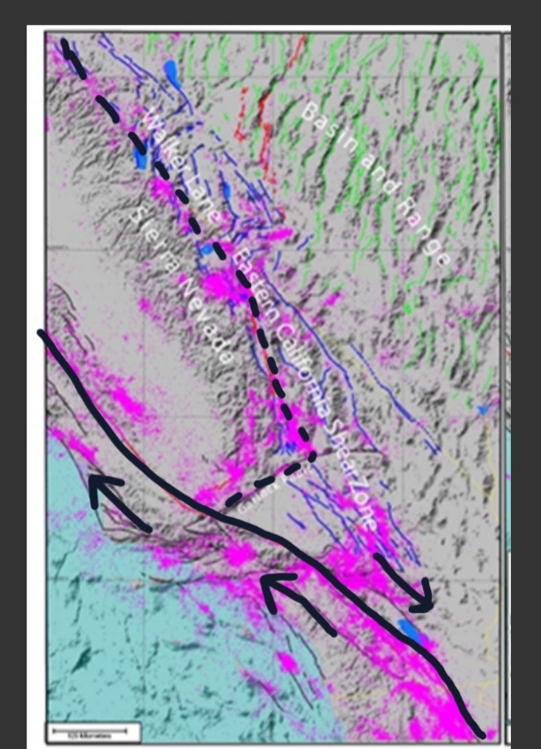
Scenario 1: The San Andreas remains the dominant transform boundary and LA pulls even with SF. [Solid line]
Scenario 2: Walker Lane (East California Shear Zone) dominates the breakup and the spreading center in the gulf of California unzips the state through the central valley into a jumbled mess startling the new Gulf of Nevada. [Dotted line]
Or a combination of both.
And in 50 million years the West coast looks like this:
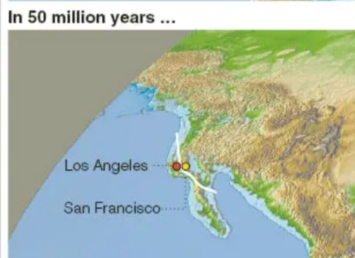
The White line is the present day position of the San Andreas Fault.
In the end the only rift to worry about threatening America (in millions of years) is a continuation of the one already present in The Gulf of California further splitting the State along a few possible routes.
In most scenarios San Andreas Fault, Garlock Fault, and Walker Lane play major roles.
There also a Basin and Range scenario for continental breakup.
* I should probably own that I said Tranformation instead of Tranform fault/boundary in all previous posts.
That's it for this thread. Thank you all for S&F.
Clarification to above post on most likely way California "falls into the ocean".
The Earth has a few plans for the State.

Scenario 1: The San Andreas remains the dominant transform boundary and LA pulls even with SF. [Solid line]
Scenario 2: Walker Lane (East California Shear Zone) dominates the breakup and the spreading center in the gulf of California unzips the state through the central valley into a jumbled mess startling the new Gulf of Nevada. [Dotted line]
Or a combination of both.
And in 50 million years the West coast looks like this:

The White line is the present day position of the San Andreas Fault.
In the end the only rift to worry about threatening America (in millions of years) is a continuation of the one already present in The Gulf of California further splitting the State along a few possible routes.
In most scenarios San Andreas Fault, Garlock Fault, and Walker Lane play major roles.
There also a Basin and Range scenario for continental breakup.
* I should probably own that I said Tranformation instead of Tranform fault/boundary in all previous posts.
That's it for this thread. Thank you all for S&F.
edit on 8-9-2022 by Degradation33 because: (no reason given)
edit on
8-9-2022 by Degradation33 because: (no reason given)
new topics
-
Biden Face Planted Somewhere
Other Current Events: 1 hours ago -
A great artist and storyteller, for kids of all ages
General Entertainment: 2 hours ago -
What Is 'Quad Demic'? Mask Mandate Returns In These US States
Diseases and Pandemics: 6 hours ago -
The Future of fashion .
Social Issues and Civil Unrest: 6 hours ago -
Bin Cyber Junk…
Short Stories: 7 hours ago -
The Undertones - Teenage Kicks
Music: 8 hours ago -
Volcano Watch 2025
Fragile Earth: 8 hours ago
top topics
-
What Is 'Quad Demic'? Mask Mandate Returns In These US States
Diseases and Pandemics: 6 hours ago, 9 flags -
The Future of fashion .
Social Issues and Civil Unrest: 6 hours ago, 6 flags -
Judge rules president-elect Donald Trump must be sentenced in 'hush money' trial
US Political Madness: 16 hours ago, 5 flags -
Volcano Watch 2025
Fragile Earth: 8 hours ago, 5 flags -
Bin Cyber Junk…
Short Stories: 7 hours ago, 5 flags -
Biden Face Planted Somewhere
Other Current Events: 1 hours ago, 3 flags -
The Undertones - Teenage Kicks
Music: 8 hours ago, 2 flags -
A great artist and storyteller, for kids of all ages
General Entertainment: 2 hours ago, 2 flags
active topics
-
The Why Files Lacerta Reveals the Truth of our Creation
Aliens and UFOs • 12 • : Astrocometus -
The Future of fashion .
Social Issues and Civil Unrest • 17 • : Flyingclaydisk -
Judge rules president-elect Donald Trump must be sentenced in 'hush money' trial
US Political Madness • 16 • : RazorV66 -
Tesla Cybertruck Explodes in Front of Trump Hotel in Las Vegas
Mainstream News • 219 • : Vermilion -
Strange fog all over the northern hemisphere
General Conspiracies • 48 • : fringeofthefringe -
What Is 'Quad Demic'? Mask Mandate Returns In These US States
Diseases and Pandemics • 24 • : Flyingclaydisk -
Vehicle Strikes people in New Orleans
Mainstream News • 297 • : Flyingclaydisk -
Biden Face Planted Somewhere
Other Current Events • 5 • : Guyfriday -
NJ Drones tied to Tesla explosion at Trump Las vegas
General Conspiracies • 43 • : Flyingclaydisk -
-@TH3WH17ERABB17- -Q- ---TIME TO SHOW THE WORLD--- -Part- --44--
Dissecting Disinformation • 3929 • : Thoughtful3
27
