It looks like you're using an Ad Blocker.
Please white-list or disable AboveTopSecret.com in your ad-blocking tool.
Thank you.
Some features of ATS will be disabled while you continue to use an ad-blocker.
share:
originally posted by: humanoidlord
definitely a base camp of some kind, anyone can correlate the coordinates with any know scientific bases?
It is so out in the open and if there isn't a name for the base that makes it a mystery.
Probably one of our 'competitor' nations or it is one of our secret scientific base but I am sure someone will be along and tell us nothing to see here, shortly. I am not holding out the alien concept until I see one I believe to be one. Ghosts too but I do think there is some merit to inter-dimensional beings since I believe in the concepts laid out in the Quantum Theory.
Who here now debunks just about all truths of science that might help humanity that used to help us separate science fact from fiction? That one will be around to tell us our eyes don't see that, if my guess is correct.
edit on 3-9-2018 by Justoneman because: (no reason given)
originally posted by: CynConcepts
Most dyed diesel, sold in the U.S., comes with a red coloring and is not usually available for purchase by the public. However, you may occasionally see this dyed gasoline at a fuel station. By law, this dyed gas is only for use in off-road vehicles, such as farm tractors, heavy construction equipment, and generators. Because it is not supposed to be used for on-road vehicles, this fuel is not taxed within the United States.
Diesel that is designated for use by U.S. government vehicles is dyed blue instead of red. This color variation helps to keep clear fuel used by the general public separate from the gas used by government on-road vehicles.
So yes the red may be most likely a dyed diesel spill.
I am not aware of dyed diesel but having a working knowledge of the fuel from the past it had a color about it that would seem amber or red. The dye could still have been there and since I don't make diesel fuel nor have I ever, I defer to you on that. I do know there has been some changes to the compounds in the fuel to make it easier to pass EPA regulations.
originally posted by: theantediluvian
a reply to: Xcathdra
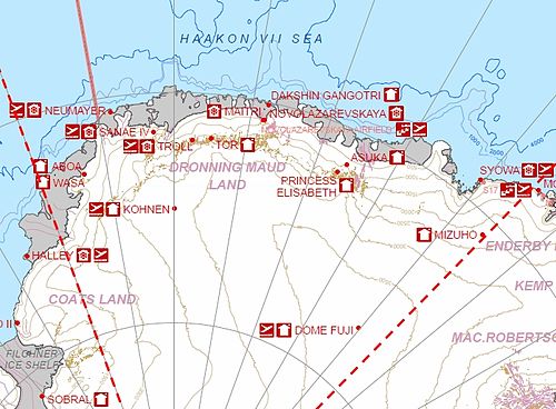
No problem. I looked up Queen Maud Land stations for a list and found this picture:
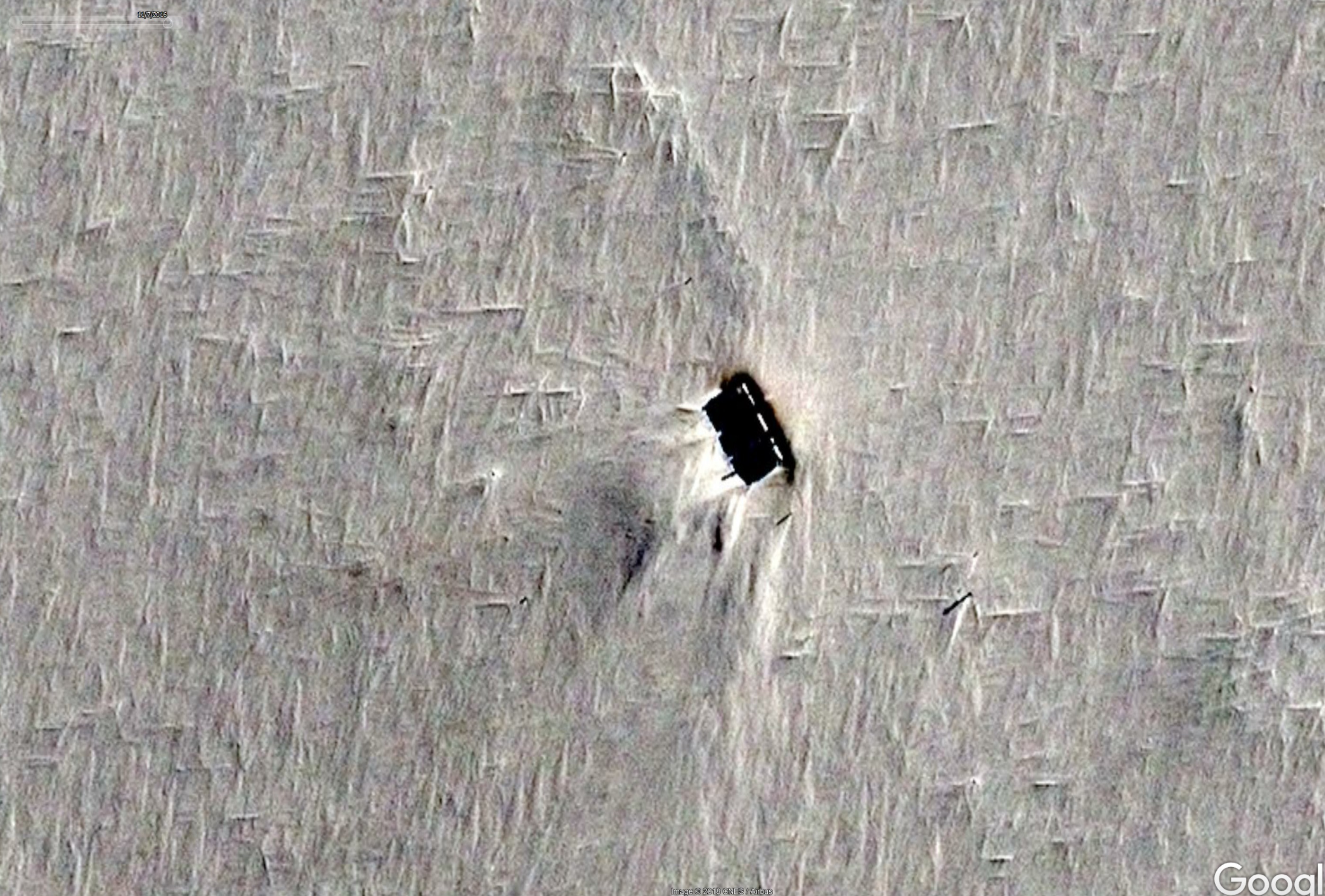
Kohnen looked about right so I checked out the Wikipedia page and saw the coordinates. If you look at this image again:
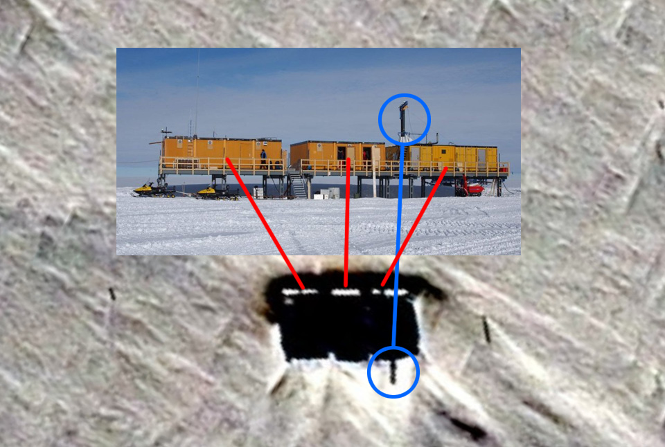
I think what is seen there is the station itself with the sun hitting it at very oblique angle so that it's casting a very long shadow.
If you look closely at the shadow, you can make out the gaps between the buildings and the hoist. What looks like three white dashes in a line (right side of feature) would be snow on the roofs.
The line of features below I would assume are from ice core drilling.
ETA:
NICE Ante. Thanks for helping settle that.
Next mystery:
It looks like as late as 2016 there was reason to take pics? I wonder what was going on if it has been shut down so long?
originally posted by: Quadlink
Translated text.....
The Kohnen Station is a German polar research station in the Antarctic. It is named after Heinz Kohnen, who for a long time was head of the logistics department of the Alfred Wegener Institute (AWI). The station was built in 2001 on the Queen Maud Land (Norwegian: Dronning Maud Land) from the containers of the former Filchner station, which had to be rescued in 1999. It lies at 75 ° 00'S, 00 ° 04'O at 2892 meters altitude, about 757 km southeast of the Neumayer station. The Kohnen Station serves as a logistic basis for the ice drilling in Queen Maud Land of the European Project for Ice Coring in Antarctica (EPICA). It is a European deep drilling project to reconstruct the climate of the Antarctic Atlantic Ocean sector during the last one hundred thousand years. www.awi-bremerhaven.de...
Nice find, second mystery solved.
a reply to: Kandinsky
I feel ya! On Antarctica though, I think the reason there is such interest from world powers are for a number of reasons but history and science underpins a lot of it. Stating the obvious I know. As for aliens I think a lot of people have been mislead in their quest to find something they believe is completely different than themselves, what's to say technology hasn't surpasses the point we're at in a previous time and tensions escalated like they are now which caused some forward thinking being to seek somewhere to survive? I see NASA are now saying the Mars and Moon are on the cards. If WWIII means we can't live on earth I can see someone trying to continue life elsewhere.
I feel ya! On Antarctica though, I think the reason there is such interest from world powers are for a number of reasons but history and science underpins a lot of it. Stating the obvious I know. As for aliens I think a lot of people have been mislead in their quest to find something they believe is completely different than themselves, what's to say technology hasn't surpasses the point we're at in a previous time and tensions escalated like they are now which caused some forward thinking being to seek somewhere to survive? I see NASA are now saying the Mars and Moon are on the cards. If WWIII means we can't live on earth I can see someone trying to continue life elsewhere.
a reply to: Xcathdra
That is Kohnen (German) research Station, same coordinates. Do a goog le image search and you can see pics of the stilted structures
www.abovetopsecret.com...
That is Kohnen (German) research Station, same coordinates. Do a goog le image search and you can see pics of the stilted structures
www.abovetopsecret.com...
The world atlas is fake. There are no continents at the poles, only holes. NASA is a #sciencefiction created after WW2 to hide the secrets of the
world: The earth is a hollow #dysonsphere and has an inner sun. The moon is small and close (within the Van Allen Belts & within the earth's outer
atmosphere). Gravity is really Electromagnetism (Electric Universe), unrelated to Mass. Space-time does not exist. Dark matter does not exist. Global
warming (ozone layer) was caused by Aerosol #geoengineering, not carbon. There is no ocean floor between continents (Hollow). We are not welcome on
Mars or the Moon, so we faked every shot. Earth used to be a (flat-oriented) Moon of the planet Saturn. Saturn (EL) is the God of Abraham and the
mother planet that created Earth. Every human civilization watched Saturn, Venus, and Mars dance in the sky, and they drew what they saw from a giant
cross (Christianity), to a star+crescent (Islam) to the black cube of Saturn (Judaism kabbalah => cube allah => cube god). Gotta use your own brain
and do original research, otherwise NASA just another blind faith religion.
originally posted by: soberbacchus
a reply to: Xcathdra
That is Kohnen (German) research Station, same coordinates. Do a goog le image search and you can see pics of the stilted structures
www.abovetopsecret.com...
Yup already covered a few pages back.
the guy that uploaded the video in the OP is uploading some very interesting videos right now:
www.youtube.com...
www.youtube.com...
while i don't really believe anything he says, his speculation is still quite interesting to hear, much more cool than some guy pointing at random rocks on mars and screaming crap
www.youtube.com...
www.youtube.com...
while i don't really believe anything he says, his speculation is still quite interesting to hear, much more cool than some guy pointing at random rocks on mars and screaming crap
edit on 6-9-2018 by humanoidlord because: (no reason given)
a reply to: humanoidlord
it's spelled 0, but yeah. If that applies, i'm not sure. Mona Lisa smiles there but nothing nice but that granted yes is nice.
it's spelled 0, but yeah. If that applies, i'm not sure. Mona Lisa smiles there but nothing nice but that granted yes is nice.
new topics
-
A Flash of Beauty: Bigfoot Revealed ( documentary )
Cryptozoology: 2 hours ago -
Fire insurance in LA withdrawn months ago
General Conspiracies: 5 hours ago
top topics
-
Fire insurance in LA withdrawn months ago
General Conspiracies: 5 hours ago, 6 flags -
Bizarre Labour Party Tic Toc Video Becomes Even More Embarrassing
Regional Politics: 13 hours ago, 4 flags -
A Flash of Beauty: Bigfoot Revealed ( documentary )
Cryptozoology: 2 hours ago, 4 flags
active topics
-
Judge rules president-elect Donald Trump must be sentenced in 'hush money' trial
US Political Madness • 86 • : Flyingclaydisk -
Fire insurance in LA withdrawn months ago
General Conspiracies • 19 • : Flyingclaydisk -
A Flash of Beauty: Bigfoot Revealed ( documentary )
Cryptozoology • 2 • : Flyingclaydisk -
Trump says ownership of Greenland 'is an absolute necessity'
Other Current Events • 86 • : WeMustCare -
The Truth about Migrant Crime in Britain.
Social Issues and Civil Unrest • 44 • : angelchemuel -
My personal experiences and understanding of orbs
Aliens and UFOs • 41 • : WeMustCare -
-@TH3WH17ERABB17- -Q- ---TIME TO SHOW THE WORLD--- -Part- --44--
Dissecting Disinformation • 3982 • : WeMustCare -
Los Angeles brush fires latest: 2 blazes threaten structures, prompt evacuations
Mainstream News • 298 • : Flyingclaydisk -
The Mystery Drones and Government Lies --- Master Thread
Political Conspiracies • 156 • : WeMustCare -
S.C. Jack Smith's Final Report Says Trump Leads a Major Conspiratorial Criminal Organization!.
Political Conspiracies • 48 • : WeMustCare


