It looks like you're using an Ad Blocker.
Please white-list or disable AboveTopSecret.com in your ad-blocking tool.
Thank you.
Some features of ATS will be disabled while you continue to use an ad-blocker.
29
share:
Well I found this to be interesting, not too sure how they dated the sites but its really cool when we has humans can find ties to our past.
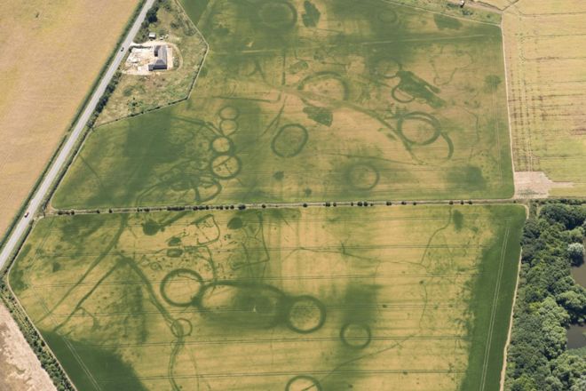
 Features in a ceremonial landscape near Oxford date from 4000BC to 700BC
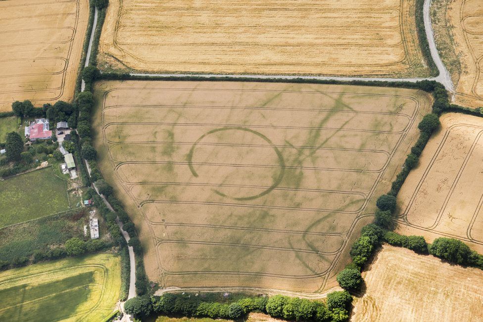
 An Iron Age round settlement was discovered at St Ive, Cornwall
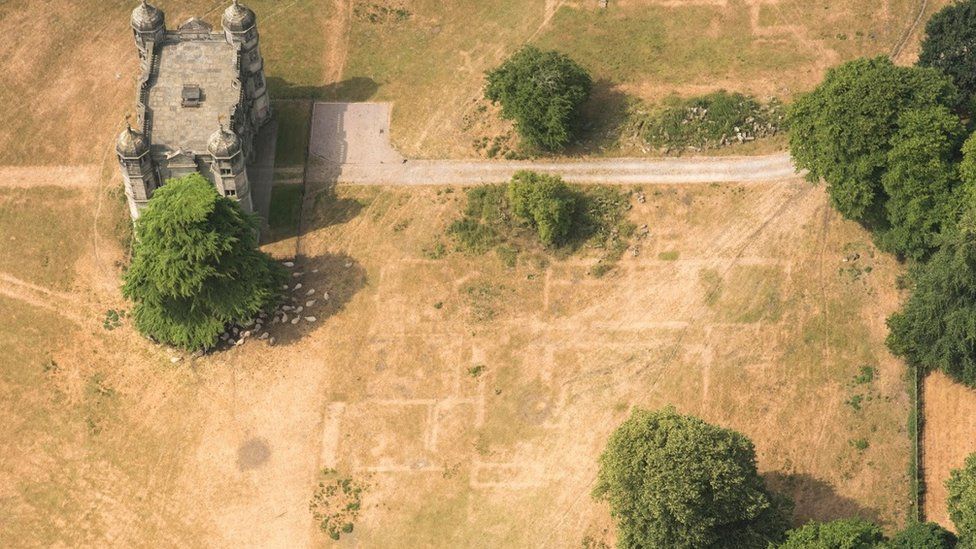
 The buried foundations of Tixall Hall, built in 1555, have also become visible
Article Link
~Morpheus
The heatwave has continued to reveal details of England's ancient past to archaeologists.
Surveys from the air have revealed Neolithic ceremonial monuments, Iron Age settlements, square burial mounds and a Roman farm for the first time. Historic England said the weather "provided the perfect conditions" to see the crop marks because of the lack of moisture in the soil.


Article Link
~Morpheus
originally posted by: MorpheusUSA
not too sure how they dated the sites
I have watched and read quite a bit about British archaeology and the noticeable circular design is well known Iron Age architecture, google 'Iron Age Roundhouse'. Everything in these pictures are familiar to archaeologists and they are pretty well known in relation to the age they were built by the shape of their foundations. The neolithic mounds, procession ways and corral shaped foundations, the Iron Age round house and large circular designs, the Roman ones are probably some of the most studied as some are still in very good condition and are more than just foundations.
I saw a satellite picture during the heatwave that showed that Britain had turned from green to brown, I didn't really think too much about it, nice to see we at least got something out of that horrible heat lol.
I wonder if Sarah Parcak's satellite archaeology is getting any better results.
Maybe she should train satellites on the UK as well.
Maybe she should train satellites on the UK as well.
a reply to: MorpheusUSA
I had read about this a week or two ago and had meant to start a thread on it--it's very cool. A similar thing happens during snows--at very early and late light, when the angle of the sun is very low, it allows "invisible" dips and rises in the landscape to be seen.
I had read about this a week or two ago and had meant to start a thread on it--it's very cool. A similar thing happens during snows--at very early and late light, when the angle of the sun is very low, it allows "invisible" dips and rises in the landscape to be seen.
a reply to: grey580
I feel like that would be a hard place for satellite archaeology (SA) to survey, as all of the crops and flora in that area obscure visual identification most of the time.
The sands of deserts are perfect places for SA, but I doubt that it would be very fruitful to apply that method to the UK's landscape.
Now, doing LIDAR scans might be a different story altogether.
the sad part is most of these sites will just fade back into being forgotten, without any real investigation. it seems people don't want to allow them
to actually dig and research the finds. seems people may not want to loose use of the land by letting them dig. and i would suspect fearful that they
could in the end actually loose that land permanently from being turned into historical sites.
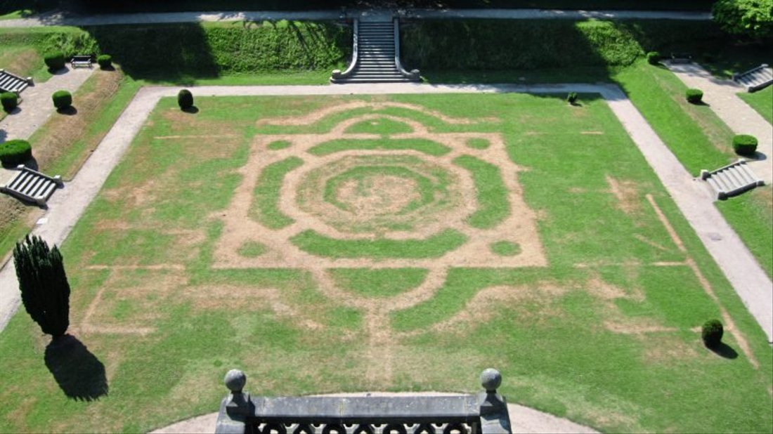
Read this article some days ago, about the findings because of the heatwave, at Gawthorpe Hall:
It´s german, but the pics are internationally understable... xD
[url=https://www.noz.de/deutschland-welt/gut-zu-wissen/artikel/1408188/dank-duerre-viktorianischer-garten-taucht-wieder-auf#gallery&0&0&1408188]Link[/ url]
I am sorry but tha linky thing doesn´t work the right way for me right now!
It´s german, but the pics are internationally understable... xD
[url=https://www.noz.de/deutschland-welt/gut-zu-wissen/artikel/1408188/dank-duerre-viktorianischer-garten-taucht-wieder-auf#gallery&0&0&1408188]Link[/ url]
I am sorry but tha linky thing doesn´t work the right way for me right now!
edit on 15 8 2018 by DerBeobachter because: (no reason given)
edit on 15 8 2018 by DerBeobachter because: (no reason
given)
a reply to: MorpheusUSA
Cool pictures , I'd be interested to see further investigation of the Oxford site , looks like a large settlement.
Cool pictures , I'd be interested to see further investigation of the Oxford site , looks like a large settlement.
originally posted by: generik
the sad part is most of these sites will just fade back into being forgotten, without any real investigation. it seems people don't want to allow them to actually dig and research the finds. seems people may not want to loose use of the land by letting them dig. and i would suspect fearful that they could in the end actually loose that land permanently from being turned into historical sites.
That is a legitimate concern. There's a reason these sites were abandoned in the past. They were no longer relevant. We can't retain, restore, or dig up every single outhouse that has ever been constructed in the past. We'd be buried in our old junk.
Just like the Internet.
a reply to: generik
These and the no doubt other pictures of the parch marks exposed this Summer mean they won't fade back into being forgotten , they are a visual reminder of what's there to be investigated.
the sad part is most of these sites will just fade back into being forgotten, without any real investigation.
These and the no doubt other pictures of the parch marks exposed this Summer mean they won't fade back into being forgotten , they are a visual reminder of what's there to be investigated.
Heatwave?
99* is hot to you guys?
Man, what Texans probably would not give to say that's the hottest it ever gets.
Sorry, had to throw my jab in there.
99* is hot to you guys?
Man, what Texans probably would not give to say that's the hottest it ever gets.
Sorry, had to throw my jab in there.
originally posted by: generik
the sad part is most of these sites will just fade back into being forgotten, without any real investigation. it seems people don't want to allow them to actually dig and research the finds. seems people may not want to loose use of the land by letting them dig. and i would suspect fearful that they could in the end actually loose that land permanently from being turned into historical sites.
I hadn't considered the following, and no offence to the good folk of the UK-- a friend recently commented on how the English are famous for digging up other country's historical sites yet leave a lot of theirs alone.
Interesting thread - history never stops teaching us.
a reply to: SlapMonkey
Well I believe the sat scans use some sort of spectography to detect changes in soils.
It might work even with some light coverage but I'm not sure.
And for sure LIDAR would uncover a bunch of things.
Well I believe the sat scans use some sort of spectography to detect changes in soils.
It might work even with some light coverage but I'm not sure.
And for sure LIDAR would uncover a bunch of things.
originally posted by: SR1TX
Heatwave?
99* is hot to you guys?
Man, what Texans probably would not give to say that's the hottest it ever gets.
Sorry, had to throw my jab in there.
Perspective, perspective. Im in Yorkshire - 53.9 degrees latitude. Or, to put another way, further North than Edmonton and Calgary. Heatwave for me begins at 17 celsius!
originally posted by: SlapMonkey
a reply to: grey580
I feel like that would be a hard place for satellite archaeology (SA) to survey, as all of the crops and flora in that area obscure visual identification most of the time.
The sands of deserts are perfect places for SA, but I doubt that it would be very fruitful to apply that method to the UK's landscape.
Now, doing LIDAR scans might be a different story altogether.
There are undoubtedly many discoveries still to be made.However, we also have to factor in that we simply re used a lot of our older sites. For example, only a tiny tiny percentage of Hadrian's Wall still exists. The rest was used for housing, mills, farms, dry stone walls, etc. This will be similar all over the country.
new topics
-
1 Billion dollars
General Entertainment: 11 minutes ago -
London Christmas Market BANS Word ‘Christmas’
Social Issues and Civil Unrest: 1 hours ago -
Marvin Gabrion's sentence commuted by Biden
US Political Madness: 2 hours ago -
Parker Solar Probe is about to Kiss the Sun
Space Exploration: 3 hours ago -
Drones On Live Beach Cam New Jersey.
Aliens and UFOs: 5 hours ago -
Christmas Dinner ??
Food and Cooking: 5 hours ago -
Merry Christmas !!
General Chit Chat: 8 hours ago
top topics
-
Merry Christmas !!
General Chit Chat: 8 hours ago, 13 flags -
Marvin Gabrion's sentence commuted by Biden
US Political Madness: 2 hours ago, 10 flags -
Christmas Dinner ??
Food and Cooking: 5 hours ago, 5 flags -
Drones On Live Beach Cam New Jersey.
Aliens and UFOs: 5 hours ago, 4 flags -
Parker Solar Probe is about to Kiss the Sun
Space Exploration: 3 hours ago, 4 flags -
London Christmas Market BANS Word ‘Christmas’
Social Issues and Civil Unrest: 1 hours ago, 4 flags -
1 Billion dollars
General Entertainment: 11 minutes ago, 0 flags
active topics
-
‘Something horrible’: Somerset pit reveals bronze age cannibalism
Ancient & Lost Civilizations • 21 • : BrucellaOrchitis -
London Christmas Market BANS Word ‘Christmas’
Social Issues and Civil Unrest • 20 • : TzarChasm -
Parker Solar Probe is about to Kiss the Sun
Space Exploration • 6 • : AdultMaleHumanUK -
1 Billion dollars
General Entertainment • 0 • : Blueracer -
President-elect TRUMP Picks MATT GAETZ for his ATTORNEY GENERAL - High Level PANIC Ensues.
2024 Elections • 143 • : WeMustCare -
Marvin Gabrion's sentence commuted by Biden
US Political Madness • 4 • : DBCowboy -
Christmas Dinner ??
Food and Cooking • 4 • : Naftalin -
Petition Calling for General Election at 564,016 and rising Fast
Political Issues • 164 • : gortex -
Well, here we go red lines crossed Biden gives the go ahead to use long range missiles
World War Three • 407 • : WeMustCare -
University looking for gender diverse kids to play with transgender dolls for research
Social Issues and Civil Unrest • 26 • : Myhandle
29


