It looks like you're using an Ad Blocker.
Please white-list or disable AboveTopSecret.com in your ad-blocking tool.
Thank you.
Some features of ATS will be disabled while you continue to use an ad-blocker.
6
share:
Well I must say, I am enjoying these years in science. We lost a planet nearly a decade ago, but somehow we have recently gained a continent. Ok, its
mostly submegred, is smaller than Australia, and its biggest surface is New Zealand!
The Geological Society published their findings, but nobody has
officiated it the way Pluto was de-listed.


Maybe this is their way of discreetly announcing they found Atlantis! Or another theory, this continent is actually a massive space colony craft, and it will soon be charged up enough to catch some thrust and rise out of the ocean. Eh well, I think I will just stick to the facts for now. Interesting conclusion, I wonder how long before the scientific and academic community will accept this, if ever?
Yahoo!
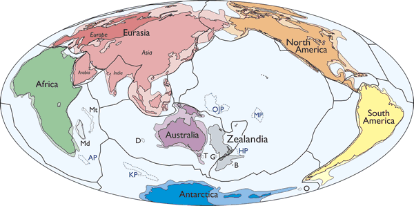
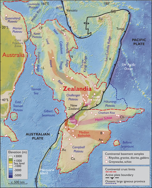
A huge landmass, mostly submerged beneath the ocean, bears all the hallmarks of a continent, according to a new study published by the Geological Society of America. You may have heard of part of it: New Zealand.
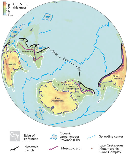
They call the continent Zealandia. At nearly 1.9 million square miles, it seems massive, but it’s two-thirds the size of the world’s (current) smallest continent, Australia. Ninety-four percent of Zealandia is underwater, with most of the other 6 percent being New Zealand. But it’s what’s beneath the surface that counts, right?
The “Zealandia” moniker was coined by geophysicist Bruce Luyendyk in 1995 (see that famous page-turner “Hypothesis for Cretaceous Rifting of East Gondwana Caused By Subducted Slab Capture” for reference.)
Luyendyk argued at the time Zealandia checked three of the four boxes to be considered its own continent. But now geologists say it checks all four: distinctive geology; a finite, defined area; crust thicker than the standard ocean floor; and elevation above the surrounding area. Zealandia apparently has it all.


Maybe this is their way of discreetly announcing they found Atlantis! Or another theory, this continent is actually a massive space colony craft, and it will soon be charged up enough to catch some thrust and rise out of the ocean. Eh well, I think I will just stick to the facts for now. Interesting conclusion, I wonder how long before the scientific and academic community will accept this, if ever?
I wonder if New Zealand will try to use this info to claim all of that territory as their own? I mean things like drilling rights, territorial waters,
etc. (For the record, I have no idea if they already claim that territory as their own or if some of it is legally classified as "international
waters.")
a reply to: enlightenedservant
Al Gore already owns all the rights to the submerged portions, and that's why he's trying to get the funding via his carbon credit trading scheme to begin teleporting water out into outer space to bring the sea level down to expose it all and cash in.
Al Gore already owns all the rights to the submerged portions, and that's why he's trying to get the funding via his carbon credit trading scheme to begin teleporting water out into outer space to bring the sea level down to expose it all and cash in.
a reply to: enlightenedservant
That is most certainly a very interesting question, and may very well work out in their favor based on what I am reading. I did a quick search and found this corresponding information as to economic zones, boundaries, etc etc..
Sorry, thats a lot of reading. So in essence, even if the shelf goes beyond their EEZ, they maintain the rights to anything on it, but cannot hold jurisdiction to living things above it which are beyond the EEZ. Now with this scientific declaration, it means New Zealand's rights to just what you mentioned have now extended much further than prior. I am going to guess if there is any protest over making this official, it will come from the Academia and scientists in Asia and Australia on behalf of their governments no doubt, in an effort not to lose potential mining and economic rights of their own under existing maritime delimitation.
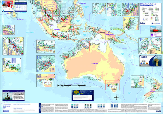
Something to keep an eye for sure. Anyone out there have any maps of potential oil reserves that have been identified within what would now be gained territory for NZ???
That is most certainly a very interesting question, and may very well work out in their favor based on what I am reading. I did a quick search and found this corresponding information as to economic zones, boundaries, etc etc..
Wikipedia
Territorial waters or a territorial sea as defined by the 1982 United Nations Convention on the Law of the Sea,[1] is a belt of coastal waters extending at most 12 nautical miles (22.2 km; 13.8 mi) from the baseline (usually the mean low-water mark) of a coastal state. The territorial sea is regarded as the sovereign territory of the state, although foreign ships (civilian) are allowed innocent passage through it, or transit passage for straits; this sovereignty also extends to the airspace over and seabed below. Adjustment of these boundaries is called, in international law, maritime delimitation.
The term "territorial waters" is also sometimes used informally to refer to any area of water over which a state has jurisdiction, including internal waters, the contiguous zone, the exclusive economic zone and potentially the continental shelf.
An exclusive economic zone extends from the outer limit of the territorial sea to a maximum of 200 nautical miles (370.4 km; 230.2 mi) from the territorial sea baseline, thus it includes the contiguous zone.[3] A coastal nation has control of all economic resources within its exclusive economic zone, including fishing, mining, oil exploration, and any pollution of those resources.
Rights over the continental shelf
Articles 77 to 81 define the rights of a country over its continental shelf.
A coastal nation has control of all resources on or under its continental shelf, living or not, but no control over any living organisms above the shelf that are beyond its exclusive economic zone. This gives it the right to conduct petroleum drilling works and lay submarine cables or pipelines in its continental shelf.
An example of this is the ongoing dispute over resources in the Arctic area, which will be decided by the exact mapping of the continental shelves.
Sorry, thats a lot of reading. So in essence, even if the shelf goes beyond their EEZ, they maintain the rights to anything on it, but cannot hold jurisdiction to living things above it which are beyond the EEZ. Now with this scientific declaration, it means New Zealand's rights to just what you mentioned have now extended much further than prior. I am going to guess if there is any protest over making this official, it will come from the Academia and scientists in Asia and Australia on behalf of their governments no doubt, in an effort not to lose potential mining and economic rights of their own under existing maritime delimitation.
Something to keep an eye for sure. Anyone out there have any maps of potential oil reserves that have been identified within what would now be gained territory for NZ???
Zealandia pfft
Just another attempt at those pesky Kiwis trying to steal us Aussies thunder, were the smallest continent and thats final!!!!
Aussie Aussie Aussie
Just another attempt at those pesky Kiwis trying to steal us Aussies thunder, were the smallest continent and thats final!!!!
Aussie Aussie Aussie
a reply to: worldstarcountry
That's exactly what I was talking about.
That's the real issue with China and its neighbors in regards to their nearby islands. And I vaguely remember something between Russia, the US, Canada, and some of the other Arctic nations about similar rights up there. So I wouldn't be surprised if we saw counter claims about this new continent.
In fact, now I'm curious to see who was backing the scientists who released this particular discovery. If you were a mining company or energy company that had a lot of business in New Zealand, a discovery like this could possibly make you a fortune. So backing research like this would be seen as an investment.
a reply to: IkNOwSTuff
Well, unlike delisting Pluto as a planet, I think making this continent official will be a much harder task as it involves billions in potential revenue gained and/or lost to various interested parties.
I found this map, but I cannot read anything because it wants me to order the full 1500MM wall chart, which is free if folded, but somehow costs 94$ to ship to me in the us, even though it will be folded up.
In any case, what it appears to me is that New Zealand would gain economic rights to underwater resources which are currently in International waters, and may even push up against Australia's border. Things like this can turn good friends into sudden rivals.

edit on 2-19-2017 by
worldstarcountry because: (no reason given)
Um, wait a minute, if it arose that'd make it the 7th continent on the planet. Duh!
Still naming Europe a "continent" is Politically inCorrect backwardsness.
Still naming Europe a "continent" is Politically inCorrect backwardsness.
edit on 19-2-2017 by IgnoranceIsntBlisss because: (no reason given)
a reply to: IkNOwSTuff
I suspect that there would probably have been a land-bridge or two somewhere in there...given how close they are.
I don't see another continent, I see an island included with Oz-land. There, your claim to fame is safe.
I suspect that there would probably have been a land-bridge or two somewhere in there...given how close they are.
I don't see another continent, I see an island included with Oz-land. There, your claim to fame is safe.
originally posted by: IkNOwSTuff
Zealandia pfft
Just another attempt at those pesky Kiwis trying to steal us Aussies thunder, were the smallest continent and thats final!!!!
Aussie Aussie Aussie
For billions of years, we have been slowly and surreptitiously sliding underneath the Australian plate. Soon we will be the foundation of Australia and then we own you.
Bwah ha ha...!
Posted earlier here
www.abovetopsecret.com...
Please add further comments to the ongoing discussion in the above linked thread.
Thanks
**Thread Closed**
www.abovetopsecret.com...
Please add further comments to the ongoing discussion in the above linked thread.
Thanks
**Thread Closed**
new topics
-
Let's start a conspiracy
General Conspiracies: 40 minutes ago -
What Joe Rogan said Vs The View
Dissecting Disinformation: 3 hours ago -
Biden's "Reckless" Decision To Escalate Russia-Ukraine War
World War Three: 4 hours ago
top topics
-
President-Elect TRUMP Picks Former Florida A.G. PAM BONDI to be U.S. Attorney General.
2024 Elections: 16 hours ago, 15 flags -
Biden's "Reckless" Decision To Escalate Russia-Ukraine War
World War Three: 4 hours ago, 15 flags -
What Joe Rogan said Vs The View
Dissecting Disinformation: 3 hours ago, 10 flags -
Inca stone masonry at Sacsayhuaman, Ollantaytambo and the Sun Temple
Ancient & Lost Civilizations: 12 hours ago, 6 flags -
Let's start a conspiracy
General Conspiracies: 40 minutes ago, 0 flags
active topics
-
-@TH3WH17ERABB17- -Q- ---TIME TO SHOW THE WORLD--- -Part- --44--
Dissecting Disinformation • 3346 • : Thoughtful3 -
Well we know Putins ICBMs won't fail in their silos
World War Three • 147 • : Oldcarpy2 -
Candidate TRUMP Now Has Crazy Judge JUAN MERCHAN After Him - The Stormy Daniels Hush-Money Case.
Political Conspiracies • 2166 • : Oldcarpy2 -
Let's start a conspiracy
General Conspiracies • 3 • : UpIsNowDown2 -
What Joe Rogan said Vs The View
Dissecting Disinformation • 11 • : CriticalStinker -
Biden's "Reckless" Decision To Escalate Russia-Ukraine War
World War Three • 58 • : Oldcarpy2 -
Putin will warn civilians in targeted areas
World War Three • 41 • : Ravenwatcher -
President-Elect TRUMP Picks Former Florida A.G. PAM BONDI to be U.S. Attorney General.
2024 Elections • 40 • : WeMustCare -
DOJ moving to wind down Trump criminal cases before he takes office
Mainstream News • 41 • : WeMustCare -
Inca stone masonry at Sacsayhuaman, Ollantaytambo and the Sun Temple
Ancient & Lost Civilizations • 6 • : Hansllune
6
