It looks like you're using an Ad Blocker.
Please white-list or disable AboveTopSecret.com in your ad-blocking tool.
Thank you.
Some features of ATS will be disabled while you continue to use an ad-blocker.
share:
originally posted by: theantediluvian
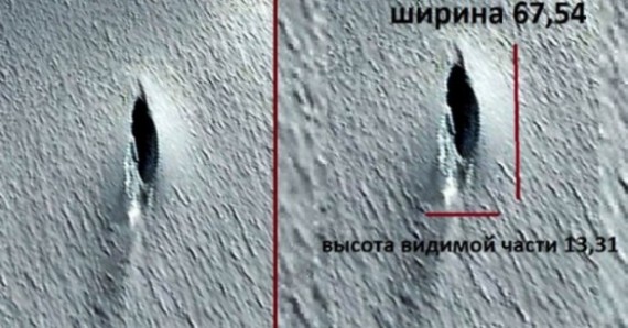
Remember the alleged 'UFO crash site' photo from a 2012 Google Earth image that made the rounds back around July after being discovered by Russian UFO researcher, Valentin Degterev? The image made it into the mainstream (albeit tabloid-y) news outlets such as The Daily Mail:
Anyone can view the object by inputting the coordinates 80°34'08.4"S 30°05'19.3"W into Google Maps.
‘I found the unique object using the online service of Google Earth in Antarctica,’ said Mr Degterev.
‘In amongst the endless ice desert, it is the most genuine UFO in its most classic shape.’
Tellingly, the object of interest is among many other cliffs and shadows, and doesn't particularly look like anything out of this world.
But Andrew Fleming from the British Antarctic Survey, told MailOnline that the object was quite clearly simply a crevasse in the ground.
'A crevasse is a lot of ice formed by differential movement of the ice,' he said.
'They can be tens of metres deep. It's one large slot, nothing unusual, but they are spectacular. It's certainly not a UFO, though.'
Well it seems that somebody has found an image purporting to be from the same site and taken a year earlier. If this information is accurate (and I'm looking for some to substantiate this) then there's something more than a simple crevice going on here.
From Mysterious Universe - Strange Vehicles Found at UFO Landing Site in Antarctica
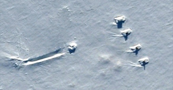
Researchers looking at previous satellite images of the same site taken in April 2011 and December 2011 found what appear to be four massive vehicles parked in the snow and pointed at the crack. In addition, these prior images show what could be the actual flying saucer with a skid mark in the snow making it look like the craft landed, possibly in an emergency.
What should we make of these earlier satellite images? While some reports identify the shapes as “tanks,” if they really are vehicles, they’re massive in size, probably around 70 feet in length. There are no tire tracks, but they could have been covered by snow or blown away.
If anyone has links to the source of the image or links to the original appearance of this image, please post. I'll see what I can find.
The first photo is not a cave or round edge of a spacecraft. It is actually the manifestation of something more nefarious. Pay close attention to the texture of the black protrusion. It has a leathery or whale skin quality to it. Also look at the hazing and blurring effect and raised feature surrounding the protrusion and then casting down to the 7 'o' clock of the image. A lot more is actually going on in the photo, but it needs a digital professional to highlight and brighten the red pigment in the photo to see the whole picture.
Same with the second image, examine the raised areas in the snow. The have the same hazing quality to them too. If the red was raised in this image, most people's minds would be blown away, if they knew what they were truly looking at. The blurring is EM interference, coupled with static water vapor, and probably some snow. Thermomagnetic plasma has an EM field and a static ion charge that produces these effects and attracts vapor and particles.
There's some bona fide Aetheric entities under them snows. I actually have a ground penetrating radar image of the Antarctic. It's pretty revealing if you know what you're looking at. Lots of Fulgurite.

edit on 12-11-2015 by trifecta because: (no reason given)
originally posted by: CharlieSpeirs
Did a reverse image search on my Veracity App and this is the earliest result I could find for the photo.
15th Aug 2012.
Haven't watched the video though.
That anomaly is actually a component in the manifestation of the Third Eye. If you want more info on this phenomenon I'll link a thread I made addressing it.
www.abovetopsecret.com...
edit on 12-11-2015 by trifecta because: (no reason given)
originally posted by: trifecta
That anomaly is actually a component in the manifestation of the Third Eye. If you want more info on this phenomenon I'll link a thread I made addressing it.
www.abovetopsecret.com...
Or you could just drag this one wildly off topic like you did the Spaceballs and ISS threads.
I'm guessing this area of Antarctica was well visited because we can see in 2014 a small weather station / village was setup there, right along the
road.
a reply to: charolais
Looking at the coordinates, which were graciously provided by a poster earlier in the thread, in Google Earth, this new image is not of the same location as the first but rather, it's actually showing some perfectly innocuous construction at Williams Field:
Looking at the coordinates, which were graciously provided by a poster earlier in the thread, in Google Earth, this new image is not of the same location as the first but rather, it's actually showing some perfectly innocuous construction at Williams Field:
Williams Field or Willy Field (ICAO: NZWD) is a United States Antarctic Program airfield in Antarctica. Williams Field consists of two snow runways located on approximately 8 meters (25 ft) of compacted snow, lying on top of 80 meters (262 ft) of ice, floating over 550 meters (1,800 ft) of water.[3] The airport, which is approximately seven miles from Ross Island, serves McMurdo Station and New Zealand’s Scott Base. Until the 2009-10 summer season, Williams was the major airfield for on-continent aircraft operations in Antarctica.
Williams Field is named in honor of Richard T. Williams, a United States Navy equipment operator who drowned when his D-8 tractor broke through the ice on January 6, 1956. Williams and other personnel were participants in the first Operation Deep Freeze, a U.S. military mission to build a permanent science research station at McMurdo Station in anticipation of the International Geophysical Year 1957–58.
edit on 2015-11-13 by theantediluvian because: (no reason given)
new topics
-
Gaetz withdraws from attorney general consideration
US Political Madness: 1 hours ago -
Bridgewater Triangle
General Chit Chat: 1 hours ago -
Is Russia Using a New Type of Beam Weapon Against Ukraine?
Weaponry: 2 hours ago -
Here is why Western leaders in NATO have zero fear of nuclear warfare. At all. Zero.
World War Three: 4 hours ago -
International Criminal Court Issues Arrest Warrant For Netanyahu
Breaking Alternative News: 4 hours ago -
racist rant, but she made the arguement to get rid of DEI
US Political Madness: 6 hours ago -
Well we know Putins ICBMs won't fail in their silos
World War Three: 6 hours ago
top topics
-
FEMA Head Admits Agency Skipped 20 Homes with Trump Signs
Mainstream News: 17 hours ago, 19 flags -
Well we know Putins ICBMs won't fail in their silos
World War Three: 6 hours ago, 12 flags -
racist rant, but she made the arguement to get rid of DEI
US Political Madness: 6 hours ago, 9 flags -
International Criminal Court Issues Arrest Warrant For Netanyahu
Breaking Alternative News: 4 hours ago, 8 flags -
Is Russia Using a New Type of Beam Weapon Against Ukraine?
Weaponry: 2 hours ago, 7 flags -
Why isn't Psychiatry involved?
Social Issues and Civil Unrest: 12 hours ago, 4 flags -
Here is why Western leaders in NATO have zero fear of nuclear warfare. At all. Zero.
World War Three: 4 hours ago, 4 flags -
Help in song interpretation
Music: 14 hours ago, 3 flags -
Gaetz withdraws from attorney general consideration
US Political Madness: 1 hours ago, 3 flags -
Bridgewater Triangle
General Chit Chat: 1 hours ago, 2 flags


