It looks like you're using an Ad Blocker.
Please white-list or disable AboveTopSecret.com in your ad-blocking tool.
Thank you.
Some features of ATS will be disabled while you continue to use an ad-blocker.
share:
originally posted by: Aarsvin
a reply to: PublicOpinion
Ceres Bright spot Albedo: 0.4
That figure is obsolete by now i believe, the bright area is much smaller than expected.
edit on 17-7-2015 by Drazzl because: (no reason
given)
a reply to: PublicOpinion
All the images you posted are from daylight side of Ceres, with various exposures to try to bring out detail in the bright spots.
Ceres' night side is practically pitch-black (although the camera could try to use the light from stars and Jupiter to try to tease out something). However, many images of Ceres have been posted where it appears as a crescent, with most of it being in darkness, and there's a chance that the bright spots are there, being just as dark as the surface around them due to not catching any sunlight.
To say that NASA doesn't want to photograph the spots on the night side because it would throw the current guesses out and present a mystery, is a conspiracy-motivated opinion. Judging by what's going on with Pluto, astronomers love a good mystery!
a reply to: wildespace
Can't argue about dark- or dayside further as I'm unfamiliar with their equipment but you do have some valid points.
On the other hand one could have presented a clear set of pictures with a complete circulation instead of pitty fragments and GIFs with missing parts. Not to mention this little problem ...
www.nasa.gov...
But you are correct, probably. And if you are up to consider G. McKinnon as part of this flow of thoughts, you might also be able to see that logics still applies. Even in rough terrain.
We, the 39% who voted for 'other', may be wrong, but I wear the following reckoning with pride. Who ceres anyway? It's nothing wrong with beeing wrong after all, innit? I want to believe(!) that ATS would be the best place to share some conspiracy-motivated opinions. But heck... nothing wrong with beeing wrong here either!
www.jpl.nasa.gov...
Cheers!
Can't argue about dark- or dayside further as I'm unfamiliar with their equipment but you do have some valid points.
On the other hand one could have presented a clear set of pictures with a complete circulation instead of pitty fragments and GIFs with missing parts. Not to mention this little problem ...
...
after experiencing an anomaly in the system that controls its orientation
...
www.nasa.gov...
But you are correct, probably. And if you are up to consider G. McKinnon as part of this flow of thoughts, you might also be able to see that logics still applies. Even in rough terrain.
We, the 39% who voted for 'other', may be wrong, but I wear the following reckoning with pride. Who ceres anyway? It's nothing wrong with beeing wrong after all, innit? I want to believe(!) that ATS would be the best place to share some conspiracy-motivated opinions. But heck... nothing wrong with beeing wrong here either!
www.jpl.nasa.gov...
Cheers!
edit on 17-7-2015 by PublicOpinion because: vote!
New report says crater is covered with haze at regular intervals. Ice deposit theory zooms up.
www.nature.com...
www.nature.com...
originally posted by: admirethedistance
Nobody ever "changed their story". There was some speculation that the bright spots may be some form of ice; That was never definitively stated as a fact.
As for the "unknown anomaly", what else are they going to call it? Just because those words seem scary and mysterious to you, doesn't mean that there's any conspiracy about it. Get over yourself.
Why in the world do you continue to post with such a rude tone after many other's have called you out for it in dozens of other threads? Do you know how much crime is on the internet? Why do you want to sound like such an antagonist? You're oddly suspicious of being some creepy person in real life. Do you go off on others on FaceBook? That is what you seem like, one of those people posting in viral threads looking for likes. Someone the Onion would make fun for you trying to be cool on an Onion thread. Just because some of us are ignorant when it comes to fact vs conspiracy theory doesn't mean we don't know how to spot a coward when we see one. To quote you, I would suggest for you to get over yourself.
OP thanks for posting an update and continuing on the discussion...
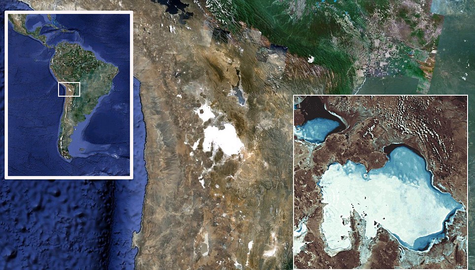
Here is a picture of Salar de Uyuni, Bolivia's massive salt flats.


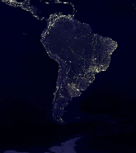
Can you see the salt fields lit up at night?
the world's largest salt flat at 10,582 square kilometers (4,086 sq mi). It is located in the Daniel Campos Province in Potosí in southwest Bolivia, near the crest of the Andes and is at an elevation of 3,656 meters (11,995 ft) above mean sea level.
Source
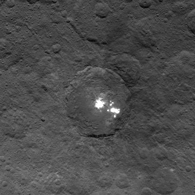
So what are we looking at on Ceres?

Occator Crater has a diameter of 91.99 kilometres (57.16 mi) Source
More from wiki:
The Salar was formed as a result of transformations between several prehistoric lakes. It is covered by a few meters of salt crust, which has an extraordinary flatness with the average altitude variations within one meter over the entire area of the Salar. The crust serves as a source of salt and covers a pool of brine, which is exceptionally rich in lithium. It contains 50 to 70% of the world's lithium reserves,[2] which is in the process of being extracted. The large area, clear skies, and the exceptional flatness of the surface make the Salar an ideal object for calibrating the altimeters of Earth observation satellites.
The Salar contains large amounts of sodium, potassium, lithium and magnesium (all in the chloride forms of NaCl, KCl, LiCl and MgCl2, respectively), as well as borax.[11] Of those, lithium is arguably most important as it is a vital component of many electric batteries. With estimated 9,000,000 tonnes (8,900,000 long tons; 9,900,000 short tons), Bolivia holds about 43% of the world's lithium reserves;[12] most of those are located in the Salar de Uyuni.
Salt flats are ideal for calibrating the distance measurement equipment of satellites because they are large, stable surfaces with strong reflection, similar to that of ice sheets. As the largest salt flat on Earth, Salar de Uyuni is especially suitable for this purpose. In the low-rain period from April to November, due to the absence of industry and its high elevation, the skies above Salar de Uyuni are very clear, and the air is dry (relative humidity is about 30%; rainfall is roughly 1 millimetre or 0.039 inches per month). It has a stable surface which is smoothed by seasonal flooding (water dissolves the salt surface and thus keeps it leveled).
As a result, the variation in the surface elevation over the 10,582-square-kilometer (4,086 sq mi) area of Salar de Uyuni is less than 1 meter (3 ft 3 in), and there are few square kilometers on Earth that are as flat. The surface reflectivity (albedo) for ultraviolet light is relatively high at 0.69 and shows variations of only a few percent during the daytime.[6] The combination of all these features makes Salar de Uyuni about five times better for satellite calibration than the surface of an ocean.[4][5][23] Using Salar de Uyuni as the target, ICESat has already achieved the short-term elevation measurement accuracy of below 2 centimeters (0.79 in)
Alien lights for a city or an Alien salt flat, regardless both are very intriguing...Strange how a salt flat has not been more firmly suggested by NASA. There must be some details I'm missing with the distance of the photos as to why it's not confirmed at this point. I'd like to know the specific details as to why it's not confirmed to be a salt flat yet.
a reply to: JimOberg
www.nature.com...
Holy moly, thanks for the update!
The phenomenon, observed by NASA’s Dawn spacecraft, suggests that the bright spots “could be providing some atmosphere in this particular region of Ceres”, says Christopher Russell, a planetary scientist at the University of California, Los Angeles.
www.nature.com...
Holy moly, thanks for the update!
a reply to: game over man
We never saw the bright spot on the darkside. Took me a while to nail this question, but Twitter finally offered a solution:
twitter.com...
We never saw the bright spot on the darkside. Took me a while to nail this question, but Twitter finally offered a solution:
Here are the brightest spots in an underexposed image to bring out details #Ceres go.nasa.gov...
twitter.com...
originally posted by: PublicOpinion
a reply to: game over man
We never saw the bright spot on the darkside. Took me a while to nail this question, but Twitter finally offered a solution:
Here are the brightest spots in an underexposed image to bring out details #Ceres go.nasa.gov...
twitter.com...
But to be clear, that picture is still on the sunlit side.
It's just a lower exposure so the sunlit surface is not as bright.
well the answer to ceres questions regarding anything potentially 'anomalous' thus far is a resounding -'hmmm. we don't know BUT it's probably...'
from nasa. we can only speculate.
also;
- you noticed that too? tiresome isn't it? predictable, and tiresome.
also;
originally posted by: game over man you continue to post with such a rude tone
- you noticed that too? tiresome isn't it? predictable, and tiresome.
originally posted by: Soylent Green Is People
But to be clear, that picture is still on the sunlit side.
It's just a lower exposure so the sunlit surface is not as bright.
Yep. And I was wrong suggesting otherwise. Would be awesome to see those bright spots on the darkside as I'm pretty sure we didn't. But... again: prove me wrong, please!
Many thanks in advance.
originally posted by: PublicOpinion
a reply to: JimOberg
The phenomenon, observed by NASA’s Dawn spacecraft, suggests that the bright spots “could be providing some atmosphere in this particular region of Ceres”, says Christopher Russell, a planetary scientist at the University of California, Los Angeles.
www.nature.com...
Holy moly, thanks for the update!
I foudn this interesting part in an article dated March 25 2015:
www.newscientist.com - Dwarf planet Ceres might have right stuff for life...
But a model of Ceres presented at the LPSC added a complication, suggesting comet-like behaviour is only possible at the dwarf planet’s poles, not the lower latitudes where the bright spot has been seen.
Timothy Titus of the US Geological Survey in Flagstaff, Arizona, presented a thermal model that considered where ice could remain stable on Ceres’s surface over the lifetime of the solar system, rather than boiling away more quickly. If Ceres is behaving like a comet, it must have ice patches that can survive for a long time until the sun’s heat reaches them as the dwarf planet moves into a warmer part of its orbit.
Titus found that long-lasting ice could only be possible in chilly latitudes above 40°. But the plumes spotted by Herschel seemed to come from nearer the equator. “The water ice is just not stable at the latitudes that the plumes are supposedly coming from,” Titus says.
So this is just some ice sublimating, well it must be a very young patch then. I'm assuming this is referring to the same spots.
edit on
24-7-2015 by jonnywhite because: (no reason given)
originally posted by: PublicOpinion
originally posted by: Soylent Green Is People
But to be clear, that picture is still on the sunlit side.
It's just a lower exposure so the sunlit surface is not as bright.
Yep. And I was wrong suggesting otherwise. Would be awesome to see those bright spots on the darkside as I'm pretty sure we didn't. But... again: prove me wrong, please!
Many thanks in advance.
NASA has confirmed the spots dim and blink out when they reach the terminator. This was figured out a long time ago--read below.
www.universetoday.com - Bright Spots on Ceres Likely Ice, Not Cryovolcanoes...
Third, — and this is also for anyone who may be thinking there is a beam or light-creating mechanism on the surface — team member Chris Russell said there is quite conclusive evidence that the spots are reflecting light, not creating light.
“We have followed the light curve into the terminator,” he said. “The spots do get darker and then go out when the terminator is reached.”
Anyway, I'm confused. They say it might be cryvolcanoes. They say it's likely ice then say maybe not. Then they say it's salt. Then they say it has haze over it. It can't be everything. They'll nail it down. Maybe they already have. I'll admit, I'm basing my thoughts only on brief excursions into it.
NOTE: "They say" is referring to the articles I read, not necessarily what NASA is saying.
edit on 24-7-2015 by jonnywhite because: (no reason
given)
a reply to: jonnywhite
Thank you for your reply, I was thinking of exactly that little GIF as I wrote this:
I can't see if the spot is going clearly into the dark or just over the equator (with this source of light in a deep crater).
Very hard to guess in this set of pictures, innit?
Thank you for your reply, I was thinking of exactly that little GIF as I wrote this:
On the other hand one could have presented a clear set of pictures with a complete circulation instead of pitty fragments and GIFs with missing parts.
I can't see if the spot is going clearly into the dark or just over the equator (with this source of light in a deep crater).
Very hard to guess in this set of pictures, innit?
originally posted by: jonnywhite
Anyway, I'm confused. They say it might be cryvolcanoes. They say it's likely ice then say maybe not. Then they say it's salt. Then they say it has haze over it. It can't be everything. They'll nail it down. Maybe they already have. I'll admit, I'm basing my thoughts only on brief excursions into it.
NOTE: "They say" is referring to the articles I read, not necessarily what NASA is saying.
Different NASA scientists have different early opinions.
There isn't enough hard data to pin down one hypothesis yet, so it isn't surprising that there are several hypotheses among the people involved in trying to determine what the spot sare.
edit on 7/25/2015 by Soylent Green Is People because: speeling
new topics
-
The daily fail trying to imply “it’s aliens”
The Gray Area: 57 minutes ago -
Swarms of tiny 'ant-like' robots lift heavy objects and navigate obstacles
Science & Technology: 2 hours ago -
NYPD Chief Jeffrey Maddrey Resigns - Forced Officers to Give Sex for Overtime Pay and Favors.
Posse Comitatus: 3 hours ago -
The Carpet Coating that Attacked the Environment
Medical Issues & Conspiracies: 7 hours ago -
Microplastics in your drinks
Medical Issues & Conspiracies: 8 hours ago
top topics
-
The Carpet Coating that Attacked the Environment
Medical Issues & Conspiracies: 7 hours ago, 11 flags -
China Working on 'Drone Mothership' Plane
Military Projects: 13 hours ago, 10 flags -
Microplastics in your drinks
Medical Issues & Conspiracies: 8 hours ago, 5 flags -
Happy Rush Day 2024 - 2112
Music: 13 hours ago, 4 flags -
NYPD Chief Jeffrey Maddrey Resigns - Forced Officers to Give Sex for Overtime Pay and Favors.
Posse Comitatus: 3 hours ago, 2 flags -
12-21-24 Usyk-Fury II
World Sports: 16 hours ago, 1 flags -
Swarms of tiny 'ant-like' robots lift heavy objects and navigate obstacles
Science & Technology: 2 hours ago, 1 flags -
The daily fail trying to imply “it’s aliens”
The Gray Area: 57 minutes ago, 1 flags
active topics
-
The daily fail trying to imply “it’s aliens”
The Gray Area • 1 • : BeyondKnowledge3 -
Microplastics in your drinks
Medical Issues & Conspiracies • 16 • : BeyondKnowledge3 -
Just spotted an unusual aircraft Melbourne Australia
Aliens and UFOs • 7 • : Cavemannick -
Swarms of tiny 'ant-like' robots lift heavy objects and navigate obstacles
Science & Technology • 2 • : BeyondKnowledge3 -
Post A Funny (T&C Friendly) Pic Part IV: The LOL awakens!
General Chit Chat • 7942 • : imitator -
An Interesting Conversation with ChatGPT
Science & Technology • 32 • : Sasquatch1111 -
Drones everywhere in New Jersey ---and Elsewhere Master Thread
Aliens and UFOs • 221 • : imitator -
Donald Trump Should Offer AMNESTY to the BIDEN FAMILY For Indicting Blackmailers-Controllers.
US Political Madness • 78 • : WeMustCare -
JOSEPH BIDEN Says Democrat Coup Leaders Forced Him to Resign the Presidency - Eff 1.20.2025.
2024 Elections • 55 • : WeMustCare -
Democrat Leader Hakeem Jeffries Promotes HATE After 2nd Attempt to Murder Trump in 2024.
US Political Madness • 41 • : WeMustCare
