It looks like you're using an Ad Blocker.
Please white-list or disable AboveTopSecret.com in your ad-blocking tool.
Thank you.
Some features of ATS will be disabled while you continue to use an ad-blocker.
share:
a reply to: mysterioustranger
Yeah, but still it is reported that ice coverage is better than the 30-year average.
Link
Not new...not unusual.
Yeah, but still it is reported that ice coverage is better than the 30-year average.
Link
I'm pretty sure it is all a part of Canada's asymmetric warfare program against the US. Like when they deported all their geese to become permanent
year round illegal aliens that crap all over everything, Justin Beiber and his crap, and of course all that anti-littering stuff that started with
crying Indian commercial back in the 70's.
It is a slow, long term warfare program. They are just that devious. Heck most of the staff here at ATS are Canadians
It is a slow, long term warfare program. They are just that devious. Heck most of the staff here at ATS are Canadians
a reply to: PeterMcFly
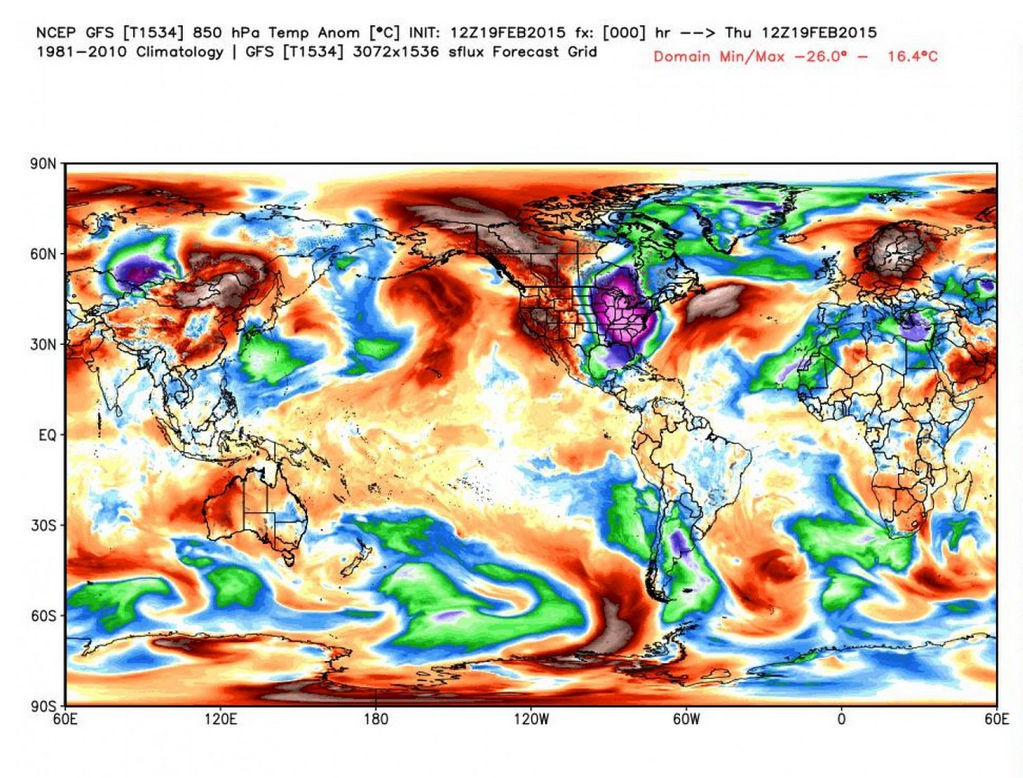
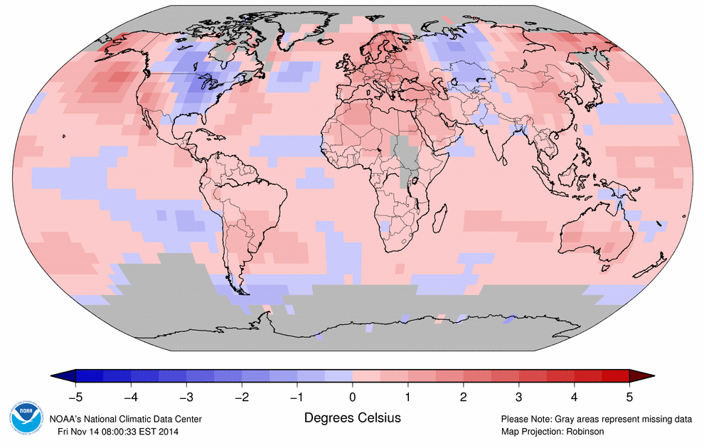
Just because it's cold in one place doesn't mean the planet as a whole isn't heating.
Link


[url=http://www.washingtonpost.com/blogs/capital-weather-gang/wp/2014/11/20/snowed-under-and-frozen-over-u-s-weather-is-off-the-rails-but-why/]Link[/u rl]
Just because it's cold in one place doesn't mean the planet as a whole isn't heating.
With essentially the same continental-scale weather pattern locked in place for most of the last two years, winter weather maps don’t have much variation: It’s red in the West, blue in the East. That pattern can be blamed on a variety of physical causes: a wavier-than-normal jet stream, hotter-than-average ocean temperatures off the Pacific Coast, melting Arctic sea ice linked to human-induced climate change, and more. Despite the persistent extreme cold in the East, North America’s still running a fever at the same rate as the rest of the globe.
Link


[url=http://www.washingtonpost.com/blogs/capital-weather-gang/wp/2014/11/20/snowed-under-and-frozen-over-u-s-weather-is-off-the-rails-but-why/]Link[/u rl]
edit on 20-2-2015 by Liquesence because: (no reason given)
originally posted by: PeterMcFly
The Great Lakes are freezing, most are covered with 9/10+ ice.
NOAA 2015-02-19
Probably caused again by the "warming"... Is there is something that cannot be caused by the "warming"?
It seems like people yet do not know what global warming is (be it fake or real).
Global warming DOES NOT mean that the planet turns into a tropical paradise or volcano.
It means that the atmosphere's heat up, causing climate change. Places get hotter, places get colder.
a reply to: PeterMcFly
Yeah..but still normal to us here...and this morning I saw two freighters head towards the Detroit River from Lake Erie up to the other Great Lakes
Yeah..but still normal to us here...and this morning I saw two freighters head towards the Detroit River from Lake Erie up to the other Great Lakes
a reply to: Kangaruex4Ewe
Live up here and took a tour on lake Superior with the wife last spring. There were still ice cubes floating around when there weren't supposed to be none. The water temp stayed low good part of the year they said. Your comment made me laugh out loud............thanks for the chuckle.
Live up here and took a tour on lake Superior with the wife last spring. There were still ice cubes floating around when there weren't supposed to be none. The water temp stayed low good part of the year they said. Your comment made me laugh out loud............thanks for the chuckle.
a reply to: Tarzan the apeman.
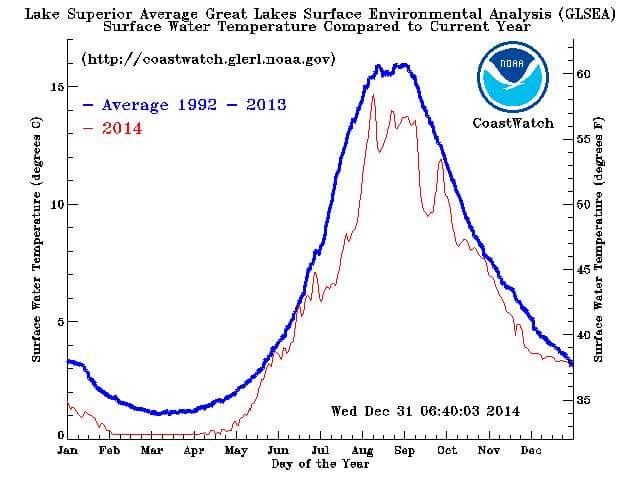
The NWS Station in Marquette released a graph of the yearly temps for Lake Superior in 2014. It was like a wild rollercoaster. That was released back in January, I believe.
Edit to add:
I was mistaken. It was NOAA.

The NWS Station in Marquette released a graph of the yearly temps for Lake Superior in 2014. It was like a wild rollercoaster. That was released back in January, I believe.
Edit to add:
I was mistaken. It was NOAA.

edit on 2/24/2015 by cmdrkeenkid because: Added additional response.
new topics
-
Ed Dowd some good news
Medical Issues & Conspiracies: 1 hours ago -
Anyone like the Scorpions?
Music: 1 hours ago -
What if this is true?
2024 Elections: 2 hours ago -
Merry-Go-Round Ride
Short Stories: 4 hours ago -
It's toast
General Chit Chat: 8 hours ago -
Man Stabbed or Cardiac arrest on Westminster Bridge, London, UK
Mainstream News: 9 hours ago -
A fix for the Trans players in sports
Social Issues and Civil Unrest: 11 hours ago
top topics
-
Petition Calling for General Election at 564,016 and rising Fast
Political Issues: 14 hours ago, 14 flags -
A fix for the Trans players in sports
Social Issues and Civil Unrest: 11 hours ago, 14 flags -
Man Stabbed or Cardiac arrest on Westminster Bridge, London, UK
Mainstream News: 9 hours ago, 7 flags -
It's toast
General Chit Chat: 8 hours ago, 7 flags -
What if this is true?
2024 Elections: 2 hours ago, 7 flags -
Merry-Go-Round Ride
Short Stories: 4 hours ago, 5 flags -
Ed Dowd some good news
Medical Issues & Conspiracies: 1 hours ago, 4 flags -
Anyone like the Scorpions?
Music: 1 hours ago, 3 flags
active topics
-
France gives Ukraine license to fire long-range missiles at Russia
World War Three • 39 • : WeMustCare -
What if this is true?
2024 Elections • 17 • : WeMustCare -
Anyone like the Scorpions?
Music • 2 • : Flyingclaydisk -
Ed Dowd some good news
Medical Issues & Conspiracies • 0 • : annonentity -
Merry-Go-Round Ride
Short Stories • 5 • : randomuser2034 -
Results of the use of the Oreshnik missile system in Dnepropetrovsk
World War Three • 217 • : worldstarcountry -
Russia Ukraine Update Thread - part 3
World War Three • 6876 • : worldstarcountry -
Petition Calling for General Election at 564,016 and rising Fast
Political Issues • 65 • : Oldcarpy2 -
It's toast
General Chit Chat • 9 • : Bluntone22 -
A fix for the Trans players in sports
Social Issues and Civil Unrest • 18 • : Tolkien
