It looks like you're using an Ad Blocker.
Please white-list or disable AboveTopSecret.com in your ad-blocking tool.
Thank you.
Some features of ATS will be disabled while you continue to use an ad-blocker.
10
share:
I have been reading many things on ATS regarding the Islamic State or QSIS as many are referring to the organization now so as to not tarnish the name
of Islam.
I have come across many opinions which are based on facts which are literally wrong.
So I have taken it upon myself to presents facts, data and maps here to illustrate the situation and provide some context.
Please just look at the information and use it to further develop your view on the situation, whatever it be.
For the first map lets have a look at the entire middle east region through the lens of the Sunni-Shia divide
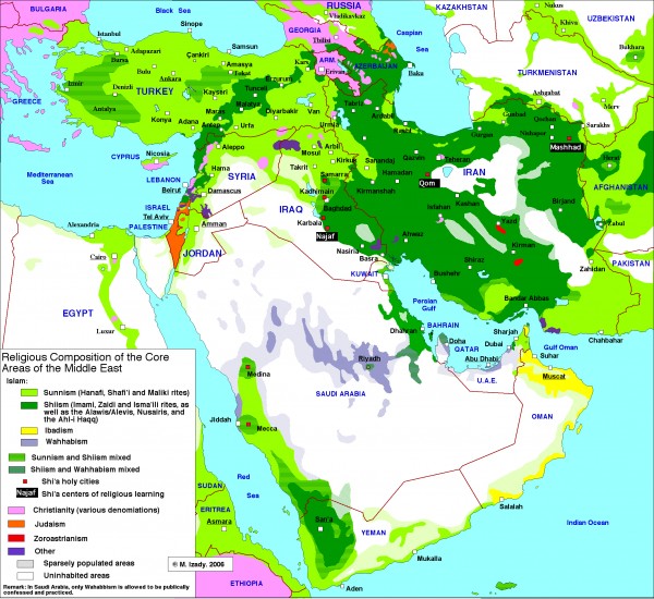
The map shows how:
- Iran is essentially a 100% Shia state.
- Southern Iraq is also almost 100% Shia.
- Western Syria + Lebanon are also very Shia dominated.
The next map is of the Territory currently controlled by the Islamic State
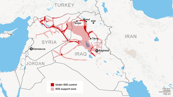
This map shows us that:
- The Qsis area of control corresponds EXACTLY to that area of Syria/Iraq which is sandwiched between the Shia dominated Iran, Southern Iraq & Western Syria/Lebanon
- Qsis area of control is largely centered on Roads due to lack of air power in a desert region.
The next map is of the oil fields situated within this region
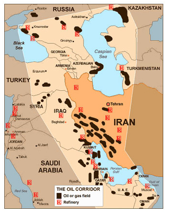
This maps shows us that:
- Qsis have seized control of essentially 100% of Syria's oil supply.
- Qsis have seized some fields in northern Iraq.
The next map is of a closeup view of the ethnic/religious makeup of Iraq.
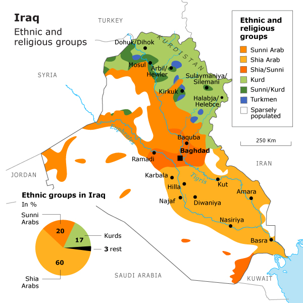
This shows us that:
- Qsis control exists almost fully, but also ONLY in Sunni Arab areas of Iraq.
- Shia & Kurds make up the vast majority of the population of Iraq.
- The Kurdish region essentially forms a barrier to Islamic state expansion.
The Next map is of a closeup view of the current situation in Syria
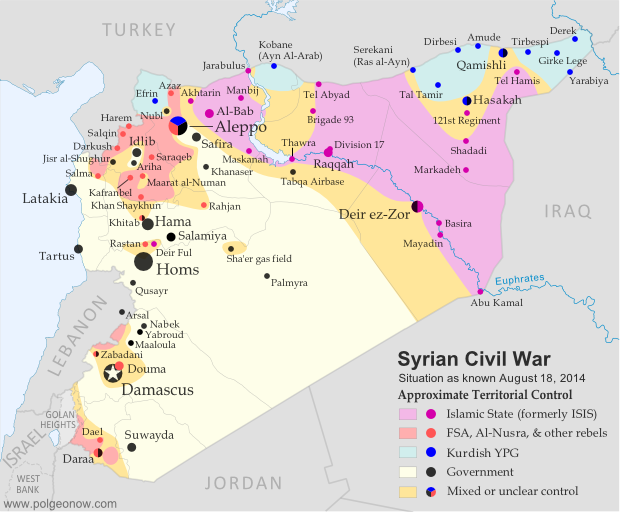
The map shows us that:
- The Syrian government forces have effective full control of western Syria, all the Shia areas and Damascus.
- The Qsis area of control exists yet again only over Sunni areas of Syria, it is bounded by the Kurds in the North, as in Iraq.
- The Qsis area in which they are strongest is Ar-Raqqa & the Entire Euphrates river basin.
The Last map is of the Kurdish region of Northern Iraq.
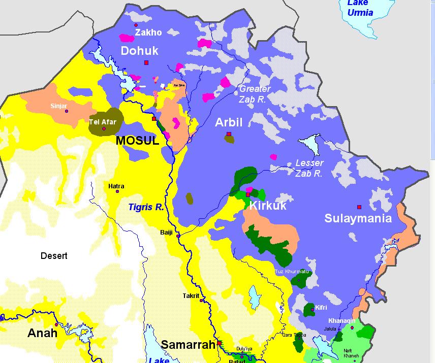
This shows us that:
- Qsis have not penetrated the Kurdish regions of either Iraq or Syria.
- Qsis find it relatively easy to control areas in which Sunni Arabs are the dominant culture.
When we take all of the maps and consolidate all of the information to form a full picture certain facts emerge.
- The Area of QSIS control corresponds exactly to the Sunni populated area of the upper Euphrates basin & the Nineveh plain in northern Iraq.
- QSIS have not been able to take or control for any period of time any Shia or Kurdish areas.
- QSIS have managed to seize the entire Oil supply of Syria & some fields in Northern Iraq.
- QSIS do not control the desert but mostly roads and rivers due to lack of air power.
- QSIS Will probably not be able to expand any further because they will not attack turkey, they will not be able to hold Shia/Kurdish areas even if they could take them due to massive hostility from the native population & they rule essentially all the Sunnis in the immediate contigous region.
Make of this what you will, I have presented facts and Maps, draw from this your own conclusions.
I have come across many opinions which are based on facts which are literally wrong.
So I have taken it upon myself to presents facts, data and maps here to illustrate the situation and provide some context.
Please just look at the information and use it to further develop your view on the situation, whatever it be.
For the first map lets have a look at the entire middle east region through the lens of the Sunni-Shia divide

The map shows how:
- Iran is essentially a 100% Shia state.
- Southern Iraq is also almost 100% Shia.
- Western Syria + Lebanon are also very Shia dominated.
The next map is of the Territory currently controlled by the Islamic State

This map shows us that:
- The Qsis area of control corresponds EXACTLY to that area of Syria/Iraq which is sandwiched between the Shia dominated Iran, Southern Iraq & Western Syria/Lebanon
- Qsis area of control is largely centered on Roads due to lack of air power in a desert region.
The next map is of the oil fields situated within this region

This maps shows us that:
- Qsis have seized control of essentially 100% of Syria's oil supply.
- Qsis have seized some fields in northern Iraq.
The next map is of a closeup view of the ethnic/religious makeup of Iraq.

This shows us that:
- Qsis control exists almost fully, but also ONLY in Sunni Arab areas of Iraq.
- Shia & Kurds make up the vast majority of the population of Iraq.
- The Kurdish region essentially forms a barrier to Islamic state expansion.
The Next map is of a closeup view of the current situation in Syria

The map shows us that:
- The Syrian government forces have effective full control of western Syria, all the Shia areas and Damascus.
- The Qsis area of control exists yet again only over Sunni areas of Syria, it is bounded by the Kurds in the North, as in Iraq.
- The Qsis area in which they are strongest is Ar-Raqqa & the Entire Euphrates river basin.
The Last map is of the Kurdish region of Northern Iraq.

This shows us that:
- Qsis have not penetrated the Kurdish regions of either Iraq or Syria.
- Qsis find it relatively easy to control areas in which Sunni Arabs are the dominant culture.
When we take all of the maps and consolidate all of the information to form a full picture certain facts emerge.
- The Area of QSIS control corresponds exactly to the Sunni populated area of the upper Euphrates basin & the Nineveh plain in northern Iraq.
- QSIS have not been able to take or control for any period of time any Shia or Kurdish areas.
- QSIS have managed to seize the entire Oil supply of Syria & some fields in Northern Iraq.
- QSIS do not control the desert but mostly roads and rivers due to lack of air power.
- QSIS Will probably not be able to expand any further because they will not attack turkey, they will not be able to hold Shia/Kurdish areas even if they could take them due to massive hostility from the native population & they rule essentially all the Sunnis in the immediate contigous region.
Make of this what you will, I have presented facts and Maps, draw from this your own conclusions.
a reply to: rusblued9217
I never realized exactly how much of that area is unpopulated... I understand it's mostly desert but that's a LOT of open space...
I never realized exactly how much of that area is unpopulated... I understand it's mostly desert but that's a LOT of open space...
Thanks for the informative post.
Hopefully they are not able to convince Shia muslims to join their cause. Taking complete control of the Tirgis and Euphrates would be very valuable for them, I would imagine.
Hopefully they are not able to convince Shia muslims to join their cause. Taking complete control of the Tirgis and Euphrates would be very valuable for them, I would imagine.
thank you for your informative non alarmist posts. i believe i was reading another thread authored by you earlier this evening about why so many
people seem to give too much credit to the CIA at the sole creator of IS, which i also do not believe it the case. although i do believe that IS has
arisen out of the power vacuum partially created by the interventionist situation that the US has played in the region for the last 2 decades.. but
now i cannot find that thread. was it deleted for being not sensationist enough? hehe ATS these days seems more interested in page views and ad
revenue
a reply to: o0oTOPCATo0o
Way too much spilled blood between the Sunnis and the Shias for them to team up in such a fashion.
Way too much spilled blood between the Sunnis and the Shias for them to team up in such a fashion.
Very interesting maps. I always wonder what the middle east would look like today if all the different sects could get along. Maybe some day they
will, I just hope it's not the radicals running the show.
a reply to: PsychoEmperor
Take note that map showing the view of the ethnic/religious makeup of Iraq may be a bit misleading because everything outside of Iraq's borders is the same color as the "sparsely populated" areas of Iraq.
BTW, great job rusblued9217!
EDIT -- nope, different colors...stupid monitor
Take note that map showing the view of the ethnic/religious makeup of Iraq may be a bit misleading because everything outside of Iraq's borders is the same color as the "sparsely populated" areas of Iraq.
BTW, great job rusblued9217!
EDIT -- nope, different colors...stupid monitor
edit on 9/4/2014 by RedParrotHead because: (no reason given)
a reply to: rusblued9217
Thanks so much for the maps, OP. I have to admit that it's confusing for me to follow events with much understanding when so much depends on the facts you've visually included. I'm grateful to have this thread as a reference point.
Thanks so much for the maps, OP. I have to admit that it's confusing for me to follow events with much understanding when so much depends on the facts you've visually included. I'm grateful to have this thread as a reference point.
And nobody asked what QSIS is?
Call Islamic State QSIS instead, says globally influential Islamic authority
Nothing like a new brand to identify yourself, how do you pronounce it though, does not flow very well.
Call Islamic State QSIS instead, says globally influential Islamic authority
Some call it Isis. Others say it's Isil. The group itself prefers Islamic State, or IS. And in the Middle East, its critics call it Da'ash.
Now Islamic State in Iraq and Syria has been given a fifth name, and perhaps its oddest: QSIS. Standing for al-Qaida Separatists in Iraq and Syria. The rebrand is an influential Islamic institution's attempt to stop the militant group smearing the reputation of Islam.
Nothing like a new brand to identify yourself, how do you pronounce it though, does not flow very well.
edit on 9/4/2014 by whatnext21 because:
(no reason given)
a reply to: rusblued9217
Is there such thing as facts in todays world that is void in someway of opinion
Is there such thing as facts in todays world that is void in someway of opinion
a reply to: rusblued9217
Sunni held areas are predominantly held by IS. However, one has to note the religious identity of this group is almost identical to the Wahhabi's in Saudi Arabia, albeit more extreme.
This in and of itself scares the hell out of the Saudis and for good reason, and that's because IS is laying claim to the true identity of Wahhabism, or the deferred promise.
Which leads them to believe an attempt at over throwing the regime in Saudi Arabia is possible.
source
Text Within the Wahhabi religious sphere, the guardians of the doctrine faced successive challenges to keep the Saudi state under the influence of the Wahhabi teachings developed by Sheikh Mohammed bin Abdel Wahhab through his letters, compilations and biography. There were efforts – sometimes individual and sometimes collective – to re- “Wahhabize” the Saudi state. But these efforts failed
edit on 4-9-2014 by Daedal because: edit
new topics
-
Dr Cambell talking about using worm meds for cancer
Medical Issues & Conspiracies: 1 hours ago -
A Question for You on the Left
Political Ideology: 3 hours ago -
Words of Wisdom from the Dear Leader - Transcribed for the World
Regional Politics: 3 hours ago -
Looks like Biden kicked off WWIII and Putin threatening nukes to retaliate
World War Three: 3 hours ago -
Watch SpaceX Starship Test Flight 6 Live - Launch Starts 4pm CST , 2200 GMT.
Space Exploration: 8 hours ago -
Watch Dramatic Moment Ukrainian Nursery Teacher Takes Out Russian Missile With Rocket Launcher
Mainstream News: 8 hours ago
top topics
-
A Question for You on the Left
Political Ideology: 3 hours ago, 12 flags -
Looks like Biden kicked off WWIII and Putin threatening nukes to retaliate
World War Three: 3 hours ago, 9 flags -
Dr Cambell talking about using worm meds for cancer
Medical Issues & Conspiracies: 1 hours ago, 6 flags -
He Had and It Has
Short Stories: 12 hours ago, 4 flags -
Words of Wisdom from the Dear Leader - Transcribed for the World
Regional Politics: 3 hours ago, 4 flags -
Morning’s Reverie
Short Stories: 15 hours ago, 3 flags -
Watch SpaceX Starship Test Flight 6 Live - Launch Starts 4pm CST , 2200 GMT.
Space Exploration: 8 hours ago, 3 flags -
Watch Dramatic Moment Ukrainian Nursery Teacher Takes Out Russian Missile With Rocket Launcher
Mainstream News: 8 hours ago, 2 flags
active topics
-
Watch Dramatic Moment Ukrainian Nursery Teacher Takes Out Russian Missile With Rocket Launcher
Mainstream News • 20 • : charlyv -
-@TH3WH17ERABB17- -Q- ---TIME TO SHOW THE WORLD--- -Part- --44--
Dissecting Disinformation • 3306 • : Thoughtful3 -
Russian ‘floating bomb’ ship packed with explosives now just 15 miles from two UK towns
Breaking Alternative News • 157 • : Oldcarpy2 -
A Question for You on the Left
Political Ideology • 10 • : RazorV66 -
Post A Funny (T&C Friendly) Pic Part IV: The LOL awakens!
General Chit Chat • 7792 • : KrustyKrab -
Dr Cambell talking about using worm meds for cancer
Medical Issues & Conspiracies • 5 • : Willzilla7476 -
He Had and It Has
Short Stories • 5 • : BingoMcGoof -
Former DOJ charged with defrauding Rep. Matt Gaetz’s family over sex-crimes investigation
Propaganda Mill • 34 • : fringeofthefringe -
President-elect TRUMP Picks MATT GAETZ for his ATTORNEY GENERAL - High Level PANIC Ensues.
2024 Elections • 101 • : fringeofthefringe -
Well, here we go red lines crossed Biden gives the go ahead to use long range missiles
World War Three • 233 • : Oldcarpy2
10
