It looks like you're using an Ad Blocker.
Please white-list or disable AboveTopSecret.com in your ad-blocking tool.
Thank you.
Some features of ATS will be disabled while you continue to use an ad-blocker.

Current airflow along Hayward Fault
page: 119
share:
From the Quake Forecaster on Twitter
sfports.wr.usgs.gov...
I have not seen it like this before..
Any thoughts?
Starting a New Thread?...Look Here First
AboveTopSecret.com takes pride in making every post count.
Please do not create minimal posts to start your new thread.
If you feel inclined to make the board aware of news, current events,
or important information from other sites;
*please post one or two paragraphs,
*a link to the entire story,
*AND your opinion, twist or take on the news item,
as a means to inspire discussion or collaborative research on your subject.
Strong frictional heating along the Hayward fault is causing convergence of the flow of air
sfports.wr.usgs.gov...
I have not seen it like this before..
Any thoughts?
Starting a New Thread?...Look Here First
AboveTopSecret.com takes pride in making every post count.
Please do not create minimal posts to start your new thread.
If you feel inclined to make the board aware of news, current events,
or important information from other sites;
*please post one or two paragraphs,
*a link to the entire story,
*AND your opinion, twist or take on the news item,
as a means to inspire discussion or collaborative research on your subject.
edit on Fri Mar 2 2012 by DontTreadOnMe because: (no reason given)
Originally posted by berkeleygal
From the Quake Forecaster on Twitter
Strong frictional heating along the Hayward fault is causing convergence of the flow of air
sfports.wr.usgs.gov...
I have not seen it like this before..
Any thoughts?
True American? Puterman? Interested in their comments.
reply to post by berkeleygal
Wow.. very interesting. I've never seen anything like it. Frictional heating? That suggests it's ready to snap any day now, by implication, no?
S&F, and I'll be monitoring this thread for.. other opinions/responses.
Wow.. very interesting. I've never seen anything like it. Frictional heating? That suggests it's ready to snap any day now, by implication, no?
S&F, and I'll be monitoring this thread for.. other opinions/responses.
First of all...that is the coolest animation ever.
Second...I have no idea what it means.
Could you please explain what it means to you?
Much obliged
Second...I have no idea what it means.
Could you please explain what it means to you?
Much obliged
Not sure what it means really.
Frictional heating may mean that Hayward is going to go but who knows.
I keep an eye on that Quake Forecaster, he is usually wrong but sometimes he is right.
We have not had any real quake action around here for months.
Frictional heating may mean that Hayward is going to go but who knows.
I keep an eye on that Quake Forecaster, he is usually wrong but sometimes he is right.
We have not had any real quake action around here for months.
Okay, I agree with others in saying that is the coolest animation I've seen before and I would have paid to know it existed while I was in the truck
and occasionally in and out of the Bay Area. Nice.
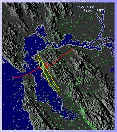
Can someone explain what about that is alarming though? It seems to show the wind patterns as I'd say I recognize from being blown around by them....I mean those are about the directions for the areas of the bay? No sarcasm..I'm really interested. Is it the compression/convergence of lines on the eastern side of the bay?
Can someone explain what about that is alarming though? It seems to show the wind patterns as I'd say I recognize from being blown around by them....I mean those are about the directions for the areas of the bay? No sarcasm..I'm really interested. Is it the compression/convergence of lines on the eastern side of the bay?
Some dude flamed me earlier about this site but, it shows that it's picking up energy from that region.
(again i don't know of the validity behind this site BUT just throwing it out there for others interested)
www.haarpstatus.com...
(again i don't know of the validity behind this site BUT just throwing it out there for others interested)
www.haarpstatus.com...
reply to post by berkeleygal
Really wish I could see this, it's not showing on my iPhone and my oldest son is up doing some homework on the main computer, so I can break in presently.
Anyway, from the linked page:
This makes me think that this is similar to stacking, wherein multiple photos are blended together to enhance detail, it's a technique amateur astronomers use to enhance blurry astronomical images.
Really wish I could see this, it's not showing on my iPhone and my oldest son is up doing some homework on the main computer, so I can break in presently.
Anyway, from the linked page:
This new visualization scheme was devloped independently by Nick Thompson who has kindly allowed us use of it. While this may initialy appear to be a time-series animation it is instead a dynamic rendering of particle streaklines. Rather than evolving through time the animation is describing the flow of the wind at a given time.
This makes me think that this is similar to stacking, wherein multiple photos are blended together to enhance detail, it's a technique amateur astronomers use to enhance blurry astronomical images.
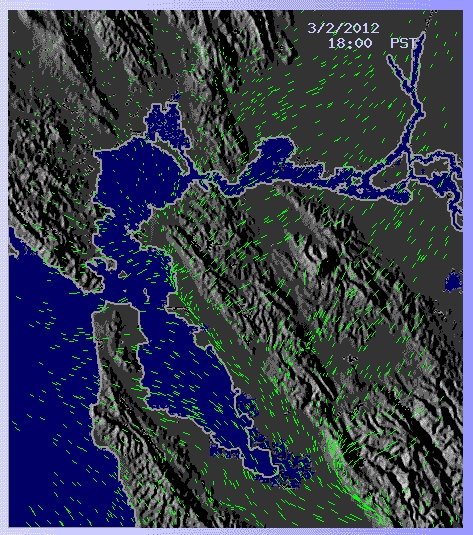
So here it is (sans animation) an on shore flow and an offshore flow converging in a line in the area of the Hayward Fault.
Still don't know if it means anything.
Originally posted by berkeleygal
So here it is (sans animation) an on shore flow and an offshore flow converging in a line in the area of the Hayward Fault.
Still don't know if it means anything.
Hello Berkeley
I'm missing the plug-in to watch the vid but judging by the picture this is
something I've never heard of. Is this normal for faults situated in a coastal area?
Fascinating to say the least.
Edit: Star & flag. I'm interested in this phenomenon as I'm near the coast in So Cal.
edit on 2-3-2012 by don rumsfeld because: (no reason
given)
Just a thought but maybe this is due to the geography of the land?
reply to post by don rumsfeld
Could be. I am going to keep watching and reloading the page each hour.
I really think this may be abnormal as the Quake Forecaster pointed it out and I think he has done enough research to the point that he thought it important.
Could be. I am going to keep watching and reloading the page each hour.
I really think this may be abnormal as the Quake Forecaster pointed it out and I think he has done enough research to the point that he thought it important.
OK gang. The "anomaly" is gone. I just updated the page for 19:00 hours and the convergence is no more.
I will post a screenshot for those of you who can't see the app.
brb
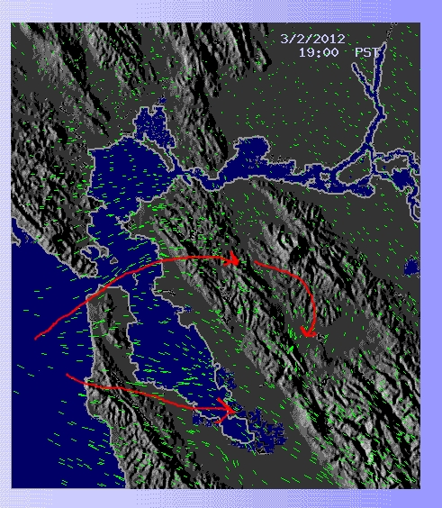
Here I show what the map was doing for at least the past 4 hours I was monitoring it.
and it was about 4 hours ago that the Quake forecaster put it up on Twitter
I will post a screenshot for those of you who can't see the app.
brb
Here I show what the map was doing for at least the past 4 hours I was monitoring it.
and it was about 4 hours ago that the Quake forecaster put it up on Twitter
edit on 2-3-2012 by berkeleygal because: (no reason given)
Well, we had a big one... BANG
I swear I felt two.
I swear I felt two.
Magnitude
4.0
Date-Time
Monday, March 05, 2012 at 13:33:12 UTC
Monday, March 05, 2012 at 05:33:12 AM at epicenter
Time of Earthquake in other Time Zones
Location
37.934°N, 122.301°W
Depth
8.8 km (5.5 miles)
Region
SAN FRANCISCO BAY AREA, CALIFORNIA
Distances
2 km (1 miles) N (1°) from El Cerrito, CA
2 km (1 miles) SE (137°) from East Richmond Heights, CA
4 km (2 miles) E (96°) from Richmond, CA
7 km (4 miles) NNW (341°) from Berkeley, CA
17 km (10 miles) NNW (337°) from Oakland, CA
Location Uncertainty
horizontal +/- 0.2 km (0.1 miles); depth +/- 0.4 km (0.2 miles)
Parameters
Nph= 81, Dmin=3 km, Rmss=0.18 sec, Gp= 25°,
M-type=regional moment magnitude (Mw), Version=5
Source
California Integrated Seismic Net:
USGS Caltech CGS UCB UCSD UNR
Event ID
nc71746761
reply to post by berkeleygal
I know two 4.0 earthquakes in San Francisco Bay area registered on my FireFox Earthquake Add-On... and two were shown on the Earthquake Mashup Map but one was removed. With your confirmation of feeling two..... seems there were two?
I know two 4.0 earthquakes in San Francisco Bay area registered on my FireFox Earthquake Add-On... and two were shown on the Earthquake Mashup Map but one was removed. With your confirmation of feeling two..... seems there were two?
edit on 3/5/2012 by dreams n chains because: added link
yes, for sure, I had just gone to bed.. The first one I thought my big cat had jumped up on the bed, then about 3 secs later, there was a huge bang
and the house shook bad.
reply to post by berkeleygal
You see what I was saying on the Quake Watch thread. I did not know anything about this one.
Can't get on to the site to see what they are showing so I will wait a bit. Getting a 503 at present
You see what I was saying on the Quake Watch thread. I did not know anything about this one.
Can't get on to the site to see what they are showing so I will wait a bit. Getting a 503 at present
Service Unavailable
The requested service is temporarily unavailable. It is either overloaded or under maintenance. Please try later.
edit on 5/3/2012 by PuterMan because: (no reason given)
reply to post by berkeleygal
You nailed that one. Hope you & your cats are ok & no pipes burst.
Good job!
Well, we had a big one... BANG I swear I felt two.
You nailed that one. Hope you & your cats are ok & no pipes burst.
Good job!
reply to post by berkeleygal
Still can't get an image. I get the page now but the Java applet is not functional. As far as I can see this site is talking about wind about wind - yay just tried it again and this time it works!! Pretty isn't it - but what the heck has this got to do with earthquakes?
The quake forecaster on twitter seems to have got his science muddled up a bit. Frictional heating takes place in the ionosphere - round about 300 km. I have no idea really as to what it actually means, but HAARP 'heats' the ionosphere so this is the same effect.
I guess it might be possible that a precursor to a fault slit may produce this since it allegedly happened before Japan (and not since which makes me think coincidence) but it would seem that the earthquake forecaster is making assumptions from which he is drawing conclusions to which he is jumping.
Um, twaddle. That air is only a few hundred metres, not kilometres. (I am assuming that the connection to this model was made by the twitter person?) No connection at all. The bandwagon of ionospheric heating must be getting pretty full with all these people jumping on it and yet not one single one, including the scientists, has been able to make a positive repeatable connection yet.
I am sure there is plenty out there including these:
Frictional Heating in Global Climate Models
From the Study of Ion Frictional Heating Events
None of this has any connection to earthquakes as far as I can see. But then I could be wrong.
Still can't get an image. I get the page now but the Java applet is not functional. As far as I can see this site is talking about wind about wind - yay just tried it again and this time it works!! Pretty isn't it - but what the heck has this got to do with earthquakes?
The quake forecaster on twitter seems to have got his science muddled up a bit. Frictional heating takes place in the ionosphere - round about 300 km. I have no idea really as to what it actually means, but HAARP 'heats' the ionosphere so this is the same effect.
I guess it might be possible that a precursor to a fault slit may produce this since it allegedly happened before Japan (and not since which makes me think coincidence) but it would seem that the earthquake forecaster is making assumptions from which he is drawing conclusions to which he is jumping.
Strong frictional heating along the Hayward fault is causing convergence of the flow of air
Um, twaddle. That air is only a few hundred metres, not kilometres. (I am assuming that the connection to this model was made by the twitter person?) No connection at all. The bandwagon of ionospheric heating must be getting pretty full with all these people jumping on it and yet not one single one, including the scientists, has been able to make a positive repeatable connection yet.
I am sure there is plenty out there including these:
Frictional Heating in Global Climate Models
From the Study of Ion Frictional Heating Events
None of this has any connection to earthquakes as far as I can see. But then I could be wrong.
new topics
-
UN Estimates Rebuilding Gaza Will Cost Up To 40 Billion Dollars
Middle East Issues: 1 hours ago -
Study Finds The More Covid Vaccine Doses You Have, the More Likely You Are to Get Covid
Medical Issues & Conspiracies: 1 hours ago -
Wounded Orangutan seen using a Plant as Medicine for the First Time
Fragile Earth: 2 hours ago -
Democratic Rep. Henry Cuellar and wife indicted on federal bribery charges
US Political Madness: 2 hours ago -
An AI-controlled fighter jet took the Air Force leader for a historic ride
Military Projects: 2 hours ago -
SEC shuts down Trump Media auditor, BF Borgers, over fraud
Mainstream News: 3 hours ago -
Farmers jailed without due process
General Conspiracies: 3 hours ago -
Poll - Catholic Support Swings to Trump By Significant Margin
2024 Elections: 7 hours ago
top topics
-
Wounded Orangutan seen using a Plant as Medicine for the First Time
Fragile Earth: 2 hours ago, 10 flags -
Farmers jailed without due process
General Conspiracies: 3 hours ago, 8 flags -
Thank you dear friends
Short Stories: 16 hours ago, 6 flags -
Democratic Rep. Henry Cuellar and wife indicted on federal bribery charges
US Political Madness: 2 hours ago, 6 flags -
Study Finds The More Covid Vaccine Doses You Have, the More Likely You Are to Get Covid
Medical Issues & Conspiracies: 1 hours ago, 6 flags -
Poll - Catholic Support Swings to Trump By Significant Margin
2024 Elections: 7 hours ago, 5 flags -
SEC shuts down Trump Media auditor, BF Borgers, over fraud
Mainstream News: 3 hours ago, 4 flags -
UN Estimates Rebuilding Gaza Will Cost Up To 40 Billion Dollars
Middle East Issues: 1 hours ago, 3 flags -
An AI-controlled fighter jet took the Air Force leader for a historic ride
Military Projects: 2 hours ago, 1 flags
active topics
-
Illegal Immigration Outlawed in Oklahoma Starting July 1
Social Issues and Civil Unrest • 51 • : YourFaceAgain -
UN Estimates Rebuilding Gaza Will Cost Up To 40 Billion Dollars
Middle East Issues • 3 • : WhitewaterSquirrel -
Those Fake Death Numbers From Hamas Out Of Gaza
Middle East Issues • 132 • : NorthOS -
Israel rejected early Hamas offer to free all civilians if IDF didn’t enter Gaza
Middle East Issues • 178 • : Ohanka -
Alien language: If we met extraterrestrials, could we talk to them?
Aliens and UFOs • 61 • : Ophiuchus1 -
Study Finds The More Covid Vaccine Doses You Have, the More Likely You Are to Get Covid
Medical Issues & Conspiracies • 8 • : EmmanuelGoldstein -
Freaky one eye website regards emerging global talent
General Conspiracies • 55 • : Degradation33 -
Candidate TRUMP Now Has Crazy Judge JUAN MERCHAN After Him - The Stormy Daniels Hush-Money Case.
Political Conspiracies • 1100 • : YourFaceAgain -
Bigger than Covid
US Political Madness • 53 • : cherokeetroy -
Poll - Catholic Support Swings to Trump By Significant Margin
2024 Elections • 20 • : Disgusted123
19