It looks like you're using an Ad Blocker.
Please white-list or disable AboveTopSecret.com in your ad-blocking tool.
Thank you.
Some features of ATS will be disabled while you continue to use an ad-blocker.

Google earth strange findings post your finds
page: 5share:
Ran across a plane I found over Quantico Marine Corp Base using Google Maps. Doing some more research I found the following
site, which has a collection of other plane activity as well as other landmarks. Plenty more sites
which have similar lists much like this thread's listing.
Plane I ran across...
Plane I ran across...
yeah, they're not photoshopped, and they're not ancient either. This coming from a Peruvian, who's driven by them several times, i can tell you
that i've seen them with my own eyes and they're just publicity, they're man made publicity and they're not that all. I hope i solved that mystery
for you guys, and sorry if i burst some of your bubbles
Originally posted by DustintheWind
Here is one at area 51 south of the hangers.

This has been discussed before on ATS. It's a munitons storage area for the aircraft tested at Groom Lake. The reason it so far from the rest of the base is so that an accidental explosion won't threaten the rest of the base.
Good find though, not many people seem familiar with that!
Tim
Anomalous Image on Google Maps
Source
Took some some screen caps from Google Earth, the first picture is some sort of reflection with a strange see-thru middle. The second picture I found right beside it on a nearby street, related lens flares?
Here is the google coordinates if needed
Lat: 52°30'40.77"N
Lon: 4°56'59.47"E
Click Images for Large Size (56k warning)


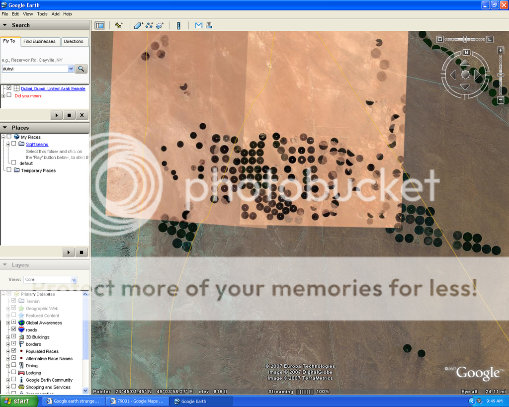
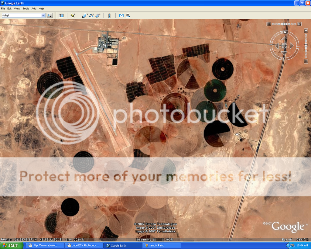
maybe there is a good explination for this, but i dont have it, hopefully someone here does. its the middle of saudi arabia
Hmmm! they look familiar! A 51!
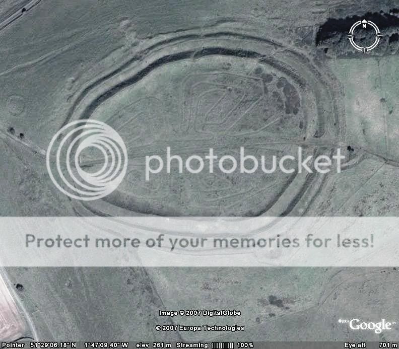
Here is one that maybe should have been at Nazka, Peru but it is the heart of England.
51 29' 07 20"N - 1 47' 09 27"W
[edit on 13-5-2007 by Havalon]
Here is one that maybe should have been at Nazka, Peru but it is the heart of England.
51 29' 07 20"N - 1 47' 09 27"W
[edit on 13-5-2007 by Havalon]
what is this in the city of moron? a ufo? or an odd shape building? and whats the light cone beam?

Hmm. Moron.. It looks old. Where did you find this? State? Country?
its in Mongolia, it has a dark old feeling to it but it is cold and dark there so...
Aman did you check this out further? Very strange.. Found a airstrip. And another building had had light from it. Zoom out it looks like a big army
base or city that looks like it was bombed.
Go north and you will see a 'lake' it to seems very unusal.
This city seems to be deserted and its in the middle of nowhere.
Go north and you will see a 'lake' it to seems very unusal.
This city seems to be deserted and its in the middle of nowhere.
Virginia Tech, Blacksburg VA
37°13'30.87"N 80°25'10.87"W
See the Skull, the Campus looks like a Skull
37°13'30.87"N 80°25'10.87"W
See the Skull, the Campus looks like a Skull
Originally posted by Havalon
Here is one that maybe should have been at Nazka, Peru but it is the heart of England.
51 29' 06 18"N - 1 47' 09 40"W
[edit on 13-5-2007 by Havalon]
reply to post by sevenkev
My husband is in the Air Force.
Just thought I would let everone know, these are target bomb ranges for bombers. There is an actual Air Force job where you go out and make those circles. You will find these "circles" all over the world, especially in areas of military bases.
[edit on 28-9-2007 by greeneyedleo]
Earth symbols
Found these on another thread. Interesting and in relative close proximity to Area 51. They've probably been posted here before although I could not find them. They look like compasses? Any ideas?
Earth Symbol 1
37°39'39.41"N 116° 1'40.28"W
Earth Symbol 2
37°28'53.03"N 116°13'46.04"W
Earth Symbol 3
37°51'20.77"N 116°49'14.99"W
Earth Symbol 4
37°51'57.05"N 116°49'18.67"W
My husband is in the Air Force.
Just thought I would let everone know, these are target bomb ranges for bombers. There is an actual Air Force job where you go out and make those circles. You will find these "circles" all over the world, especially in areas of military bases.
[edit on 28-9-2007 by greeneyedleo]
reply to post by tom goose
I think what you found with those circles are pivot sprinklers. Water is spread in a constant circle by a system that revolves around a central well or tap. The fainter circles would most likely be older plots that are no longer being watered. These sprinklers run on wheels and can cover a rather large area.
This seems to be a farm of some sort.
Originally posted by Havalon
Here is one that maybe should have been at Nazka, Peru but it is the heart of England.
51 29' 06 18"N - 1 47' 09 40"W
That is Barbury Castle, Google maps sat aerial image has no lines like that. I have found no reference to those lines anywhere.
I will ask some people who might know about them.
copy and paste these cordinates.
39 53'43.76"N 104 41'49.17"W
This will take us to the outlining section of the Denver INT airport, where there is some werid energy that is being picked up by the photos, something is showing and Ive not seen this anywhere else on google earth, but I have not scorn every inch of earth with this thing.
It looks like oil water stains.. But its covering such a large area I dont think it has to do with oil, or fuel..
I thought prehaps threw the photo it has picked up some odd energy patterns..
[edit on 29-9-2007 by zysin5]
Originally posted by zysin5
copy and paste these cordinates.
39 53'43.76"N 104 41'49.17"W
This will take us to the outlining section of the Denver INT airport, where there is some werid energy that is being picked up by the photos, something is showing and Ive not seen this anywhere else on google earth, but I have not scorn every inch of earth with this thing.
It looks like oil water stains.. But its covering such a large area I dont think it has to do with oil, or fuel..
I thought prehaps threw the photo it has picked up some odd energy patterns..
[edit on 29-9-2007 by zysin5]
Well, at first I thought it was odd too....but if you start scanning the area - even far from the airport, you can see color variousations. Possibly just diff soil colors.
For example: 39 57'12.98"N 104 49'45.07"W Up the road, but not on DIA property. Zoom out and scan around, and you will see the color variations all over
But, eh, who am I. Just my assumption
[edit on 29-9-2007 by greeneyedleo]
Originally posted by Havalon
Here is one that maybe should have been at Nazka, Peru but it is the heart of England.
51 29' 06 18"N - 1 47' 09 40"W
Here you go, it was an art installation not there anymore.
Click this link
If the link goes dead search for Barbury butterfly
new topics
-
Meadows, Giuliani Among 11 Indicted in Arizona in Latest 2020 Election Subversion Case
Mainstream News: 34 minutes ago -
Massachusetts Drag Queen Leads Young Kids in Free Palestine Chant
Social Issues and Civil Unrest: 49 minutes ago -
Weinstein's conviction overturned
Mainstream News: 2 hours ago -
Supreme Court Oral Arguments 4.25.2024 - Are PRESIDENTS IMMUNE From Later Being Prosecuted.
Above Politics: 3 hours ago -
Krystalnacht on today's most elite Universities?
Social Issues and Civil Unrest: 3 hours ago -
Chris Christie Wishes Death Upon Trump and Ramaswamy
Politicians & People: 4 hours ago -
University of Texas Instantly Shuts Down Anti Israel Protests
Education and Media: 6 hours ago -
Any one suspicious of fever promotions events, major investor Goldman Sachs card only.
The Gray Area: 8 hours ago
top topics
-
VP's Secret Service agent brawls with other agents at Andrews
Mainstream News: 17 hours ago, 11 flags -
Krystalnacht on today's most elite Universities?
Social Issues and Civil Unrest: 3 hours ago, 7 flags -
Weinstein's conviction overturned
Mainstream News: 2 hours ago, 6 flags -
Electrical tricks for saving money
Education and Media: 16 hours ago, 5 flags -
Supreme Court Oral Arguments 4.25.2024 - Are PRESIDENTS IMMUNE From Later Being Prosecuted.
Above Politics: 3 hours ago, 5 flags -
University of Texas Instantly Shuts Down Anti Israel Protests
Education and Media: 6 hours ago, 3 flags -
Massachusetts Drag Queen Leads Young Kids in Free Palestine Chant
Social Issues and Civil Unrest: 49 minutes ago, 2 flags -
Meadows, Giuliani Among 11 Indicted in Arizona in Latest 2020 Election Subversion Case
Mainstream News: 34 minutes ago, 2 flags -
Any one suspicious of fever promotions events, major investor Goldman Sachs card only.
The Gray Area: 8 hours ago, 2 flags -
God's Righteousness is Greater than Our Wrath
Religion, Faith, And Theology: 13 hours ago, 1 flags
active topics
-
Chris Christie Wishes Death Upon Trump and Ramaswamy
Politicians & People • 15 • : diaclonethunder -
Massachusetts Drag Queen Leads Young Kids in Free Palestine Chant
Social Issues and Civil Unrest • 5 • : Texastruth2 -
Candidate TRUMP Now Has Crazy Judge JUAN MERCHAN After Him - The Stormy Daniels Hush-Money Case.
Political Conspiracies • 759 • : xuenchen -
University of Texas Instantly Shuts Down Anti Israel Protests
Education and Media • 142 • : FlyersFan -
Weinstein's conviction overturned
Mainstream News • 16 • : WeMustCare -
VP's Secret Service agent brawls with other agents at Andrews
Mainstream News • 51 • : grey580 -
New whistleblower Jason Sands speaks on Twitter Spaces last night.
Aliens and UFOs • 60 • : baablacksheep1 -
Nearly 70% Of Americans Want Talks To End War In Ukraine
Political Issues • 85 • : Consvoli -
Graham Hancock being proven right all along about ancient humans in America.
Ancient & Lost Civilizations • 106 • : JonnyC555 -
Supreme Court Oral Arguments 4.25.2024 - Are PRESIDENTS IMMUNE From Later Being Prosecuted.
Above Politics • 47 • : matafuchs