It looks like you're using an Ad Blocker.
Please white-list or disable AboveTopSecret.com in your ad-blocking tool.
Thank you.
Some features of ATS will be disabled while you continue to use an ad-blocker.

Eruption and Tsunami in Tongo and American Samoa
page: 2share:
www.dailymail.co.uk...
major problems with communications
I guess we really don't know how much damage / suffering.
satellite images have revealed the devastation caused by the 'once-in-a-millennia' underwater volcanic eruption at the weekend.
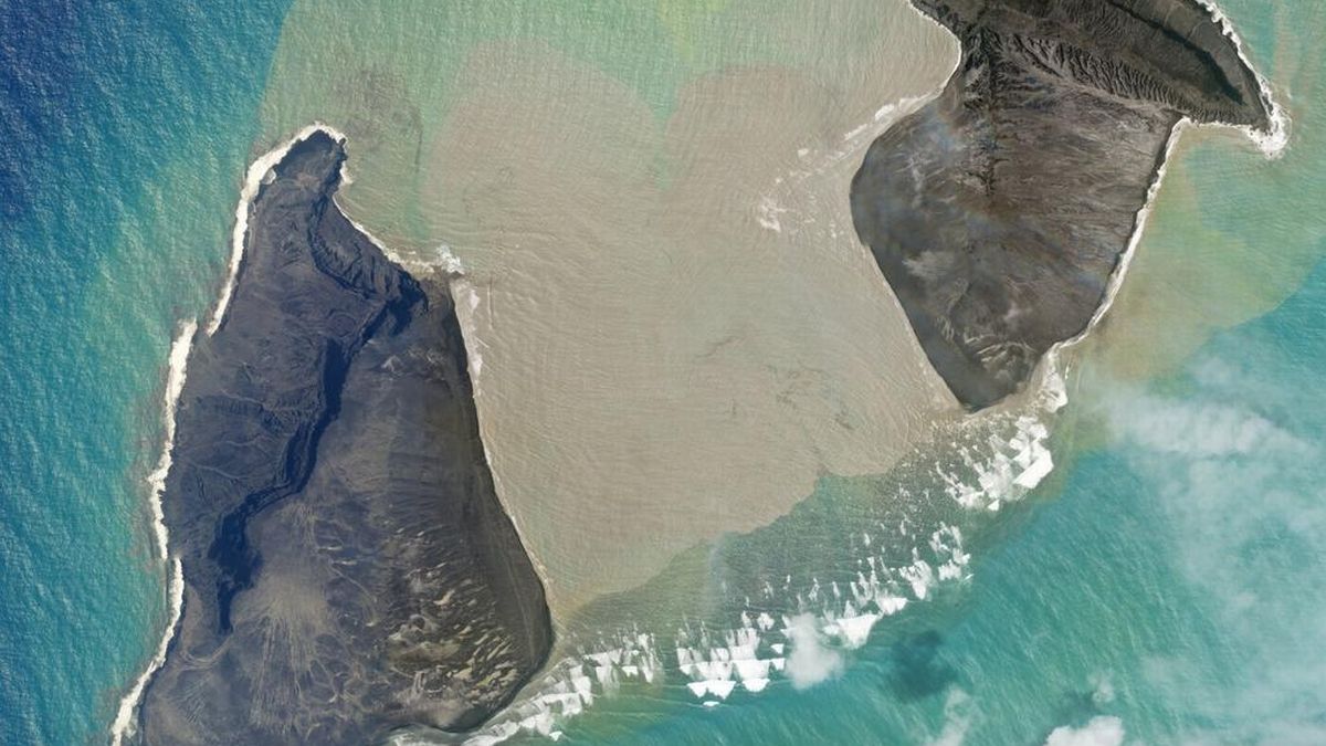
The peak of Hunga-Tonga, which has been visible above the ocean since eruptions in 2014/15 formed a new island, has been almost entirely destroyed with just a few scraps of land visible through clouds in images taken Sunday.
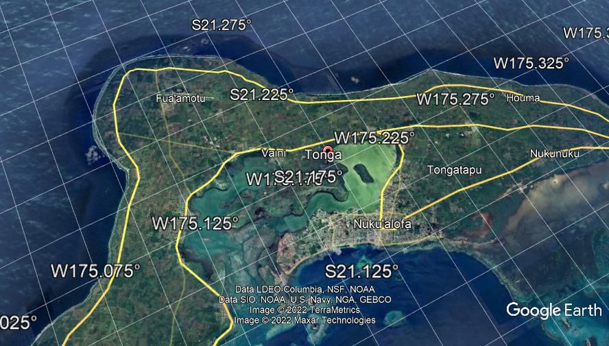
Tongatapu has also been badly damaged with water inundating the northern shoreline - facing the volcano - and water damage also visible on the southern side of the island.
An airfield in the southeastern corner of the island also shows signs of water damage, suggesting the wave was able to penetrate at least two miles inland from the coast.
Similar damage is also visible in coastal areas on the islands of Uoleva and Nomuka, with lesser damage to the coastal areas on Uiha island. Ash deposits are visible on all islands, as debris from the eruption rained form the sky.
major problems with communications
I guess we really don't know how much damage / suffering.
These don't even look like the same island, the 100,000 population center is just gone? That was a 45 to 70 foot ridge across there on the north
side.
Mods please correct if this is wrong.
Before
After
Mods please correct if this is wrong.
Before
After
edit on 17-1-2022 by fromunclexcommunicate because: (no reason given)
a reply to: fromunclexcommunicateThe top picture appears to be a populated island, I am pretty confident that the second I have
seen from other pictures, it is the after of a before-and-after of the volcano itself, which is 40? miles from the populated islands. It's been a day
or so and we have little idea, very scary, but this is not a before and after of the populated island, pray.
a reply to: fromunclexcommunicate
Those two islands that you have in the pictures are two different islands. The bottom one had a volcano05im on it before that picture and the top one still looks like that.
Those two islands that you have in the pictures are two different islands. The bottom one had a volcano05im on it before that picture and the top one still looks like that.
a reply to: Guyfriday
The Hunga Tonga volcano 40 miles to the north split which is no surprise.
Looks like they will get the ash cleared off the Airport runway in populated Tonga fairly quickly so they can bring in aid and water filters. Apparently a major undersea cable was destroyed so they will be relying on satellite links for a while.
edit on 18-1-2022 by
fromunclexcommunicate because: (no reason given)
a reply to: japhrimu
I saw a very compelling analysis of the video enlarged and slowed down. It definitely looked like a meteor impact caused the explosion. Then shills jumped on saying it was a missile but they were quickly debunked as a missile would not have showed up on video. What it looked like was a large object began to explode and break up( a sonic boom puff of smoke) and then a larger video image then hitting the water at the sight of the explosion.
What struck me as odd was we had reports of the explosion and then later they said to have video of a prior explosion which wasn't reported until later.
And then coincidentally they ran a story yesterday of how they're tracking a large asteroid as it makes a close pass by of Earth.
I think they don't want to admit they aren't nearly as able to spot and predict these impacts and can't track them and give any warning. They're now trying to make up asteroids they claim to know about and want us to believe they can give us some advanced warning. They can't.
www.france24.com...
I think we still don't know how bad it was for those poor people
Two New Zealand navy vessels will arrive in Tonga on Friday, carrying much-needed water and other supplies for the Pacific island nation reeling from a volcanic eruption and tsunami, and largely cut off from the outside world.
Hundreds of homes in Tonga's smaller outer islands have been destroyed, and at least three people were killed after Saturday's huge eruption triggered tsunami waves, which rolled over the islands causing what the government has called an unprecedented disaster.
With its airport smothered under a layer of volcanic ash and communications badly hampered by the severing of an undersea cable, information on the scale of the devastation has mostly come from reconnaissance aircraft.
"For the people of Tonga, we're heading their way now with a whole lot of water," Simon Griffiths, captain of the HMNZS Aotearoa, said in a release.
I think we still don't know how bad it was for those poor people
edit on 01032020 by ElGoobero because: add content
originally posted by: Dutchowl
a reply to: japhrimu
What struck me as odd was we had reports of the explosion and then later they said to have video of a prior explosion which wasn't reported until later.
And then coincidentally they ran a story yesterday of how they're tracking a large asteroid as it makes a close pass by of Earth.
I think they don't want to admit they aren't nearly as able to spot and predict these impacts and can't track them and give any warning. They're now trying to make up asteroids they claim to know about and want us to believe they can give us some advanced warning. They can't.
very interesting point.
I wonder if we are going through some asteroid belt and will see more of this.
uk.news.yahoo.com...
hopefully no further volcanic action
hoping for a good quick recovery
More than 80 percent of the archipelago's population of 100,000 have been impacted by the disaster, the United Nations has estimated, and initial assessments indicate an urgent need for drinking water.
The first smattering of images to emerge from Tonga's capital Nuku'alofa show ashen buildings, toppled walls and streets littered with boulders, tree trunks and other debris.
Tongans worked for days at the airport trying to clear the runway of ash so that much-needed aid could arrive.
The work was painfully slow, with only a few hundred metres being cleared each day.
hopefully no further volcanic action
hoping for a good quick recovery
a reply to: fromunclexcommunicate
Please getyour facts straight before posting nonsense . there is no population centre missing. Hunga Tonga was a previously active volcanic island with no inhabitants
Hunga TONGA eruption
Please getyour facts straight before posting nonsense . there is no population centre missing. Hunga Tonga was a previously active volcanic island with no inhabitants
Hunga TONGA eruption
Tonga event resulted in huge amount of water vapor going into the atmosphere
arstechnica.com...
unknown what the effect will be of all this water vapor in the atmosphere. probly not helpful.
arstechnica.com...
Compared to normal background levels of stratospheric water vapor, these radiosondes were registering 580 times as much water even two days after the eruption, after the plume had some time to spread out.
There was so much there that it still stood out as the plume drifted over South America. The researchers were able to track it for a total of six weeks, following it as it spread out while circling the Earth twice. Using some of these readings, the researchers estimated the total volume of the water vapor plume and then used the levels of water present to come up with a total amount of water put into the stratosphere by the eruption.
They came up with 50 billion kilograms. And that's a low estimate, because, as mentioned above, there was still water above the altitudes where some of the measurements stopped.
unknown what the effect will be of all this water vapor in the atmosphere. probly not helpful.
edit on 01032020 by ElGoobero because: clarify
another Tonga event
www.usatoday.com...
hopefully won't be as bad as the previous one
anyone with info on?
www.usatoday.com...
A powerful underwater earthquake struck Friday off Tonga in the southern Pacific, prompting authorities to issue a tsunami advisory.
The U.S. Geological Survey said the magnitude 7.3 quake was centered 132 miles east-southeast of Neiafu, Tonga, at a depth of 24.8 kilometers (15 miles). It predicted strong shaking but said the probability of serious damage or casualties was small.
The U.S. Tsunami Warning System issued a tsunami advisory, which is one step below a tsunami warning.
hopefully won't be as bad as the previous one
anyone with info on?
-
edit on 11/11/2022 by Creep Thumper because: (no reason given)
originally posted by: Creep Thumper
The tsunami was all of one centimeter, so 👎🏻 to the OP for trying to hype something that wasn't.
the OP was for the original event in January
this post was an update for today's event
didn't want to start a new thread unecessarily
new topics
-
StormyD Accused of Falsification of Business Records to Hide Money From Trump
US Political Madness: 3 hours ago -
Judge Postpones Trump Classified Docs Trial INDEFINITELY
US Political Madness: 5 hours ago -
To all ATS members of Faith - Prayer request
Religion, Faith, And Theology: 8 hours ago -
Don’t Obstruct the Leftist Implosion
US Political Madness: 9 hours ago -
NASA Black Hole Visualization - Go Beyond the Brink
Space Exploration: 9 hours ago
top topics
-
Don’t Obstruct the Leftist Implosion
US Political Madness: 9 hours ago, 26 flags -
Judge Postpones Trump Classified Docs Trial INDEFINITELY
US Political Madness: 5 hours ago, 25 flags -
Trump supporters training in the HILLS!!!!
US Political Madness: 16 hours ago, 18 flags -
StormyD Accused of Falsification of Business Records to Hide Money From Trump
US Political Madness: 3 hours ago, 13 flags -
To all ATS members of Faith - Prayer request
Religion, Faith, And Theology: 8 hours ago, 13 flags -
Chinese scientists create new mutant Ebola strain with horror eye symptoms
Breaking Alternative News: 13 hours ago, 10 flags -
Russia police launch major manhunt after troops massacred by comrade in occupied Ukraine
Other Current Events: 12 hours ago, 6 flags -
Social Security projected to cut benefits in 2035 barring a fix
Global Meltdown: 15 hours ago, 6 flags -
NASA Black Hole Visualization - Go Beyond the Brink
Space Exploration: 9 hours ago, 4 flags -
Is the move to greenwashing solar and wind power set up for money laundering.
The Gray Area: 16 hours ago, 2 flags
active topics
-
Israeli strikes on southern Gaza city of Rafah kill 22, mostly children, as US advances aid package
Middle East Issues • 176 • : SpinTop -
Don’t Obstruct the Leftist Implosion
US Political Madness • 22 • : fringeofthefringe -
-@TH3WH17ERABB17- -Q- ---TIME TO SHOW THE WORLD--- -Part- --44--
Dissecting Disinformation • 862 • : Justoneman -
Candidate TRUMP Now Has Crazy Judge JUAN MERCHAN After Him - The Stormy Daniels Hush-Money Case.
Political Conspiracies • 1409 • : Justoneman -
Trump supporters training in the HILLS!!!!
US Political Madness • 73 • : Justoneman -
Trump legal cases are falling apart at break neck speeds
US Political Madness • 81 • : Deidie -
Israel rejected early Hamas offer to free all civilians if IDF didn’t enter Gaza
Middle East Issues • 198 • : NorthOS -
Judge Postpones Trump Classified Docs Trial INDEFINITELY
US Political Madness • 29 • : WeMustCare -
Big Storms
Fragile Earth • 33 • : lilzazz -
To all ATS members of Faith - Prayer request
Religion, Faith, And Theology • 23 • : Albone