It looks like you're using an Ad Blocker.
Please white-list or disable AboveTopSecret.com in your ad-blocking tool.
Thank you.
Some features of ATS will be disabled while you continue to use an ad-blocker.

One curious google earth location
page: 17
share:
Please take this with a grain of salt, as it is more of a curiosity then it is a legitimate proof of anything.
I was scrolling through google earth just messing around when I came across this...
If anyone has any information on what this is or any kind of idea what it could be, I'd appreciate it.
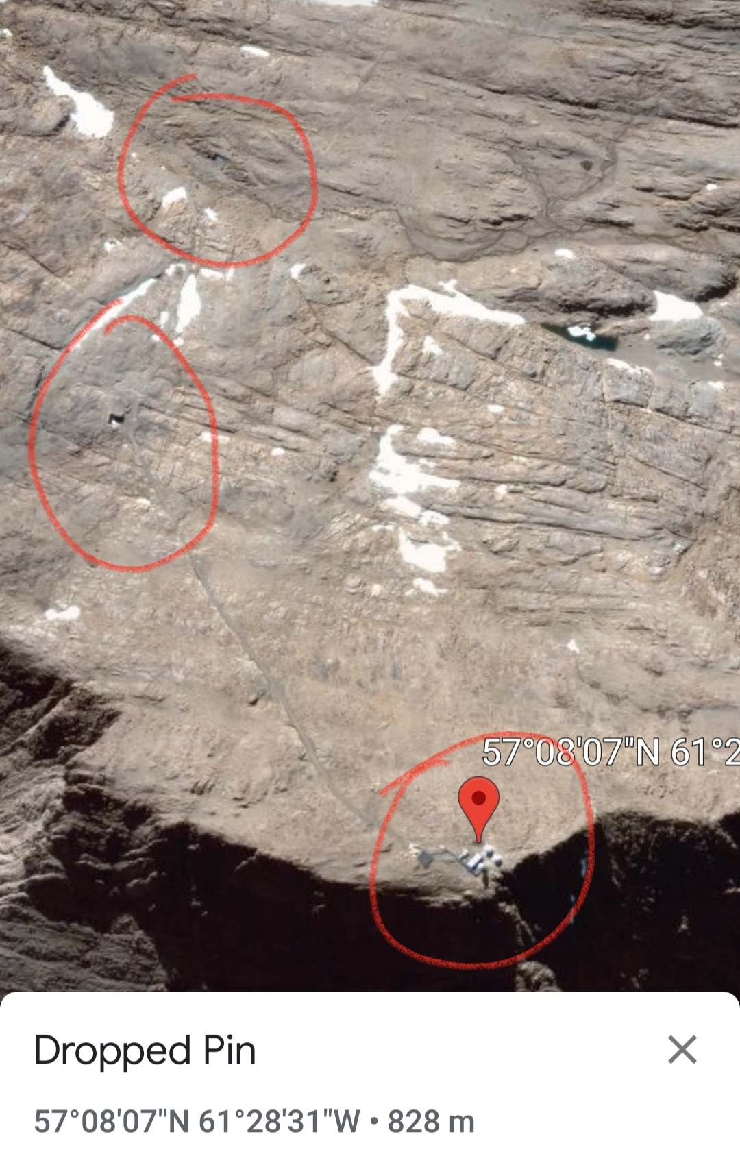
It looks like some kind of radar dishs and silos of some kind but what intrigued me was the roadways that led up off to the left seem to lead to what look like hanger doors that lead underground.
I was scrolling through google earth just messing around when I came across this...
If anyone has any information on what this is or any kind of idea what it could be, I'd appreciate it.
It looks like some kind of radar dishs and silos of some kind but what intrigued me was the roadways that led up off to the left seem to lead to what look like hanger doors that lead underground.
originally posted by: BadBoYeed
acnnro.ca... reply to: kiliker30
Probably a part of the Canadian network of research operators
Interesting. There has to be some kind of paper trail to the construction of this facility if it is a research organization, no?
Cape
Kiglapait Short Range Radar Site
North Warning System | The DEWLine
Strategic Air Defense Radars
North Warning System | The DEWLine
Strategic Air Defense Radars
Cape Kiglapait Short Range Radar Site is a Royal Canadian Air Force Short Range Radar Site located in the Kiglapait Mountains of Labrador, 268 miles north of CFB Goose Bay, Newfoundland and Labrador.
Year built: August 1992
Built by: Royal Canadian Air Force
The facility contains a Short Range AN/FPS-124 doppler airborne target surveillance radar that was installed in August 1992 as part of the North Warning System. The site (LAB-3) also consists of radar towers, communications facility, and storage and tunnel connected buildings for personnel.
en.wikipedia.org...
AN/FPS-124 is a gap filler radar for the North Warning System. The radar is a high-reliability, unattended and easily maintained short-range radar designed to operate in conjunction with the AN/FPS-117 long-range surveillance radars in the upgraded North Warning System. The radars can detect and track small radar cross-section, low flying targets, and are to be particularly effective in detecting cruise missile penetration of US and Canadian airspace.
FPS-124 uses a cylindrical phased-array antenne operating in L-Band that is approximately 12 ft (3.66 m) tall with a diameter of 5 ft (1.25 m). The electronics for the transmitter/controller are located inside the cylindrical assembly. It is cooled by 11 fans, which are the only moving parts in the system. A total of 39 units have been produced.
www.radartutorial.eu...
edit on 4.1.2020 by Murgatroid because: felt like it...
a reply to: Murgatroid
Thanks buddy that's the info I was looking for.
Unfortunately there is no photos of this specific facility anywhere on the internet I could find. Never the less, very interesting that it's an early warning system.
Thanks buddy that's the info I was looking for.
Unfortunately there is no photos of this specific facility anywhere on the internet I could find. Never the less, very interesting that it's an early warning system.
originally posted by: kiliker30
Please take this with a grain of salt, as it is more of a curiosity then it is a legitimate proof of anything.
I was scrolling through google earth just messing around when I came across this...
If anyone has any information on what this is or any kind of idea what it could be, I'd appreciate it.
It looks like some kind of radar dishs and silos of some kind but what intrigued me was the roadways that led up off to the left seem to lead to what look like hanger doors that lead underground.
The cardinal rule when you post something interesting off Google Earth, etc. is to POST THE COORDINATES!
Rather than having to manually input the coordinates from a picture.
57°08'07"N, 61°28'31"W or 57.135278°, -61.475278°
ETA: looks like a remote comm site, with radomes, helicopter landing pad, etc. I bet there is a Snowcat in what looks like a underground entrance. If you follow the trail down to the coast, there are what appear to be fuel tanks with another helicopter pad.
57.107613°, -61.386539°
edit on 3-4-2020 by FosterVS because: (no reason given)
new topics
-
4/27/24 New Jersey Earthquake
Fragile Earth: 5 hours ago -
Fun with extreme paints
Interesting Websites: 6 hours ago -
CIA is alleged to be operat social media troll frms in Kyiv
ATS Skunk Works: 7 hours ago -
Rainbow : Stargazer
Music: 8 hours ago -
I sleep no more.
Philosophy and Metaphysics: 11 hours ago -
Canada caught red-handed manipulating live weather data and make it warmer
Fragile Earth: 11 hours ago
top topics
-
Canada caught red-handed manipulating live weather data and make it warmer
Fragile Earth: 11 hours ago, 16 flags -
Why Files Our Alien Overlords | How We Secretly Serve The Tall Whites
Aliens and UFOs: 12 hours ago, 11 flags -
Curse of King Tuts Tomb Solved
Ancient & Lost Civilizations: 13 hours ago, 9 flags -
CIA is alleged to be operat social media troll frms in Kyiv
ATS Skunk Works: 7 hours ago, 6 flags -
4/27/24 New Jersey Earthquake
Fragile Earth: 5 hours ago, 6 flags -
What allies does Trump have in the world?
ATS Skunk Works: 13 hours ago, 5 flags -
I sleep no more.
Philosophy and Metaphysics: 11 hours ago, 4 flags -
Fun with extreme paints
Interesting Websites: 6 hours ago, 2 flags -
Rainbow : Stargazer
Music: 8 hours ago, 1 flags
active topics
-
University of Texas Instantly Shuts Down Anti Israel Protests
Education and Media • 360 • : CriticalStinker -
Blast from the past: ATS Review Podcast, 2006: With All Three Amigos
Member PODcasts • 2 • : Dalamax -
I sleep no more.
Philosophy and Metaphysics • 14 • : BrotherKinsMan -
4/27/24 New Jersey Earthquake
Fragile Earth • 4 • : LuciusDriftwood -
Ireland VS Globalists
Social Issues and Civil Unrest • 14 • : covent -
Gov Kristi Noem Shot and Killed "Less Than Worthless Dog" and a 'Smelly Goat
2024 Elections • 92 • : cherokeetroy -
Today I am 8
Members • 21 • : randomuser2034 -
Big Storms
Fragile Earth • 19 • : lilzazz -
George Knapp AMA on DI
Area 51 and other Facilities • 40 • : TheDiscoKing -
Silent Moments --In Memory of Beloved Member TDDA
Short Stories • 76 • : RAY1990
7