It looks like you're using an Ad Blocker.
Please white-list or disable AboveTopSecret.com in your ad-blocking tool.
Thank you.
Some features of ATS will be disabled while you continue to use an ad-blocker.

Proof Of Hollow Earth Found: "Two doctors volunteer to STAY with children trapped in Thai cave for
page: 8share:
You know, I don't fault the coach...now. Yes, it was probably a dumb mistake initially, but he didn't run away. He stayed with the boys. He will
fault himself for the rest of his life for his mistake, but he's made good on it. And, for better or worse, he'll be the last one out.
So, at this point, people can say what they will. The coach isn't my hero, but he's not a coward either, and he's owned up to the situation.
That is all.
So, at this point, people can say what they will. The coach isn't my hero, but he's not a coward either, and he's owned up to the situation.
That is all.
originally posted by: solids0be
a reply to: Butterfinger How is it misleading? Did you even read the whole post?
I agree. Totally misleading. How in the world is 2 doctors volunteering to help a group of kids proof that the Earth is hollow?
originally posted by: randyvs
They should try getting the coach out
first. Take a little off the learning curve.
Who cares if his dumb ass sinks. Turn
him over to the parents. Let him explain it
all.
25-year-old football coach
just a kid too really, everyone makes mistakes, just lucky ours have not been as severe.
Here is an update. I’m not sure if anyone is even still following this but I ran across this article and thought I would share it. So far so good
amazingly. They rescued four boys today with the remaining five boys presumably getting out of there tomorrow. They took the healthiest boys first
saving the weakest ones for tomorrow. The Thi government’s consensus on this was that the divers could practice first on the healthier boy’s to
hone their skills and that would also give the weaker boys time to eat and gain some strength. There is a good short video in this article.
SOURCE
SOURCE
a reply to: Protricity2k
Yeah the site saturndeathcult.com fills in a lot of missing pieces. Wealth of plausible info there that matches up with your post.
Yeah the site saturndeathcult.com fills in a lot of missing pieces. Wealth of plausible info there that matches up with your post.
originally posted by: bobs_uruncle
a reply to: solids0be
If the earth is hollow, where is the mass that creates gravity? I could ask the same question about a flat earth lol.
Cheers - Dave
Earth doesn't need to be 100% hollow. Most of the mass that gives gravity is the dense iron-nickel core and lithium mantle. The crust of the Earth still goes down 10 to 30 km. Now an office floor is about 2.5 meters high. So you have a distance 10,000 to 30,000 meters that could have tunnels, passageways and cave going down. so that's a distance equivalent to 400 to 1200 office floors down.
The deepest man-made mines go down 3.9km. The deepest natural cave is the Krubera cave At 2,197 meters (7,208 feet) the Krubera cave is the deepest on Earth. Located in the Arabika Massif, of the Western Caucasus in Abkhazia, Georgia, it also extends for 13.432 kilometers (8,346 miles.)
It could be possible that there are deeper caves, since there are deep thermal vents that release hot water around fault lines.
The Earth cannot be hollow because everyone knows it is flat.......
Okay, i found something interesting in Google Earth while exploring Antarctica..
I cant explain this, I've seen what looks like trees, a river, mountains, clouds in the middle of nowhere..
The sattelite photo doesn't even make sense.
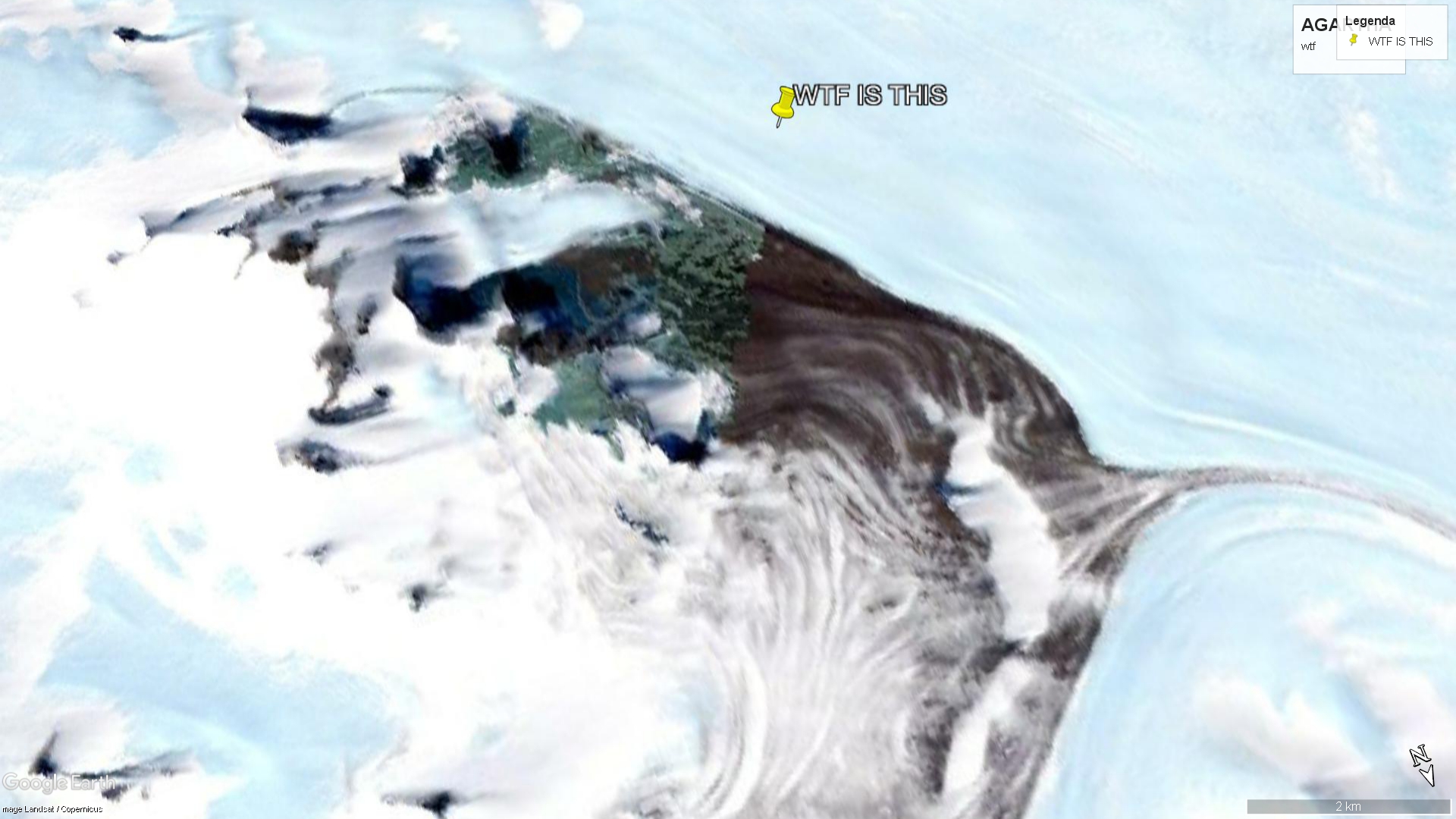
The coordinates are: 71°42'58.77"S, 35°41'13.93"E
2009 sattelite picture
Coul'd it be Agartha, the wonderland? See for yourselves.
I cant explain this, I've seen what looks like trees, a river, mountains, clouds in the middle of nowhere..
The sattelite photo doesn't even make sense.
The coordinates are: 71°42'58.77"S, 35°41'13.93"E
2009 sattelite picture
Coul'd it be Agartha, the wonderland? See for yourselves.
nice catch, I can't quite see what we're looking at. Probably a snow-covered mountain but still, a very interesting image.
If you rotate the pic, it looks like a series of waterfalls. I can't upload right now.
^
Do you think it looks green? I think so, but wanted to ask what others are seeing.
Also interesting that if you go back for images of later years, it was more colorful, until recent years it became more black / colorless.
well this thread seems all but dead lol but I thought the above post was so interesting that I made a quick video about it.
my vid on my (non-monetized) channel, goes through all the different satellite images of that same spot, on Google Earth (going from now back to 1984). The spot is more colorful, the further back in time you look. Modern images are all grey, but older pics show blue and green:
my vid on my (non-monetized) channel, goes through all the different satellite images of that same spot, on Google Earth (going from now back to 1984). The spot is more colorful, the further back in time you look. Modern images are all grey, but older pics show blue and green:
a reply to: peacefulpete
Go with the newer pictures since they are taken using better tech. The whole place looks like a mountain range with glazier near it, and some cloud cover over it. There's nothing there.
Go with the newer pictures since they are taken using better tech. The whole place looks like a mountain range with glazier near it, and some cloud cover over it. There's nothing there.
originally posted by: Guyfriday
a reply to: peacefulpete
Go with the newer pictures since they are taken using better tech. The whole place looks like a mountain range with glazier near it, and some cloud cover over it. There's nothing there.
The image sharpness doesn't seem to improve over time. Only the colors change, becoming all grey in modern images. Which could be nothing more than Google deliberately turning it grey.
Or maybe the area actually became more grey over time.
Either way, the earlier images might actually be accurate in its colors.
If you don't want to check my vid then you can check in Google Earth.
What you're seeing there are the Queen Fabiola mountains, and the range acts as a barrier to the flow of ice and glaciers around it, so a lot of the
ground is ice free some of the time. The patterns you can see are the flowlines of those glaciers around the mountains.
Many satellite imaging devices eg the early Landsat ones that combine various spectra in one image, had a lot of problems dealing with all the white glare and you quite often get greens and pinks and stripes as a result.
Here's an early Landsat one as an example:
ims.cr.usgs.gov...
It'd also not true that all modern ones are grey - here's a Landsat 8 image showing, and explaining, a deep blue colour to some of the ice
www.usgs.gov...
Try earthexplorer.usgs.gov... to get a variety of satellite sources of the region.
a reply to: OneBigMonkeyToo
Thanks, I'll check out ur links. I'm not really interested in arguing about the oddness of the image that I posted about. I'm really only saying that it's hard to see clearly, and that it's a confusing image, basically.
And it bares the possible resemblance of a rectangular hole, but sure it could just be some really strange glacier-carvings. It would certainly be the default explanation, that it's just strange formations on the mountains. (But even then, strange mountain formations can still seem mysterious and interesting.)
a reply to: OneBigMonkeyToo
Also this one link is acknowledging blue ice but it's not saying why it's there. Is it just that the rock of the mountains, is a bluish color?
www.usgs.gov...
Also this one link is acknowledging blue ice but it's not saying why it's there. Is it just that the rock of the mountains, is a bluish color?
www.usgs.gov...
edit on 24-4-2019 by peacefulpete because: (no reason given)
a reply to: OneBigMonkeyToo
Thanks, I actually did not know that there was a special kind of blue ice, from how it formed...
But also I think the satellite images are unclear, and just might be showing actual green plant life and blue water... it could be a small oasis of warmth and life, just maybe.
Thanks, I actually did not know that there was a special kind of blue ice, from how it formed...
But also I think the satellite images are unclear, and just might be showing actual green plant life and blue water... it could be a small oasis of warmth and life, just maybe.
new topics
-
The Department of Justice Spies on Congress with Google Assisting.
Political Conspiracies: 5 hours ago -
HOUSE VOTES 320-91 TO BAN CHRISTIAN BELIEFS IN AMERICA
Political Issues: 9 hours ago -
Dugin's interview and the West's complete ignorance of Russia
New World Order: 11 hours ago
top topics
-
Thousands of Anti-Semitic People Protest Israel's government in Tel Aviv
Middle East Issues: 12 hours ago, 10 flags -
Dugin's interview and the West's complete ignorance of Russia
New World Order: 11 hours ago, 10 flags -
HOUSE VOTES 320-91 TO BAN CHRISTIAN BELIEFS IN AMERICA
Political Issues: 9 hours ago, 9 flags -
The Department of Justice Spies on Congress with Google Assisting.
Political Conspiracies: 5 hours ago, 5 flags
active topics
-
Alien language: If we met extraterrestrials, could we talk to them?
Aliens and UFOs • 74 • : Ophiuchus1 -
The Department of Justice Spies on Congress with Google Assisting.
Political Conspiracies • 12 • : theatreboy -
The Acronym Game .. Pt.3
General Chit Chat • 7798 • : RAY1990 -
UN Estimates Rebuilding Gaza Will Cost Up To 40 Billion Dollars
Middle East Issues • 120 • : mysterioustranger -
Really Unexplained
General Chit Chat • 116 • : mysterioustranger -
Leading Surgeon from Al-Shifa Hospital Dies in Israeli Custody
Middle East Issues • 59 • : NorthOS -
Mysterious Spiral 'UFO' Sightings Reported Across US, Europe
Aliens and UFOs • 18 • : Zaphod58 -
Dugin's interview and the West's complete ignorance of Russia
New World Order • 23 • : YouSir -
V.P. Biden's Cure Cancer Project Was Successful - President Biden Says Cancer is Now Eradicated.
Medical Issues & Conspiracies • 22 • : WeMustCare -
Hard evidence of a Royal plot on the US....if only i had proof.
ATS Skunk Works • 101 • : Solvedit