It looks like you're using an Ad Blocker.
Please white-list or disable AboveTopSecret.com in your ad-blocking tool.
Thank you.
Some features of ATS will be disabled while you continue to use an ad-blocker.

Tonopah Test Range official website 2017 images
page: 14
share:
You may want to open the image in a new tab and zoom in.
For whatever reason, the good folks at Sandia periodically update the official Tonopah Test Range website with new photos and not a whole lot else.
Official TTR website
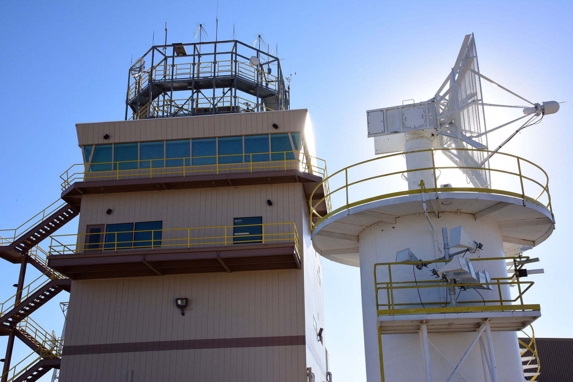
I uploaded a photo of one of the tower that is in front of the TTR control point. This is specific to the Sandia portion of the base. (If you trawl the site, very little of it is related to the USAF portion.) The upload meta data of the photo is Oct 24, 2017. The image date is 2/12/2014. Not so new, but new on the website.
On the control point building, the roof has the usual discones and probably monopoles for aircraft. The tower in the right of the image has some small microwave horn antennas mounted just below the big dish. If you look at the orientation of the horns, they appear to be perpendicular to each other, but pointed as pairs in the same direction. This is probably for isolation between horns. Generally this is referred to as cross polarization.
cross polarization
Not the best explanation at that link, but the idea is for each location, you use different polarizations for each antenna in an attempt to reduce cross talk between the antennas. This aids in full duplex comminications.
Now the two horn antennas pointing tower the left appear to point at Cedar Peak (37.706474° -116.334910°) The 4 antennas points towards the right point to an area off the range. Now that is somewhat interesting. My guess is the Warm Springs DOE sight (38.192098° -116.418306°), but I never saw a similar set over there.
Warm Springs repeater site
edit on 7-11-2017 by gariac because: (no reason given)
a reply to: mysterioustranger
The deal is a commercial entity can contract with the TTR. That is why they document their capabilities.
You are only viewing the Sandia portion of the base. The photos are only of Sandia complex and USAF tests Sandia has performed.
I suspect the USAF would like nothing better than to kick Sandia off the TTR. Nellis can't do anything secret. There are photographers outside the fence all the time. Creech is quite visible from 95. The TTR is remote enough that they hosted a UAV wing, publishing the existence of that wing, and no photo ever leaked.
originally posted by: gariac
a reply to: mysterioustranger
The deal is a commercial entity can contract with the TTR. That is why they document their capabilities.
You are only viewing the Sandia portion of the base. The photos are only of Sandia complex and USAF tests Sandia has performed.
I suspect the USAF would like nothing better than to kick Sandia off the TTR. Nellis can't do anything secret. There are photographers outside the fence all the time. Creech is quite visible from 95. The TTR is remote enough that they hosted a UAV wing, publishing the existence of that wing, and no photo ever leaked.
I compare it to the idiocy of something like the Illuminati running an "official" Illuminati website.. maintained by the real Illuminati.
Not logical, high unlikely, and improbable... People will believe anything...
All is questionable when the sources, info, and sites are.
a reply to: mysterioustranger
You do realize that is a subdomain of sandia.com Further, Sandia actually exists. It is currently run by Honeywell. Sandia has actual physical locations. It is quite real.
But you can show us all how that website is fake. We awaits your detailed analysis. Be specific, providing claims that are verifiable.
a reply to: gariac
Just trolling around their website, looking in the Maps link.
I see the main entry point at TTR is referred to as "Point Able Main Gate"
ttr.sandia.gov...
As you probably know, there is a "Point Bravo" gate on the SE side of the NTTR, off Hwy 95. Have you seen any other references to other gates referred to as "Point xxxxx"?
edit on 9-11-2017 by FosterVS because: (no reason given)
a reply to: FosterVS
No. Just ABLE and BRAVO.
My recollection is the range started out as Army land. I pulled a number of old maps off the University of Nevada archive. They may be on my website, but not in any intelligent organization. (TBD)
The present day Tonopah civilian airport was the old Army airport. That old hangar which I think you have a YouTube of was the Army Airforce hangar. You know about the bunkers by the race track and the rifle range across route 6. I guess the DoD was generous in giving up land in those days.
The old USGS topo maps show the town of Indian Springs as being on a military reservation.
A history of the range would be an interesting project, but it wouldn't have much of a spook appeal. What we need is some fool to get arrested and have his/her punishment be to write the history. That history of Rachel website was Glenn Campbell's public service related to some front gate incident. Glen locked a car door or something like that. It is in the Desert Rat newsletters.
www.rachel-nevada.com...
And a video, includes some detail about the actual facilities itself.
Any ideas which F-16 that is at 2:52? What aircraft is that at 6:34?
Seems to be a strange angle of a B-2 dropping a B61-12. The bomb spins up after it is ejected from the aircraft.
Any ideas which F-16 that is at 2:52? What aircraft is that at 6:34?
Seems to be a strange angle of a B-2 dropping a B61-12. The bomb spins up after it is ejected from the aircraft.
edit on 16/11/17 by C0bzz because: (no reason given)
originally posted by: C0bzz
And a video, includes some detail about the actual facilities itself.
Any ideas which F-16 that is at 2:52? What aircraft is that at 6:34?
Seems to be a strange angle of a B-2 dropping a B61-12. The bomb spins up after it is ejected from the aircraft.
Those bomb tests all have associated still photographs. Dig though B61-12 tests posted on ATS or search the interwebs.
Most of detail in those videos can be seen in stills on the official TTR website. The neutron detector looks different. Not that I ever figured out why they have them.
The video insisted on spelling out TSPI, but Googling TSPI will get you more hits.
new topics
-
Sleep paralysis and the implantation of some weird Matrix-esque demon creature...
The Gray Area: 33 minutes ago -
Say his name
US Political Madness: 1 hours ago -
There is no such thing as moonlight.
Space Exploration: 2 hours ago -
Breaking: 5 probed after 18-year old girl dies as a result of having the COVID jab
Diseases and Pandemics: 3 hours ago -
Official denial
Diseases and Pandemics: 5 hours ago -
MEGA - Let's Make Europe Great Again
Other Current Events: 6 hours ago -
Hamas and Other Islamist Terrorist Groups Announce Support of US Campus Anti-Israel Protests
Education and Media: 6 hours ago -
Psychotronic Operation Rwanda Who Wants To Be A Refugee?
ATS Skunk Works: 7 hours ago
top topics
-
Breaking: 5 probed after 18-year old girl dies as a result of having the COVID jab
Diseases and Pandemics: 3 hours ago, 11 flags -
Psychotronic Operation Rwanda Who Wants To Be A Refugee?
ATS Skunk Works: 7 hours ago, 5 flags -
Hamas and Other Islamist Terrorist Groups Announce Support of US Campus Anti-Israel Protests
Education and Media: 6 hours ago, 5 flags -
Official denial
Diseases and Pandemics: 5 hours ago, 5 flags -
AI phrenology
Science & Technology: 14 hours ago, 4 flags -
MEGA - Let's Make Europe Great Again
Other Current Events: 6 hours ago, 3 flags -
There is no such thing as moonlight.
Space Exploration: 2 hours ago, 3 flags -
Say his name
US Political Madness: 1 hours ago, 3 flags -
Sleep paralysis and the implantation of some weird Matrix-esque demon creature...
The Gray Area: 33 minutes ago, 1 flags
active topics
-
There is no such thing as moonlight.
Space Exploration • 8 • : AlexandrosOMegas -
Say his name
US Political Madness • 5 • : DAVID64 -
MEGA - Let's Make Europe Great Again
Other Current Events • 26 • : stonerwilliam -
Sleep paralysis and the implantation of some weird Matrix-esque demon creature...
The Gray Area • 2 • : CarlLaFong -
Supreme Court Oral Arguments 4.25.2024 - Are PRESIDENTS IMMUNE From Later Being Prosecuted.
Above Politics • 124 • : Sookiechacha -
University of Texas Instantly Shuts Down Anti Israel Protests
Education and Media • 386 • : CriticalStinker -
The theory that COVID-19 originated in China takes a body blow.
Diseases and Pandemics • 55 • : burritocat -
Psychotronic Operation Rwanda Who Wants To Be A Refugee?
ATS Skunk Works • 8 • : pianopraze -
Breaking: 5 probed after 18-year old girl dies as a result of having the COVID jab
Diseases and Pandemics • 13 • : stonerwilliam -
Hamas and Other Islamist Terrorist Groups Announce Support of US Campus Anti-Israel Protests
Education and Media • 10 • : FlyersFan
4